
Single Publication
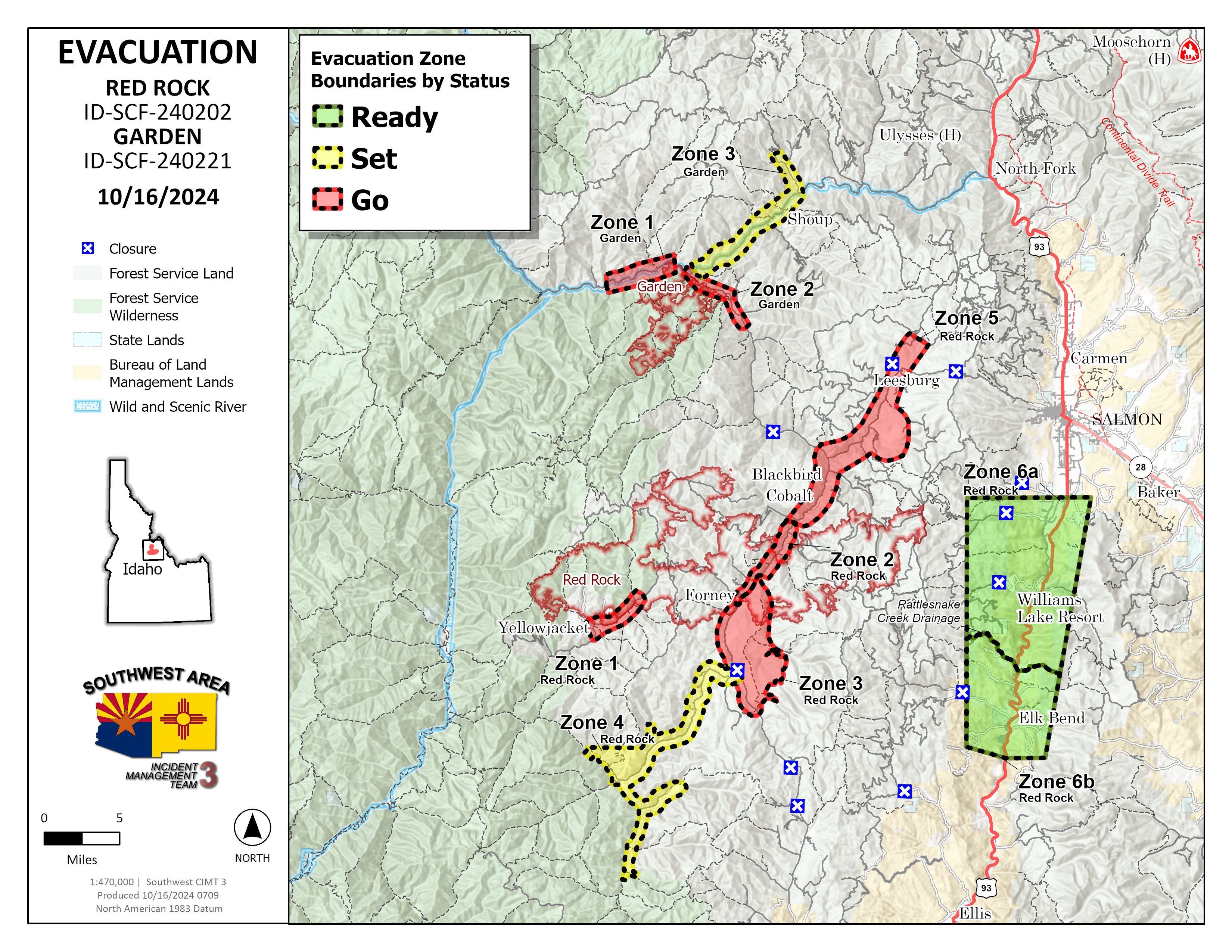
Garden and Red Rock Fires Update 10-16-2024
Publication Type: News - 10/16/2024 - 08:19
Cold front likely to bring precipitation tonight
Red Rock Fire
Operations: Yesterday crews checked for hotspots along the handline built off Blackbird Road (FR 115) around the mine. In and around Cobalt, crews built line around some more structures near the Panther Creek Road (FR 055). Uncrewed aircraft applied fire to the interior of the perimeter on the northeast side to remove fuels ahead of the cold front which could bring increased winds. Across the rest of the east and south sides of the fire, heavy equipment and crews strengthened containment lines and mopped up the fire’s edge. Mop up continued on the spot fire in Napias Creek where downed trees have made the task challenging, but there are no concerns for fire growth.
Today, much of the focus will be on the Williams Creek Summit, down the Ridge Road toward Lake Mountain and the dozer line construction off Moyer Peak. With the passage of the cold front, higher west winds will try to push the fire towards the east, making the Ridge Road preparation the focus. Elsewhere across the fire crews are backhauling unnecessary pumps, hose and supplies and preparing other equipment for below freezing temperatures. Firefighters continue to look for and extinguish any remaining heat.
Garden Fire
Operations: Crews continued to monitor, mop up and secure lines particularly in Panther Creek and the Salmon River corridor. There are no additional ignitions planned at this time. Today crews will continue to make sure fire doesn’t spot across the river or move towards the west.
Additional Information
Weather: A vigorous cold front is forecast to travel across the Pacific Northwest on Wednesday. Skies will become mostly cloudy, allowing temperatures to be 5-10 degrees cooler than yesterday with highs in the mid-50s to lower 60s. The relative humidity will be around 10-15 percent higher and around 50 to 35% in the afternoon. Southwest winds will increase during the day with gusts to 20-25 mph along the higher ridges. Rain is forecast to spread across north central Idaho and will develop over Lemhi County in the afternoon. Cold air behind the front will lower snow levels to near 6000 feet Wednesday night down to 5000 feet on Thursday.
Smoke: Information about protecting your health from wildfire smoke is available. A smoke outlook is also available.
Closures: Salmon‐Challis National Forest has implemented a reduced Red Rock and Garden Fires Closure, Order Number: 04‐13‐24‐026. Please refer to the link below to see further information regarding the closure reduction.
Safety: A Temporary Flight Restriction (TFR) is in place over the Red Rock and Garden fire areas, which includes uncrewed aircraft systems or drones. Reminder that if you fly we can’t, unauthorized drone flights pose serious risks to firefighter and public safety and the effectiveness of wildfire suppression operations.
Please stay out of the fire area. There is still active fire behavior in the fire area, including group torching and crown runs. There are multiple roads and bridges that have been destroyed or are impassable. Entry into evacuation zones that are in “Go” status is prohibited. The updated forest closure notice that encompasses both the Red Rock Fire and Garden Fire areas includes multiple road and area closures. Barricade closures will be posted at road intersections and forest boundaries.
Evacuations: For evacuation information in Lemhi County regarding both the Red Rock and Garden fires please go to: https://www.lemhicountyidaho.org/emergency-management-department.