U.S. flag

An official website of the United States government

Here's how you know

Single Incident Information

Zoom to your location
Reset map zoom and position

Could not determine your location.

Boundary Prescribed Fire

Share this incident

Unit Information

Florida 
Homestead, 
33034 
Florida 
Homestead, 
33034 

Incident Contacts

Erika Hoopes
Email: erika_hoopes@nps.gov
Hours: Monday - Friday, 9 am - 5 pm

Highlighted Activity

FOR IMMEDIATE RELEASEJanuary 17, 2025 Contacts:Public Information Officer Erika_hoopes@nps.govBig Cypress National Preserve Fire Duty Officer 561-923-5228Everglades National Park Fire Duty Officer 305-242-7850 South Florida interagency prescribed fire project extends… Read more
Publication Type: News -
OCHOPEE, FL – Big Cypress National Preserve has issued a temporary trail closure to promote visitor safety during prescribed fire activity beginning Monday, February 10, 2025. Closure includes all areas and trails within the treatment perimeter, as well as potential periodic closures along Loop Rd.  During the closure, all recreational use including off-road vehicles, airboats, hiking,… Read more
Publication Type: Closures -
Park managers at Everglades National Park and Big Cypress National Preserve have made a determination to postpone the Boundary Rx Burn Project at this time. We will re-announce when the project resumes.
Publication Type: Announcement -

Highlighted Media

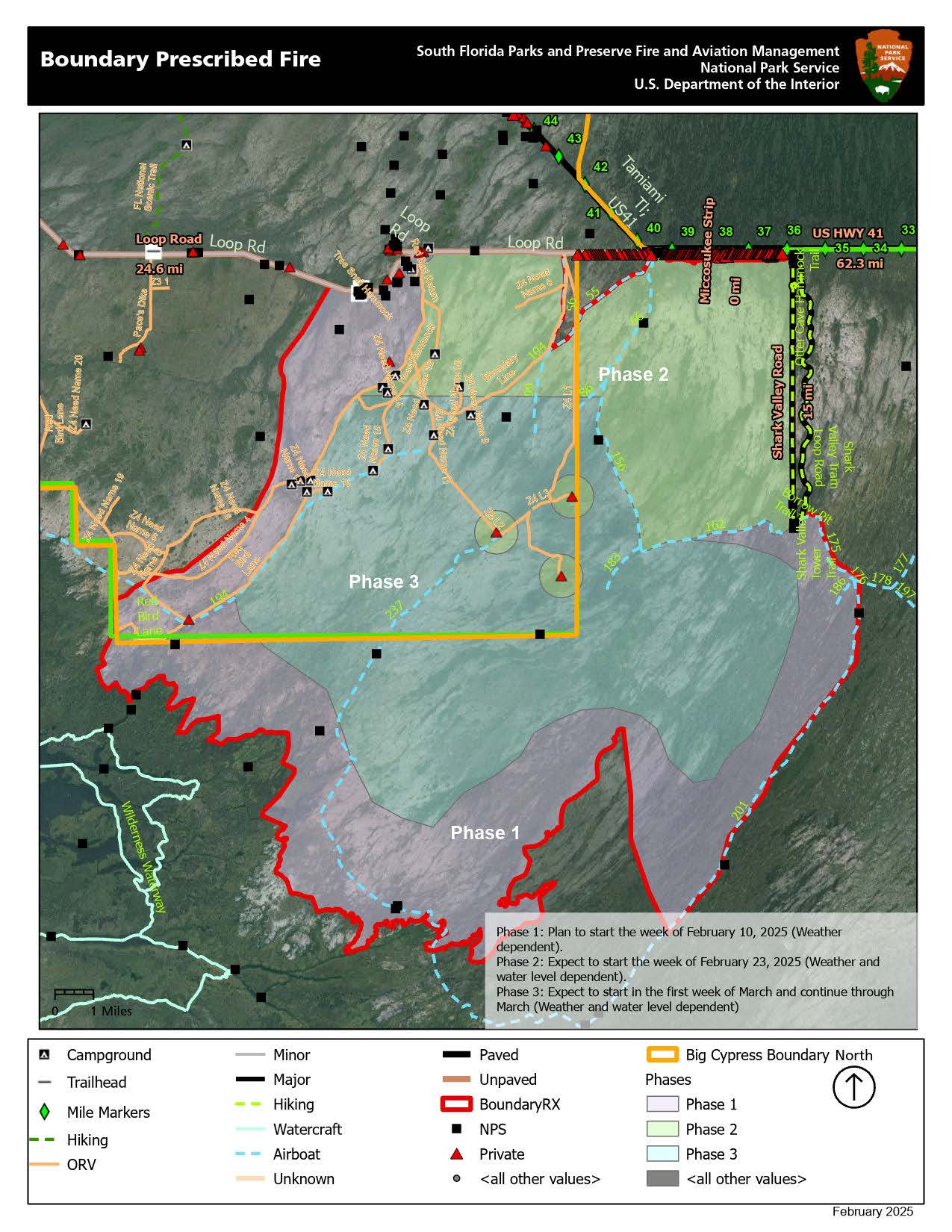
The National Park Service (NPS) in conjunction with the Miccosukee Tribe of Indians of Florida and the Bureau of Indian Affairs will be conducting a joint prescribed fire operation scheduled to begin in late January and continue through February. The 151,434-acre Boundary Prescribed Fire Project—located south of US Highway 41 between mile markers 36 and 44, including the Miccosukee Reserved Area—removes jurisdictional boundaries to complete prescribed burns with the assistance of federal, Tribal, state and local resources. The project aims to reduce hazardous fuel accumulations, create a critical fire break on the south side of the Miccosukee Reserved area to protect the Tribal Community from wildfire, enhance landscape resiliency, aid in ecosystem restoration, protect cultural values and improve firefighter and public safety. 

Basic Information
Current as of Tue, 02/11/2025 - 13:53
Incident Type Prescribed Fire
Coordinates 25 ° 45' 26'' Latitude
-80° 49'
21
'' Longitude