
Highlighted Media
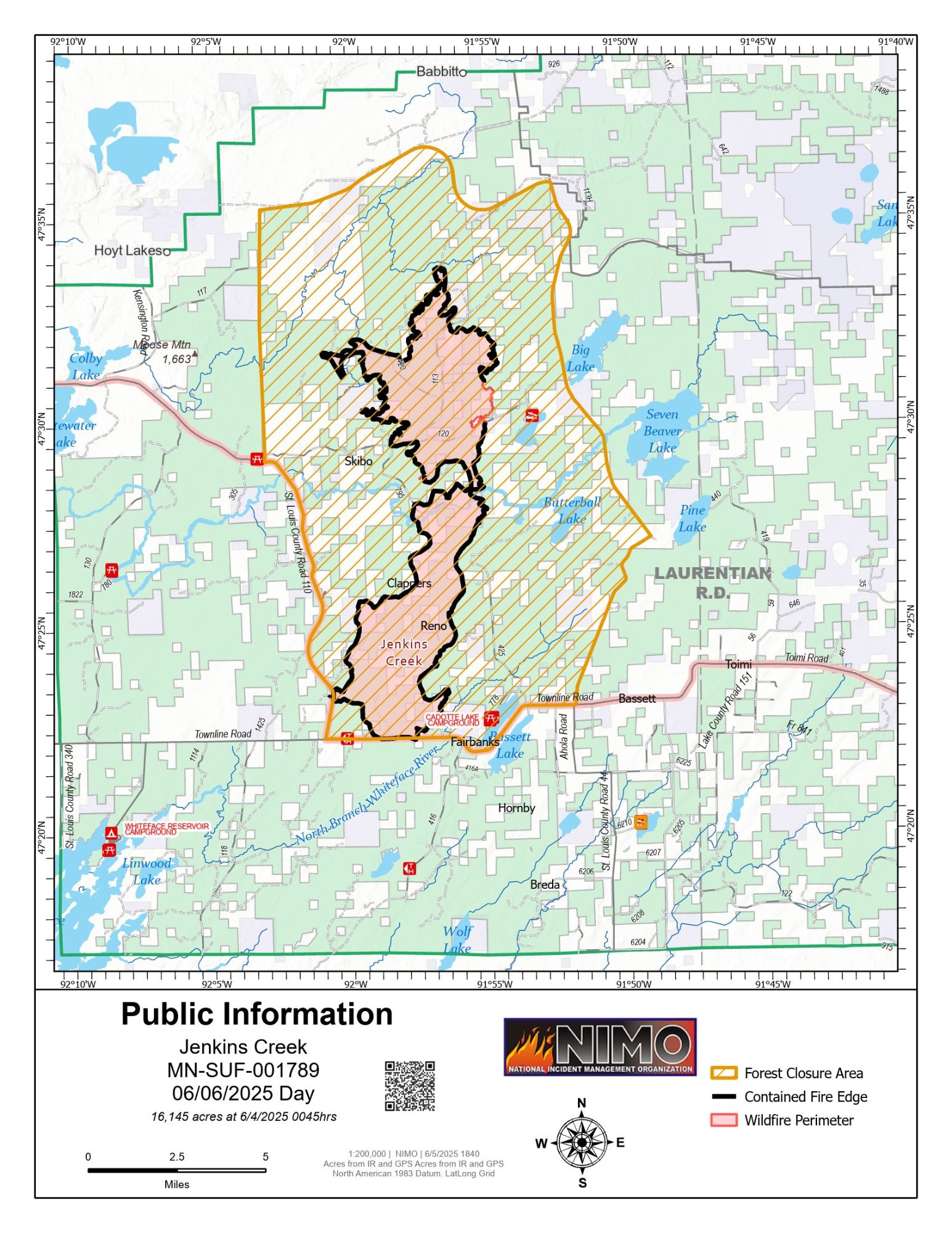
Jenkins Creek Fire Public Information Fire showing the fire at 16,145 acres and 94% contained
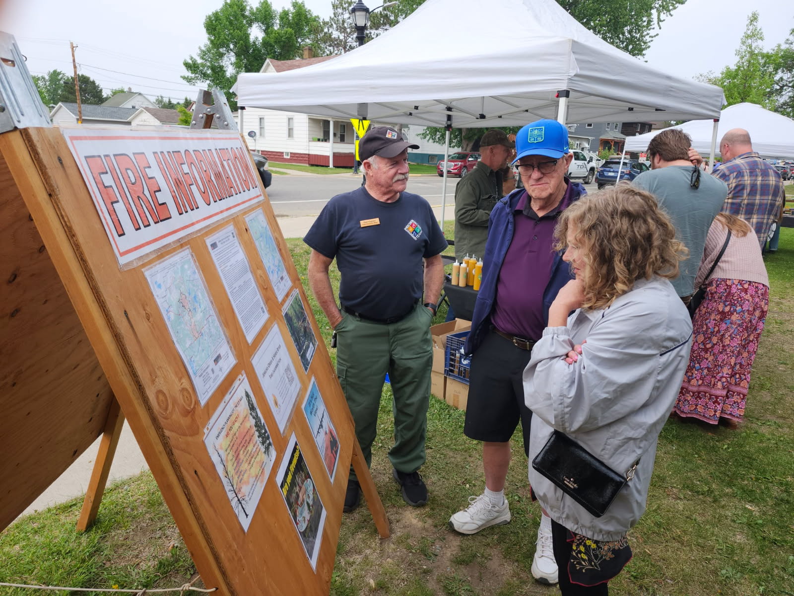
Information Officer Neal Kephart provides fire information for the Jenkins Creek and Horse River Fires at the Ely, Minnesota Farmer's Market.
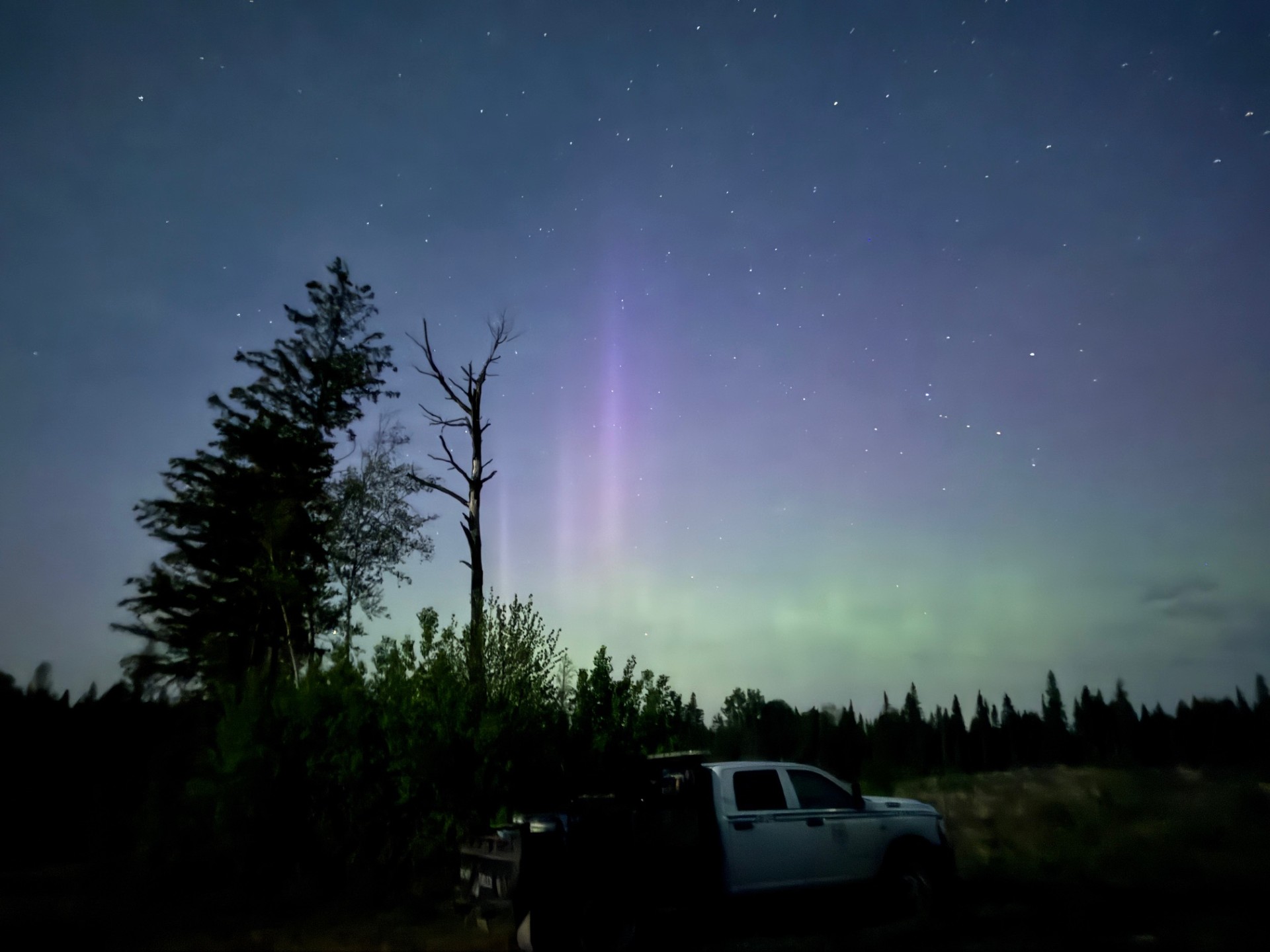
Photo depicts the northern lights over the Jenkins Creek Fire. Photo captured by the Unmanned Aerial System (UAS/drone) crew while surveying the area of the fire for heat signatures at night.
The Jenkins Creek Fire ignited on Monday, May 12, 2025, around 11:00 a.m. It was detected east of County Road 110 and north of County Road 16 near Jenkins Creek, approximately 15 miles southeast of Hoyt Lakes, Minnesota. The fire rapidly expanded due to hot temperatures, low relative humidity, and strong south winds, burning through mixed boreal forest and grassy ground cover, including areas heavily infested by spruce budworm, which contributed to the fire's intensity.
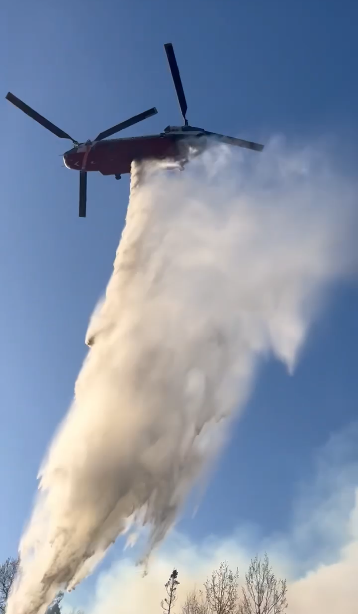
A National Incident Management Organization (NIMO) team took control of the fire on May 28, 2025 from the Eastern Area Complex Incident Management Team who took command of the fire on May 14. In addition to firefighting handcrews, resources deployed included multiple engines, bulldozers, tracked vehicles, and aerial support. Firefighters are focusing on full suppression tactics, structure protection, and establishing containment lines.
The fire initially exhibited extreme behavior, including crown fires and rapid spread through dense forested areas. The presence of dead and dying trees, particularly those affected by spruce budworm infestations, provided ample fuel for the fire's growth. After a couple days, the spread slowed as crews responded, winds subsided, and moisture moved into the area. Firefighters were able to take advantage of that opportunity and built line that held through another wind event a couple days later. Since then, containment has continued to be effectively established.
Evacuations have now been lifted. Some recreation site and road closures on Superior National Forest remain in effect.
Local communities and organizations, like the Red Cross and United Way, are supporting firefighting efforts and assisting displaced residents.
The Jenkins Creek Fire ignited on Monday, May 12, 2025, around 11:00 a.m. It was detected east of County Road 110 and north of County Road 16 near Jenkins Creek, approximately 15 miles southeast of Hoyt Lakes, Minnesota. The fire rapidly expanded due to hot temperatures, low relative humidity, and strong south winds, burning through mixed boreal forest and grassy ground cover, including areas heavily infested by spruce budworm, which contributed to the fire's intensity.
A National Incident Management Organization (NIMO) team took control of the fire on May 28, 2025 from the Eastern Area Complex Incident Management Team who took command of the fire on May 14. In addition to firefighting handcrews, resources deployed included multiple engines, bulldozers, tracked vehicles, and aerial support. Firefighters are focusing on full suppression tactics, structure protection, and establishing containment lines.
The fire initially exhibited extreme behavior, including crown fires and rapid spread through dense forested areas. The presence of dead and dying trees, particularly those affected by spruce budworm infestations, provided ample fuel for the fire's growth. After a couple days, the spread slowed as crews responded, winds subsided, and moisture moved into the area. Firefighters were able to take advantage of that opportunity and built line that held through another wind event a couple days later. Since then, containment has continued to be effectively established.
Evacuations have now been lifted. Some recreation site and road closures on Superior National Forest remain in effect.
Local communities and organizations, like the Red Cross and United Way, are supporting firefighting efforts and assisting displaced residents.
| Current as of | Fri, 06/06/2025 - 22:57 |
|---|---|
| Incident Time Zone | Central Standard Time |
| Incident Type | Wildfire |
| Cause | Undetermined |
| Date of Origin | |
| Incident Time Zone | Central Standard Time |
| Location | 15 miles SE of Hoyt Lakes, MN |
| Incident Commander | NIMO - National Incident Management Organization -NICKIE JOHNNY Incident Commander |
| Coordinates |
47° 22' 33'' Latitude
-91° 58' 64
'' Longitude
|
| Total Personnel: | 204 |
|---|---|
| Size | 16,145 Acres |
| Percent of Perimeter Contained | 94% |
| Estimated Containment Date | 06/15/2025 |
| Fuels Involved | Live fuel moisture in conifer trees remains low, meaning these trees are more susceptible to ignition and fire spread. While grasses are actively growing and hardwood trees have leafed out, which can slightly reduce fire behavior in some areas, heavy fuels—such as large downed logs and dead trees—remain dry and are capable of retaining heat for extended periods. Numerous areas of dead balsam fir from spruce budworm outbreak persist throughout the fire footprint. Several areas of interior green pockets of fuel still pose a risk of reburning. Additionally, firefighters have reported numerous falling snags (standing dead trees) throughout the incident area. These snags present significant safety hazards to personnel working on the fire and to anyone entering the area. Crews are working carefully to assess and manage these risks while continuing suppression efforts. |
| Significant Events | Cooler temperatures and weather this week will moderate fuel conditions. The Build-Up Index (BUI), an indicator of how dry forest fuels are, will stabilize for the week and fine fuels will be less available and largely extinguished. Suppression actions and naturally extinguished fuels have diminished fire behavior for a large portion of the fire area.
|
| Planned Actions |
Patrol, hold, and monitor remaining heat sources that threaten containment. Continued suppression repair in accordance to the incident resource advisors, to meet the approved Suppression Repair Plan. Allow BAER team members to provide initial assessments and severity impact. |
|---|---|
| Projected Incident Activity |
12 hours: Fire behavior should be subdued producing light minimal smoke. Remaining heat is primarily found n areas that have not been addressed challenging access and the presence of heavy snag components found mainly on the north end of the fire in Division JJ. |
| Weather Concerns | Observed: Light rain last night ended during the morning Friday with gradually clearing skies and light winds through the afternoon. Predicted: Increasing south winds expected on Saturday ahead of the next weather system. A few showers and thunderstorms are expected in the afternoon, before more numerous thunderstorms move through Saturday night. These storms may bring stronger winds during passage. Lighter showers are expected to continue during the say Sunday and again on Monday. |
|---|