
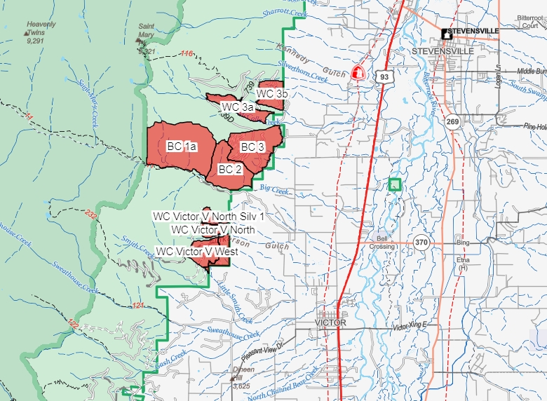
On the Stevensville Ranger District, the West Central 3b (WC 3b) may be treated between April 15 and 18 depending on weather conditions.
Access to the 739 Road (St. Mary’s) may be limited during ignition operations
The Bitterroot National Forest and partners are preparing to implement prescribed fire projects across the forest this Spring.
Prescribed fire is part of the Forest’s annual fire management program to reduce hazardous fuels, improve wildlife forage, and create conditions which minimize impacts from future wildfires around our communities.
Weather and conditions permitting, prescribed burns may occur starting in April and continue throughout the Spring.
| Current as of | Mon, 04/14/2025 - 17:21 |
|---|---|
| Incident Time Zone | America/Denver |
| Incident Type | Prescribed Fire |
| Location | West Central 3b Project Area, 4 miles southwest of Stevensville on the Stevensville Ranger District |
| Incident Commander | Stevensville Ranger District Bitterroot National Forest |
| Incident Description | Stevensville Ranger District plans to burn ~ 215 acres 4 miles southwest of Stevensville between McCalla Creek and Big Creek. Hand ignitions are planned. 25 firefighters, 2 engines and 1 water tender are assigned to the burn. To see locations visit https://usfs.maps.arcgis.com/apps/webappviewer/index.html?id=7b743b38029e4973b2e6523c976b097b |
| Coordinates |
46° 28' 26.3994'' Latitude
-114° 12' 25.1994
'' Longitude
|
| Total Personnel: | 40 and 3 engines |
|---|---|
| Size | 215 Acres |
| Fuels Involved | understory |
| Significant Events | Desired effects include fuels reduction to mitigate stand replacing fires along the Bitterroot Front and private property. |
| Remarks |
Watch for warning signs along roads near all prescribed fire areas before and during burns. Access to the 739 Road (St. Mary’s) may be limited during ignition operations |
|---|
| Weather Concerns | We will evaluate weather conditions in the hours before a burn begins. If conditions warrant, scheduled prescribed fire activities may be canceled. |
|---|