U.S. flag

An official website of the United States government

Here's how you know

Single Incident Information

Zoom to your location
Reset map zoom and position

Could not determine your location.

South Fork and Salt

Unit Information

New Mexico 
Mescalero, 
88340 
New Mexico 
Mescalero, 
88340 

Incident Contacts

Public Information Line
Email: 2024.southfork@firenet.gov
Phone: 575-323-8258 (public)/ 575-323-8378 (public) /575-323-8053 (media)
Hours: 8 AM - 8 PM

Highlighted Activity

Southwest AreaIncident Management TeamTEAM 5 – David Gesser – INCIDENT COMMANDER Severe flooding prompts evacuations, Crews to assist in flood mitigationDaily Update, Monday, July 1, 2024 Mescalero Apache Tribe Emergency Operations Center: 575-464-9214 (8am-6pm)Village of Ruidoso and Lincoln County Emergency Operations Center: 575-258-6900 (7am-10pm)Fire… Read more
Publication Type: News -

Highlighted Media

Originating on the Mescalero Apache Reservation, the South Fork and Salt fires started on Monday, June 17, 2024. The South Fork Fire was reported at 9:07 A.M. MDT and the Salt Fire was reported at 2:00 P.M. MDT. The South Fork Fire, threatening the community of Ruidoso, New Mexico, reached 15,000 acres within 24 hours and as of 3:00 P.M. on Tuesday, June 18, is under evacuation orders. Both fires are burning timber and mixed conifer threatening the community of Ruidoso, NM. The Bureau of Indian Affairs (BIA) Mescalero Agency responded immediately with local wildland firefighters from across multiple agencies and jurisdictions, exercising full suppression response.


Basic Information
Current as of Mon, 07/01/2024 - 09:56
Incident Time Zone America/Denver
Incident Type Wildfire
Cause Under investigation
Date of Origin
Location Ruidoso, NM area
Incident Commander Southwest Area Team 5, led by Incident Commander Dave Gesser, assumed command of the South Fork and Salt fires at 6:00AM, Wednesday, June 19, 2024.
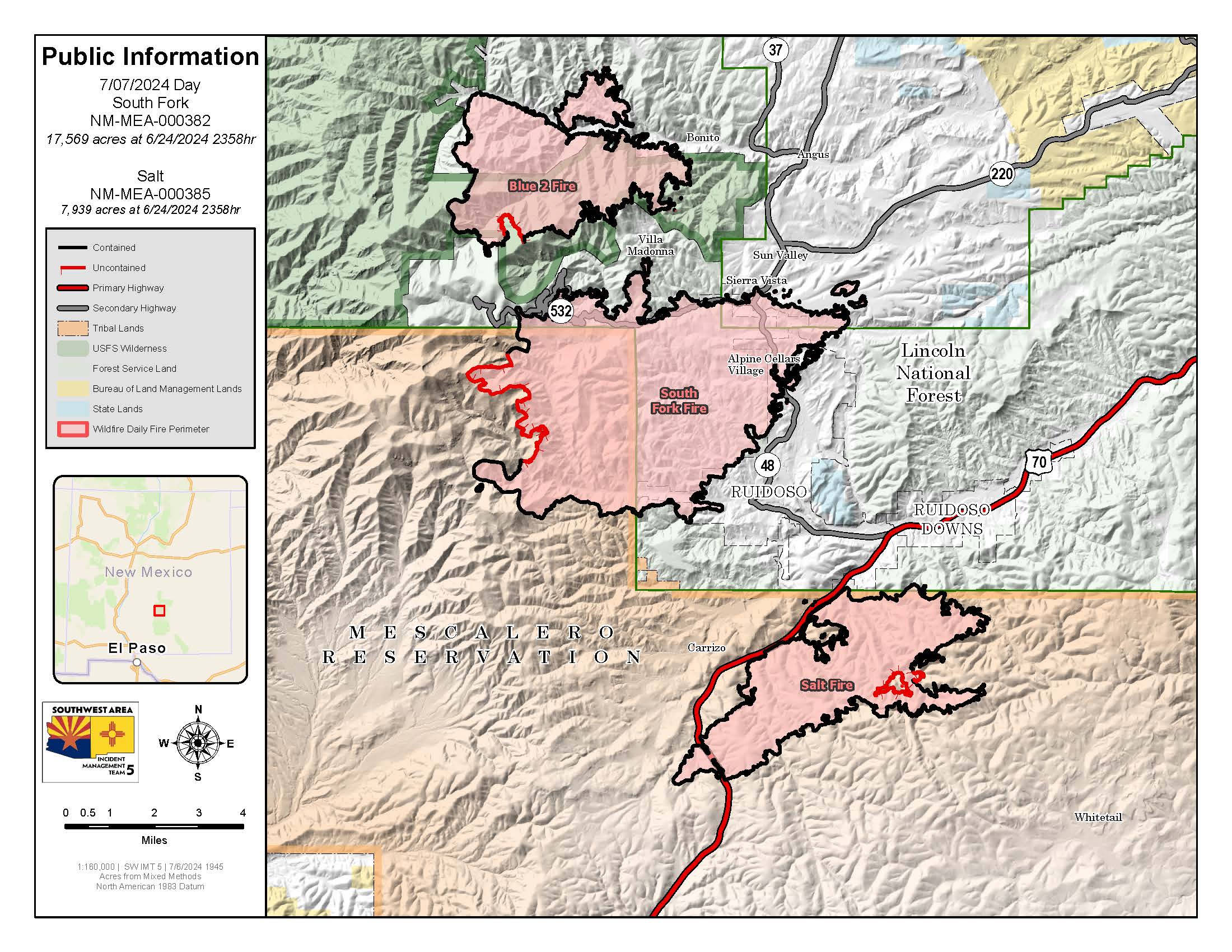
Incident Description The South Fork Fire is at 17,569 acres, 84% containment

The Salt Fire is at 7,939 acres, 84% containment

Both fires are located in the vicinity of: Ruidoso, NM

Resources: Crews, heavy equipment, engines, helicopters and air tankers.
Coordinates 33° 22' 16'' Latitude
-105° 45'
58
'' Longitude
Current Situation
Total Personnel: 690
Size 17,569 Acres
Percent of Perimeter Contained 84%
Estimated Containment Date 07/15/2024
Fuels Involved

Brush, Hardwood Litter and Timber.  

South Fork Fire: Fuels include short grass meadows, oak brush, pinyon-juniper, ponderosa pine, slash, and spruce/fir. Large diameter fuels are dry for the time of year due to the continuation of the long-term drought affecting the area. Where dead/down fuels exist beneath live canopies, the dead fuel acts as surrogate ladder fuels and a source of significant heat to ignite canopies and result in group torching and shortrange ember wash. 

Salt Fire: Large diameter fuels are dry for the time of year due to the continuation of the long-term drought affecting the area. Where dead/down fuels exist beneath live canopies, the dead fuel acts as surrogate ladder fuels and a source of significant heat to ignite canopies and result in group torching and shortrange ember wash. Typical fuels include short grass meadows, oak brush, pinyon-juniper, Ponderosa pine, slash, and spruce/fir.

Significant Events

South Fork Fire: The South Fork Fire received significant rain late in the previous burn period which further suppressed the remaining heat sources. The majority of remaining heat sources on the South Fork Fire are actively charring downed logs located interior of control lines.

Salt Fire: The "lower jaw" on the southern flank of Div. Tango on the Salt Fire is the only area with a significant density of adjacent hot spots relatively close to the existing fire perimeter. The hot spots in this location are in a "dirty burn" within a stand of very dense mixed conifer containing multiple snags and a juniper understory. These hot spots within this area continue to smolder and produce small amounts of localized smoke which does not impact nearby roadways and the heat sources themselves are unlikely to grow or threaten lines.

Outlook
Planned Actions

South Fork Fire: Crews will emphasize constructing direct control lines on the west side of the incident to protect values at risk and increase containment. Mop up along established control lines is underway and will continue for the foreseeable future. Suppression repair work on constructed containment lines will begin where appropriate and where access is possible. Structure assessments will continue. Assigned personnel will provide initial attack response to any new starts within the TFR. Crews are also assisting utility cooperators in gaining access to damaged areas.

Salt Fire: Mop up operations, and suppression repair activities are underway and will continue for the foreseeable future.
Assigned personnel will provide initial attack response to any new starts within the TFR.

Projected Incident Activity

South Fork Fire

12 hours: The few remaining consistent heat sources are isolated charred downed logs slowly smoldering more than 100 yards from control lines. These logs pose little to no threat to control lines.

24 hours:  Continued smoldering of individual isolated charred logs. Less cloud cover will allow more direct sunlight to affect the burned area allowing for a slight increase in smoldering and consumption of residual heat sources.

Salt Fire

12 hours:  The area known colloquially as the "Lower Jaw" contains the majority of the detected heat sources. These heat sources are primarily individual pockets of smoldering duff within a mixed conifer stand and were the result of numerous spot fires during the active growth phase of the Salt Fire over a week ago. The resultant "dirty burn" will continue to smolder and may even begin to creep at a glacial rate, but unless an extended pronounced hot, dry, and windy weather phase establishes over the area, fire behavior more aggressive than smoldering and slow creeping is unlikely.

24 hours:  The numerous smoldering patches in the "Lower Jaw" on the southern perimeter are expected to continue smoldering and very limited creeping. The area is heavily shaded by closed canopy mixed conifer which also effectively blocks wind. The increased direct sunlight due to lack of cloud cover is offset by the closed canopy which will likely result in no increase or decrease of fire activity. Continued smoldering of deep duff and isolated logs in the "lower jaw".

Remarks

South Fork Fire: The fire area received significant rainfall yesterday, which caused high flows and flooding within the fire
perimeter and the Village of Ruidoso. Another flood event occurred today in Ruidoso and the surrounding area. 

A Temporary Flight Restriction (TFR) is in place over the fire area. Drone flights are also prohibited within this area. Visit
https://www.tfr.faa.gov for more information. 

A South Fork Fire Emergency Closure Order is in place for national forest lands within the Smokey Bear Ranger District. The identified areas, and roads and trails therein, are closed to public access to provide enhanced safety of firefighting personnel and the public. The Lincoln National Forest has also implemented forest-wide Stage II fire restrictions. For more information, visit https://www.fs.usda.gov/lincoln. 

SWA Team 5 is also managing the Salt Fire.

Salt Fire:  The Temporary Flight Restriction (TFR) remains in effect but has been reduced. Visit https://www.tfr.faa.gov for more information. Drone flights are also prohibited within this area. 

A South Fork Fire Emergency Closure Order was issued on 6/20/2024 for national forest lands within the Smokey Bear Ranger District. The identified areas, and roads and trails therein, are closed to public access to provide enhanced safety of firefighting personnel and the public. The Lincoln National Forest has also implemented forest-wide Stage II fire restrictions. For more information, visit https://www.fs.usda.gov/lincoln. 

SWA Team 5 is managing the Salt Fire.

Current Weather
Weather Concerns

South Fork Fire: Yesterday there were only a few storms over the Sacramento mountains, but they all converged and stalled over the South Fork Fire. The fire got 1-2" of rain that caused flooding out of all the main arteries and minor drainages of the Rio Ruidoso, Cedar Creek, and Eagle Creek drainages, with major impacts to Ruidoso and surrounding communities. 

Today, the fire got a second consecutive day of direct hits with multiple showers and thunderstorms forming over or tracking across the burn scar. Most of the fire got measurable rain, with multiple gauges recording 0.5"
to 1.50". 

On Monday and Tuesday, a disturbance will slowly track east, to our north, across the Central Rockies. This passing feature will slightly weaken the ridge aloft and allow for some minor gains in instability. With moisture remaining in place, increasing chances and wider coverage of showers and thunderstorms will be possible in the vicinity of, and possibly over, the fires.

Salt Fire: Sunday, high pressure aloft nosed back over the fire from the east and shoved some of the deeper moisture well to our west; but more than adequate moisture remained over the fire producing 2-4" of rain and catastrophic flooding. Temperatures were seasonally warm, but cooler and closer to normal, in the 75°-85° range. Afternoon minimum relative humidity stayed elevated and above 40 percent. 

On Monday and Tuesday, we see a disturbance slowly track east, to our north, across the Central Rockies. With moisture remaining in place over the fire, we should see increasing chances, and wider coverage of showers and thunderstorms in the vicinity of, and possibly over, the fire. 

Through the week ahead, high pressure will keep temperatures warm, with daily highs near or above normal. Monsoonal moisture will rise and fall, but never leave the Sacramento mountains, with dewpoints mostly in the 50s, and relative humidity generally above 30 percent. That means each day will have varying chances for showers and storms near or over the fires.