Highlighted Activity
Highlighted Media

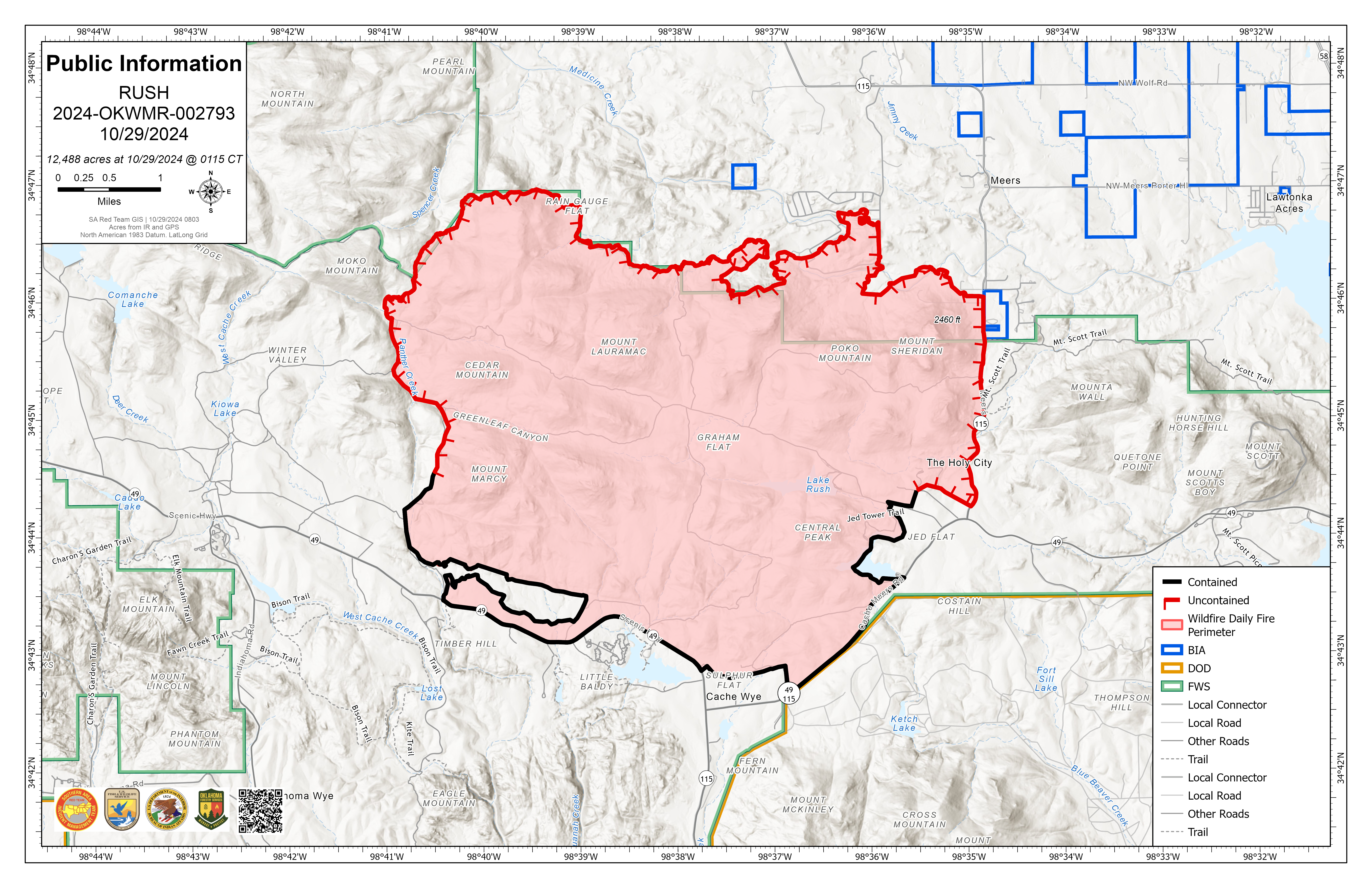
Rush Fire Public Information Map for 10-29-2024
Attention: At 11:00am on November 2, 2024, there was a Transfer of Command from. SA Red Team back to the home unit - Wichita Mountains Wildlife Refuge.
This page will not be updated moving forward.
Fior information on the Rush Fire, contact: email wmr_visitorservices@fws.gov or call 580-215-1858.
The Rush Fire was first reported on private land in Comanche County on October 24, 2024. It is currently burning primarily on Wichita Mountains National Wildlife Refuge, with only approximately 400 acres off refuge.
Beginning October 28, the Southern Area Red Complex Incident Command Team assumed command of the fire with a delegation to coordinate firefighters and community partners to protect life and property and manage suppression efforts.
| Current as of | Sat, 11/02/2024 - 10:57 |
|---|---|
| Incident Time Zone | America/Chicago |
| Incident Type | Wildfire |
| Cause | undetermined |
| Date of Origin | |
| Location | Lawton, OK |
| Incident Commander | Pat Pearson, Incident Commander, Southern Area Red CIMT Wichita Mountains National Wildlife Refuge DOI-USFWS |
| Coordinates |
34° 44' 33'' Latitude
-98° 36' 20
'' Longitude
|
| Total Personnel: | 200 |
|---|---|
| Size | 12,488 Acres |
| Percent of Perimeter Contained | 87% |
| Estimated Containment Date | 11/08/2024 |
| Fuels Involved | Timber (Grass and Understory) Tall Grass (2.5 feet) Brush (2 feet) Tall grass prairie and post oak savannah mixed with junipers. Extended period of drought with NFRDS values near record indices. |
| Significant Events | Minimal Backing Creeping Smoldering Heavy fuels and unburned riparian areas continue to burn but are well interior. The majority of fire behavior was limited to creeping and smoldering. |
| Planned Actions |
Due to anticipated weather conditions tomorrow, limited work will be accomplished. Divisions will continue with suppression repair along the east side of the fire in coordination with the lead READ and land owners. |
|---|---|
| Projected Incident Activity |
12 hours: Limited potential for fire spread. Some short-range spotting is possible but unlikely, surface spread is unlikely. 24 hours: Limited potential for fire spread. 48 hours: Limited potential for fire spread. 72 hours: Limited potential for fire spread. Anticipated after 72 hours: Limited potential for fire spread. |
| Remarks |
Blocks 31/32: Block32 incorrectly indicates that 125 responders were evacuated. This should have been in Block 31 to indicate that 125 members of the public were evacuated. 1098 ACRES on Oklahoma Division of Forestry (OK-OKS) 11390 ACRES on Wichita Mountains National Wildlife Refuge (OK-WMR) |
| Weather Concerns | Clouds were on the increase Friday as the next major storm system approaches the region. High Temperatures were in the 70s with generally light winds out of the southeast. Showers and storms will arrive during the day Saturday with periods of heavy rainfall leading to flash flooding. This is especially a concern on and around the burn scar where the soil cannot easily absorb water. By Monday morning, the area could see a total of 3-6 inches of rain. Severe weather is also possible with each round of storms. Drier conditions are expected to return early next week. |
|---|

 InciWeb