
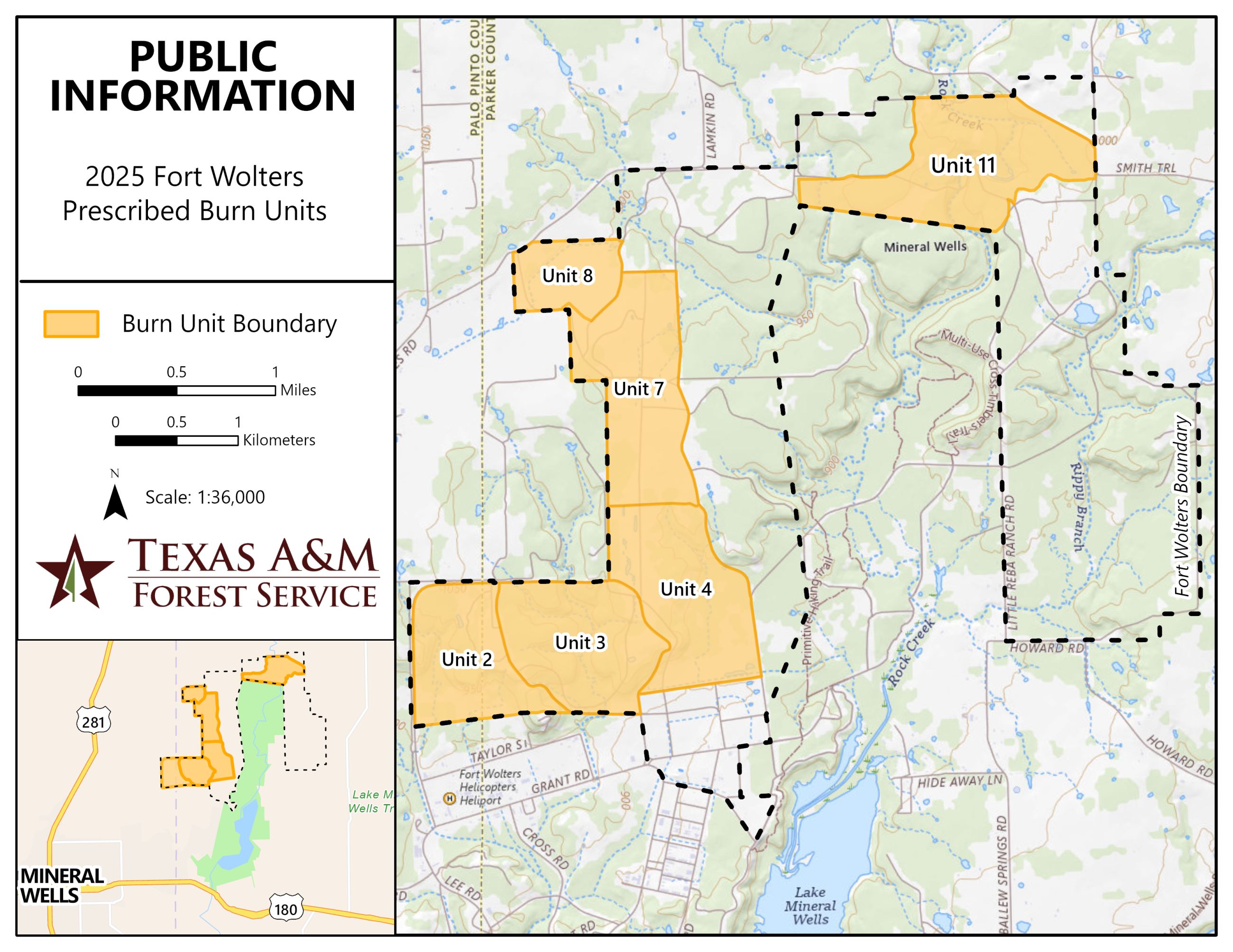
Texas A&M Forest Service is planning for prescribed burns to take place at Fort Wolters during 2025. Six burn units identified as units 2, 3, 4, 7, 8, and 11 will be burned for a total of 1,678 acres.
These burns are designed to meet multiple land management objectives including reducing the accumulation of hazardous fuels, improve forest health, improve access and visibility for forest management activities and improve wildfire habitat.
Each prescribed burn unit has defined weather parameters and firing patterns to ensure the objectives for each unit have a high potential for success. Texas A&M Forest Service personnel will monitor all prescribed burns to evaluate achievement of goals and help guide future prescriptions.
Unit 3 – 286 acres
Burning Date: 4/14/2025
Crews will be conducting a burn on Fort Wolters Army National Guard today and will be in the area. Smoke will be visible from the area and can be expected.
Unit 2 – 228 acres
Proposed burning dates: 11/2024 – 5/2025
Unit 4 – 316 acres
Proposed burning dates: 11/2024 – 5/2025
Unit 7 – 328 acres
Proposed burning dates: 11/2024 – 5/2025
Unit 8 – 119 acres
Proposed burning dates: 11/2024 – 5/2025
Unit 11 – 400 acres
Proposed burning dates: 11/2024 – 5/2025
Nearby residents can expect some lingering smoke effects overnight after the burns and may see some moderate to heavy smoke impacts for short periods during ignition operations. These effects will be mitigated by burning on days with good ventilation so that smoke will be dispersed away from communities.
More information will be published as weather conditions allow for safe burning operations.
| Current as of | Mon, 04/14/2025 - 11:03 |
|---|---|
| Incident Time Zone | America/Chicago |
| Incident Type | Prescribed Fire |
| Date of Origin | |
| Location | Northeast of Mineral Wells, Texas |
| Incident Commander | Texas A&M Forest Service |
| Coordinates |
32° 50' 22'' Latitude
-98° 2' 25
'' Longitude
|