


Afton,Wyo., April11 th, 2025— The Bridger-Teton National Forest is planning prescribed fire operations this month and into April. We estimate this work to continue through the spring as weather conditions allow. We use prescribed fires to help reduce overgrown vegetation to help protect local communities, infrastructure and natural resources from wildfires.
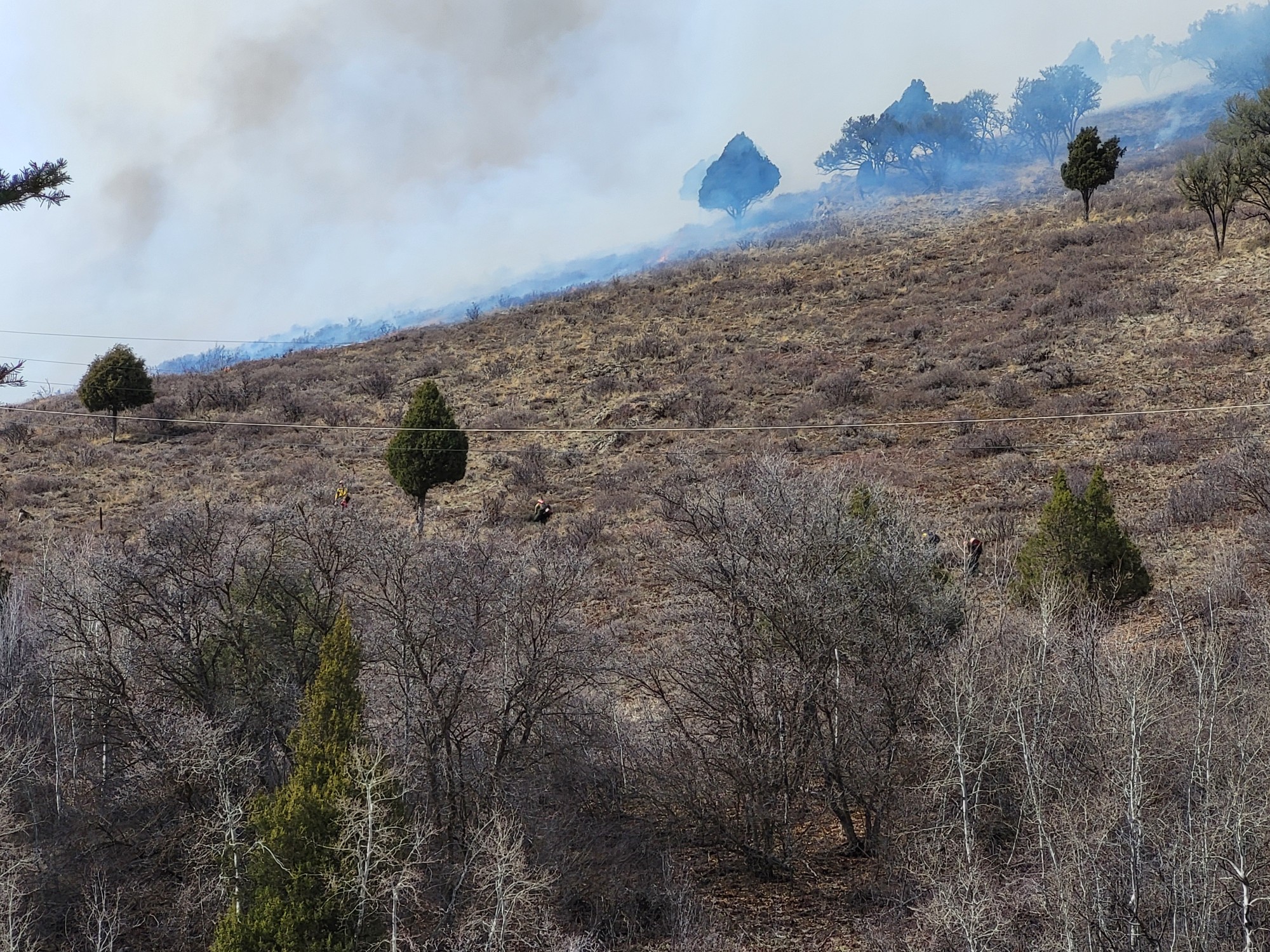
The Greys River Ranger District of the Bridger-Teton National Forest plans to implement up to 2,500 acres Prescribed Burn in Unit 2. Unit 2 is within the Star Valley Front Vegetation Restoration Project. Star Valley Front, Unit 2 is comprised of the southwest facing slopes visible from Afton and Grover. Unit 2 also includes south facing slopes in the Swift Creek Drainage which is an important watershed for the community of Afton. Reducing fuel loading on the landscape can decrease the extent and severity of future wildfire. This provides for both Firefighter safety and for resource protection.
Another important purpose is to improve the vigor of vegetation on mule deer and elk winter and transition range, which is particularly relevant given the great interest in deer and elk populations in the Star Valley area.
There may be temporary trail and road closures periodically during the day as equipment and firefighters are working in the area. Watch for warning signs along roads near all prescribed fire areas before and during burns.
Residents can expect smokey conditions the day of the burn and into the overnight hours. Some smoke may exist the following day but should dissipate considerably thereafter. Go to https://fire.airnow.gov/ to find more detailed information about air quality.
We will evaluate weather conditions in the hours before a burn begins. If conditions warrant, scheduled prescribed fire activities may be canceled. Firefighters will use the snow as a hold feature to prevent fire spread outside the unit.
Afton,Wyo., April11 th, 2025— The Bridger-Teton National Forest is planning prescribed fire operations this month and into April. We estimate this work to continue through the spring as weather conditions allow. We use prescribed fires to help reduce overgrown vegetation to help protect local communities, infrastructure and natural resources from wildfires.
The Greys River Ranger District of the Bridger-Teton National Forest plans to implement up to 2,500 acres Prescribed Burn in Unit 2. Unit 2 is within the Star Valley Front Vegetation Restoration Project. Star Valley Front, Unit 2 is comprised of the southwest facing slopes visible from Afton and Grover. Unit 2 also includes south facing slopes in the Swift Creek Drainage which is an important watershed for the community of Afton. Reducing fuel loading on the landscape can decrease the extent and severity of future wildfire. This provides for both Firefighter safety and for resource protection.
Another important purpose is to improve the vigor of vegetation on mule deer and elk winter and transition range, which is particularly relevant given the great interest in deer and elk populations in the Star Valley area.
There may be temporary trail and road closures periodically during the day as equipment and firefighters are working in the area. Watch for warning signs along roads near all prescribed fire areas before and during burns.
Residents can expect smokey conditions the day of the burn and into the overnight hours. Some smoke may exist the following day but should dissipate considerably thereafter. Go to https://fire.airnow.gov/ to find more detailed information about air quality.
We will evaluate weather conditions in the hours before a burn begins. If conditions warrant, scheduled prescribed fire activities may be canceled. Firefighters will use the snow as a hold feature to prevent fire spread outside the unit.
| Current as of | Mon, 04/14/2025 - 11:22 |
|---|---|
| Incident Time Zone | America/Denver |
| Incident Type | Prescribed Fire |
| Date of Origin | |
| Location | Afton Wyoming |
| Incident Commander | Burn Boss: Will Hall Agency: United States Forest Service |
| Incident Description | This area is comprised of the southwest facing slopes visible from Afton and Grover and consists of timber, grass, and mountain brush |
| Coordinates |
42° 44' 612'' Latitude
-110° 55' 57.18
'' Longitude
|
| Size | 455 Acres |
|---|---|
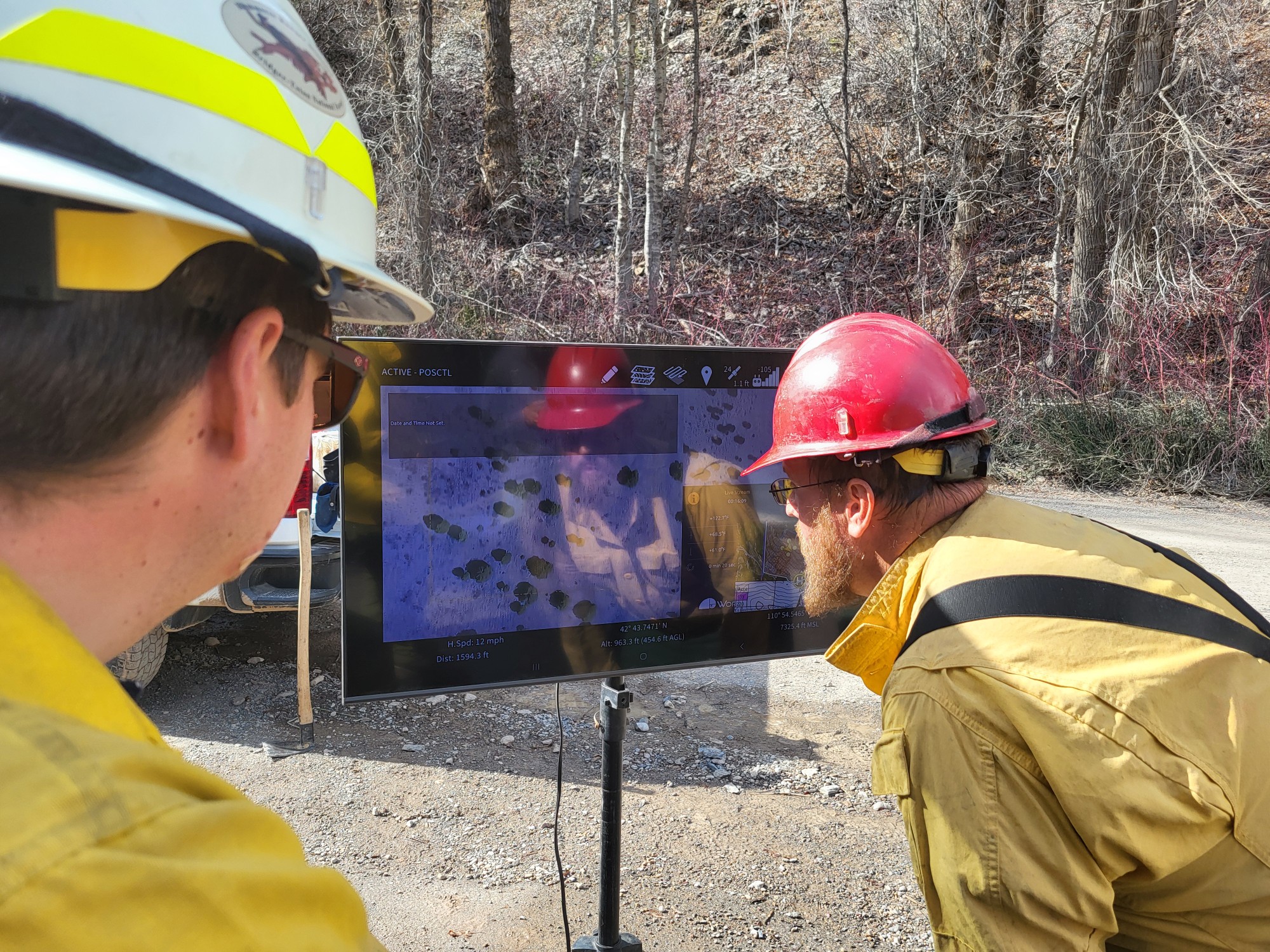
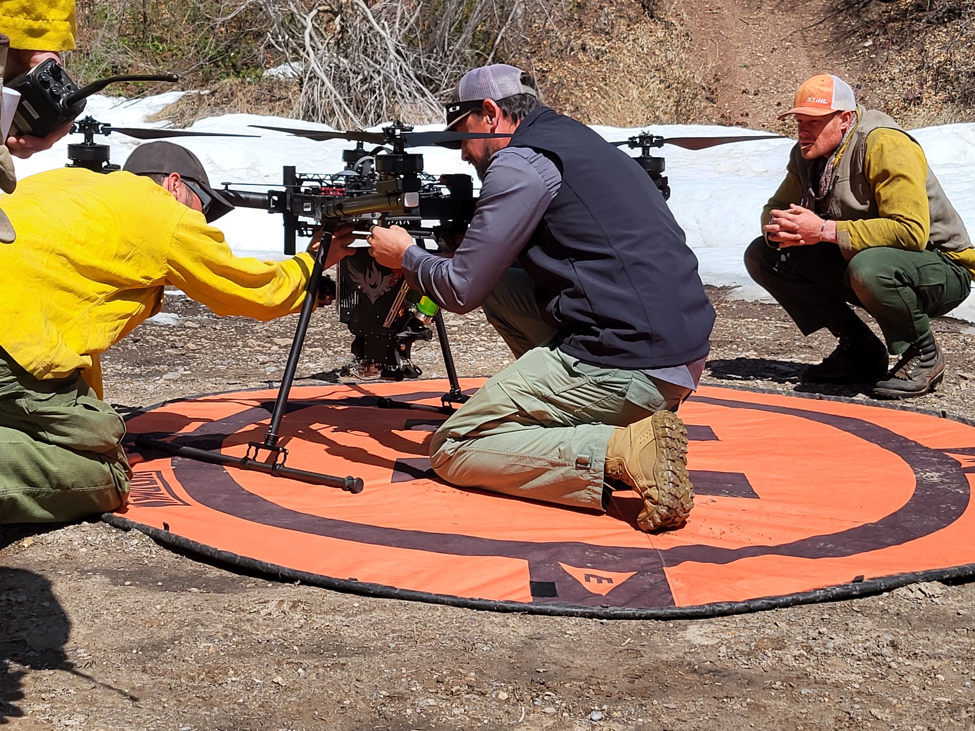
| Significant Events | These ignitions will be assisted by the use of a UAS delivery system, commonly known as a "drone". 250 acres were treated on Thursday April 10, 2025. As of Friday April 11, 2025, 455 acres were treated.
|
| Projected Incident Activity |
Smoke may be visible and persist throughout the day. Ignitions take place on Thursday April 10, 2025 between 11:00am and 3:00pm. The Alta X type 3 drone or Unmanned Aerial System (UAS) can carry 450 "ping pong balls" at one time. Some UAS are compatible with aerial ignition devices called plastic sphere dispenser capabilities. These dispensers are capable of dropping incendiary objects from the aircraft, a function previously restricted to helicopters. Ping-pong balls, or “dragon eggs,” are filled with a chemical powder form of potassium permanganate and then injected with glycol upon release, causing a chemical reaction that ignites the ping-pongs. They are loaded into a hopper attached to larger drones and dropped. Using these in prescribed fire activities help forest managers achieve a mosaic burn, which replicates natural fires. |
|---|---|
| Remarks |
40 acres were blacklined on Wednesday, March 26, 2025 to prep for future spring prescribed burning if weather and conditions allow. A "blackline" refers to a firebreak created by burning a strip of fuel adjacent to a control line or natural barrier, ensuring a clean boundary to prevent the fire from spreading beyond the intended area. There was light smoke during ignitions and smoke is expected to continue. April 10th, there were 10 acres of completed black line. |