
Incident Publication
HAOE LEAD Fire Daily Update Wednesday April 23 2025 04 23 2025
Related Incident: HAOE LEAD
Publication Type: News
Size: 3,103 acres Location: 7 miles west of Robbinsville, NC. County: Graham
Start Date: April 12, 2025 Cause: Lightning Containment: 29% Total Personnel: 124
ROBBINSVILLE, N.C., April 23, 2025 - The Haoe Lead Fire is burning within and adjacent to the Joyce Kilmer-Slickrock Wilderness on the Cheoah Ranger District of the Nantahala National Forest, approximately 7 miles west of Robbinsville, North Carolina, and 2 miles west of Lake Santeetlah. The fire is entirely on National Forest System lands, and no private lands or structures are threatened. No evacuations in effect or anticipated. The Southern Area Gray Team is managing this fire under a full suppression strategy using existing barriers and a combination of direct and indirect tactics. The fire is burning hardwood leaf litter and shrubs in steep and rugged terrain, and much is within the fire scar of the 2016 Maple Springs Fire.
Yesterday’s Activities – Significant precipitation fell across the fire area beginning Monday evening and continued throughout the day Tuesday, with rain gauges on the fire recording amounts of 0.75 inches to more than an inch. The fire did not grow in size on Tuesday. Fire activity was minimal throughout the day, with only scattered heavy fuels and stumps smoking. Fire crews patrolled roads and fire lines along and near the fire perimeter.
Today’s Activities – Damp and rainy conditions will continue today and will keep fire activity minimal. Significant additional rainfall is expected. Firefighters will continue to patrol and monitor the fire lines and fire perimeter for any smoldering or smoking heavy fuels, logs and stumps. Crews will remove hoselays and other water handling equipment from the area near the Joyce Kilmer Memorial Loop Trail (TR 43) and begin suppression repair work to naturalize handlines and dozer lines on the east and south portions of the fire. Some resources are being reassigned to other wildfires.
Weather and Smoke – Cloudy and rainy weather will continue today, with scattered thunderstorms possible. Additional rainfall accumulations of more than an inch are possible. Smoke from the fire will be minimal today. Air quality information can be found at https://fire.airnow.gov/.
Closures - The USDA Forest Service closure order for the area around the Haoe Lead Fire remains in effect for the safety of both the public and fire personnel. The closed area includes the North Carolina portion of the Joyce Kilmer-Slickrock Wilderness and non-Wilderness lands in the Santeetlah Road area.
Most trails in the Joyce Kilmer-Slickrock Wilderness remain closed, including Joyce Kilmer Memorial Loop. Several of these closed trails are sections of the Benton MacKaye Trail. In addition, Santeetlah Road and the Big Santeetlah Creek area are closed to all public use.
Aircraft and Drone Restrictions – The Temporary Flight Restriction (TFR) for the area around the fire has been lifted. Firefighting aircraft are still active on the Haoe Lead Fire. Public drone (UAS) use near the fire remains prohibited due to the risk of interference with aviation assets. If you fly, we can’t.
Bee Rock Creek Fire 42325 04 23 2025
Related Incident: 2025 Bee Rock Creek Fire - NCNCF
Publication Type: News
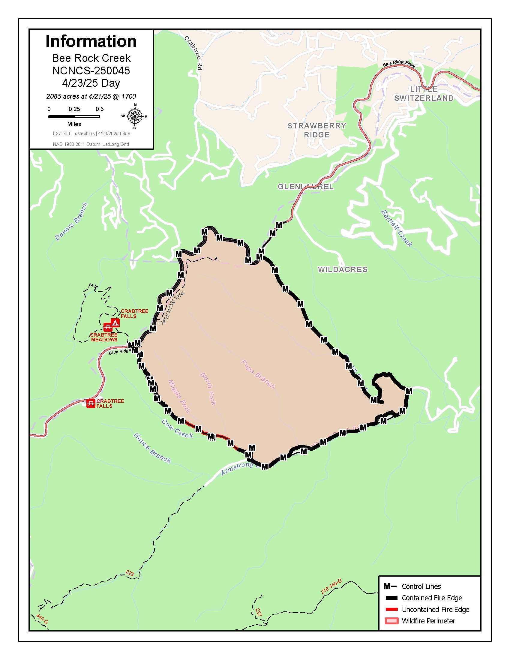
Bee Rock Creek Fire Update for 4/23/25 – Grandfather Ranger District – McDowell County
The Bee Rock Creek Fire area in McDowell County received about a quarter inch of rain in the last 48 hours and more rain is expected through Thursday. The 2,085-acre fire is now 94% contained.
This is the final daily update. Follow the National Forests in North Carolina on Facebook at www.facebook.com/nfsnc for additional information.
The National Forests in North Carolina closed the area of the Bee Rock Creek Fire between Armstrong Creek Road and the Blue Ridge Parkway for public safety.
Some sections of the Blue Ridge Parkway are also closed. Check the National Park Service website for details before visiting.
Camp Underburn Update 04 22 2025
Related Incident: Camp Underburn
Publication Type: Announcement
Fire and fuels personnel successfully completed 73 acres on the Tahoe National Forest Camp Underburn today. Resources will remain on scene through the night to monitor. Ignitions are planned to begin again tomorrow, April 23.
Low intensity fire now can help reduce the risk of high intensity fire later.
HAOE LEAD Fire Daily Update Tuesday April 22 2025 04 22 2025
Related Incident: HAOE LEAD
Publication Type: News
Size: 3,103 acres Location: 7 miles west of Robbinsville, NC. County: Graham
Start Date: April 12, 2025 Cause: Lightning Containment: 29% Total Personnel: 179
ROBBINSVILLE, N.C., April 22, 2025 - The Haoe Lead Fire is burning within and adjacent to the Joyce Kilmer-Slickrock Wilderness on the Cheoah Ranger District of the Nantahala National Forest, approximately 7 miles west of Robbinsville, North Carolina, and 2 miles west of Lake Santeetlah. The fire is entirely on National Forest System lands, and no private lands or structures are threatened. No evacuations in effect or anticipated. The Southern Area Gray Team is managing this fire under a full suppression strategy using existing barriers and a combination of direct and indirect tactics. The fire is burning hardwood leaf litter and shrubs in steep and rugged terrain, and much is within the fire scar of the 2016 Maple Springs Fire.
Yesterday’s Activities – The burnout operation on the south side of the fire between Little Santeetlah Creek and Santeetlah Road (FSR 81) on Monday was successful in consuming the burnable vegetation near the established firelines in this area and securing this portion of the fire. Crews on the ground were supported by two heavy helicopters throughout the day. Precipitation began falling on the fire area late on Monday and continued throughout the night.
Today’s Activities – Precipitation is expected to continue across the fire area today, greatly reducing fire activity. Fire crews will patrol roads along and near the fire perimeter throughout the day, mopping up any smoke or heat they encounter. Hoselays near the Memorial Loop remain in place. The public should use caution on all area roads and avoid travel near the fire.
Weather and Smoke – Today will be mostly cloudy with rain and rain showers throughout the day with a chance of thunderstorms. Rain amounts of up to 0.75 inches are likely with rain continuing tonight and tomorrow. Although reduced, smoke may be visible from area roads and communities. Air quality information can be found at https://fire.airnow.gov/.
Closures - The USDA Forest Service closure order for the area around the Haoe Lead Fire remains in effect for the safety of both the public and fire personnel. The closed area includes the North Carolina portion of the Joyce Kilmer-Slickrock Wilderness and non-Wilderness lands in the Santeetlah Road area.
Most trails in the Joyce Kilmer-Slickrock Wilderness remain closed, including Joyce Kilmer Memorial Loop (TR 43). Several of these closed trails are sections of the Benton MacKaye Trail. In addition, Santeetlah Road, and the Big Santeetlah Creek area are closed to all public use.
Aircraft and Drone Restrictions - A Temporary Flight Restriction (TFR) continues in effect for the area around the fire. No public aircraft of any type, including drones (UAS), are allowed within the TFR area. Unauthorized drone use near a fire poses serious risks to firefighters and forces suspension of aerial firefighting operations. If you fly, we can’t.
Bee Rock Creek Fire Update 04 22 2025
Related Incident: 2025 Bee Rock Creek Fire - NCNCF
Publication Type: News
Firefighters increased containment to 50% on the 2,085-acre Bee Rock Creek Fire in McDowell County yesterday. Most of the added containment is next to the Blue Ridge Parkway. Although the east and west sides of the fire are uncontained, firefighters used drones with infrared cameras and found little to no heat near firelines. Crews also repaired areas disturbed by suppression activities.
The fire area is predicted to receive about 1/3 inch of rain today.
Nearly all of the personnel assigned to the fire will demobilize to return home or to other incidents.
The National Forests in North Carolina closed the area of the Bee Rock Creek Fire between Armstrong Creek Road and the Blue Ridge Parkway for public and firefighter safety.
Some sections of the Blue Ridge Parkway are also closed. Check the National Park Service website for details before visiting.
Prescribed Burns Planned for the Pagosa Ranger District 04 21 2025
Related Incident: 2025 San Juan National Forest Prescribed Fire Program
Publication Type: News
PAGOSA SPRINGS, Colo., April 21, 2025— The San Juan National Forest’s Pagosa Ranger District is planning to conduct a prescribed burn in the Turkey Springs area starting as early as April 30th. The 885-acre Brockover-Devil Prescribed Fire project is located 8 miles northwest of Pagosa Springs.
Project area specifics:
- Location: Turkey Springs area, approximately ½ mile from the Hatcher Subdivision, immediately adjacent to NFSR roads 629 (Lower Turkey Springs) and 923 (Newt Jack Road).
- Smoke Impacts: During operations smoke may be visible from Pagosa Springs, PLPOA, County Rd 600 between Highway 160 and Piedra River Trailhead, and Highway 160 between Timberline Ridge and downtown Pagosa Springs. Smoke monitoring will be conducted, and ignitions will be scheduled to minimize smoke impacts to communities. Prescribed fire smoke may affect your health. More information can be found online: https://www.colorado.gov/pacific/cdphe/wood-smoke-and-health.
- Why: The Pagosa Ranger District has implemented multiple vegetation treatments in the Brockover and Turkey Springs areas. This work reduces hazardous fuels, such as pine litter, dried needle cast and brush. Prescribed fire can reduce the risk of wildfire impacting communities and infrastructure under less favorable conditions. In addition, reducing surface fuels promotes new grass and forb growth, providing forage for many wildlife species.
- Closures: No official closures are in place but there will be traffic control on NFSR 629 and 923 during operations. Forest users should avoid National Forest System Trails 305, 313, 316 and portions of 301, 302 and 323 during burn operations.
Burning operations may take place over multiple days, but are always dependent upon multiple conditions, including personnel availability, fuel conditions, weather and approval from the Colorado Department of Public Health and Environment. Prescribed burns may be changed or canceled last-minute if burn conditions do not meet criteria outlined in advance.
Maps of the prescribed burn units and additional San Juan National Forest prescribed fire program news can be found on InciWeb. For more information, please contact Brian Austin, Pagosa Ranger District Fuels Specialist at brian.austin@usda.gov. or by phone at (970) 264-2268.
For information about the San Juan National Forest, call (970) 247-4874, visit the forest website, or follow us on social media (Twitter and Facebook).
-USDA-
USDA is an equal opportunity provider, employer, and lender.
HAOE LEAD Fire Daily Update Monday April 21 2025 04 21 2025
Related Incident: HAOE LEAD
Publication Type: News
Size: 2,436 acres Location: 7 miles west of Robbinsville, NC. County: Graham
Start Date: April 12, 2025 Cause: Lightning Containment: 12% Total Personnel: 158
ROBBINSVILLE, N.C., April 21, 2025 - The Haoe Lead Fire is burning within the Joyce Kilmer-Slickrock Wilderness on the Cheoah Ranger District of the Nantahala National Forest, approximately 7 miles west of Robbinsville, North Carolina, and 2 miles west of Lake Santeetlah. The Southern Area Gray Team is managing this fire under a full suppression strategy using existing barriers and a combination of direct and indirect tactics. The fire is burning predominantly in hardwood leaf litter in steep and rugged terrain. Much of this fire is burning in the fire scar of the 2016 Maple Springs Fire.
Yesterday’s Activities – The Haoe Lead Fire grew slightly to the southwest yesterday to near the Wilderness boundary on Horse Cove Ridge. Heavy helicopters dropped water on active portions of the fire throughout the day. On the east side of the fire near Maple Springs Overlook Road (SR 1127), firefighters patrolled and mopped up remaining heavy fuels near the firelines. On the south side of the fire, firefighters completed and improved handline from west of the Joyce Kilmer Memorial Forest over Horse Cove Ridge south to Santeetlah Road (FSR 81). They completed and tested portable pumps and hoselays near the Memorial Loop Trail. On the southwest side of the fire, firefighters constructed both handline and dozerline in the Wolf Laurel Branch and Stratton Bald areas. On the northwest side of the fire, personnel scouted future fireline locations.
Today’s Activities – Firefighters will conduct a burnout operation on the southeast side of the fire from Little Santeetlah Creek southward towards Santeetlah Road (FSR 81). The public can expect to see increased smoke from this planned operation throughout the day. This burnout will consume the burnable vegetation near the established firelines to secure this area against any future fire spread. Aviation assets will support this operation as necessary. On the southwest side of the fire, crews will continue to construct and improve firelines in the Stratton Bald area. Firefighters will continue to scout and assess potential future fireline locations on the west and northwest portions of the fire in the Wilderness. On the east side, engine crews will continue to patrol and mop up along Maple Springs Overlook Road (SR 1127).
Weather and Smoke - Today will be partly sunny with a high temperature of 79 degrees, minimum humidity of 42 percent, and southwest winds of 7-9 mph with gusts to 28 mph. Light rain may begin in the late afternoon and continue overnight. Planned burnout operations will result in increased smoke visible throughout the day. Smoke may be visible from area roads and communities. Air quality information can be found at https://fire.airnow.gov/.
Closures - The Haoe Lead Fire is burning entirely on National Forest System lands. There are no evacuations in effect at this time. The public should use caution on all area roads. The USDA Forest Service closure order for the area around the Haoe Lead Fire remains in effect for the safety of both the public and fire personnel. The closed area includes the North Carolina portion of the Joyce Kilmer-Slickrock Wilderness including the Joyce Kilmer Memorial Forest, and non-Wilderness lands in the Santeetlah Road (Forest Service Road 81) area.
The following trails remain closed: Slickrock Creek (TR 42), Joyce Kilmer Memorial Loop (TR 43), Haoe Lead (TR 53), Jenkins Meadow (TR 53A), Stratton Bald (TR 54), Naked Ground (TR 55), Hangover Lead (TR 56), Wolf Laurel (TR 57) and Strawberry Knob (TR 217-H). Several of these local trails are also sections of the Benton MacKaye Trail. In addition, Santeetlah Road (FSR 81), Wolf Laurel Road (FSR 81F) and the Big Santeetlah Creek area are closed.
Aircraft and Drone Restrictions - A Temporary Flight Restriction (TFR) is in effect for the fire area. No public aircraft of any type, including drones, are allowed within the TFR area. Unauthorized drone (UAS) flights pose serious risks to wildfire suppression operations. Aerial firefighting is suspended when unauthorized UAS are in the area, allowing wildfires to grow larger. If you fly, we can’t.
Bee Rock Creek Fire Update for 42125 Grandfather Ranger District McDowell County 04 21 2025
Related Incident: 2025 Bee Rock Creek Fire - NCNCF
Publication Type: News
Firefighters successfully completed strategic firing operations to reduce unburned fuels on the Bee Rock Creek Fire in McDowell County near the Armstrong State Fish Hatchery. Today firefighters will continue mopping up hotspots, securing containment lines and patrolling the fire’s edge. They are also repairing areas disturbed by suppression activities. This includes installing water bars on dozer lines to reduce erosion.
After careful coordination and evaluation of current fire behavior and containment progress, McDowell County Emergency Management lifted the evacuation order for residences on Wild Acres Road and Wild Acres Retreat. Officials urge residents to remain cautious and aware of any ongoing firefighting activity in the area.
The 1,397-acre fire is 27% contained with 159 personnel from the USDA Forest Service, North Carolina Forest Service, National Park Service, McDowell County and Woodlawn Fire Department.
The National Forests in North Carolina closed the area of the Bee Rock Creek Fire between Armstrong Creek Road and the Blue Ridge Parkway for public and firefighter safety.
Some sections of the Blue Ridge Parkway are also closed. Check the National Park Service website for details before visiting.
A Temporary Flight Restriction is in place over the fire area each day from 10 a.m. to midnight. See the map at https://tfr.faa.gov/tfr3/?page=detail_5_7644. Aircraft, including drones, are prohibited from flying to provide a safe environment for firefighting. If you fly, we can’t. If a drone is spotted near the fire, all aircraft are grounded until the drone is clear of the area.
Please be aware of smoke and crews in the area. Drive slowly and use caution on roads where smoke may be settling. Check air quality at https://airquality.climate.ncsu.edu/ or https://fire.airnow.gov.
HAOE LEAD Fire Daily Update Sunday April 20 2025 04 20 2025
Related Incident: HAOE LEAD
Publication Type: News
Size: 2,043 acres Location: 7 miles west of Robbinsville, NC. County: Graham
Start Date: April 12, 2025 Cause: Lightning Containment: 0% Total Personnel: 94
ROBBINSVILLE, N.C., April 20, 2025 – The Haoe Lead Fire is burning within the Joyce Kilmer-Slickrock Wilderness on the Cheoah Ranger District of the Nantahala National Forest, approximately 7 miles west of Robbinsville, North Carolina, and 2 miles west of Lake Santeetlah. The Southern Area Gray Team is managing this fire under a full suppression strategy using existing barriers and a combination of direct and indirect tactics. The fire is burning predominantly in hardwood leaf litter in steep and rugged terrain. Much of this fire is burning in the fire scar of the 2016 Maple Springs Fire.
Yesterday’s Activities – Firefighters constructed handlines and began deploying hoselays and other protection measures in the Little Santeetlah Creek and Horse Cove Ridge areas to keep the fire away from the Joyce Kilmer Memorial Forest and Memorial Loop Trail. A heavy helicopter dropped water throughout the day on the most active portions of the fire. Personnel patrolled the eastern portion of the fire along and near Maple Springs Overlook Road (SR 1127) and strengthened containment features there. Fire managers scouted the western and southwestern sides of the fire for future containment line opportunities.
Today’s Activities – On the east side of the fire along and near Maple Springs Overlook Road (SR 1127), firefighters will patrol and mop up areas near the firelines, searching out any stumps or heavy fuels still burning after the strategic firing operations two days ago. On the south side of the fire, crews will continue to improve existing firelines and construct additional handlines to the west of the Joyce Kilmer Memorial Forest and southward to Santeetlah Road (FSR 81). Firefighters will install portable pumps and hoselays near the Memorial Loop Trail for additional protection in this area if needed. On the west side of the fire, firefighters will begin construction of both handline and dozer line in the Wolf Laurel Branch and Stratton Bald areas. Dozer work will only be done on land outside of the Joyce Kilmer-Slickrock Wilderness. Aviation assets are available and will be utilized as needed.
Weather and Smoke – Today will be partly sunny with a high temperature of 81 degrees, minimum humidity of 42 percent, and light winds from the south. Today’s higher humidity and lighter winds are expected to aid fire suppression efforts. Fire activity is expected to increase in the afternoon, particularly on south and west facing slopes. Smoke may be visible from area roads and communities. Air quality information can be found at https://fire.airnow.gov/.
Closures – The Haoe Lead Fire is burning entirely on National Forest System lands. There are no evacuations in effect at this time. However, the public is asked to use caution on all area roads.
The USDA Forest Service closure order for the area around the Haoe Lead Fire remains in effect for the safety of both the public and fire personnel. The closed area includes the North Carolina portion of the Joyce Kilmer-Slickrock Wilderness including the Joyce Kilmer Memorial Forest, and non-Wilderness lands in the Santeetlah Road (Forest Service Road 81) area.
The following trails remain closed: Slickrock Creek (TR 42), Joyce Kilmer Memorial Loop (TR 43), Haoe Lead (TR 53), Jenkins Meadow (TR 53A), Stratton Bald (TR 54), Naked Ground (TR 55), Hangover Lead (TR 56), Wolf Laurel (TR 57) and Strawberry Knob (TR 217-H). Several of these local trails are also sections of the Benton MacKaye Trail. In addition, Santeetlah Road (FSR 81), Wolf Laurel Road (FSR 81F) and the Big Santeetlah Creek area are closed.
Aircraft and Drone Restrictions – A Temporary Flight Restriction (TFR) is in effect for the fire area. No public aircraft of any type, including drones, are allowed within the TFR area. Unauthorized drone (UAS) flights pose serious risks to the effectiveness of wildfire suppression operations. Aerial firefighting is suspended when unauthorized UAS are in the area, allowing wildfires to grow larger. If you fly, we can’t.
Bee Rock Creek Fire Update for 42025 Grandfather Ranger District McDowell County 04 20 2025
Related Incident: 2025 Bee Rock Creek Fire - NCNCF
Publication Type: News
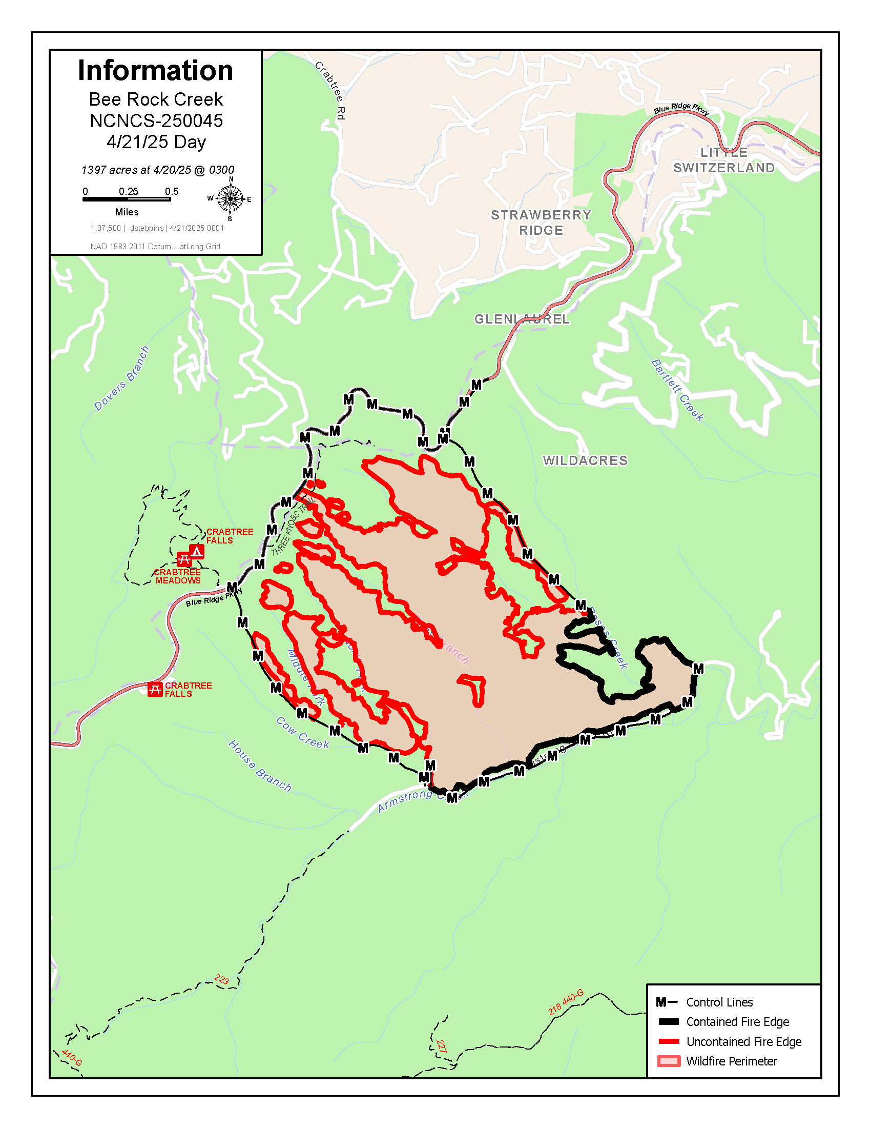
Firefighters continue suppression operations on the 1,314-acre Bee Rock Creek Fire burning in steep terrain and storm debris in McDowell County near the Armstrong State Fish Hatchery. The fire is 27% contained and has 195 personnel from the USDA Forest Service, North Carolina Forest Service, National Park Service, McDowell County and Woodlawn Fire Department.
Yesterday, firefighters began strategic firing operations to reduce unburned fuel between the fire’s north edge and the Blue Ridge Parkway and between dozer lines extending from the east and west sides of the fire up to the Parkway. Firefighters use carefully planned strategic firing operations while weather conditions will keep fire behavior low. This brings the fire to specific control features where there is the best chance of safely and successfully containing the fire. This work is expected to be completed today. Smoke from this planned event may affect McDowell, Mitchell and Yancey counties.
Firefighters will also be mopping up around the edges of the fire, using drones with infrared cameras to search for sources of heat and extinguishing them to secure containment.
The National Forests in North Carolina has closed the area of the Bee Rock Creek Fire between Armstrong Creek Road and the Blue Ridge Parkway for public and firefighter safety.
Some sections of the Blue Ridge Parkway are also closed. Check the National Park Service website for details before visiting.
McDowell County Emergency Management has issued an evacuation order for all residences on Wild Acres Road off of NC 226 A. Click to view McDowell County’s live evacuation map.
A Temporary Flight Restriction is in place over the fire area each day from 10 a.m. to midnight. See the map at https://tfr.faa.gov/tfr3/?page=detail_5_7644. Aircraft, including drones, are prohibited from flying to provide a safe environment for firefighting. If you fly, we can’t. If a drone is spotted near the fire, all aircraft are grounded until the drone is clear of the area.
Please be aware of smoke and crews in the area. Drive slowly and use caution on roads where smoke may be settling. Check air quality at https://airquality.climate.ncsu.edu/ or https://fire.airnow.gov.