
Incident Publication
Red Rock and Black Eagle Fire Daily Update 09 30 2024
Related Incident:
Publication Type: News
FIRE ACTIVITY:
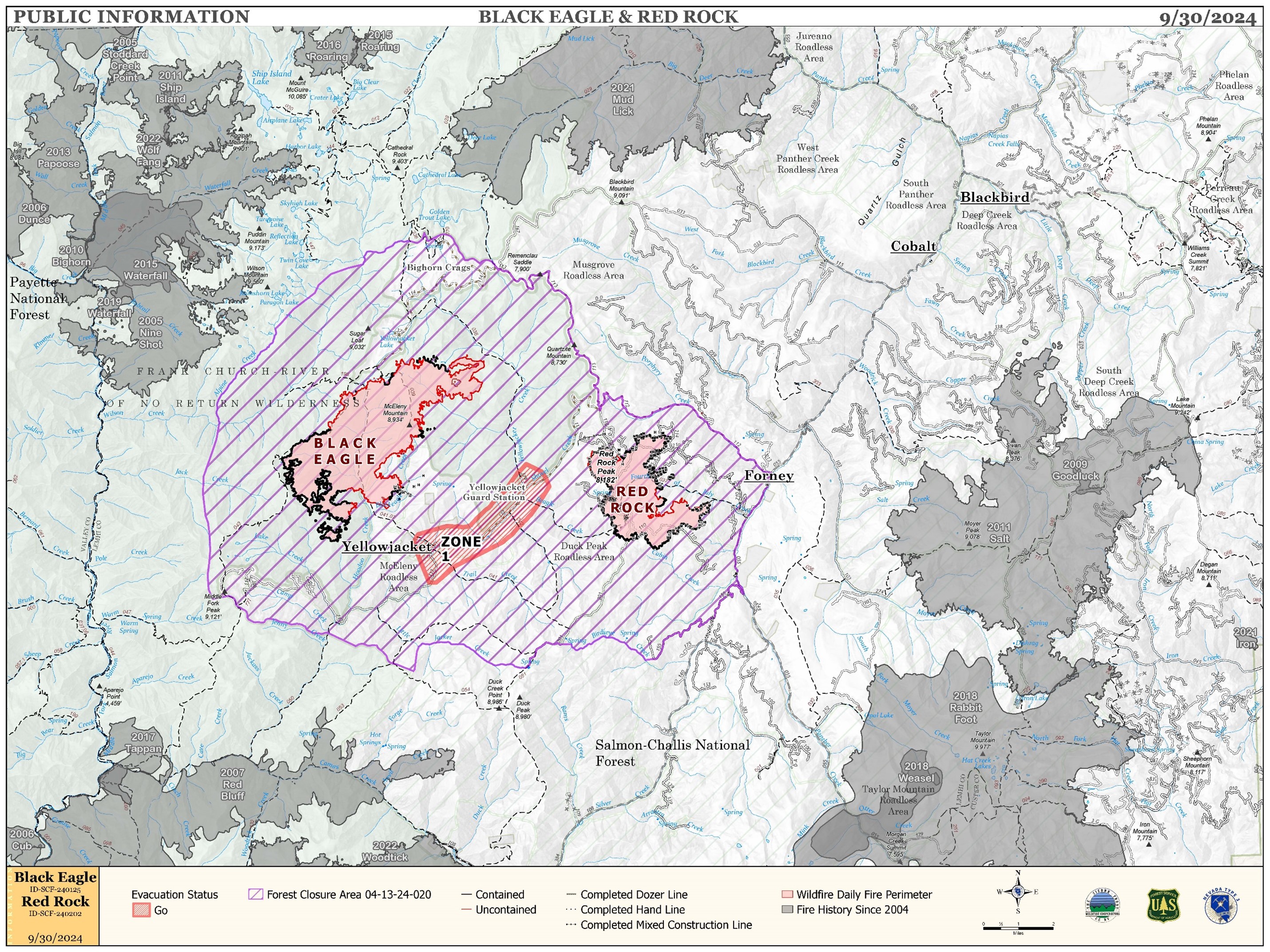
The Red Rock Fire is at 3,277 acres and 75% containment.
Poor overnight humidity recovery and gusty winds led to an active day of fire activity yesterday. Fire behavior increased throughout the day as winds steadily increased and RH dropped into the upper teens. The fire spotted across Fourth of July Creek but crews were able to contain the spot. The southwest winds tested the uncontained line on the eastern edge as those drainages were in direct alignment. Aircraft use was needed to maintain control in areas of increased activity, although winds limited full use of those assets.
The Black Eagle Fire is at 7,313 acres and 8% containment.
The Black Eagle Fire also increased throughout the day as winds steadily increased and humidity dropped to 15-20%. Westerly winds continued to test the northeast area of the fire as heavy fuels were in alignment with the winds and fire backed slowly down towards Yellow Jacket Creek. Use of aircraft was needed to maintain control in areas of increased activity, although winds limited full use of those assets.
WEATHER:
The front that moved over the incident Sunday brought cool, dry air to the area. Today’s temperatures will be 10 degrees cooler than Sunday and humidity will struggle to reach 14%. Winds will be much lighter today as high pressure builds into the area. No precipitation is expected through the next six days.
FIRE BEHAVIOR:
Nearly all fuels are available across both fires, though heavy dead and down fuels remain most problematic for firefighters. Areas where humidities fall below 25% with gusty afternoon winds can experience increased activity, including short-range spotting. Opportunities to attack the fire directly will likely be confined to morning hours and when effective water support is available.
FOREST CLOSURES: For forest closure information please go to: https://www.fs.usda.gov/alerts/scnf/alerts-notices
EVACUATIONS: For evacuation information in Lemhi County regarding these fires please go to: Emergency Management Department | Lemhi County, ID (lemhicountyidaho.org).
Elk Fire Daily Update Monday September 30 2024 09 30 2024
Related Incident: Elk Fire 2024
Publication Type: News
Wyoming Type III Team, Incident Commander: Matt Weakland
Location: Approximately 6 miles northwest of Dayton, Wyoming
Start Date: Friday, September 27, 2024
Cause: Lightning
Size: (6,312 acres night of September 29) The fire grew at least 8 miles to the south overnight. Maps will be posted once data is available.
Percent contained: 0%
Resources: 7 Hand Crews; 3 Engines; 3 Heavy Equipment; 2 type 1 Helicopters, 1 type 2 Helicopter , 1 air attack, air tankers as available.
FIRE STATUS:
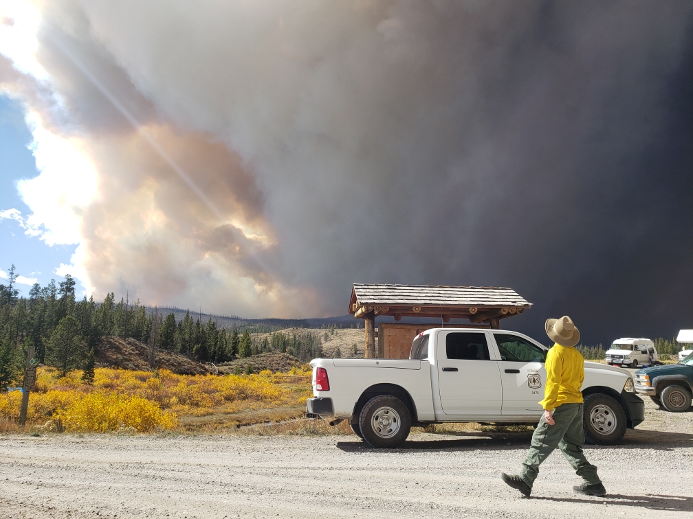
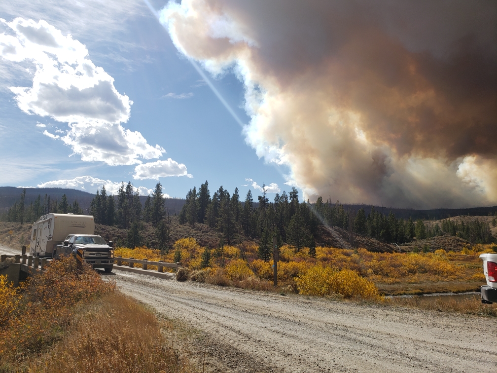
Yesterday, the fire significantly increased in size. All air operations were put on hold for several hours due to high winds. Evacuations were issued along Pass Creek and Sheridan County Road 144, Pass Creek is closed to all non-resident traffic.
As of the morning of September 30, out-building structures have likely been lost. Local Law enforcement and firefighters are working with the Sheridan County Sheriff’s Office to notify property owners of structures lost.
Fire crews will focus on working to protect structures along the face of the mountain in the Pass Creek, Smith Creek, and Twin Creek areas. Thank you to Sheridan County Fire for structure protection work all throughout the night of September 29 and early morning of September 30.
A Complex Incident Management Team has been ordered to take over command of the fire. Wyoming Type III will remain in place until a transition can occur.
The objective is to protect critical values at risk. These values include firefighter and public safety, lands and property off National Forest Lands, two cow camps and a radio repeater site.
The strategy is full suppression. The team is utilizing all available tactics with firefighter and public safety as the primary decision driver. The approach to suppress the fire will be conducive to the terrain, conditions, and medical team response time.
WEATHER AND FIRE BEHAVIOR:
The weather is expected to change with much cooler day and night temperatures today. Wind direction is forecasted to change.
AIR QUALITY AND SMOKE:
It is expected that the fire will continue to put up a smoke column, please check the AirNow website at https://www.airnow.gov/ to monitor smoke movement.
CLOSURES:
A closure order is in effect to protect the safety of firefighters and the public. An area including, Forest System Roads 145,150, 114, and portions of 167 and 168 along with Forest System Trails 201, 077, and 428 will be closed to public entry.
Sheridan County has closed Pass Creek Road, Twin Creek, Smith Creek Road, and Tongue River Canyon Road to non-resident travel.
Residences have been evacuated. Law enforcement and fire personnel are contacting affected people directly. If people need shelter for livestock or themselves, please call Sheridan County Emergency Management at 307-752-2174.
This order is being put in place to protect firefighter and visitor safety. The roads are being heavily used by firefighters, including large equipment. If you can, please avoid travel in the general area. If you need to remove personal equipment from the closure area or roads behind it, please contact 307-683-7019.
Morning Update Frog Fire Monday 09 30 2024
Related Incident: Frog
Publication Type: News
Frog Fire Statistics
- Size: 3,113 acres
- Containment: 66%
- Total Personnel: 81
- Location: east of Clayton, ID
- Reported: September 7, 2024
- Cause: Lightning
For More Information
InciWeb: https://inciweb.wildfire.gov/incident-information/idstf-frog
Facebook: https://www.facebook.com/sawtoothnationalforest
Current Situation: Despite the gusty winds yesterday, the Frog Fire held in its current footprint, with
an increase of just one acre. Good progress was made by helicopters dropping water on the west side.
While increased fire activity on the west side created more smoke than has been seen in the area in
several days, the flames were from unburned vegetation interior to the fire perimeter. Crews kept a
careful eye on the southern edge of the fire, but no significant spread was reported. This plan will
continue today with helicopters on standby in case they are needed. Resources will continue to be
reassigned from the Frog Fire to the Wapiti Fire today as well.
Evacuations: There are currently no evacuations related to the Frog Fire.
Closures: The area closure in place around the Frog Fire includes FS 667 (Big Boulder Creek Road)
and Trail 047 where adjacent to the closure boundary. The closure excludes FS Roads 669 and 670
and Trail 682. Hunters and recreationalists should familiarize themselves with this closure
information prior to entering the vicinity. Please reference the map and read the full closure
description at https://inciweb.wildfire.gov/incident-closures/idstf-frog.
Middle Fork Complex Daily Update Sept 30th 2024 09 30 2024
Related Incident:
Publication Type: News
Middle Fork Complex: 61,484 acres, 90% completion, 400 Personnel
Snag Fire: 33,436 acres, 90% completion, 41 Personnel
Goat Fire: 27,131 acres, 46% completion, 41 personnel
As the cold front moved on Sunday so did a slight increase in winds in the fire area as a result more smoke was visible then in previous days. As cooler temperatures over night start to subside in the morning we can expect relative humidities to fall from 15 to the 30th percentile. The drying trend is expected to continue throughout the day. We can expect more smoke to be visible as more fuels become available in the fire’s interior.
Middle Fork Complex – Suppression repair will continue in the Deadwood Reservoir. As heavy equipment continues to work in the area and more closures are lifted, please use extra caution when traveling in any areas nearby. Engine crews will also remain in the area continuing to check and solidify any containment lines and evaluate confinement lines.
Goat – Crews have completed most of the repair work around Clear Creek and will continue suppression repair in the private lands near Clear Creek. Hand crews will increase the depth of their mop up efforts along the containment lines. Engine companies and crews will continue to evaluate and protect confinement lines in the Northeast corner.
Snag – Suppression repair will continue across the fire area with the primary focus on hand and dozer lines. Evaluation and strengthening of containment lines will continue along the western side of the fire. Significant work is also going into suppression repair of many of the access roads used by fire personnel in all areas. This will be the final update from Great Basin Team 2. It has been the Garden Valley Community and surrounding areas.
Middle Fork Complex - Suppression Repair= 28 miles of handline completed. 13 miles of dozer line completed.
Goat and Snag Fires - Suppression Repair = 16 miles of handline completed. 7 miles of dozer line completed.
Firefighters continue work both fire suppression and suppression repair as needed so heavy firefighting equipment is moving from site to site. Please use extreme caution while traveling, especially when approaching vehicles, and at intersections.
Closure Orders: https://www.fs.usda.gov/alerts/boise/alerts-notices
Hunters are not allowed access to closed areas. We ask the public to adhere to the closures as they currently exist; in particular, Trail Creek Hot Springs is currently within the closure area for the West Mountain Complex and is closed.
Fire Restrictions: Stage 1 Fire Restrictions have been rescinded for the Boise National Forest. For more information on the restrictions visit https://www.fs.usda.gov/alerts/boise/alerts-notices.
Morning Update Wapiti Fire Monday 09 30 2024
Related Incident:
Publication Type: News
Wapiti Fire Statistics
- Size: 125,624 acres
- Completion: 75%
- Total Personnel: 344
- Location: near Grandjean, ID
- Reported: July 24, 2024
- Cause: Lightning
For More Information
- InciWeb: https://inciweb.wildfire.gov/incident-information/idbof-wapiti-fire
- Facebook: https://www.facebook.com/wapitifireinfo2024
- Linktree: https://linktr.ee/WapitiFireInfo2024
- Interactive Map: https://tinyurl.com/WapitiFireInfoMap
Special Emphasis: Collection of firewood within the closure areas is prohibited; any firewood collection in open areas must be done with a valid firewood permit. For questions on firewood collection on the Sawtooth National Forest, please contact the Stanley Ranger Station at 208.774.3000.
Weather: Gusty winds continued in the fire area yesterday with slightly lower temperatures. These winds have brought very cold weather in the 15-20 degree range this morning, returning the area to a trend of more seasonal temperatures. Winds are expected to calm down today. Less wind and slightly cooler temperatures will allow crews to make good progress on the Wapiti Fire.
Dry conditions will continue in the fire area for the next several days. “The 5% chance of rain later in the week is a very slight - wishing and crossing your fingers - kind of chance,” said John Keyes, Incident Meteorologist.
Current Situation: The increase in acreage of the Wapiti Fire is spread around the entire fire area and is not indicative of a significant increase in activity. The eastern portion of the Wapiti Fire was less active yesterday and fire activity is expected to decrease further as the winds calm down; there is no significant threat of fire spread today. Crews continued to patrol Highway 21 and areas where hot spots remain by Bull Trout Lake, Copper Mountain, and Cape Horn. Helicopter crews dropped water north of Copper Mountain into the afternoon, as long as wind conditions allowed yesterday. This work, as well as the work digging fireline around Cape Horn, will continue today. Firefighters will take full advantage of the cooler temperatures and calmer winds to make progress on the remaining heat on the Wapiti Fire.
Most of the repair work on the east side of the fire was completed yesterday, and repair on the west side will be concluded soon. The bulk of resources working on the east side of the fire have been freed up to assist with the repair of Grandjean Road. The repair of Grandjean Road still has several days of work left, ensuring time is taken to make the right decisions to complete repair in the most effective way possible. Felling hazard trees on Road 630 will continue today.
Evacuations: Evacuation status for Stanley Zone 1 is currently at READY. Stanley Zones 2 – 5 and Kasino are no longer in an evacuation status. Sign up for Custer County CodeRED emergency notifications: text CUSTER to 99411 or enroll at https://public.coderedweb.com/CNE/BF28E45537FF.
All Boise County evacuation levels have been lifted; residents should remain alert for any change in conditions which could reinitiate an evacuation status. Sign up for Boise County Alert Sense emergency notifications at https://public.alertsense.com/SignUp/publicUser.aspx?regionid=1163.
For evacuation information on the Wapiti Fire, please see the Custer County Sheriff’s Facebook page, https://www.facebook.com/p/Custer-County-Sheriff-Idaho-61558947312289/, and the Boise County Sheriff’s Facebook page, https://www.facebook.com/boisecountysheriff/.
Closures: The Wapiti Fire area closure covers portions of the Sawtooth, Boise, and Salmon-Challis National Forests. Please reference the map and description at https://inciweb.wildfire.gov/incident-closures/idbof-wapiti-fire. Recreationalists and hunters should reference this map and obey all posted signage regarding the closure area and any related road, trail, and campground closures.
An interactive map for all closures on the Boise National Forest is found at https://experience.arcgis.com/experience/642380b0eb124c8cab6bd9ad3d7146ad/page/Overview/#data_s=id%3AdataSource_5-1888bd00a2c-layer-13-1888bd00b53-layer-16%3A82
ALERT EMERGENCY CLOSURE US Hwy 26287 09 29 2024
Related Incident:
Publication Type: Announcement
UPDATE: 9/29/24 at 4:25pm - WYDOT has reopened US Hwy 26/287
ALERT: Highway 26/287 is under emergency closure due to #FishCreek and #PackTrail fires. See WYDOT Teton County and https://map.wyoroad.info/wtimap/index.html for up to date information. Estimated reopening time is unknown.
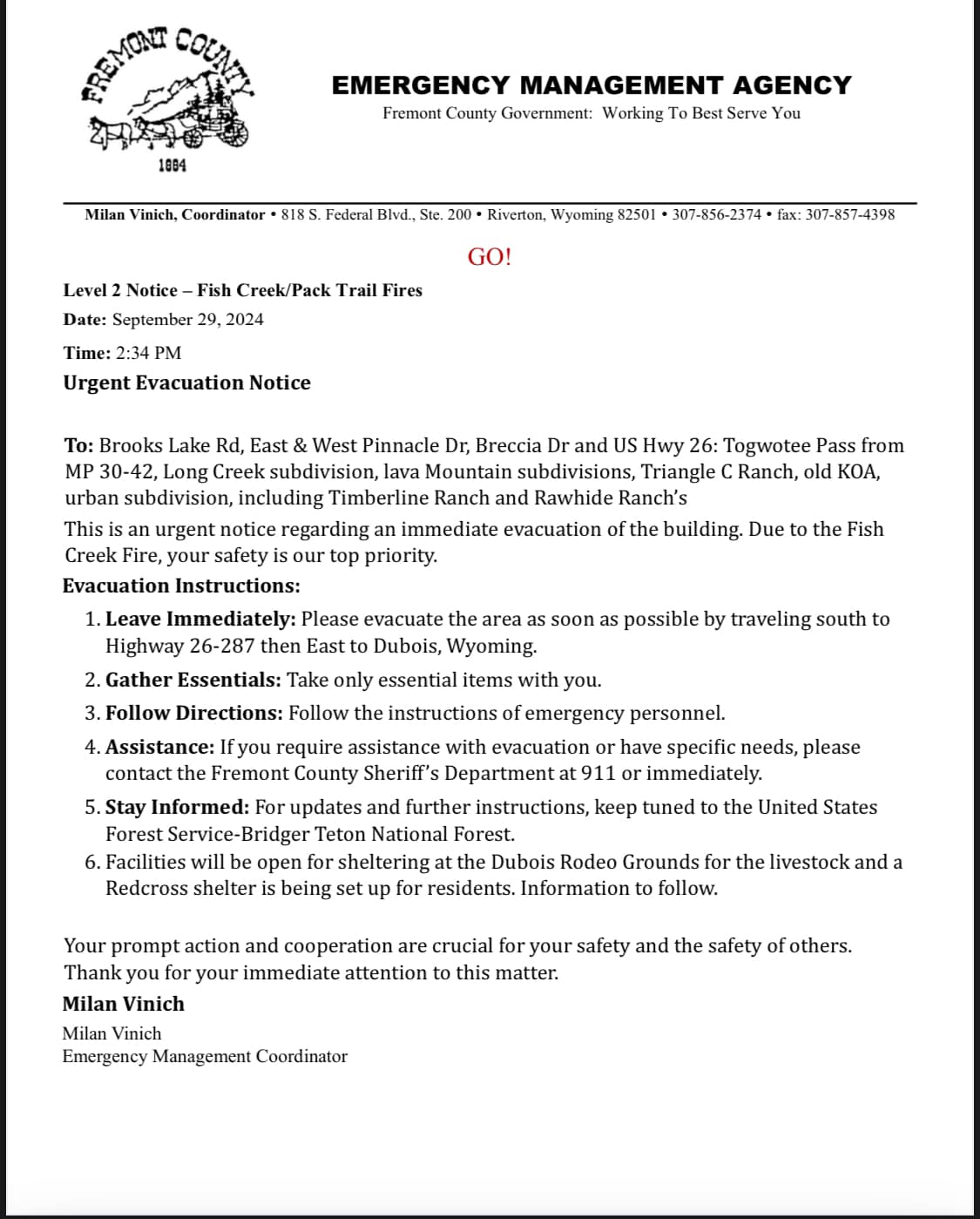
EVACUATION GO Fremont County 09 29 2024
Related Incident:
Publication Type: Announcement
GO!!!!! EVACUATE IMMEDIATELY.
Fremont County - Wyoming - Emergency Management Agency has issued IMMEDIATE evacuation for the following due to the Pack Trail and Fish Creek Fires.
Brooks Lake Road, East & West Pinnacle Drive, Breccia Drive, US HWY 26: Togwotee Pass from Mile Post 30-44, Long Creek Subdivision, Lava Mountain Subdivisions, Triangle C Ranch, old KOA, Bourban subdivision, including Timberline Ranch and Rawhide Ranches.
Immediate Evacuation Required. Extreme winds and fire behavior have caused extreme fire behavior and rapid fire movement to these developments.
Wood Lake Fire CLosure Order 09092407 Updated Exhibit BEffective September 28 2024 09 28 2024
Related Incident:
Publication Type: Closures
Emergency Closure Order 09092407 Updated Exhibit AList of Closed AreasEffective Sept 28 2024 09 28 2024
Related Incident:
Publication Type: Closures
Updated EMERGENCY CLOSURE ORDER 09-09-24-07-Effective September 28, 2024
Pursuant to the provisions of 16 U.S.C. § 551, and 36 C.F.R. §§ 261.50 (a) and (b), the following acts are prohibited in the Superior National Forest, due to hazards on portions of lands within Boundary Waters Canoe Area Wilderness (BWCAW) and trails in Lake County, Northeastern Minnesota. These restrictions go into effect at 12:01 a.m. CT on Tuesday, September 28, 2024.
The following areas are restricted:
- Northeast section of Wood Lake- The area within the Wood Lake Fire perimeter.
Updated Wood Lake Fire Closure Area Press ReleaseEffective September 28 2024 09 28 2024
Related Incident:
Publication Type: Closures
Superior National Forest Updates Closure Area for Wood Lake Wildfire Within the Boundary Waters Canoe Area Wilderness
New exhibits for Closure Order 09-09-24-07 showing the extent of the closure effective September 28, 12:01am CT.
Duluth, MN. September 16, 2024 — The Superior National Forest is updating the closure areas under Emergency Forest Closure Order 09-09-24-07 established for the Wood Lake Fire, beginning on Saturday, September 28, 2024, at 12:01 a.m., within the Boundary Waters Canoe Area Wilderness (BWCAW). The adjusted Exhibit A-List of Closed Areas and Exhibit B-Closure Map, have removed the following recreation areas from the closed area:
BWCAW points of entry:
- #26 Wood Lake
Lakes: - Hula Lake
- Good Lake
- Indiana Lake
Portages: - Wood Lake Entry Point Parking Lot to Wood Lake
- Wood Lake to Hula Lake
- Hula Lake to Good Lake
- Good Lake to Good Creek
- Good Lake to Hoist Bay (Basswood Lake)
- Good Lake to Indiana Lake
- Indiana Lake to Basswood Lake
- Indiana Lake to Wind Bay Creek (Wind Bay, Basswood Lake)
The Forest Order closures include the area within the Wood Lake Fire perimeter on the northeastern section of Wood Lake – see Exhibits for details.
The Forest Service has notified permit holders, cooperators and outfitters of the closure change. This emergency closure is necessary for the safety of our visitors, our wilderness rangers and our firefighters.
The Wood Lake fire, as of today, is 50% contained and at 27 acres. Please see the inciweb page for future updates: Mnsuf Wood Lake Fire Information | InciWeb (wildfire.gov)
Northern Minnesota continues to experience drought conditions, causing active and increasing fire across the landscape. Forest staff are monitoring the Wood Lake Fire with additional resources on standby. Visitors to the area may see smoke in the area. There is no need to report this unless it’s outside the closure area.
Beyond the closures for the Wood Lake Fire, the Forest is open to the public and no other restrictions apply.
Frequently Asked Questions
Q. Why is there going to be a closure for such a small wildfire?
A. A closure order is needed to prioritize safety: Firefighter and public safety are the top priorities. Superior National Forest (NF) management also considered other factors that determined the need for a necessary closure order including above average temperatures, forest drought conditions, extended forecast conditions, availability of firefighting resources, and vegetative fuel conditions in and around the fire area. In addition, the fire is in a unique area of the Forest – a designated Wilderness, which is managed differently.
Q. Which areas are affected by this Closure order?
A. The following areas are restricted:
Lakes: Fire perimeter area on NE Wood Lake
See closure order and map for more information.
Q. How long will the closure be in place?
A. Public lands closures help to reduce interference with emergency crews and allow for fire suppression and burned area recovery. The original Forest Closure Order was effective September 12,2024, updated September 17, 2024, and again September 27, 2024. The order will remain in effect until the fire is declared out, unless sooner rescinded. The Superior NF wants to express gratitude for the public's patience as we work to reopen these special places as quickly as safely possible.
Please remain vigilant while out on your public lands. Fuel conditions remain very dry and new fire starts are possible. Help us thank firefighters, and protect your community from new, human-caused fires.
Q. How do I find more information about the Wood Lake Wildfire?
A. Go to Inciweb for this incident can be found at: https://inciweb.wildfire.gov/incident-information/mnsuf-wood-lake-fire. You will find information on other wildfires on this website as well.
Q. How many campsites will be affected by this closure on the BWCAW? Does this closure impact any points of entry?
A. There are not currently any campsites affected by the closure.
The Wood Lake (#26) point of entry is no longer affected by the closure. We still encourage people to seek alternate locations for your visit, either on the BWCAW or at any of the 23 developed campgrounds and 18 rustic campgrounds. There are 254 backcountry campsites outside the wilderness that offer remote paddling, camping and fishing. Here you can experience solitude without reservations, fees or permits and have similar amenities that you would find in a Wilderness campsite. Many backcountry campsites are located on canoe routes outside the BWCAW. State forests and parks and county lands are also available for recreation.
Q. Can I fly a recreational drone over the wildfire to take photos?
A. No, flying drones or Unmanned Aircraft Systems (UAS) within or near a wildfire without permission could cause injury or death to firefighters and hamper their ability to protect lives, property, and natural cultural resources. In addition, drones are prohibited from launching, landing or being controlled from within designated wilderness areas.
Individuals who fly UAS without authorization over wildfires may be violating federal, state, and/or local laws, regulations, and ordinances, whether a Temporary Flight Restriction (TFR) is in place or not. All unauthorized UAS flights over wildfires on National Forest System lands will be reported to the Federal Aviation Administration (FAA) and law enforcement agencies.
Individuals who have been determined to have endangered manned aircraft or people on the ground with a UAS and/or interfered with wildfire suppression may be subject to civil penalties, including fines of up to $25,000, and potentially criminal prosecution. Drones are not legal within federally designated wilderness areas nationwide.
Q. What does it mean by the Forest Service is using Full Suppression tactics for this wildfire?
A. The Forest Service is using a full suppression approach. By Forest Service policy, every fire receives a strategic, risk-based response appropriate for the circumstances and associated threats and opportunities. Each strategy uses the full spectrum of management actions that consider fire and fuel conditions, weather, values at risk and resource availability.
Fire danger is high from Duluth through Arrowhead due to drought conditions and above normal warm weather. Fire danger is likely to remain high for the next few weeks. In addition to the weather conditions, this area includes high fuel loads, due to spruce budworm affected trees – both standing and laying down that can increase fire behavior.
Q. How is the current air quality situation affecting wildfire operations?
A. Canadian wildfires are contributing to some decreased air quality conditions across northern and central Minnesota. Air quality is currently GOOD for the Ely area. For more information on air quality where you live, see. https://www.airnow.gov/
Safety is our number one priority and, in some instances, aviation resources like planes, helicopters, etc. may not be used in suppressing a fire because of continued air pollution from Canadian wildfires.
There are 254 backcountry campsites outside the Wilderness that offer remote paddling, camping and fishing. Here you can experience solitude without reservations, fees or permits and still have similar amenities to that of a BWCAW campsite. Many backcountry campsites are located on canoe routes outside the BWCAW. State forests and parks and county lands are also available for recreation.
For more information on recreation alternatives outside the BWCAW, please visit: Superior National Forest - Water Activities:Boating - Non-Motorized (usda.gov) For a list of canoe routes with backcountry campsites in the Superior National Forest, visit: Canoeing 2012 rev 0415 final.pub (usda.gov)
The Superior National Forest also offers 23 developed campgrounds and 18 rustic campgrounds. Rustic campgrounds are free of charge and available first come, first served year-round. Fee campgrounds are open May – September and may be reserved at Recreation.gov. See the Forest website for more information.
For additional information regarding fire-related and/or forest closures and updates:
• Inciweb for this incident can be found at https://inciweb.wildfire.gov/incident-information/mnsuf-wood-lake-fire.
• SNF Forest Orders
• Superior National Forest general fire information: https://www.fs.usda.gov/main/superior/fire
• To sign up for our Superior NF newsletter and news, including fire information: https://www.fs.usda.gov/detail/superior/home/?cid=FSEPRD1115779