
Incident Publication
Line PostFire BAER Soil Burn Severity Map Released 09 27 2024
Related Incident: Southern California Post-Fire BAER 2024
Publication Type: News
Line Post-Fire BAER Soil Burn Severity Map Released
September 27, 2024
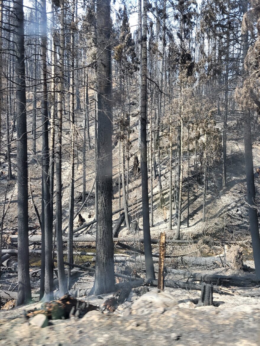
USDA Forest Service Burned Area Emergency Response (BAER) specialists recently completed their data gathering and analysis for the Line Fire burned area to produce a post-fire Soil Burn Severity (SBS) map.
The BAER SBS map and data display categories of unburned/very low, low, moderate, and high soil burn severity in different colors for the different categories. Approximately 30% of the 39,234 acres analyzed by the BAER team are either unburned/very low or low soil burn severity, while 51% sustained a moderate soil burn severity, and about 19% were identified as having high soil burn severity.
The BAER assessment team used initial remote sensing imagery with their field-validated soils data, to develop and produce a map showing soil burn severity levels for the burned area. The SBS is broken into four different classes: unburned/very low (green), low (blue), moderate (yellow), and high (red). For more information on these different SBS classifications, see the BAER Information Brief at: Cabdf Southern California Postfire Baer 2024 - | InciWeb (wildfire.gov).
There are several types of fire severity and intensity maps that you may see. Although they look different for the same fire, they may also all be accurate. This is because fire severity or intensity are different measures of the fire effects on a specific resource such as soils, tree canopies, vegetation or wildlife habitat. Burned Area Emergency Response (BAER) maps are primarily measures of fire effects on soils.
The BAER team relies on their final soil burn severity map to produce data, which they are using in their subsequent modeling and determination of post-fire runoff, erosion, and sedimentation. The BAER team, the US Geological Survey (USGS), and the California State Watershed Emergency Response Team (WERT) all utilize the soil burn severity map as an analysis tool to estimate post-fire watershed response to precipitation events. In specific areas that experienced moderate to high burn severity, there could be increased runoff from steep hillslopes which could result in increases of post-fire soil erosion, sedimentation, and potential debris flows.
The Line Fire SBS map can be downloaded at the Line Post-Fire BAER InciWeb site: Cabdf Southern California Postfire Baer 2024 Information | InciWeb (wildfire.gov) under the “Maps” tab.
BAER SAFETY MESSAGE: Everyone near and downstream from the burned areas should remain alert and stay updated on weather conditions that may result in heavy rains and increased water runoff. Flash flooding may occur quickly during heavy rain events--be prepared to act. Current weather and emergency notifications can be found at the National Weather Service website: www.weather.gov/lox/.
###
Firefighters treat 758 acres at West Dolores Rim prescribed burn units in two days 09 27 2024
Related Incident:
Publication Type: Announcement
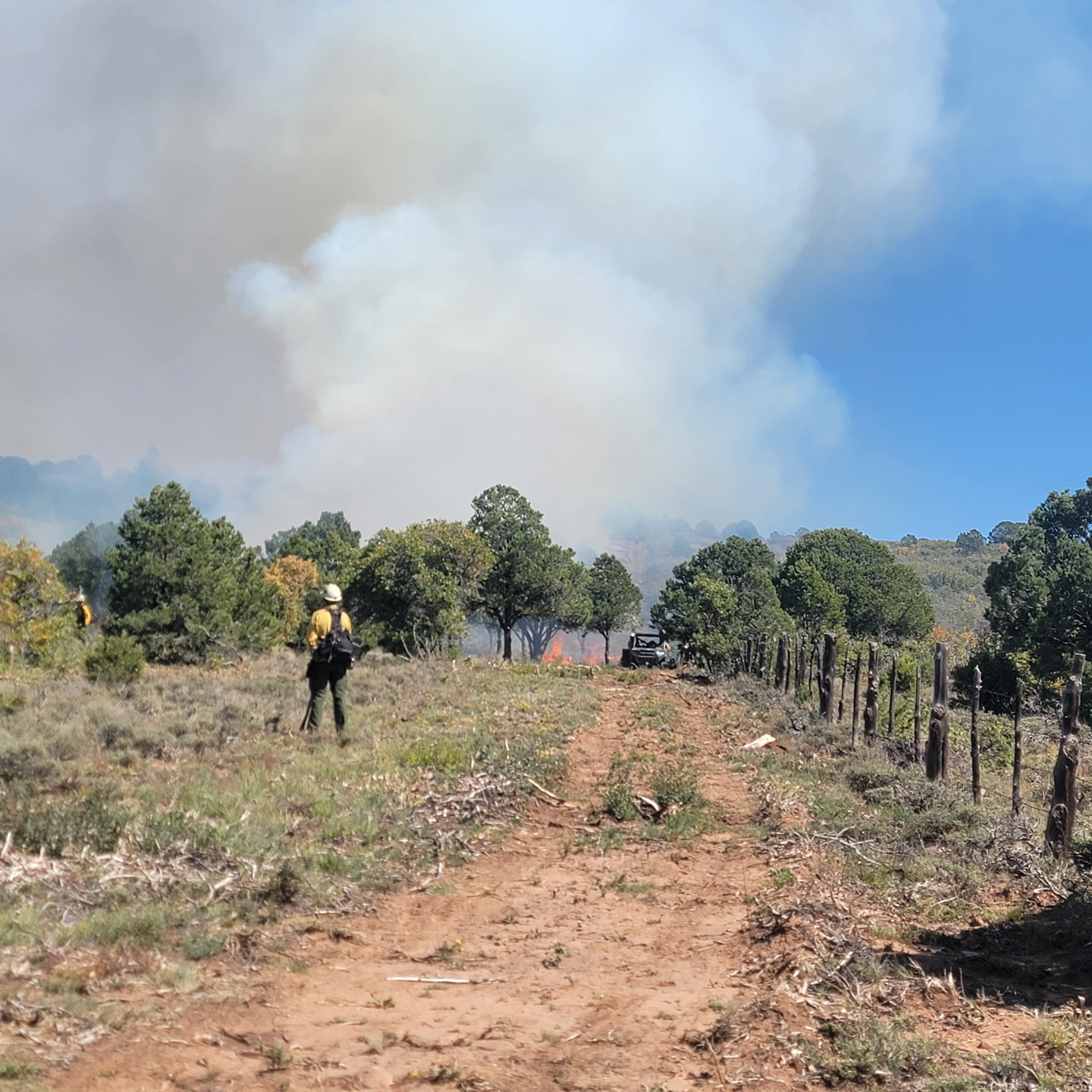
A combination of federal and state firefighters on the BLM West Dolores Rim prescribed burn had another great day of burning. They treated 124 acres in Unit 20A, bringing the total to 758 acres accomplished in the last two days. Fire resources will monitor units in the following days. Smoke is expected to be visible from US-491 and CO-141 throughout the weekend and possible into next week as vegetation in the interior continues to smolder. Smoke may settle into low lying areas overnight. Both burn units are roughly located north, northeast of Dove Creek, CO.
For information on prescribed burns, follow us on Twitter https://twitter.com/SWD_Fire and Facebook http://www.facebook.com/BLMMontroseFireUnit.
Public Firewood Gathering Opportunity at Togwotee Lodge 09 27 2024
Related Incident:
Publication Type: News
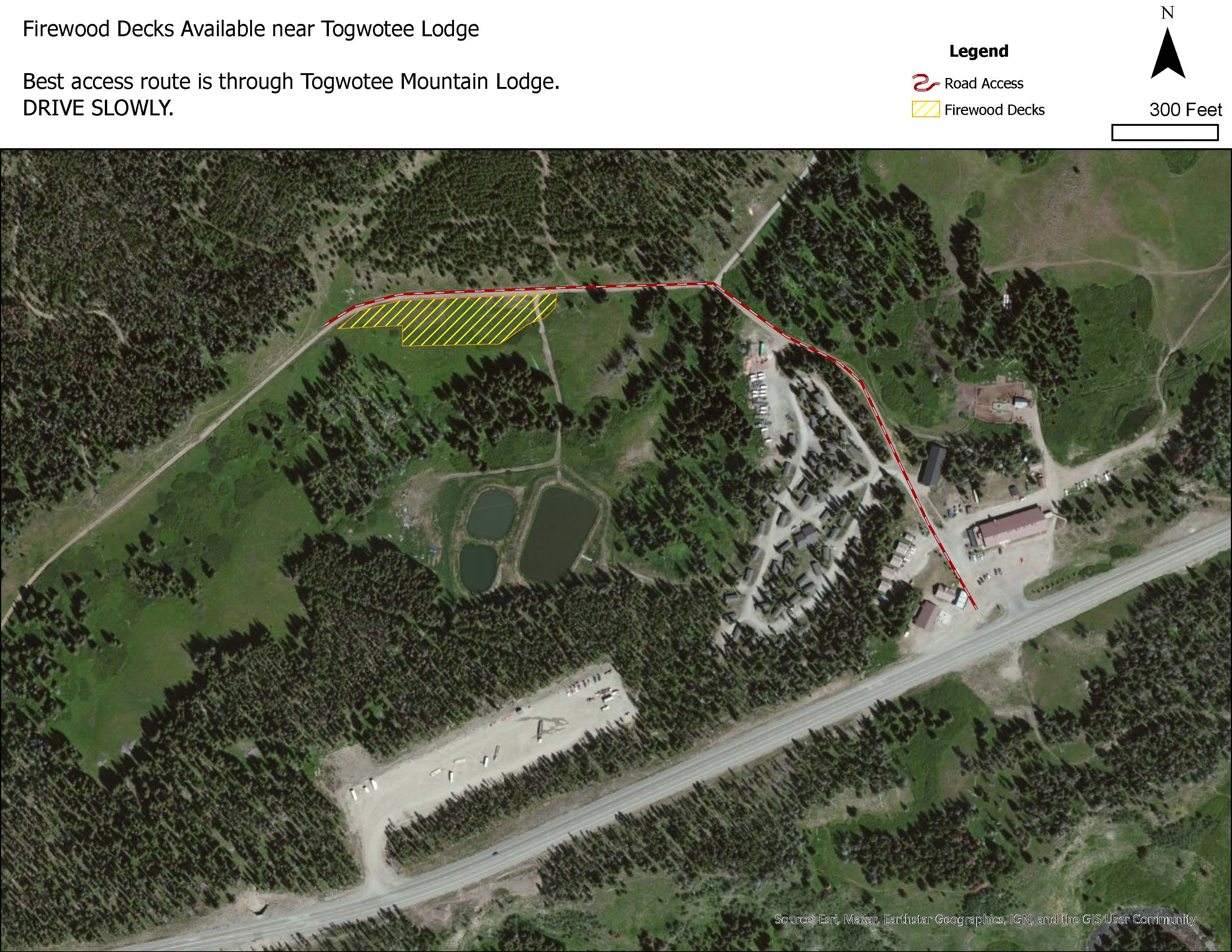
Moran Wyo., September 27, 2024– Approximately 700 cords of firewood located at Togwotee Lodge are stacked in log decks from the Fish Creek Fire suppression operations and are available to the public for firewood gathering with a permit. The decks contain Engelmann spruce and some lodge pole pine. They are easily accessible and located off the Togwotee Lodge Road.
A valid, hard copy, personal use fuelwood permit will be required. Wood cutters can take up to 10 cords of firewood per household for personal use under the personal use permit. Normal firewood permit restrictions and requirements will apply. Please do not travel more than 300 feet from any road while gathering the firewood.
These decks, or piles of logs exceeding 10-feet in length, were formed from fire suppression activities and the logs are full length. The Bridger-Teton reminds firewood gatherers that fuel wood permits only allow logs of 8-feet or less to be removed. This means one will still have to buck the logs into the appropriate lengths prior to leaving the area.
Woodcutters should exercise caution when cutting from decks, and please be courteous and respectful of other woodcutters. As access to the area is through a mountain resort area, woodcutters are asked to be respectful of the nearby business and exercise extreme caution while driving on the road. Togwotee lodge closes for the season on Tuesday, October 1, and no services will be available at the lodge.
There are multiple decks in the area of the Fish Creek Fire and some are available to the public for fuelwood, and others are not yet ready because fire personnel are still stacking wood. The firewood that is available from the Fish Creek Fire is only the wood in the Togwotee Lodge area. The Shoshone National Forest and the Bridger-Teton National Forest will be issuing subsequent public notice as additional wood piles become available.
The permit is for personal-use firewood only, not for resale. No commercial permits are available. Firewood permits cost $7.00 per cord, with a minimum purchase of five cords, for $35.00. A cord is the amount of wood in a stack 4-feet wide, 4-feet high and 8- feet long. Permits are valid through the calendar year and can be purchased 8 a.m. to 4:30 p.m. Monday through Friday at the Blackrock Ranger District Office, 20250 US-26 #287, Moran, WY 83013. The office is closed on holidays and weekends. For more information, call 307-543-2386.
As the wood is no longer in the operational area of fire suppression activities, contact the Bridger-Teton National Forest with any questions at 307-739-5500. In the event of emergency, dial 911 for local response. For other news, events and information visit https://www.fs.usda.gov/btnf or follow the Bridger-Teton National Forest on Facebook @BridgerTetonNF or on X (formerly Twitter) @BridgerTetonNF.
USDA is an equal opportunity provider, employer and lender.
###
Line Fire Daily Update for 09 27 2024
Related Incident: Line Fire
Publication Type: News
Line Fire Fact Sheet
27 September 2024
Fire Status
Acres: 39,299 Containment: 83%
Firefighting Resources
Engines: 50
Crews: 23
Water Tenders: 12
Dozers: 23
Helicopters: 5
Other: 37
Total Personnel: 1,131
Structures Damaged: 4 Structures Destroyed: 1
Firefighter Injuries: 4Yesterday, the Line Fire actively burned within containment lines in Bear Creek. The fire burned up this very steep drainage to the strategically placed indirect containment lines. It was this burning vegetation that produced the smoke yesterday afternoon. The fire remains within the containment lines.
The fire grew by a few additional acres in the Santa Ana river drainage with roll-outs and small runs upslope. This area is well staffed with firefighters.
Temperatures are expected to remain the same as yesterday, with the highs ranging from the mid 70’s to the mid 80’s. Relatively humidity will be in the 15-25% range with winds gusting around 15 MPH in the afternoon.
California Complex Incident Management Team 11 is now managing the fire for the San Bernardino National Forest.
Highway 330 remains closed due to fire damage.
Red Fire Daily Update for Friday 09 27 2024
Related Incident: Red Fire
Publication Type: News
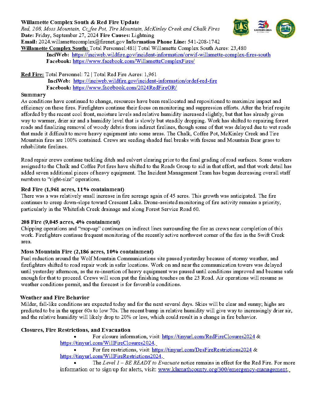
Willamette Complex South & Red Fire Update
Red, 208, Moss Mountain, Coffee Pot, Tire Mountain, McKinley Creek and Chalk Fires
Date: Friday, September 27, 2024
Fire Causes: Lightning
Email: 2024.willamettecomplex@firenet.gov Information
Phone Line: 541-208-1742
Willamette Complex South: Total Personnel:481| Total Willamette Complex South Acres: 23,480
InciWeb: https://inciweb.wildfire.gov/incident-information/orwif-willamette-complex-fires-south Facebook: https://www.facebook.com/WillametteComplexFires/
Red Fire: Total Personnel: 72 | Total Red Fire Acres: 1,961
InciWeb: https://inciweb.wildfire.gov/incident-information/ordef-red-fire Facebook: https://www.facebook.com/2024RedFireOR/
Summary
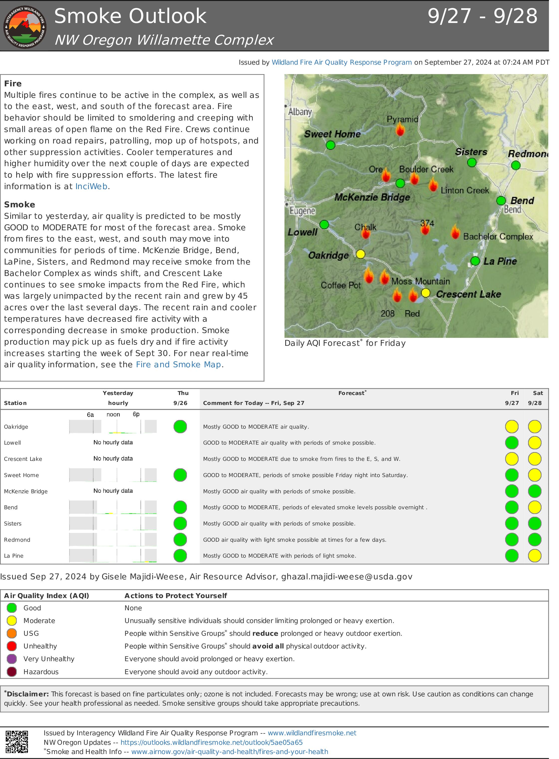
As conditions have continued to change, resources have been reallocated and repositioned to maximize impact and efficiency on these fires. Firefighters continue their focus on monitoring and suppression efforts. After the brief respite afforded by the recent cool front, moisture levels and relative humidity increased slightly, but that has already given way to warmer, drier air and a humidity level that is slowly but steadily dropping. Work has shifted to repairing forest roads and finalizing removal of woody debris from indirect firelines, though some of that was delayed due to wet roads that made it difficult to move heavy equipment into some areas. The Chalk, Coffee Pot, McKinley Creek and Tire Mountain fires are 100% contained. Crews are seeding shaded fuel breaks with fescue and Mountain Bear grass to rehabilitate firelines.
Road repair crews continue tackling ditch and culvert clearing prior to the final grading of road surfaces. Some workers assigned to the Chalk and Coffee Pot fires have shifted to the Roads Group to aid in that effort, and that work detail has added seven additional pieces of heavy equipment. The Incident Management Team has begun decreasing overall staff numbers to “right-size” operations.
Red Fire (1,961 acres, 11% containment)
There was a was relatively small increase in fire acreage again of 45 acres. This growth was anticipated. The fire continues to creep down-slope toward Crescent Lake. Drone-assisted monitoring of fire activity remains a priority, particularly in the Whitefish Creek drainage and along Forest Service Road 60.
208 Fire (9,045 acres, 4% containment)
Chipping operations and “mop-up” continues on indirect lines surrounding the fire as crews near completion of this work. Firefighters continue frequent monitoring of the recently active northwest corner of the fire in the Swift Creek area.
Moss Mountain Fire (2,186 acres, 10% containment)
Fuel reduction around the Wolf Mountain Communications site paused yesterday because of stormy weather, and firefighters shifted to road repair work in safer locations. Work on and near the communication towers was delayed until yesterday afternoon, as the re-insertion of heavy equipment was paused until conditions improved and became safe enough for that to proceed. Crews will soon put the finishing touches on the 23 Road. Air operations will resume as weather conditions permit, and the forecast is for favorable conditions.
Weather and Fire Behavior
Milder, fall-like conditions are expected today and for the next several days. Skies will be clear and sunny; highs are predicted to be in the upper 60s to low 70s. The recent bump in relative humidity will give way to increasingly drier air, and the relative humidity will likely drop to 20% or less, which could result in a change in fire behavior.
Closures, Fire Restrictions, and Evacuation
For closure information, visit: https://tinyurl.com/RedFireClosures2024 & https://tinyurl.com/WillFireClosures2024.
For fire restrictions, visit: https://tinyurl.com/DesFireRestrictions2024 & https://tinyurl.com/WillFireRestrictions2024.
The Level 1 – BE READY to Evacuate notice remains in effect for the Red Fire. For more information or to sign up for alerts, visit: www.klamathcounty.org/300/emergency-management
Willamette Complex South Daily Update for Friday 09 27 2024
Related Incident: Willamette Complex Fires - South
Publication Type: News
Willamette Complex South & Red Fire Update
Red, 208, Moss Mountain, Coffee Pot, Tire Mountain, McKinley Creek and Chalk Fires
Date: Friday, September 27, 2024
Fire Causes: Lightning
Email: 2024.willamettecomplex@firenet.gov Information
Phone Line: 541-208-1742
Willamette Complex South: Total Personnel:481| Total Willamette Complex South Acres: 23,480
InciWeb: https://inciweb.wildfire.gov/incident-information/orwif-willamette-complex-fires-south Facebook: https://www.facebook.com/WillametteComplexFires/
Red Fire: Total Personnel: 72 | Total Red Fire Acres: 1,961
InciWeb: https://inciweb.wildfire.gov/incident-information/ordef-red-fire Facebook: https://www.facebook.com/2024RedFireOR/
Summary
As conditions have continued to change, resources have been reallocated and repositioned to maximize impact and efficiency on these fires. Firefighters continue their focus on monitoring and suppression efforts. After the brief respite afforded by the recent cool front, moisture levels and relative humidity increased slightly, but that has already given way to warmer, drier air and a humidity level that is slowly but steadily dropping. Work has shifted to repairing forest roads and finalizing removal of woody debris from indirect firelines, though some of that was delayed due to wet roads that made it difficult to move heavy equipment into some areas. The Chalk, Coffee Pot, McKinley Creek and Tire Mountain fires are 100% contained. Crews are seeding shaded fuel breaks with fescue and Mountain Bear grass to rehabilitate firelines.
Road repair crews continue tackling ditch and culvert clearing prior to the final grading of road surfaces. Some workers assigned to the Chalk and Coffee Pot fires have shifted to the Roads Group to aid in that effort, and that work detail has added seven additional pieces of heavy equipment. The Incident Management Team has begun decreasing overall staff numbers to “right-size” operations.
Red Fire (1,961 acres, 11% containment)
There was a was relatively small increase in fire acreage again of 45 acres. This growth was anticipated. The fire continues to creep down-slope toward Crescent Lake. Drone-assisted monitoring of fire activity remains a priority, particularly in the Whitefish Creek drainage and along Forest Service Road 60.
208 Fire (9,045 acres, 4% containment)
Chipping operations and “mop-up” continues on indirect lines surrounding the fire as crews near completion of this work. Firefighters continue frequent monitoring of the recently active northwest corner of the fire in the Swift Creek area.
Moss Mountain Fire (2,186 acres, 10% containment)
Fuel reduction around the Wolf Mountain Communications site paused yesterday because of stormy weather, and firefighters shifted to road repair work in safer locations. Work on and near the communication towers was delayed until yesterday afternoon, as the re-insertion of heavy equipment was paused until conditions improved and became safe enough for that to proceed. Crews will soon put the finishing touches on the 23 Road. Air operations will resume as weather conditions permit, and the forecast is for favorable conditions.
Weather and Fire Behavior
Milder, fall-like conditions are expected today and for the next several days. Skies will be clear and sunny; highs are predicted to be in the upper 60s to low 70s. The recent bump in relative humidity will give way to increasingly drier air, and the relative humidity will likely drop to 20% or less, which could result in a change in fire behavior.
Closures, Fire Restrictions, and Evacuation
For closure information, visit: https://tinyurl.com/RedFireClosures2024 & https://tinyurl.com/WillFireClosures2024.
For fire restrictions, visit: https://tinyurl.com/DesFireRestrictions2024 & https://tinyurl.com/WillFireRestrictions2024.
The Level 1 – BE READY to Evacuate notice remains in effect for the Red Fire. For more information or to sign up for alerts, visit: www.klamathcounty.org/300/emergency-management
HomesteadDiamond Complexes and Lane 1 Fires Daily Update 09 27 2024
Related Incident: Lane 1 Fire
Publication Type: News
Homestead/Diamond Complexes and Lane 1 Fires
Sept. 27, 2024
Fire Information: 541-208-7100, 8 AM - 8 PM
InciWeb-Homestead: https://t.ly/syeHa and InciWeb-Diamond: https://bit.ly/4gCfLsp
As of 6 PM September 26, 2024, seven fires within the Homestead Complex, Lane 1, and Diamond Complex are under active management by Northwest Team 12.
Homestead Complex: 9,958 acres, 35% contained │ Lane 1: 25,951 acres, 99% contained │ Diamond Complex: 11,141 acres, 90% contained │ Total personnel: 757
Crews made great progress in fire suppression repair work on all fires yesterday. Warmer temperatures contributed to a slight uptick in fire behavior on the northwest corner of the Horse Heaven Fire and the southeast side of the Fuller Lake Fire. In addition to two helicopters assigned to the incident, two additional heavy helicopters in the nearby area provided assistance with water drops to successfully keep both fires in check. Firefighters also remain available to assist with new fire starts in the area as needed.
On the Horse Heaven Fire, firefighters are progressing in mop-up and continue to patrol the north side of the fire. Helicopters will remain available for water drops as needed. Masticators, graders, and chippers continue road work on the east side.
The Fuller Lake Fire will continue to back, creep, and smolder in the Boulder Creek Wilderness area. Mastication work is near completion on Forest Service Road 3810. Two additional helicopters with water dropping capabilities are arriving today to provide assistance as needed.
On the Bullpup Fire, numerous roads are still being graded and chipping is continuing. Three engines are patrolling the No Man Fire.
On the Lane 1 Fire, chipping is near completion in the Fairview area and crews are installing water bars as part of dozer line repair work.
Two fires remain uncontained on the Diamond Complex. Crews and heavy equipment on the Potter Fire are continuing to chip and haul away woody debris and engines are actively patrolling for any signs of heat. Road graders continue to repair roads due to increased wear from heavy fire-related traffic. The west and north areas of the Pine Bench Fire are burning within the Boulder Creek Wilderness and may continue to smolder as interior fuels consume.
Closures and fire restrictions: The Umpqua National Forest and the Bureau of Land Management (BLM) have issued revised closure orders. Two closure orders impact the Umpqua National Forest https://t.ly/Mvn6G. A Bureau of Land Management (BLM) Roseburg District closure order is in effect for BLM road(s) 24-1-25 and 24-1-25.1, from the junction with BLM road 24-1-26 (Francis Creek) East to the Roseburg District Boundary in Township 24 South, Range 1, West Section 25. This area will remain closed https://t.ly/uWX6l. A BLM Northwest Oregon District closure west of the Lane 1 fire has been lifted https://t.ly/oW1lG.
Weather: A warming and drying trend has moved into the area with high temperatures into the mid to high 70s through Saturday. Sunday will be cooler, with a return to warm and dry conditions next week.
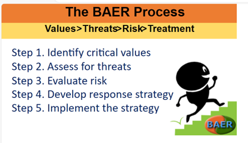
BAER Team Assembles 09 27 2024
Related Incident:
Publication Type: News
FOREST SERVICE BAER TEAM BEGINS WAPITI FIRE POST-FIRE ASSESSMENT
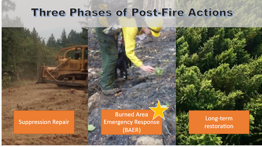
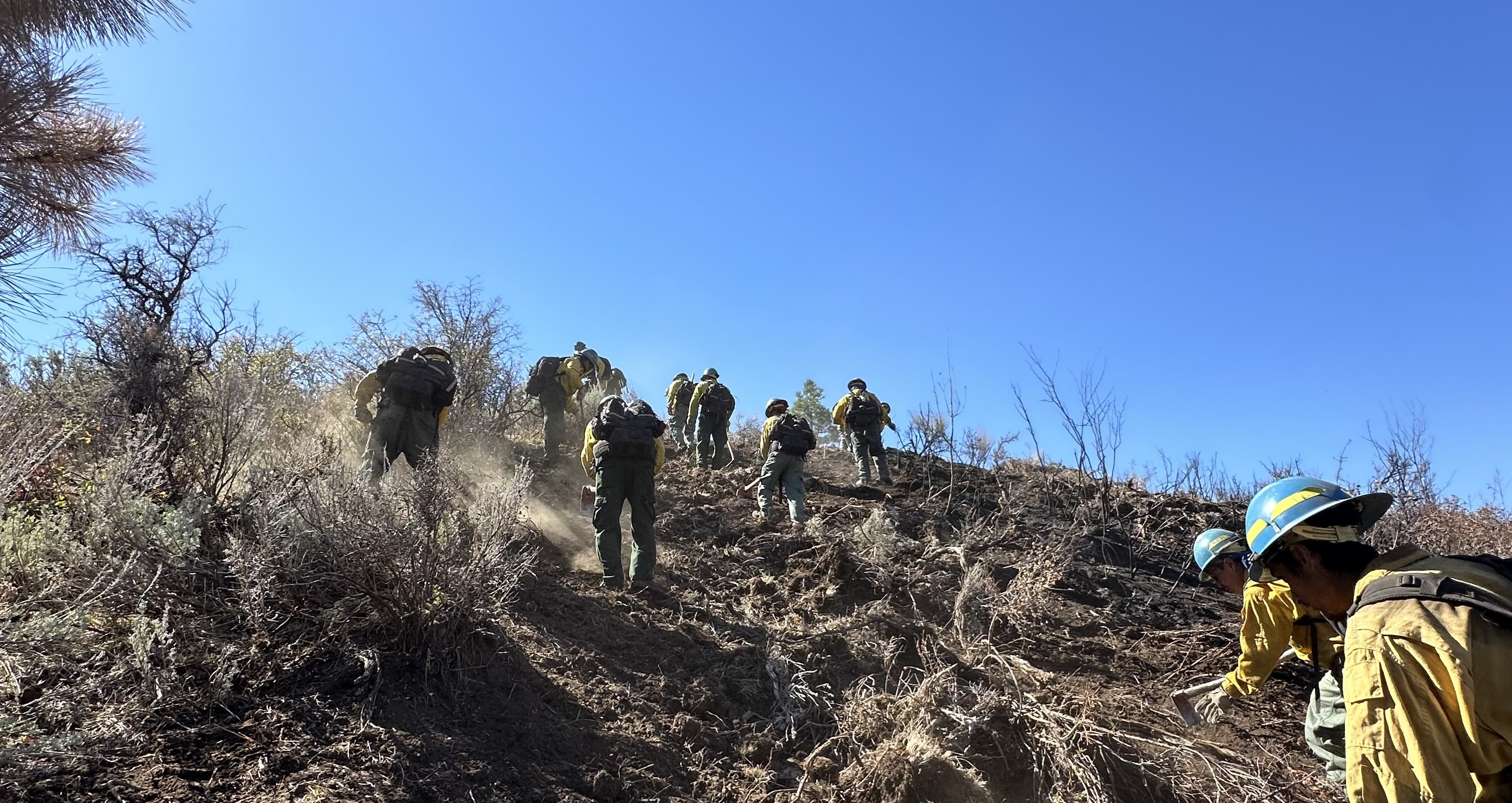
A Burned Area Emergency Response (BAER) team was recently established by the Sawtooth, Boise, and Salmon-Challis National Forests to begin its emergency survey of the burned area in the Wapiti Fire. BAER team surveys are rapid assessments that evaluate the burned watersheds and determine the potential for increased post-fire flooding, sediment flows, and rockslides.
BAER teams coordinate with the Natural Resources Conservation Service (NRCS), National Weather Service (NWS), U.S. Geological Survey (USGS), and other federal, state, counties, and local agencies as they assess potential post-fire impacts to the burned watersheds. Emergency stabilization BAER surveys are rapid assessments to identify imminent post-wildfire threats to human life and safety, property, and critical natural or cultural resources on National Forest System lands. The BAER team evaluates the burned area to identify watersheds with an increased potential for post-fire flooding, sediment delivery, and rockslides, and assists land managers in preparing for seasonal thunder cell storms or winter rainstorms. They also model hydrologic response throughout the burned area and share the team’s findings with the affected downstream agencies.
BAER teams may consist of scientists and specialists including hydrologists, geologists, soil scientists, road engineers, botanists, biologists, archeologists, and geographic information specialists. BAER teams collect field data during their burned area surveys to analyze through GIS and computer models and present their findings along with recommended BAER emergency stabilization treatments in a BAER assessment report. BAER reports are also shared with interagency cooperators who work with downstream private home and landowners to prepare for potential post-fire flooding and sediment flow impacts.
The Wapiti Fire BAER assessment team anticipates that it will take approximately two weeks to complete their burn area assessment report that will be reviewed by the Forest Supervisors and approved by the Regional Forester for the Intermountain Region.
The Forest Service will use this site to disseminate information pertaining to the BAER process for the Wapiti Fire. Shawn Robnett (shawn.robnett@usda.gov) is the BAER team lead representing the Boise, Sawtooth, and Salmon-Challis National Forests.
Expected Timeline:
- Team kickoff: September 26
- Final report submitted: October 7
Homes or businesses that could be impacted by flooding from federal land that result from wildfires may be eligible for flood insurance coverage from the National Flood Insurance Program (NFIP). Information about NFIP is available through FEMA at www.fema.gov/national-flood-insurance-program, or www.floodsmart.gov/wildfires. Other flood preparedness information is available at www.ready.gov/floods and www.floodsmart.gov/.
FOREST SERVICE Park PostFire BAER Assessment Report Summary Released 09 27 2024
Related Incident: Park Post-Fire BAER
Publication Type: News
FOREST SERVICE: Park Post-Fire BAER Assessment Report Summary Released
The Forest Service—Lassen National Forest completed a Burned Area Emergency Response (BAER) post-fire assessment of the Park burned area and affected watersheds to determine their response, soil conditions, potential threats, and recommended BAER emergency stabilization measures and actions on National Forest System (NFS) lands. BAER emergency treatments and activities are designed to decrease possible impacts to critical values from the burned areas during rainstorm events such as: human life and safety, property, critical natural resources, and cultural resources.
NOTE: Attached below as “Related Information” is a PDF documents called “Park Post-Fire BAER Assessment Report Summary_PUBLIC”.
BAER SAFETY MESSAGE: Everyone near and downstream from the burned areas should remain alert and stay updated on weather conditions that may result in heavy rains and increased water runoff. Flash flooding may occur quickly during heavy rain events--be prepared to act. Current weather and emergency notifications can be found at the National Weather Service website: www.weather.gov/sto/.