
Incident Publication
West Fire Daily Update Spanish 09 25 2024
Related Incident: 2024 - West Fire - TNF
Publication Type: News
Actualización de Información sobre Incendios
del Servicio Forestal
Contacto: Heather McLean
928-291-7354 (7am- 7pm)
2024.west@firenet.gov
ACTUALIZACIÓN: West Fire, Distrito de Payson
Septiembre 25, 2024
Tamaño: 15,053 acres Fecha de inicio: Agosto 28, 2024
Causa: Lightning Ubicación: Distrito de Payson, Arizona
Contención: 51% Combustibles:Pino ponderosa, coníferas mixtas, chaparral
Personal total: 165
Operaciones: Un equipo local de Tipo 3 asumió el mando del incendio ayer por la tarde y continuará asegurando la línea de fuego y reparando las líneas de bulldozer y manuales. Ayer, combustibles no quemados fueron encendidos por ignición aérea dentro del perímetro del incendio, contribuyendo al humo y cenizas en las comunidades vecinas. Las cuadrillas también están retirando equipos y suministros de incendio que ya no se necesitan. Excavadoras están trabajando a lo largo del borde este del incendio cerca de la carretera 646 para reparar daños, tenga precaución en esta área. El fuego y las llamas pueden ser visibles durante las horas nocturnas lejos de los bordes del incendio. El equipo de incendios está consciente del estado de evacuación de los residentes de Pine y Geronimo Estates, y está trabajando para reducirlo.
Clima: Hoy, soleado, cálido y seco con una temperatura máxima de 89 grados. 0% de probabilidad de precipitación con humedades en el rango del 20%. Vientos del este de 7 mph.
Seguridad: La salud y seguridad de los bomberos y del público siempre son la primera prioridad. Se pide al público que evite el área del incendio y tenga precaución alrededor del equipo de incendios en las carreteras.
Humo: El humo del Incendio West puede ser visible en las áreas circundantes durante muchos días. El humo se mantendrá en las áreas bajas por la mañana y se elevará a medida que aumenten las temperaturas durante el día y más tarde en la semana. Se recomienda a las personas sensibles al humo y a las personas con problemas respiratorios o enfermedades cardíacas que tomen medidas de precaución. Obtenga más información sobre los impactos del humo en el sitio web del Departamento de Calidad Ambiental de Arizona.
Cierres: El Bosque Nacional Tonto ha emitido un cierre para las tierras que rodean el Incendio West. Esto incluye el inicio del sendero Pine. https://inciweb.wildfire.gov/incident-publications/aztnf-2024-west-fire-tnf/us-forest-service-closure-order-for-west-fire-09-04-2024
Evacuaciones: Los residentes de Pine en el lado este de la SR 87 y al este de North Pine Creek Canyon Road están en estado de PREPARACIÓN. Los residentes de Geronimo Estates cerca del Incendio West están en estado de PREPARACIÓN. Para obtener información sobre el mapa interactivo del estado de evacuación, visite este enlace. https://nifc.maps.arcgis.com/apps/instant/sidebar/index.html?appic+9bf2ca222ss74f8697bc670ae9c2531a
Para las últimas noticias e información sobre el Bosque Nacional Tonto, síganos en Facebook @TontoNationalForest, en ‘X’ (anteriormente Twitter) @TontoForest o en Instagram @tontonationalforest y en el sitio web del Bosque Nacional Tonto: https://www.fs.usda.gov/tonto.
West Fire Daily Update English 09 25 2024
Related Incident: 2024 - West Fire - TNF
Publication Type: News
UPDATE: West Fire, Payson Ranger District
September25, 2024
Size: 15,053 acres Start Date: August 28, 2024
Cause: Lightning Location: Payson Ranger District, Arizona
Containment: 51% Fuels: Ponderosa pine, mixed conifer, chaparral
Total personnel: 165
Operations: A local Type 3 Team assumed command of the fire yesterday afternoon and will continue to secure fireline and repair dozer and hand line. Yesterday, unburned fuels were ignited by aerial ignition inside the perimeter of the fire, contributing to smoke and ash in neighboring communities. Crews are also backhauling equipment and fire supplies longer needed. Excavators are working along the east edge of the fire near 646 Road to repair damage, use caution in this area. Fire and flames may be visible during nighttime hours away from the edges of the fire. The fire team is mindful of the evacuation status of Pine and Geronimo Estates residents, and is working to lower it.
Weather: Today, sunny, warm and dry with a high temperature of 89 degrees. 0% chance of precipitation with humidities in the 20% range. East winds of 7 mph.
Safety: The health and safety of firefighters and the public are always the first priority. Members of the public are asked to avoid the fire area and use caution around fire equipment on the roads
Smoke: Smoke from the West Fire may be visible in the surrounding areas for many days. Smoke will linger in lower areas in the morning and rise as temperatures increase during the day and later in the week. Smoke-sensitive individuals and people with respiratory problems or heart disease are encouraged to take precautionary measures. Learn more about smoke impacts on the Arizona Department of Environmental Quality website.
Closures: The Tonto National Forest has issued a closure for land surrounding the West Fire. This includes the Pine Trailhead. https://inciweb.wildfire.gov/incident-publications/aztnf-2024-west-fire-tnf/us-forest-service-closure-order-for-west-fire-09-04-2024
Evacuations: Pine residents on the east side of SR 87 and east of North Pine Creek Canyon Road are in SET status. Geronimo Estates residents near the West Fire are in SET status. For information on the interactive map of evacuation status, visit https://nifc.maps.arcgis.com/apps/instant/sidebar/index.html?appic+9bf2ca222ss74f8697bc670ae9c2531a
For the latest news and information about the Tonto National Forest, follow along on Facebook @TontoNationalForest, ‘X’ (formerly Twitter) @TontoForest or Instagram @tontonationalforest and on the Tonto National Forest website: https://www.fs.usda.gov/tonto
Red Fire Daily Update for Wednesday 09 25 2024
Related Incident: Red Fire
Publication Type: News
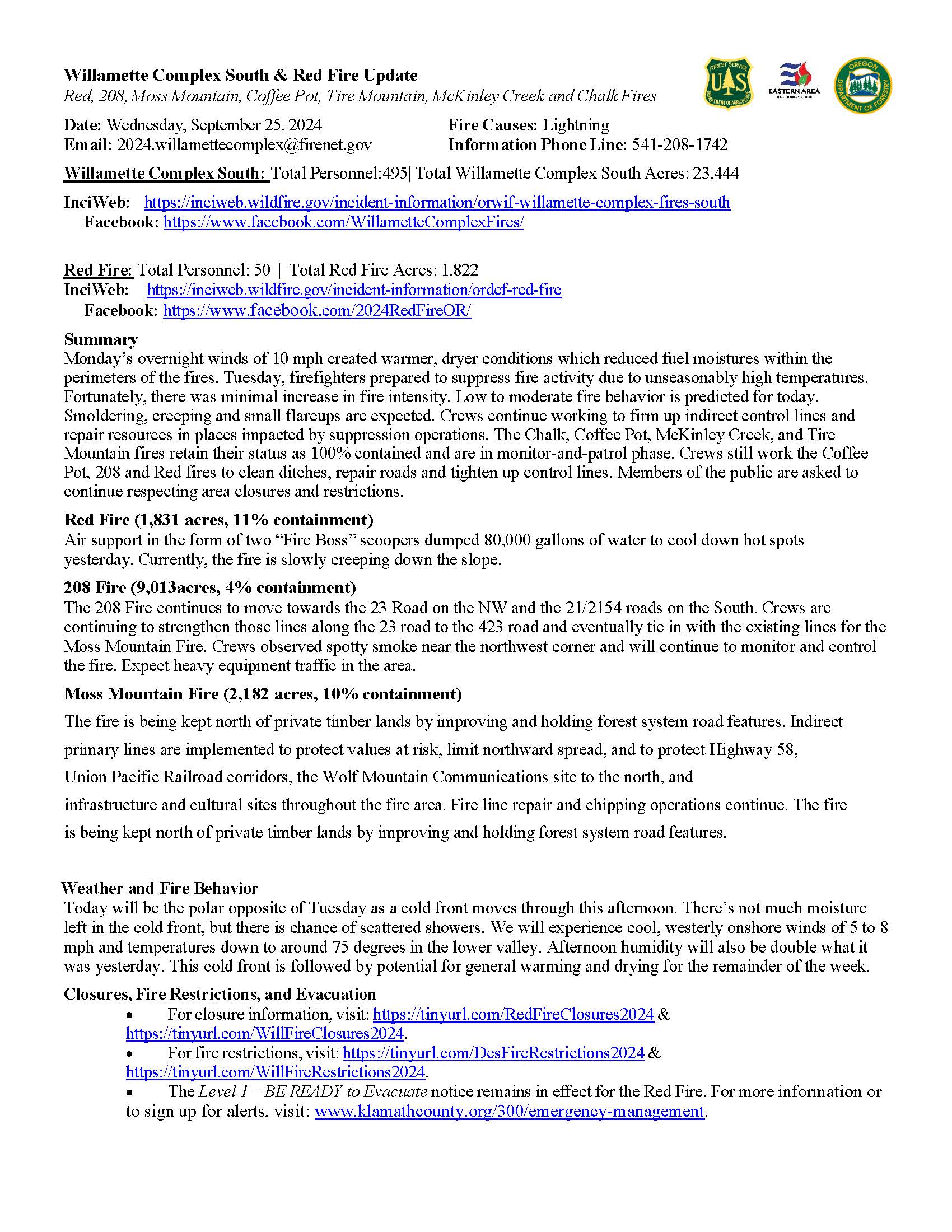
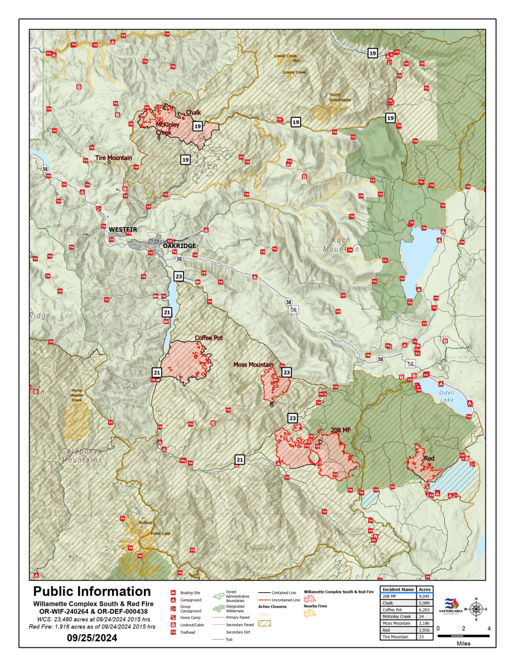
Willamette Complex South & Red Fire Update
Red, 208, Moss Mountain, Coffee Pot, Tire Mountain, McKinley Creek and Chalk Fires
Date: Wednesday, September 25, 2024
Fire Causes: Lightning
Email: 2024.willamettecomplex@firenet.gov
Information Phone Line: 541-208-1742
Willamette Complex South: Total Personnel:495| Total Willamette Complex South Acres: 23,444
InciWeb: https://inciweb.wildfire.gov/incident-information/orwif-willamette-complex-fires-south
Facebook: https://www.facebook.com/WillametteComplexFires/
Red Fire: Total Personnel: 50 | Total Red Fire Acres: 1,831
InciWeb: https://inciweb.wildfire.gov/incident-information/ordef-red-fire
Facebook: https://www.facebook.com/2024RedFireOR/
Summary
Monday’s overnight winds of 10 mph created warmer, dryer conditions which reduced fuel moistures within the perimeters of the fires. Tuesday, firefighters prepared to suppress fire activity due to unseasonably high temperatures. Fortunately, there was minimal increase in fire intensity. Low to moderate fire behavior is predicted for today. Smoldering, creeping and small flareups are expected. Crews continue working to firm up indirect control lines and repair resources in places impacted by suppression operations. The Chalk, Coffee Pot, McKinley Creek, and Tire Mountain fires retain their status as 100% contained and are in monitor-and-patrol phase. Crews still work the Coffee Pot, 208 and Red fires to clean ditches, repair roads and tighten up control lines. Members of the public are asked to continue respecting area closures and restrictions.
Red Fire (1,831 acres, 11% containment)
Air support in the form of two “Fire Boss” scoopers dumped 80,000 gallons of water to cool down hot spots yesterday. Currently, the fire is slowly creeping down the slope.
208 Fire (9,013acres, 4% containment)
The 208 Fire continues to move towards the 23 Road on the NW and the 21/2154 roads on the South. Crews are continuing to strengthen those lines along the 23 road to the 423 road and eventually tie in with the existing lines for the Moss Mountain Fire. Crews observed spotty smoke near the northwest corner and will continue to monitor and control the fire. Expect heavy equipment traffic in the area.
Moss Mountain Fire (2,182 acres, 10% containment)
The fire is being kept north of private timber lands by improving and holding forest system road features. Indirect primary lines are implemented to protect values at risk, limit northward spread, and to protect Highway 58, Union Pacific Railroad corridors, the Wolf Mountain Communications site to the north, and infrastructure and cultural sites throughout the fire area. Fire line repair and chipping operations continue. The fire is being kept north of private timber lands by improving and holding forest system road features.
Weather and Fire Behavior
Today will be the polar opposite of Tuesday as a cold front moves through this afternoon. There’s not much moisture left in the cold front, but there is chance of scattered showers. We will experience cool, westerly onshore winds of 5 to 8 mph and temperatures down to around 75 degrees in the lower valley. Afternoon humidity will also be double what it was yesterday. This cold front is followed by potential for general warming and drying for the remainder of the week.
Closures, Fire Restrictions, and Evacuation
- For closure information, visit: https://tinyurl.com/RedFireClosures2024 & https://tinyurl.com/WillFireClosures2024.
- For fire restrictions, visit: https://tinyurl.com/DesFireRestrictions2024 & https://tinyurl.com/WillFireRestrictions2024.
- The Level 1 – BE READY to Evacuate notice remains in effect for the Red Fire. For more information or to sign up for alerts, visit: www.klamathcounty.org/300/emergency-management.
Willamette Complex South Daily Update for Wednesday 09 25 2024
Related Incident: Willamette Complex Fires - South
Publication Type: News
Willamette Complex South & Red Fire Update
Red, 208, Moss Mountain, Coffee Pot, Tire Mountain, McKinley Creek and Chalk Fires
Date: Wednesday, September 25, 2024
Fire Causes: Lightning
Email: 2024.willamettecomplex@firenet.gov
Information Phone Line: 541-208-1742
Willamette Complex South: Total Personnel:495| Total Willamette Complex South Acres: 23,444
InciWeb: https://inciweb.wildfire.gov/incident-information/orwif-willamette-complex-fires-south
Facebook: https://www.facebook.com/WillametteComplexFires/
Red Fire: Total Personnel: 50 | Total Red Fire Acres: 1,831
InciWeb: https://inciweb.wildfire.gov/incident-information/ordef-red-fire
Facebook: https://www.facebook.com/2024RedFireOR/
Summary
Monday’s overnight winds of 10 mph created warmer, dryer conditions which reduced fuel moistures within the perimeters of the fires. Tuesday, firefighters prepared to suppress fire activity due to unseasonably high temperatures. Fortunately, there was minimal increase in fire intensity. Low to moderate fire behavior is predicted for today. Smoldering, creeping and small flareups are expected. Crews continue working to firm up indirect control lines and repair resources in places impacted by suppression operations. The Chalk, Coffee Pot, McKinley Creek, and Tire Mountain fires retain their status as 100% contained and are in monitor-and-patrol phase. Crews still work the Coffee Pot, 208 and Red fires to clean ditches, repair roads and tighten up control lines. Members of the public are asked to continue respecting area closures and restrictions.
Red Fire (1,831 acres, 11% containment)
Air support in the form of two “Fire Boss” scoopers dumped 80,000 gallons of water to cool down hot spots yesterday. Currently, the fire is slowly creeping down the slope.
208 Fire (9,013acres, 4% containment)
The 208 Fire continues to move towards the 23 Road on the NW and the 21/2154 roads on the South. Crews are continuing to strengthen those lines along the 23 road to the 423 road and eventually tie in with the existing lines for the Moss Mountain Fire. Crews observed spotty smoke near the northwest corner and will continue to monitor and control the fire. Expect heavy equipment traffic in the area.
Moss Mountain Fire (2,182 acres, 10% containment)
The fire is being kept north of private timber lands by improving and holding forest system road features. Indirect primary lines are implemented to protect values at risk, limit northward spread, and to protect Highway 58, Union Pacific Railroad corridors, the Wolf Mountain Communications site to the north, and infrastructure and cultural sites throughout the fire area. Fire line repair and chipping operations continue. The fire is being kept north of private timber lands by improving and holding forest system road features.
Weather and Fire Behavior
Today will be the polar opposite of Tuesday as a cold front moves through this afternoon. There’s not much moisture left in the cold front, but there is chance of scattered showers. We will experience cool, westerly onshore winds of 5 to 8 mph and temperatures down to around 75 degrees in the lower valley. Afternoon humidity will also be double what it was yesterday. This cold front is followed by potential for general warming and drying for the remainder of the week.
Closures, Fire Restrictions, and Evacuation
- For closure information, visit: https://tinyurl.com/RedFireClosures2024 & https://tinyurl.com/WillFireClosures2024.
- For fire restrictions, visit: https://tinyurl.com/DesFireRestrictions2024 & https://tinyurl.com/WillFireRestrictions2024.
- The Level 1 – BE READY to Evacuate notice remains in effect for the Red Fire. For more information or to sign up for alerts, visit: www.klamathcounty.org/300/emergency-management.
Rail Ridge and Wiley Flat Fire Daily Update 09 25 2024
Related Incident:
Publication Type: News
Rail Ridge and Wiley Flat Fire Daily Update
9-25-24
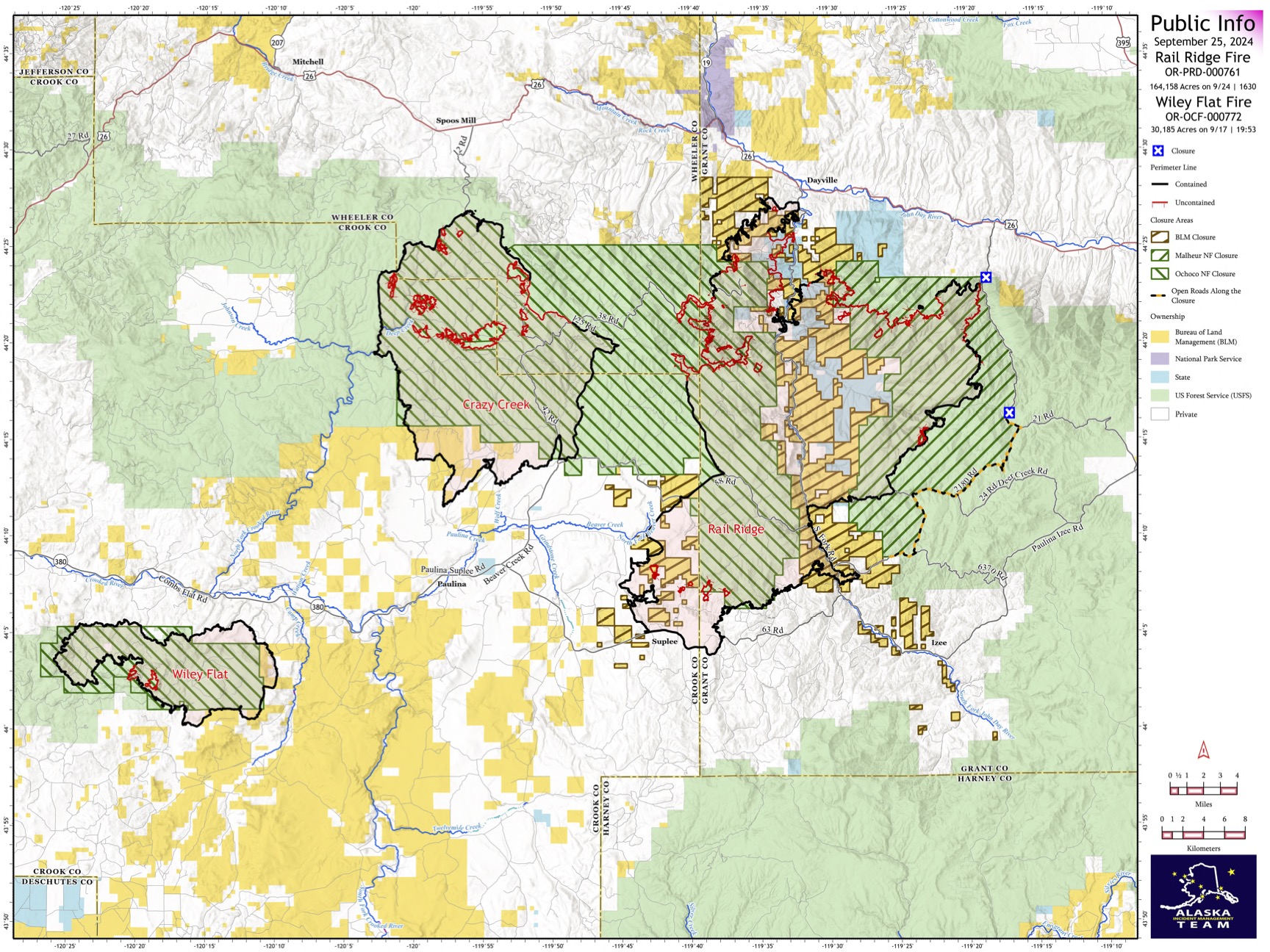
Rail Ridge Fire
Acres: 164,158 – Containment: 61% – Detection Date: Sept 2, 2024 – Cause: Lightning – Total resources: 1255
Operational Update: An increase in fire activity along the western edge of the Rail Ridge Fire produced a large smoke column yesterday afternoon. Shifting winds moved the fire northward toward a control line created with tactical burning operations over the last few shifts. These lines held the fire in check along Coffee Pot Ridge where hotshot crews and aerial resources were engaged to catch any spot fires. Another shift in wind is expected today, with gusts up to 40 MPH, along with high temperatures and low relative humidities. Active fire behavior is expected again this afternoon, and crews will continue to strengthen and reinforce containment lines along the western edge in the Black Canyon Wilderness and along the northern edge near Aldrich Mountain. Mop up and suppression repair efforts are underway around the perimeter of the fire where containment has been established.
The BLM, U.S. Forest Service and Oregon Department of Forestry are working in coordination to prioritize and complete suppression repair on federal, state and private lands. Landowners can submit a request for suppression repair assistance here: https://tinyurl.com/RailRidgeRepair
Wiley Flat Fire
Acres: 30,186 – Containment: 94% – Detection Date: Sept 2, 2024 – Cause: Lightning – Total resources: 63
Operational Update: Mop up and suppression repair is ongoing as crews work to eliminate any remaining heat signatures inside the fire perimeter.
Weather: Elevated temperatures and lower relative humidities with gusting winds up to 40 MPH are expected today. Fire activity is expected to increase midafternoon and will produce a visible smoke column.
Evacuations
Rail Ridge Evacuations: Level 1 and 2 evacuation zones for the Rail Ridge Fire remain in Grant County.
Wiley Flat Evacuations: Level 2 and 3 evacuation zones are in place for the Wiley Flat Fire in Crook County.
For Current Evacuation Levels in Wheeler, Crook and Grant counties, please visit: https://linktr.ee/RailRidgeFire
Closures
The U.S. Forest Service and Bureau of Land Management have implemented closures for the Rail Ridge and Wiley Flat Fires. For more details and closure maps, visit https://linktr.ee/RailRidgeFire
#RailRidgeFire2024 #WileyFlatFire2024 #FireYear2024

Buck Creek Fire Update 09 25 2024
Related Incident: Buck Creek Fire
Publication Type: News
(Silver Lake, Ore.) – The Buck Creek Fire started in heavy timber within the Yamsay Mountain Semi-Primitive Area on the Fremont-Winema National Forest, about 13 miles southwest of Silver Lake, Ore. The fire spread north and east into managed timber stands on National Forest lands with brush/grass understory and remains about 11 miles from the community of Silver Lake. In anticipation of assuming command of the fire later this week, the Incident Commander of the incoming fire management team was given a helicopter tour to gather information on conditions around the fire. Despite the heavy smoke produced by burning woody material, surveys around the fire detected no hot spots or burning debris within 100 feet of its perimeter.
Yesterday, all burning that took place on the fire occurred well within containment lines. Grading of all roads around the fire was completed. Road graders and water tenders were released from the incident to be available elsewhere. An Albach chipper, one of the most powerful all-road, self-propelled chippers, was engaged on the north side of the fire, processing large woody debris and returning chips to the forest floor. Chipping operations continued along roads used as secondary lines north, northwest, and northeast of the fire. Additional work included suppression repair on non-critical dozer lines, which are being restored to pre-fire conditions.
Today, with warmer temperatures and stronger southwesterly winds expected, efforts are focused on patrolling the eastern edge of the fire to ensure containment lines remain secure. Equipment operators will be completing suppression repair (pulling in berms and installing water bars) on dozer lines not serving as containment lines and chipping along roads used as secondary fire line. Backhauling of equipment continues and to date, nearly 30 miles of water hose has been returned to the Incident Command Post from the fire lines. Helicopters remain available to assist on-the-ground crews as needed.
Weather: Windy conditions are expected today with sustained southwest winds of 15 to 25 mph. Expect temperatures in the 70’s, with gradually decreasing winds once skies become cloudy this afternoon.
Safety: Firefighting equipment and personnel are present on local roads. For the safety of firefighters and the public, fire managers ask the public to drive carefully and remain clear of the fire areas. The public also plays an important role in preventing the next wildfire by using caution with all ignition sources. For fire prevention tips, visit: https://keeporegongreen.org.
Closures and Restrictions: Fire danger remains high. Campfire and other restrictions are in place within the Fremont-Winema National Forest. A forest closure order is in effect for the area around the Buck Creek Fire. For the complete order and map, as well as more detail on fire restrictions, go to: https://www.fs.usda.gov/fremont-winema. Christmas Valley Airport is being used as the helibase for fire operations and is temporarily closed to general aviation. A temporary flight restriction is in place over the Buck Creek Fire.
Smoke: Smoke from fires around the region may affect air quality. For more information on conditions and strategies on limiting exposure, go to: www.oregonsmoke.org or www.AirNow.gov.
Bachelor Complex Update 092524 09 25 2024
Related Incident: Bachelor Complex Fires
Publication Type: News
Bachelor Complex Fire Update
September 25, 2024
Quick Facts: Bachelor Complex
Size: 11,742 acres Start Date: September 8, 2024 Location: 20 miles SW Bend, OR
Personnel: 140 Containment: 50%
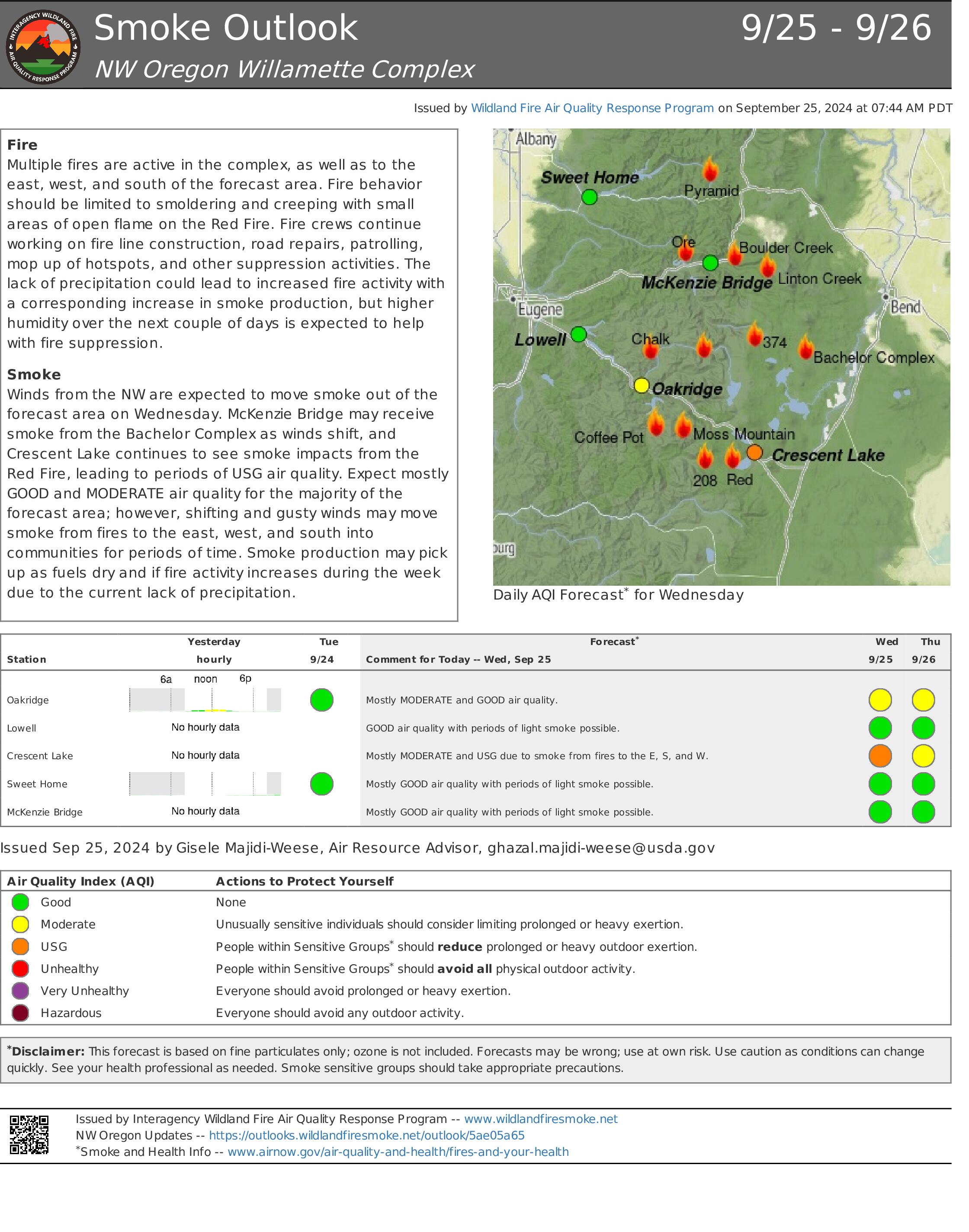
Today, a cold front will move through the Pacific Northwest, allowing for strong and gusty southwest winds, leading to near critical fire weather in the area. This may lead to an increase in fire activity and increased smoke coming from the Bachelor Complex fires. There is about a 15% chance for wetting rain with the band of moisture moving in with the front, and a few hundredths of an inch will be possible. Thunderstorms are possible in the surrounding areas.
Bachelor Complex:
Yesterday, in the southeastern area of the fire the chipping operation was completed. On the northeast flank, firefighters finished line construction near the Edison Trail and will continue to mop-up and patrol in the area. Firefighters continued work within the interior of the fire, taking down hazard trees along Forest Service Road 4525 and suppressing isolated pockets of heat with the help of helicopter bucket drops. On the uncontained northern edge of the Little Lava Fire near the base of Sheridan Mountain, the fire continued to back up against the slope and isolated small group torching was observed.
Today’s weather and the potential for outflow winds from nearby thunderstorms increases the potential for perimeter growth in areas currently not contained. In the area of Forest Service Road 45 and on the southern edge of the fire, patrol and mop-up efforts are ongoing as crews address any areas of heat found near the line. Suppression repair efforts continue today on the fire and preparation work on line construction on the westside of the fire. Forest Service Road 45 continues to be closed due to firefighting efforts in the area and safety concerns from fire weakened trees near the roadway.
Weather and Fire Behavior: A cold front will move through the Pacific Northwest today, allowing for possible strong and gusty southwest winds, and slight chances for light precipitation. Winds will be out of the southwest for much of the day, around 12-15 mph sustained with gusts up to 25-30 mph. Cloud cover is expected over the fire area in the late afternoon and evening. Behind the passage of the frontal boundary on Thursday, mild and dry conditions will prevail with locally breezy westerly winds.
Closures: While evacuations have been lifted, there is still a temporary emergency fire closure in place on the Deschutes National Forest for the Bachelor Complex. To view the closure order and map, visit: https://www.fs.usda.gov/alerts/deschutes/alerts-notices.
InciWeb: https://inciweb.wildfire.gov/incident-information/ordef-bachelor-complex-fires
YouTube: https://www.youtube.com/@CentralOregonFireInfo?app=desktop
Fire Information Line: (541) 249-9829, 8:00 a.m. to 8:00 p.m.
Smoke & Air Quality Information: fire.airnow.gov
Emergency Closure Order BLM Roseburg District 09 25 2024
Related Incident:
Publication Type: Closures
AMENDED EMERGENCY CLOSURE ORDER
Bureau of Land Management
Roseburg District, Swiftwater Resource Area
On July 26, 2024, the Roseburg District issued an Emergency Closure Order that closed Bureau of Land Management (BLM) lands within T.24 S., R.01 W. sections 1, 2, 11, 12, 13, 14, 23, 24, 25, 26, and 35. As well as T.25 S., R.01 W. sections 1, 11, 14, 23, 24, and 25. This Amended Emergency Closure Order updates the BLM lands that will remain closed until such time as conditions allow for safe use of the public lands.
Action: As the Swiftwater Field Manager I have determined that fire and resource conditions have changed, and the current area closure is no longer needed. However Pursuant to 43 CFR 9212.2, the BLM hereby provides notice that the BLM administered-public lands described below remain closed to all forms of public access until the No Man Fire is declared controlled and/or conditions change to allow for an amendment to the closure area. Continuation of this closure is necessary to provide for public safety, reduce conflicts with emergency crews, and allow for fire suppression and burned area site recovery. BLM will post closure signs at main entry points to this area.
Affected Area: BLM road(s) 24-1-25 and 24-1-25.1 from the junction with BLM road 24-1-26 (Francis Creek) East to the Roseburg District Boundary in Township 24 South Range 1 West Section 25 will remain as closed. This order rescinds the closure of all other BLM lands described in the July 26, 2024, closure order. (Please see attached map).
Prohibitions: The public must not enter the closure area. All uses within the closure area are prohibited. You must not enter by any means of motorized or non-motorized transportation, to include foot traffic.
Exemptions: Pursuant to Title 43 CFR 9212.3, the following persons are exempt from the provisions of this Order:
1. Any Federal, State, or Local Officer, or member of an organized medical, rescue or firefighting force engaged in fire, emergency, or law enforcement activities, or public utility employees engaged in emergency repairs.
2. BLM employees, contractors, agents or other individuals engaged in official duties.
3. Individuals operating within the scope of their official and legitimate governmental duties.
4. Parties who carry written approval signed by the BLM Authorized Officer allowing access to the described public lands. Exemption requests must be submitted to the Roseburg District Office 777 NW Garden Valley Blvd, Roseburg, OR 97471, telephone (541) 440-4930
Penalties: (43 CFR 9212.4) Any person who knowingly and willingly Violates the regulations of this title shall, upon conviction, be subject to a fine not more than $1,000 or to imprisonment of not than 12 months, or both.
Effective: This amended closure is effective at 12:01 p.m. on September 25, 2024, and will remain in effect until such time as conditions allow for safe use of the affected public lands.
Signed By:
_______________________________________ _9/25/24___
Michael J Korn, Swiftwater Field Manager
Fossil Complex Daily Update 9252024 09 25 2024
Related Incident: Fossil Complex
Publication Type: News
Fossil Complex at 100% Containment
FOSSIL, Ore. – The Fossil Complex fires are now at 100% containment. This means there are no concerns of fire growth or escapement from the fires in the Fossil Complex. With this work being done, focus will now be fully on suppression repair.
Fossil Complex suppression repair is now focused on the Service Fire and Two Cabin Fire. The repair on the Canyon and Kinzua fires is complete. On the north side of the Service Fire, crews and equipment are removing dozer berms and installing water bars. On the south side of the Service Fire repair work areas expand to include the “interior unburned island” containment lines. Suppression repair is expected to be complete on the Canyon Fire today.
Suppression repair on the Lonerock Fire will be on the northwest perimeter working southward. The northeast side repair effort will work south towards Hwy 207.
On the Battle Mountain Complex, crews are working on the southeast side in the Pepper Creek, area mapping dozer line. In the Deer Creek area crews will complete repairs.
There will be a flight over the fire area today to verify mapping of dozer lines and areas impacted by the fire suppression efforts.
Today’s weather will be in the lower 80s before a cold front approaches bringing stormy conditions. The cold front brings a threat of rain with increased winds and a slight chance of thunderstorms.
Progress on suppression repair over the fire areas is a slow process over a wide area. There are 710 miles of fire line. So far crews have completed 329 miles of line (Fossil to Coos Bay is 330 miles).
Videos: Recordings of the Daily Operations Updates and other stories are available at: https://www.youtube.com/@FossilComplex.
Homestead Complex and Lane 1 Fire Daily Update 09 25 2024
Related Incident: Lane 1 Fire
Publication Type: News
Email: 2024.homesteadcomplex@firenet.gov
Fire Information Line: 541-208-7100 (Staffed 8 a.m. to 8 p.m.)
Facebook: https://t.ly/mSLvP
Inciweb: https://t.ly/syeHa
September 25, 2024
There are five fires under active management within the Lane 1 and Homestead Complex, totaling approximately 35,860 acres, with 630 people assigned. The Lane 1 fire is 99% contained, and the Homestead Complex is 35% contained.
Crews are clearing and repairing roads impacted by the fires and by fire suppression activities. 101 miles of roadside have been chipped with 27 miles remaining, and 70 miles of road have been repaired with 58 miles remaining. For the Lane 1 Fire, 80 miles of roadside have been chipped with 5 miles remaining, and 58 miles of road has been repaired with 35 miles remaining.
Firefighters are improving containment lines across the fire area by reducing fuels through mastication, chipping wood, and hauling fuels to landings away from the fire. There are still many miles of uncontained fire edge. Crews have been systematically searching fire perimeters and extinguishing all detected hot spots, with mop up and patrol as needed.
On the Horse Heaven Fire, infrared detected hot spots in the northwest portion of the fire. Firefighters extinguished and mopped up those areas. Crews are patrolling in the south. Chipping and grading continue on the 3839 Road to the east of the Horse Heaven Fire area. Firefighters used helicopter water drops to suppress hot spots in the north.
Smoke was seen on the Fuller Lake Fire today. Expect to see new areas of fire as fuels continue to dry out over the next few days. Fire will continue to back, creep, and smolder in the Boulder Creek Wilderness area. On the southeast portion of the Fuller Lake Fire, a new spot fire was discovered and extinguished. Fuel break work continues in the southeast portion with 4 masticators, 2 crews, and 2 chippers. Firefighters used two helicopters to drop water to support firefighters on the ground.
On the northern part of the Bullpup Fire, crews are chipping, roads are being repaired, and culverts are being cleaned out. Grading will begin on the 3850 Road which is a major access road for fire crews.
On the No Man Fire, no fire was detected. Crews will maintain a presence in the area for the next few days.
On the Lane 1 Fire, Chipping was completed on the east side of the Lane 1 Fire along Pudding Road, and the Umpqua Forest Road Crew will begin road rehabilitation work which is expected to take 8 days. Chipping has been completed on the 2241 Road and road grading will continue on the 2263 Road. The rest of Lane 1 is in patrol status.
Closures and fire restrictions: The Umpqua National Forest and the Bureau of Land Management (BLM) have issued revised closure orders. Two closure orders impact the Umpqua National Forest https://t.ly/Mvn6G. A Bureau of Land Management (BLM) Roseburg District closure order is in effect for BLM road 24-1-25.0, bordering the Umpqua National Forest closure north of Steamboat https://t.ly/uWX6l. A BLM Northwest Oregon District closure west of the Lane 1 fire has been lifted. https://t.ly/oW1lG.
Weather and fire behavior: Increasing clouds and cooler weather will keep temperatures in the 60s. There is a possibility of slight rain in the late afternoon to midnight. Thursday will see the start of a warming trend into the weekend heating things up again with fuels continuing to dry out. Expect an increase in fire behavior and smoke production with new fires possibly popping up.