
Incident Publication
Bachelor Complex Update September 24 2024 09 24 2024
Related Incident: Bachelor Complex Fires
Publication Type: News
Quick Facts: Bachelor Complex
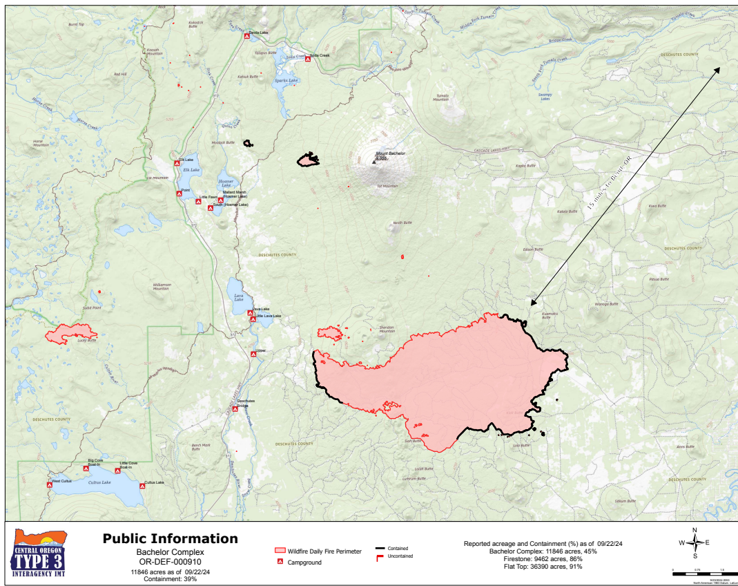
Size: 11,742 acres Start Date: September 8, 2024 Location: 20 miles SW Bend, OR
Personnel: 146 Containment: 39%
Today will be the warmest and driest day of the week as a strong high-pressure system sets up over the fire area. This will lead to an increase in fire activity and increased smoke coming from the Bachelor Complex fires. Firefighters continue to mop-up and have aerial assets available to support their efforts if needed.
Bachelor Complex:
Yesterday, the hotter and drier conditions contributed to increased consumption of fuels within the fire perimeter. Along the uncontained area of the Little Lava Fire near the base of Sheridan Mountain, the weather and fuel conditions led to an increase in fire activity and smoke as the fire backed up against the slope. Today’s weather and the predicted shift in wind direction in the afternoon increases the potential for perimeter growth in the area. On the northeast flank, firefighters continued to prepare line near the Edison Trail and will continue those operations today. In the area of Forest Service Road 45 and on the southern edge of the fire, patrol and mop-up efforts are ongoing as crews address areas of heat found near the line. A small firing operation took place yesterday along the southern edge to help secure the line and limit the interior spread. Suppression repair efforts continue today on the westside of the fire. Forest Service Road 45 continues to be closed due to firefighting efforts in the area and safety concerns from fire weakened trees near the roadway.
On incident #846, which is in the Kwohl Butte area, firefighters completed their operations and hiked out at the end of shift yesterday. This incident will continue to be monitored by air.
Weather and Fire Behavior: There will be a strong high-pressure system setting up over the region which will bring warmer and drier conditions to the fire area. This high pressure will shift eastward as upper level troughing develops offshore. This pattern will lead to a period of elevated fire weather conditions through Wednesday. Today, high temperatures are expected in the upper 70s to mid 80s, with low relative humidity around 23% - 28%. Winds will be out of the south in the morning, shifting to the west in the late afternoon, around 6-10 mph with gusts 15-18 mph. A cold front will then move through on Wednesday, bringing strong and gusty southwest winds, 12-15 mph with gusts of 25-30 mph. This front has the potential to bring gusty and adverse winds to the fire area ahead of the weather system. This may lead to increased fire activity and short crown runs are possible.
Closures: While evacuations have been lifted, there is still a temporary emergency fire closure in place on the Deschutes National Forest for the Bachelor Complex. To view the closure order and map, visit: https://www.fs.usda.gov/alerts/deschutes/alerts-notices.
InciWeb: https://inciweb.wildfire.gov/incident-information/ordef-bachelor-complex-fires
YouTube: https://www.youtube.com/@CentralOregonFireInfo?app=desktop
Fire Information Line: (541) 249-9829, 8:00 a.m. to 8:00 p.m.
Smoke & Air Quality Information: fire.airnow.gov
BLM Southwest District to conduct prescribed fire treatment on Carpenter Ridge on Wednesday Sept 25 2024 09 24 2024
Related Incident:
Publication Type: Announcement
If conditions are favorable, this Wednesday, September 25, 2024, BLM Southwest District Fire Management plans to conduct prescribed fire treatments on Carpenter Ridge in the Uncompahgre Field Office. Project goals are to reduce hazardous fuels, improve habitat for big game species, and build a more resilient ponderosa pine stand.
The plan is to treat approximately 200 acres of ponderosa pine litter and oak brush in the project area, which is located at the west end of Paradox Valley about 5 miles north of Paradox in Montrose County, CO. While Southwest Fire hopes to complete the treatments in a single day, a change in conditions could extend the treatment window through the end of the week. No road closures are planned.
A smoke permit obtained from the Colorado State Air Pollution Control Division identifies atmospheric conditions under which the burn can be implemented. Smoke may be visible and can affect your health. For more information, visit https://www.colorado.gov/pacific/cdphe/wood-smoke-and-health.
For more information on prescribed fire treatments in the Southwest District, look for updates on BLM Colorado Fire Facebook or BLM Colorado Fire Twitter (X).
Red Fire Daily Update for Tuesday 09 24 2024
Related Incident: Red Fire
Publication Type: News
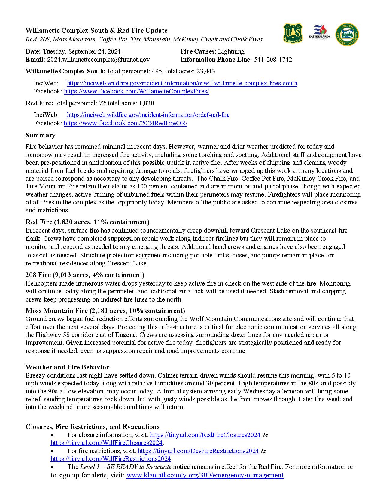
Willamette Complex South & Red Fire Update
Red, 208, Moss Mountain, Coffee Pot, Tire Mountain, McKinley Creek and Chalk Fires
Date: Tuesday, September 24, 2024
Fire Causes: Lightning
Email: 2024.willamettecomplex@firenet.gov
Information PhoneLine: 541-208-1742
Willamette Complex South: total personnel: 495; total acres: 23,443
InciWeb: https://inciweb.wildfire.gov/incident-information/orwif-willamette-complex-fires-south
Facebook: https://www.facebook.com/WillametteComplexFires/
Red Fire: total personnel: 72; total acres: 1,830
InciWeb: https://inciweb.wildfire.gov/incident-information/ordef-red-fire
Facebook: https://www.facebook.com/2024RedFireOR/
Summary
Fire behavior has remained minimal in recent days. However, warmer and drier weather predicted for today and tomorrow may result in increased fire activity, including some torching and spotting. Additional staff and equipment have been pre-positioned in anticipation of this possible uptick in active fire. After weeks of chipping and clearing woody material from fuel breaks and repairing damage to roads, firefighters have wrapped up this work at many locations and are poised to respond as necessary to any developing threats. The Chalk Fire, Coffee Pot Fire, McKinley Creek Fire, and Tire Mountain Fire retain their status as 100 percent contained and are in monitor-and-patrol phase, though with expected weather changes, active burning of unburned fuels within their perimeters may resume. Firefighters will place monitoring of all fires in the complex as the top priority today. Members of the public are asked to continue respecting area closures and restrictions.
Red Fire (1,830 acres, 11% containment)
In recent days, surface fire has continued to incrementally creep downhill toward Crescent Lake on the southeast fire flank. Crews have completed suppression repair work along indirect firelines but they will remain in place to monitor and respond as needed to any emerging threats. Additional hand crews and engines have also been engaged to assist as needed. Structure protection equipment including portable tanks, hoses, and pumps remain in place for recreational residences along Crescent Lake.
208 Fire (9,013 acres, 4% containment)
Helicopters made numerous water drops yesterday to keep active fire in check on the west side of the fire. Monitoring will continue today along the perimeter, and additional air attack will be used if needed. Slash removal and chipping crews keep progressing on indirect fire lines to the north.
Moss Mountain Fire (2,181 acres, 10% containment)
Ground crews began fuel reduction efforts surrounding the Wolf Mountain Communications site and will continue that effort over the next several days. Protecting this infrastructure is critical for electronic communication services all along the Highway 58 corridor east of Eugene. Crews are assessing surrounding dozer lines for any needed repair or improvement. Given increased potential for active fire today, firefighters are strategically positioned and ready for response if needed, even as suppression repair and road improvements continue.
Weather and Fire Behavior
Breezy conditions last night have settled down. Calmer terrain-driven winds should resume this morning, with 5 to 10 mph winds expected today along with relative humidities around 30 percent. High temperatures in the 80s, and possibly into the 90s at low elevation, may occur today. A frontal system arriving early Wednesday afternoon will bring some relief, sending temperatures back down, but with gusty winds possible as the front moves through. Later this week and into the weekend, more seasonable conditions will return.
Closures, Fire Restrictions, and Evacuations
- For closure information, visit: https://tinyurl.com/RedFireClosures2024 & https://tinyurl.com/WillFireClosures2024.
- For fire restrictions, visit: https://tinyurl.com/DesFireRestrictions2024 & https://tinyurl.com/WillFireRestrictions2024.
- The Level 1 – BE READY to Evacuate notice remains in effect for the Red Fire. For more information or to sign up for alerts, visit: www.klamathcounty.org/300/emergency-management.
Willamette Complex South Daily Update for Tuesday 09 24 2024
Related Incident: Willamette Complex Fires - South
Publication Type: News
Willamette Complex South & Red Fire Update
Red, 208, Moss Mountain, Coffee Pot, Tire Mountain, McKinley Creek and Chalk Fires
Date: Tuesday, September 24, 2024
Fire Causes: Lightning
Email: 2024.willamettecomplex@firenet.gov
Information PhoneLine: 541-208-1742
Willamette Complex South: total personnel: 495; total acres: 23,443
InciWeb: https://inciweb.wildfire.gov/incident-information/orwif-willamette-complex-fires-south
Facebook: https://www.facebook.com/WillametteComplexFires/
Red Fire: total personnel: 72; total acres: 1,830
InciWeb: https://inciweb.wildfire.gov/incident-information/ordef-red-fire
Facebook: https://www.facebook.com/2024RedFireOR/
Summary
Fire behavior has remained minimal in recent days. However, warmer and drier weather predicted for today and tomorrow may result in increased fire activity, including some torching and spotting. Additional staff and equipment have been pre-positioned in anticipation of this possible uptick in active fire. After weeks of chipping and clearing woody material from fuel breaks and repairing damage to roads, firefighters have wrapped up this work at many locations and are poised to respond as necessary to any developing threats. The Chalk Fire, Coffee Pot Fire, McKinley Creek Fire, and Tire Mountain Fire retain their status as 100 percent contained and are in monitor-and-patrol phase, though with expected weather changes, active burning of unburned fuels within their perimeters may resume. Firefighters will place monitoring of all fires in the complex as the top priority today. Members of the public are asked to continue respecting area closures and restrictions.
Red Fire (1,830 acres, 11% containment)
In recent days, surface fire has continued to incrementally creep downhill toward Crescent Lake on the southeast fire flank. Crews have completed suppression repair work along indirect firelines but they will remain in place to monitor and respond as needed to any emerging threats. Additional hand crews and engines have also been engaged to assist as needed. Structure protection equipment including portable tanks, hoses, and pumps remain in place for recreational residences along Crescent Lake.
208 Fire (9,013 acres, 4% containment)
Helicopters made numerous water drops yesterday to keep active fire in check on the west side of the fire. Monitoring will continue today along the perimeter, and additional air attack will be used if needed. Slash removal and chipping crews keep progressing on indirect fire lines to the north.
Moss Mountain Fire (2,181 acres, 10% containment)
Ground crews began fuel reduction efforts surrounding the Wolf Mountain Communications site and will continue that effort over the next several days. Protecting this infrastructure is critical for electronic communication services all along the Highway 58 corridor east of Eugene. Crews are assessing surrounding dozer lines for any needed repair or improvement. Given increased potential for active fire today, firefighters are strategically positioned and ready for response if needed, even as suppression repair and road improvements continue.
Weather and Fire Behavior
Breezy conditions last night have settled down. Calmer terrain-driven winds should resume this morning, with 5 to 10 mph winds expected today along with relative humidities around 30 percent. High temperatures in the 80s, and possibly into the 90s at low elevation, may occur today. A frontal system arriving early Wednesday afternoon will bring some relief, sending temperatures back down, but with gusty winds possible as the front moves through. Later this week and into the weekend, more seasonable conditions will return.
Closures, Fire Restrictions, and Evacuations
- For closure information, visit: https://tinyurl.com/RedFireClosures2024 & https://tinyurl.com/WillFireClosures2024.
- For fire restrictions, visit: https://tinyurl.com/DesFireRestrictions2024 & https://tinyurl.com/WillFireRestrictions2024.
- The Level 1 – BE READY to Evacuate notice remains in effect for the Red Fire. For more information or to sign up for alerts, visit: www.klamathcounty.org/300/emergency-management.
Buck Creek Fire Update 09 24 2024
Related Incident: Buck Creek Fire
Publication Type: News
(Silver Lake, Ore.) – The Buck Creek Fire started in heavy timber within the Yamsay Mountain Semi-Primitive Area on the Fremont-Winema National Forest, about 13 miles southwest of Silver Lake, Ore. The fire spread north and east into managed timber stands on National Forest lands with brush/grass understory and remains about 11 miles from the community of Silver Lake.
Yesterday, firefighters used aerial and hand-held infrared devices and gridding techniques to aid them in finding hot spots near the fire line. Around most of the fire, crews further secured containment by extinguishing hot spots several dozen feet inside containment lines. Chipping operations continued along roads used as secondary lines north, northwest, and northeast of the fire. Grading of Forest Road 2804 was completed and backhaul of water handling equipment continued.
Today, in preparation for tomorrow’s forecast windy conditions, crews are seeking out and extinguishing any remaining hotspots within several hundred feet of secured containment line, focusing on the eastern edge of the fire as southwest winds are expected. Additionally, most of the previous day’s activities will continue. Crews will patrol the fire perimeter to ensure the lines remain secure. Equipment operators will work on restoring roads, completing suppression repair (pulling in berms and installing water bars) on dozer lines not serving as containment lines and chipping along roads used as secondary fire line. Backhauling efforts are ongoing. Helicopters remain available to assist on-the-ground crews as needed.
Weather: Unseasonably warm weather is expected today with temperatures forecast 15 degrees above normal, rising to the mid to high 80s in the afternoon. Humidity will reach the low 20s.Wind direction will be from the south. Tomorrow, winds will increase to 15-20 mph, with gusts of 30-35 mph, ahead of an approaching cold front.
Safety: Firefighting equipment and personnel are present on local roads. For the safety of firefighters and the public, fire managers ask the public to drive carefully and remain clear of the fire areas. The public also plays an important role in preventing the next wildfire by using caution with all ignition sources. For fire prevention tips, visit: https://keeporegongreen.org.
Closures and Restrictions: Fire danger remains high. Campfire and other restrictions are in place within the Fremont-Winema National Forest. A forest closure order is in effect for the area around the Buck Creek Fire. For the complete order and map as well as more detail on fire restrictions, go to: https://www.fs.usda.gov/fremont-winema. Christmas Valley Airport is being used as the helibase for fire operations and is temporarily closed to general aviation. A temporary flight restriction is in place over the Buck Creek Fire.
Smoke: Smoke from fires around the region may affect air quality. For more information on conditions and strategies on limiting exposure, go to: www.oregonsmoke.org or www.AirNow.gov.
Homestead Complex and Lane 1 Fire Daily Update 09 24 2024
Related Incident: Lane 1 Fire
Publication Type: News
Email: 2024.homesteadcomplex@firenet.gov
Fire Information Line: 541-208-7100 (Staffed 8 a.m. to 8 p.m.)
Facebook: https://t.ly/mSLvP
Inciweb: https://t.ly/syeHa
September 24, 2024
There are five fires under active management within the Lane 1 and Homestead Complex, totaling approximately 35,803 acres, with 661 people assigned. The Lane 1 fire is 99% contained. The Homestead Complex of fires is 35% contained overall. The goal of this fire suppression and repair work is to protect the values at risk: communities and infrastructure; private timber lands; and public resources, including recreation opportunities and fish spawning habitat.
On the Homestead Complex, crews are clearing and repairing roads impacted by the fires and by fire suppression activities. 100 miles of roadside have been chipped with 28 miles remaining, and 68 miles of road have been repaired with 59 miles remaining. For the Lane 1 Fire, 77 miles of roadside have been chipped with 8 miles remaining, and 55 miles of road has been repaired with 38 miles remaining.
Crews are improving containment lines across the fire area by reducing fuels through mastication, chipping wood, and hauling fuels to landings away from the fire. There are still many miles of uncontained fire edge. Crews have been systematically searching fire perimeters and extinguishing all detected hot spots, with mop up and patrol as needed.
On the Horse Heaven Fire, there has been an increase in fire activity on the northwest portion of the fire. Crews are mopping up hot spots. Crews are making progress chipping roadside fuels, cleaning ditches and then grading the roads to strengthen and preserve the roads for the future use. Approximately 4 days of chipping and road grading remain on the Horse Heaven Fire.
On the Fuller Lake and Bullpup Fires, 4 masticators and 2 chippers are creating fuel breaks to contain the fire on the 3810 road on the east side of the Fuller Lake fire. Crews hope to complete this project in the next 7 or 8 days. Firefighters will continue to patrol for fire and mop up as needed. Crews used helicopter water drops to suppress emerging hot spots.
On the No Man Fire, firefighters have detected fire in the tops of trees near the fire line, requiring the trees to be felled. Crews will continue to patrol areas to search and quench any fires or hot spots.
On the Lane 1 Fire, crews are within a week of finishing up chipping roadside fuels. Road repair and grading is ongoing. Firefighters are patrolling to identify and suppress any emerging hot spots as the weather warms and dries. 91% of the chipping has been completed to date.
Closures and fire restrictions: Two closure orders impact the Umpqua National Forest https://t.ly/Mvn6G. The forest is in Moderate Fire Danger with no Public Use Restrictions https://t.ly/LI4cd. A Bureau of Land Management (BLM) Roseburg District closure order is in effect for portions of BLM land bordering the Umpqua National Forest closure north of Steamboat https://t.ly/uWX6l. A BLM Northwest Oregon District closure is also in place for an area west of the Lane 1 fire https://t.ly/oW1lG.
Weather and fire behavior: Expect a very warm and dry day, with temperatures in the 80–90-degree range. This weather is the warmest and driest in almost two weeks, leading to a predicted increase in fire behavior and smoke production. Wednesday will start a trend toward cooler weather.
Fossil Complex Daily Update 9242024 09 24 2024
Related Incident: Fossil Complex
Publication Type: News
Suppression Repair is the Main Focus for Crews
FOSSIL, Ore. – Suppression repair crews will continue work on all three fire areas - the Fossil Complex, the Lonerock Fire and the Battle Mountain Complex.
Fossil Complex suppression repair is mainly focused on the Service Fire. The north side work will continue working from the west to the east side repairing dozer berms and installing water bars. The current work area is in steep terrain, so a lot of the water bar work is being done by hand while equipment works elsewhere. The placement of water bars on containment lines, staging areas, and other disturbed areas mitigates erosion on the roads when the winter rains arrive.
Mop up on the Service Fire is in the final stages. There are areas on the north and southeast side where crews are doing final checks to make sure there is no chance of flare ups that could threaten containment lines. Smoke from the fire’s interior may be seen for quite some time in the coming weeks before the onset of seasonal wetting rains.
The focus of suppression repair on the Lonerock Fire will be on the north end where crews are working to repair areas back to normalcy.
On the Battle Mountain Complex, crews will be working on the southeast side in the Long Creek area where there was a significant amount of dozer line built during fire suppression efforts. They will be working from the west to the east repairing where needed and ensuring that all dozer lines are accurately mapped.
Today’s weather will be in the lower upper 80s and lower 90s. Winds will continue to be light out of the west and relative humidity in the lower 20s. Tomorrow a cold weather front will move through the area dropping temperatures and increasing winds.
Videos: Recordings of the Daily Operations Updates and other stories are available at: https://www.youtube.com/@FossilComplex.
Willamette Complex North Fire Update 09 24 2024
Related Incident: North Willamette Complex
Publication Type: News
Willamette Complex North Update
Boulder Creek, Ore, Linton Creek, 374 and Pyramid Fires
Fire Update for Tuesday, September 24 through Wednesday, September 25, 2024
Fire updates will be provided for a two-day operational period.
InciWeb: https://inciweb.wildfire.gov/incident-information/orwif-north-willamette-complex
Willamette Complex North Facebook Page: https://www.facebook.com/profile.php?id=61565845313387
Email: 2024.WillametteComplex.North@firenet.gov
Information line: 541-208-1262 Hours: 8 a.m. to 8 p.m.
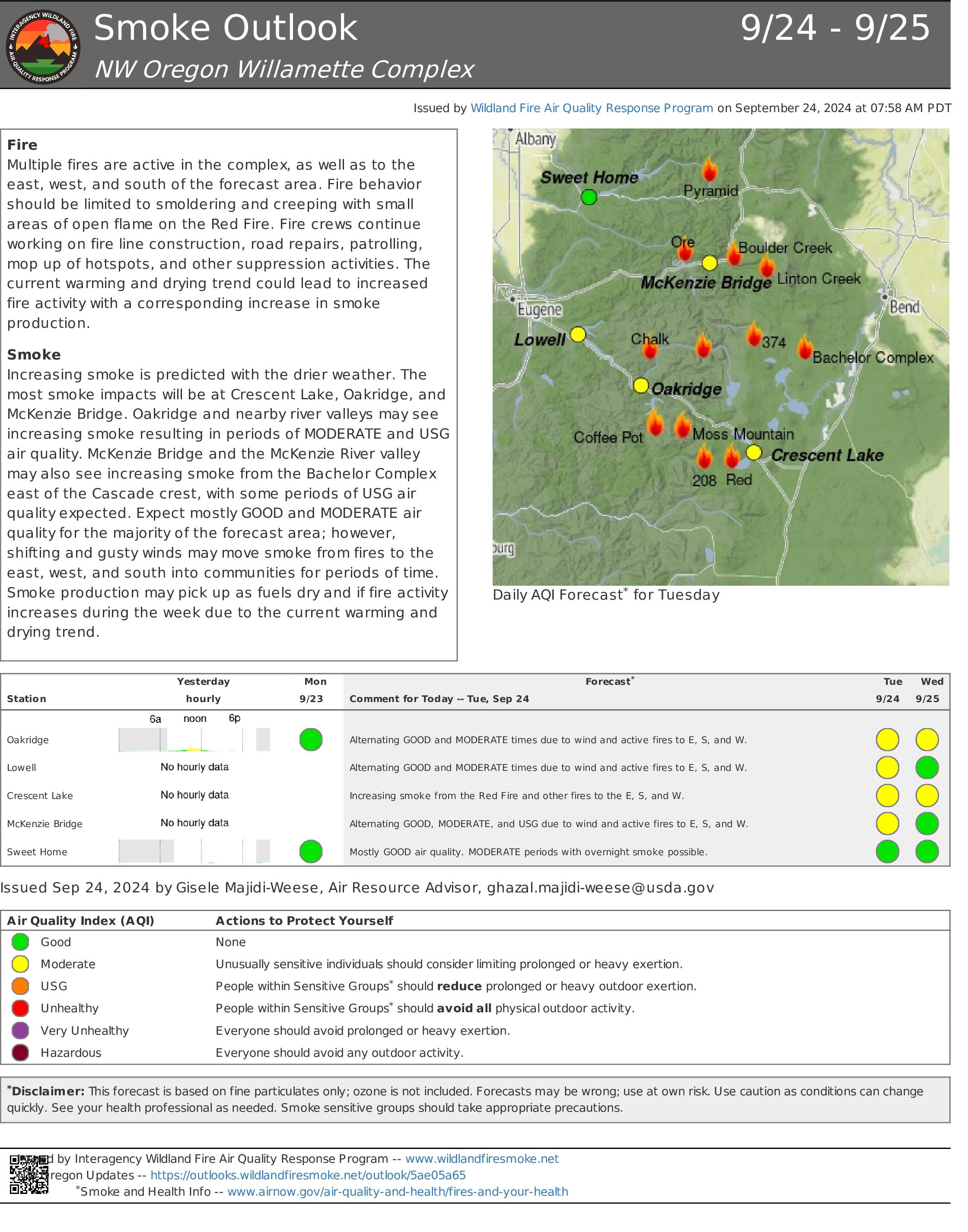
Overview: Shifting winds have the potential to bring down fire-weakened trees in the fire areas today. Please avoid entering the fire closure areas. Warmer and drier conditions are predicted for today with temperatures reaching the 80s in the fire areas and up to 90 in the valleys. Wind gusts could reach 25 mph, which could facilitate fire spread between heavy fuels and down logs where areas of heat remain in the interior of the fire areas. Fuel moistures should limit fire activity to smoldering and wind-driven spread. Firefighters are prepared for this change in weather and will address any increased fire activity and hold fire containment lines. There may be an increase in smoke today. Wednesday is expected to bring increased humidity and cooler temperatures.
Willamette National Forest Area Closures: An adjusted closure order for the Pyramid Fire was signed yesterday, reducing the closed area and allowing additional recreation and hunting opportunities within the Middle Santiam Wilderness. Forest officials are continually evaluating closure orders and will adjust as conditions allow. Other fire-related closures remain in place on the McKenzie River Ranger District, as well as on the Middle Fork Ranger District in the immediate fire operations area for public and firefighter safety. Please respect and avoid all closed areas of the national forest. Source: https://www.fs.usda.gov/detail/willamette/fire/?cid=fseprd552029
Boulder Creek: 523 acres, 34% contained Located 5 miles east of McKenzie Bridge. Crews are gridding and mopping up to extinguish areas of heat in the interior of the fire and are continuing to masticate and chip vegetative materials along the containment lines. Fire activity is expected to be minimal with creeping, smoldering, and consumption of interior heavy fuels.
Ore: 3,484 acres, 80% contained Located 7 miles northeast of Blue River. Firefighters are focusing on suppression repair within the fire area and backhauling firefighting equipment and hose. Last night’s infrared imaging showed minimal heat only in the interior of the fire. Fire behavior may pick up in some interior pockets, but minimal growth is expected.
Pyramid: 1,312 Acres, 100% contained East of Middle Santiam Wilderness. This fire is now fully contained. Crews are continuing with suppression repairs on trails and working with heavy equipment. Fire activity is predicted to remain minimal.
374: 62 acres, 0% contained and Linton Creek: 1,309 acres, 0% contained Located in the Three Sisters Wilderness. Wind gusts are predicted for ridgetops in these fire areas. These fires are showing scattered heat but are adjacent to natural barriers and previous fire scars. Fire activity could increase with today’s weather and some wind-driven fire spread is possible. These fires will be monitored with additional suppression actions taken if needed. Increased smoke production is expected.
Road Closures: OR-242 remains closed to all traffic between the intersection with OR-126 and the Dee Wright Observatory (mileposts 55 to 75). For current road conditions, please check Oregon Department of Transportation’s website: https://www.tripcheck.com/
Rail Ridge and Wiley Flat Fire Daily Update 09 24 2024
Related Incident:
Publication Type: News
Rail Ridge and Wiley Flat Fire Daily Update
9-24-24
Rail Ridge Fire
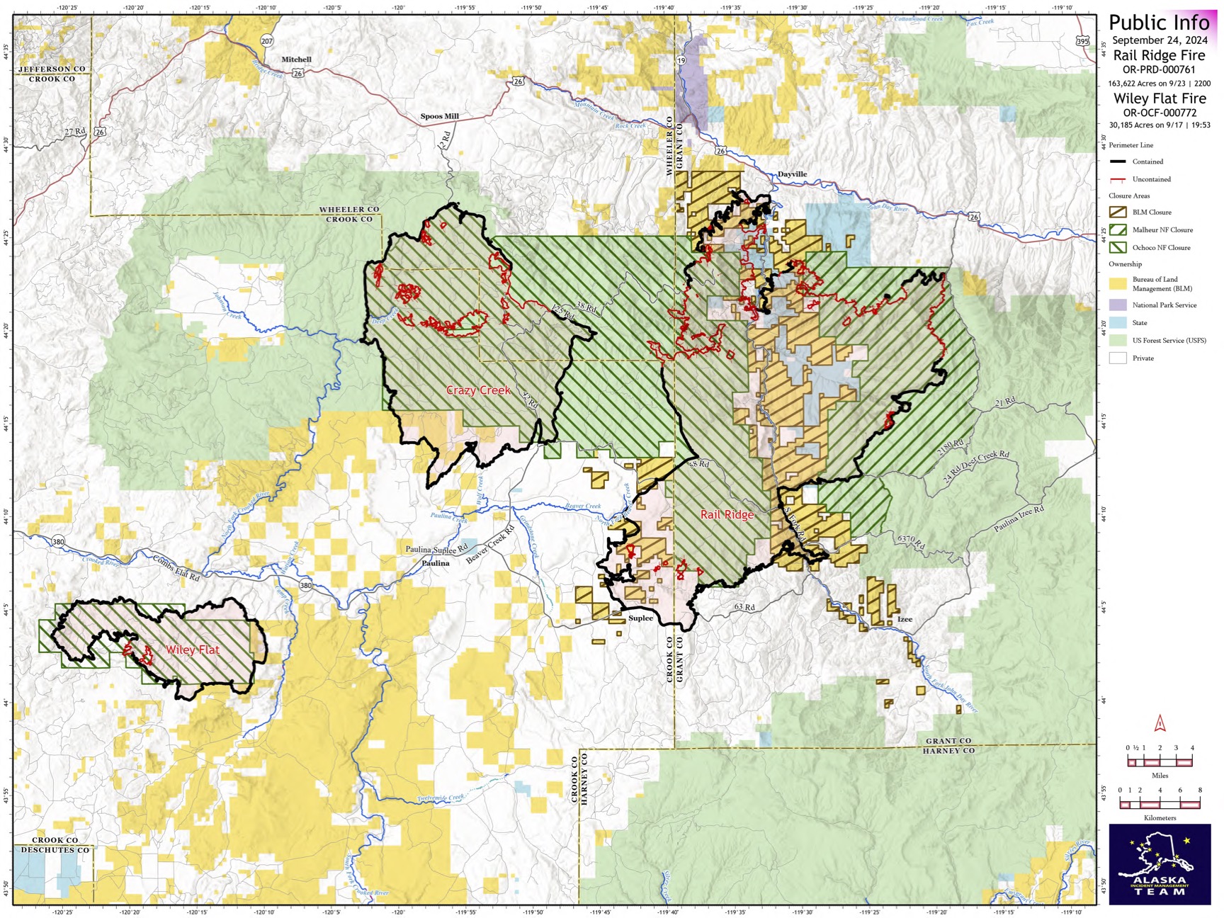
Acres: 163,622 – Containment: 59% – Detection Date: Sept 2, 2024 – Cause: Lightning – Total resources: 1291
Operational Update: Crews working on the northeastern corner of the Rail Ridge Fire are conducting burn out operations to secure containment line in the area of the Black Canyon Wilderness. Line construction and improvement is ongoing around the perimeter of the fire as well as road rehabilitation and suppression repair. The Bureau of Land Management and U.S. Forest Service are working cooperatively with the Oregon Department of Forestry to prioritize and complete suppression repair on federal, state and private lands. Landowners can submit a request for suppression repair assistance here: https://tinyurl.com/RailRidgeRepair
The Malheur National Forest has reduced the area closure for the Rail Ridge Fire on the Blue Mountain Ranger District. This closure update will be effective September 24, 2024, through December 31, 2024, unless rescinded sooner. For map and more information, visit: https://bit.ly/MalheurRRClosure
Wiley Flat Fire
Acres: 30,186 – Containment: 94% – Detection Date: Sept 2, 2024 – Cause: Lightning – Total resources: 109
Operational Update: Mop up and suppression repair is ongoing around the Wiley Flat Fire as crews work towards 100% containment. A Burned Area Emergency Response (BAER) team is establishing a long-term plan for suppression repair and road rehabilitation across the Wiley Fire.
Weather: Elevated temperatures and lower relative humidities with gusting winds are expected throughout this week. This could produce an increase in fire activity inside of containment lines, as well as more visible smoke in the area.
Evacuations
Rail Ridge Evacuations: All level 1 and 2 evacuation zones have been lifted for Grant County, and level 3 zones have been downgraded to level 2 “set” status.
Wiley Flat Evacuations: All areas inside the fire perimeter are designated Level 3 Evacuation zones. The area encompassing approximately one-half mile from the fire perimeter is designated Level 2 evacuation zone.
For Current Evacuation Levels in Wheeler, Crook and Grant counties, please visit: https://linktr.ee/RailRidgeFire
Closures
The U.S. Forest Service and Bureau of Land Management have implemented closures for the Rail Ridge and Wiley Flat Fires. For more details and closure maps, visit https://linktr.ee/RailRidgeFire
#RailRidgeFire2024 #WileyFlatFire2024 #FireYear2024

West Fire Update 09 24 2024
Related Incident: 2024 - West Fire - TNF
Publication Type: News
Planned perimeter ignitions completed; large scale ignitions completed
Highlights/Operations: Large scale ignitions are complete on the West Fire as the incident transitions to a local incident management organization. Today at 6 p.m. the Southwest Incident Management Team 3 will transfer command of the West and Preacher Fires to Type 3 Incident Commander Tadd Fagerud.
Yesterday additional sections of the northwest corner of the perimeter were contained as engines found no significant heat. Crews igniting by hand worked south along the dozer line just east of Pine and west along the Control Road until they connected their firing operations. Aerial ignitions assisted by applying fire above the Pine trailhead. Across the rest of the fire area engines and crews focused on mop up, patrol and backhaul of equipment. Heavy equipment is still repairing some of the contingency lines created to the east of the fire, and a road grader is working on the Control Road.
Today, firefighters are mopping up any ignitions from yesterday and last night. Unburned pockets within the containment area may continue to produce smoke. Beginning this morning, the Control Road will be open to residents only heading both east and west from Geronimo Estates. Use caution when driving as there could be periods where smoke is present, and visibility reduced. In addition, there will be a presence of firefighter patrolling and working along the roadway.
Weather: Warm and dry weather conditions will continue Tuesday and Wednesday. Highs in the mid-70s to upper 80s both days. Minimum relative humidity levels will average 15-25%. Winds will be light out the of east northeast on Tuesday and west southwest on Wednesday.
Safety: The Temporary Flight Restriction (TFR) will expire at midnight tonight.
Closure: The Tonto National Forest has issued a closure for land surrounding the West Fire, this includes Pine Trailhead.
Evacuations: Pine residents on the east side of SR 87 and east of North Pine Creek Canyon road are in SET status. Geronimo Estates residents near the West Fire are in SET status. An interactive map is available to stay up to date with evacuation levels related to both the West and Preacher Fires.
Receive emergency notifications from Gila County.
Smoke: During ignitions, smoke may settle in low-lying areas overnight. Residents are encouraged to close windows at night to avoid smoke impacts. Talk with your doctor and plan for how to manage your health conditions when it is smoky. Additional resources for how to prepare for wildfire smoke.
For the latest news and information about the Tonto National Forest, follow along on Facebook @TontoNationalForest, ‘X’ (formerly Twitter) @TontoForest or Instagram @tontonationalforest and on the Tonto National Forest website: https://www.fs.usda.gov/tonto