
Incident Publication
Whisky Creek Fire update 09 21 2024
Related Incident: Whisky Creek Fire
Publication Type: News
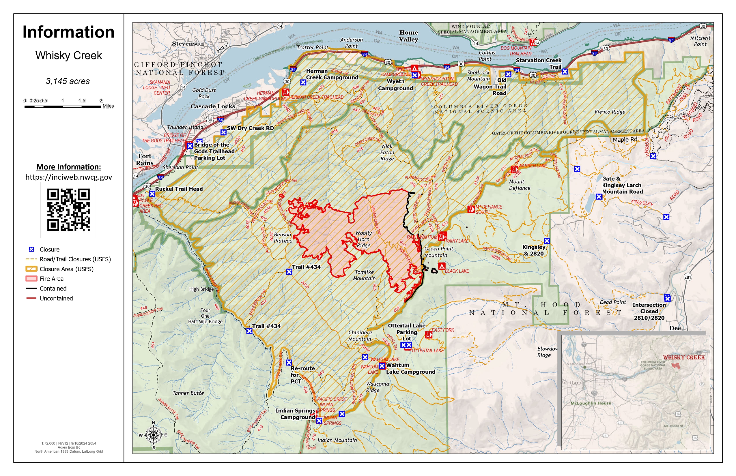
Whisky Creek Size: 3,169 acres | Start Date: July 20 | Cause: Human | Containment: 25%
Total Resources: 72 | Hand Crews: 3 | Engines: 3 | Water Tenders: 2 | Heavy Equipment:2
The Whisky Creek Fire is in steep and rugged terrain within the Mark O. Hatfield Wilderness in the Mt. Hood National Forest. The fire remains within the control lines along the southern and eastern edge. The Eagle Creek Fire scar continues to be a barrier along the western and northern edges of the fire.
All fire growth has been along the southern edge of the fire and poses no threat to control lines. The fire is still smoldering in heavy logs and will continue to produce light smoke. Fire behavior is not expected to increase even with sunnier, warmer weather moving into the area.
Yesterday, hand crews removed compromised trees near the intersection of Forest Road 2820 and Forest Trail 409b. Resource Advisors accompanied firefighters as they set out to scout a helispot in the wilderness above Rainy Lake that was used during fire suppression efforts. Once found, they were able to identify the repairs necessary to restore the area.
Weather: High pressures will help maintain dry weather with seasonal temperatures through Saturday. Light off-shore easterly winds will occur which will most likely cause smoke to increase in the area. Humidity recoveries will remain good to excellent. This pattern should continue throughout the day.
For smoke forecasts and safety, visit: oregonsmoke.org.
Closures: Area closures remain in the Mt. Hood National Forest, Columbia River Gorge National Scenic Area, and Hood River County. Closures are put into place for the safety of the public and fire crews; intrusion into a closure area can disrupt fire suppression and repair activities, endanger lives and property, and can result in fines. Closure information is at: https://linktr.ee/whisky_creek.2024.
Safety: The public plays an important role in preventing the next wildfire; please use caution with all potential ignition sources. For prevention tips see: https://keeporegongreen.org. The Temporary Flight Restriction remains in effect for the Whisky Fire: https://tinyurl.com/2s49yrj4.
Rail Ridge and Wiley Flat Fire Daily Update 09 21 2024
Related Incident:
Publication Type: News
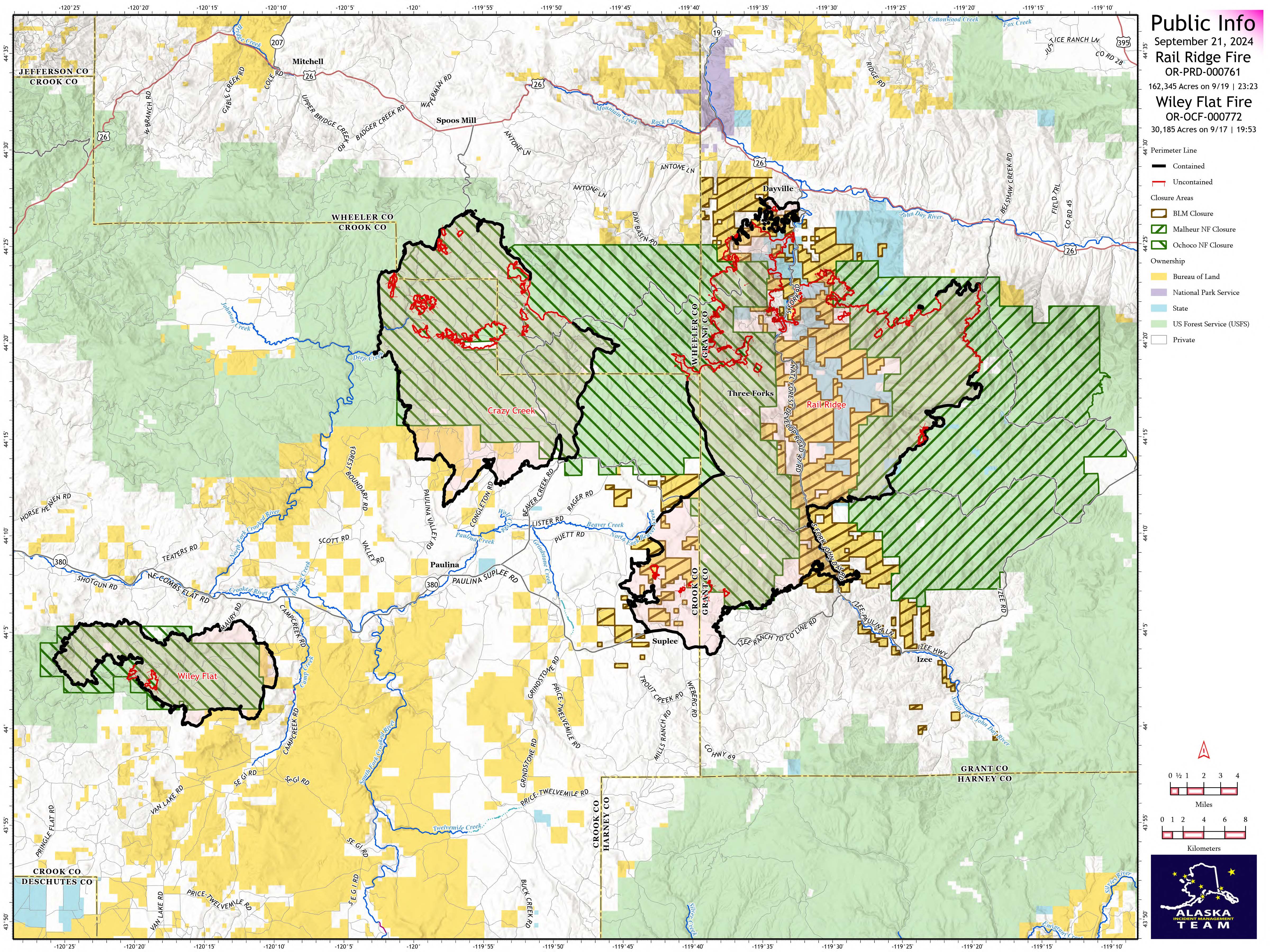
Rail Ridge and Wiley Flat Fire Daily Update 9-21-24
Rail Ridge Fire
Acres: 162,345- Containment: 50% - Detection Date: Sept 2, 2024 - Cause: Lightning - Total resources: 1,406
Operational Update
Crews: 41 - Engines: 66 - Dozers: 20 - Helicopters: 13
Phone: 541-208-7111 - Email: 2024.railridge@firenet.gov
There was an uptick in interior fire activity yesterday afternoon as temperatures and relative humidities returned to normal seasonal warm and dry conditions, with gusting winds across the fire area. An increase of activity in the Black Canyon Wilderness created a visible smoke column during the early afternoon. Ongoing line construction and the establishment of shaded fuel breaks on the northern edge of the fire will ensure secure containment if fire behavior increases with similar wind and weather conditions predicted for next week.
Crews continue to strengthen suppression lines and implement suppression repair activities along the southern edge of the fire. Road repair is also ongoing on the southern portion of the fire.
Wiley Flat Fire
Acres: 30,186 - Containment: 94% - Detection Date: Sept 2, 2024 - Cause: Lightning - Total resources: 168
Crews: 3 - Engines: 3 - Dozers: 2
Phone: 541-208-7108 - Email: 2024.wileyflat@firenet.gov
Operational Update
Firefighters continue to implement suppression repair measures around the fire perimeter, working to achieve repair standards established for sensitive areas within the fire footprint, as well as repairing roads that have been impacted by fire suppression efforts. Crews continue to monitor for any residual heat.
Closures and Evacuations
Rail Ridge Evacuations: All level 1 and 2 evacuation zones have been lifted for Grant County, and level 3 zones have been downgraded to level 2 “set” status. For Crook and Wheeler counties, all evacuation statuses have been lifted.
Wiley Flat Evacuations: All areas inside the fire perimeter are designated Level 3 Evacuation zones The area encompassing approximately one-half mile from the fire perimeter is designated Level 2 evacuation zone.
For Current Evacuation Levels in all counties, please visit: https://linktr.ee/RailRidgeFire
Closures: The U.S. Forest Service and Bureau of Land Management have implemented closures for the Rail Ridge and Wiley Flat Fires. For more details and closure maps, visit https://linktr.ee/RailRidgeFire
#railridgefire2024 #wileyflatfire2024 #fireyear2024

Umpqua National Forest Terminates Public Use Restrictions and Decreases to Moderate Fire Danger on 09202024 09 20 2024
Related Incident: Lane 1 Fire
Publication Type: Announcement
Starting at 12:01 am, Friday, September 20, 2024, Umpqua National Forest is terminating Public Use Restrictions (PURs) and decreasing to Moderate Fire Danger across all districts. Beginning at 12:01 am on Monday, September 23, 2024, the forest will move to Industrial Fire Precaution Level 1 (IFPL).
Removing PURs across the forest means that there are no longer restrictions on campfires, stoves, smoking, generators, or motorized vehicles. Please remember that all campfires need to be dead out before leaving your campsite. Drown, stir, and feel your campfire with the back of your hand. It should feel cold to the touch.
Industrial Fire Precaution Level 1 begins on Monday, September 23, 2024, which means it is Closed Season with the following fire precaution requirements:
- Fire tools must be on site.
- Fire extinguisher and shovel must be with each chainsaw.
- Fire extinguishers must be in all vehicles.
- Chainsaws must have a .023-inch mesh screen installed in the exhaust.
- Approved spark arresters must be on all internal combustion engines.
- No smoking is permitted while working or traveling through any operations area on public land except while in enclosed vehicles.
- Permits to burn are required unless waived in advance.
A Fire Watch is required at this level unless otherwise waived. The Watchman must be:
- Physically capable and experienced in operating any firefighting equipment on site.
- On duty for 1 hour after the shutdown of the last power-driven equipment for the day unless otherwise specified.
- Furnished with adequate facilities for transportation and communications in order to summon if needed.
- Patrolling and visually inspecting all sites where work was done during the day.
For more information on PURs, IFPLs, or other fire management information, visit: https://www.fs.usda.gov/main/umpqua/fire.
Homestead Complex and Lane 1 Fire Daily Update 09 21 2024
Related Incident: Lane 1 Fire
Publication Type: News
Email: 2024.homesteadcomplex@firenet.gov
Fire Information Line: 541-208-7100 (Staffed 8 a.m. to 8 p.m.)
Facebook: https://t.ly/mSLvP
Inciweb: https://t.ly/syeHa
September 21, 2024
Firefighters are using direct and indirect tactics to suppress eight fires, totaling approximately 35,709 acres. The Lane 1 fire is 99% contained. The Homestead Complex of fires is 33% contained overall. 766 people are assigned to the Homestead Complex and Lane 1 fires.
Crews are improving containment lines across the fire area by reducing fuels through mastication, chipping wood, and hauling fuels to landings away from the fire. There are still many miles of uncontained fire edge. Aerial infrared detection yesterday located additional hot spots that crews will address today. Firefighters are mopping up, widening and strengthening fire lines by extinguishing hot spots and removing fuels. A large helicopter yesterday supported firefighters on the ground, dropping 2,900 gallons of water. Crews are also clearing and repairing roads impacted by the fires and by fire suppression activities. The goal of these fire suppression and repair efforts is to protect the values at risk: communities and infrastructure; private timber lands; and public resources, including recreation opportunities and fish spawning habitat.
On the Horse Heaven Fire, firefighters found a spot fire yesterday at the northeast corner, based on seeing smoke. They got line around the spot and got it contained. Hand crews are working in that area, near the 915 road spur, and engines are supporting where they have access. The large chipping operation continues along the east flank of the fire. On the west flank, a masticator is removing fuels along the indirect fire line.
On the Fuller Lake and Bullpup Fires, firefighters yesterday improved fire line around a slop-over and spot fire near the 380 and 3810 roads, to ensure they stay in check with the warmer, drier weather. Moving south on the 3810 road, a processor is pulling logs out, then a masticator is working behind on the indirect fire line along the Boulder Creek Wilderness. On the east flank of the fire, along the 5851 road, firefighters are extinguishing hot spots and mopping up, confirming fire lines stay secure with the weather change.
On the No Man Fire, infrared detection showed some new heat on the west flank, inside the fire line. Crews engaged the hot spots yesterday and will monitor those spots today. Two excavators are working at the south flank and engines are patrolling the indirect fire perimeter lines.
On the Lane 1 Fire, crews completed snagging on the north flank yesterday. Heavy equipment continues work today on the 900 and 2328 roads and near Canton Creek, cleaning out ditches, grading, and installing water bars. Crews are consolidating log decks at the southeast fire edge. Hauling, chipping, and a hand crew will follow that work. Firefighters are evaluating structure protections in place near the Bohemia Mine District to determine what equipment is no longer needed and could be removed as fire risk decreases. On the east flank, crews are replacing berms and drainage features on previous roadbeds that were opened for dozer line.
Closures and fire restrictions: Two closure orders impact every District of the Umpqua National Forest https://t.ly/Mvn6G. The forest is in Moderate Fire Danger with no Public Use Restrictions https://t.ly/LI4cd. A Bureau of Land Management (BLM) Roseburg District closure order is in effect for portions of BLM land bordering the Umpqua National Forest closure north of Steamboat https://t.ly/uWX6l. A BLM Northwest Oregon District closure is also in place for an area west of the Lane 1 fire https://t.ly/oW1lG.
Weather: The Incident Meteorologist is predicting the weather today will be warmer and drier. A warming and drying trend continues in the forecast, reaching into the 80s on Tuesday, with relative humidities dipping to 27 percent. As fuels dry out, there is increased potential for some fire spread and additional smoke.
Bridge Fire Morning Update 09 21 2024
Related Incident: Bridge Fire
Publication Type: News
Unified Command: CIIMT5, Los Angeles County Fire, Los Angeles County Sheriff, San Bernardino County Sheriff, CAL FIRE – San Bernardino/Inyo/Mono Unit
Start Date: September 8, 2024, at 2:12 p.m.
Fire Information: (626) 662-0120
Media Line: (626) 470-1395
Hours: 7:00 a.m. to 9:00 p.m.
Email: 2024.Bridge@firenet.gov
Fire Size: 54,795 acres
Percent Contained: 65%
Personnel: 1,910
Injuries: 5
Structures Damaged: 17
Structures Destroyed: 81
Cause: Under investigation
Location: Sheep Mountain Wilderness, San Gabriel Mountains National Monument
CURRENT SITUATION: Today, firefighters will continue mop-up efforts across the fire, securing containment lines, extinguishing isolated heat sources, and felling hazardous trees to improve public and crew safety. Crews on the west flank will focus on constructing indirect line from Rattlesnake Peak north and Mount Baden Powell south – tying in containment lines at Mount Hawkins. On the south flank, aircraft dropping fire retardant will work with ground crews on the remaining open portion of containment line to get that area buttoned up.
Members of the public returning to fire-impacted areas in and around Wrightwood are asked to return any fire equipment found on their properties to San Bernardino County Fire Station 14 at 5980 Elm St., Wrightwood, Calif., 92397. Please do not take items to Wrightwood Elementary School.
A Forest Order will close portions of the Angeles National Forest at 12:00 a.m. today, Sept. 21, 2024. The Order closing the Bridge Fire area is available in local U.S. Forest Service offices and online at: https://www.fs.usda.gov/angeles
Damage inspection teams have completed their inspections. Residents affected by the Bridge Fire at:
For San Bernardino County: prepare.sbcounty.gov/bridge-fire/
For Los Angeles County: recovery.lacounty.gov/bridgefire/
Local Assistance Centers:
Los Angeles and San Bernadino Counties are working together to provide assistance to residents affected by the recent Bridge and Line Fires. The purpose of the LAC is to provide a one-stop center where individuals, family members, and business owners may obtain information on services and assistance needed because of a disaster or damage to personal property.
https://recovery.lacounty.gov/wp-content/uploads/2024/09/Bridge-and-Line-Fire-LAC-Final-Updated.pdf
Evacuation Order:
- The area of Mile High
Evacuation Warning:
- Bear Canyon
- East Fork communities of Camp Williams Resort and River Community
For Interactive maps on evacuations:
- Los Angeles County: Genasys Protect website or download the app. https://protect.genasys.com
- San Bernadino: https://sbcounty.maps.arcgis.com
For emergency alerts, please register here:
- Los Angeles County: https://ready.lacounty.gov/emergency-notifications/
- San Bernardino County: https://wp.sbcounty.gov/sheriff/alerts/
Evacuation Centers:
- San Bernardino County Fairgrounds: 14800 Seventh Street, Victorville, CA
Animals:
- Devore Animal Shelter: 19777 Shelter Way, San Bernardino, CA. (909) 386-9820. After hours: (800) 472-5609
- San Bernardino County Fairgrounds: 14800 Seventh Street, Victorville, CA
- Palmdale Animal Care Center (Small Animals): 38550 Sierra Hwy, Palmdale, CA
- Lancaster Animal Care Center (Small Animals): 5210 W Ave I, Lancaster, CA
For more information on evacuation centers:
- www.redcross.org/get-help/disaster-relief-and-recovery-services/find-an-open-shelter.html
- https://lacounty.gov/emergency/
ROAD CLOSURES:
- Big Pines Highway
- Big Rock Creek Road
- Largo Vista Road
- Mescal Creek Road
- Panorama Motorway
- SR-39 at the base of San Gabriel Canyon (residents of Camp Williams and River Community only)
- Glendora Mountain Road north of Big Dalton Road
- SR-2 at Flume Canyon Road westbound
WEATHER:
The area will see a warming and drying trend as a high-pressure system from the Pacific Ocean moves in. The marine layer will dissipate by early to mid-week, and relative humidities will drop, leading to elevated fire danger. Then warmer, drier weather is expected to last through the end of the month.
Pearl Fire Daily Update 09 21 2024
Related Incident:
Publication Type: Announcement
FORT COLLINS, Colo. (Sept. 21, 2024) – The Pearl Fire remains estimated at 128 acres with 75% containment. Containment continues to increase as fire crews are focused on reinforcing control lines, mopping up, and returning disturbed areas to a more natural state.
The weather is expected to remain warm and dry this morning, with cloud cover increasing through the day. Rain and cooler temperatures are expected in the evening with several inches of snow possible by Sunday morning. As conditions become more favorable, the Incident Management Team is beginning to reduce the number of resources assigned to the fire.
When returning to the area, the public is asked to adhere to any forest or road closures and be aware of emergency personnel. To protect public health and safety during an active wildfire, the Forest Service has issued a closure order for the immediate fire area. The Forest Service remains in Stage 1 fire restrictions. Refer to the Arapaho and Roosevelt National Forests website for more information.
Larimer County Sheriff's Office closed the Joint Information Center on Thursday, Sept. 19 and does not plan to reopen. Multiple evacuation orders have been lifted. To view updates and orders visit the Larimer County Website. To view a current map of evacuation zones and roadblocks, visit NOCO Alert.
Maps and other details for the Pearl Fire can be found on InciWeb. For the latest updates, follow us on Facebook and X. To receive email updates on this fire, join our email list and select Forest Health & Fire: North of Hwy 14 to Wyoming Border (Red Feather Lakes).
West and Preacher Fires Update 09 21 2024
Related Incident: 2024 - West Fire - TNF2024 - Preacher Fire - TNF
Publication Type: News
Ignitions on West fire anticipated to continue into the weekend
Highlights/Operations: Firefighters look to complete their ignition plans on the West Fire over the next 48 hours. Yesterday, crews ignited down the Webber Road and worked towards the west on the Control Road. Ignitions continued along the Control Road north of Geronimo Estates. Overnight crews carefully worked to bring fire down the dozer line just east of Pine and southwest along the Control Road when relative humidities were higher. Firefighters also used chainsaws to remove dead trees around Camp Geronimo, making the camp safer for future public use.
Today conditions are expected to be favorable for ignitions. Firefighters will work to ignite along the perimeter east of Pine and along the Control Road towards SR 87. Residents of east Pine may see the glow of fire at night and increased smoke. Around Camp Geronimo, engines are extinguishing any hot spots. On the east side of the West Fire, crews are continuing to backhaul equipment and assessing needs for repair work. Road graders are fixing washboards along the Control Road to the east.
Weather: Saturday will feature a partly sunny sky. A couple of showers are forecast as a possibility through the morning hours that could produce a few hundredths of an inch on rain. High temperatures from 72 to 80 degrees, except 60 degrees on top of the rim. Winds are forecast to be west at 4 to 8 mph with gusts of 15 to 18 mph. Minimum humidity levels will range between 30 and 40%. Warmer and drier temperatures are forecast on Sunday.
Safety: A Temporary Flight Restriction (TFR) is in place over the West fire area, which includes uncrewed aircraft systems or drones. Reminder that if you fly we can’t, unauthorized drone flights pose serious risks to firefighter and public safety and the effectiveness of wildfire suppression operations.
Closure: The Tonto National Forest has issued a closure for land surrounding the West Fire, this includes Pine Trailhead.
Evacuations: Pine residents on the east side of SR 87 and east of North Pine Creek Canyon road are in SET status. Geronimo Estates residents near the West Fire are in SET status. An interactive map is available to stay up to date with evacuation levels related to both the West and Preacher Fires.
Receive emergency notifications from Gila County.
Smoke: During ignitions, smoke may settle in low-lying areas overnight. Residents are encouraged to close windows at night to avoid smoke impacts. Talk with your doctor and plan for how to manage your health conditions when it is smoky. Additional resources for how to prepare for wildfire smoke.
For the latest news and information about the Tonto National Forest, follow along on Facebook @TontoNationalForest, ‘X’ (formerly Twitter) @TontoForest or Instagram @tontonationalforest and on the Tonto National Forest website.
Fossil Complex Daily Update 9212024 09 21 2024
Related Incident: Fossil Complex
Publication Type: News
Fossil Complex Crews Divide Work For Mop Up and Repair
FOSSIL, Ore. – Crews on the Service Fire will divide work between mop up along containment lines and repairing damage from the fire suppression efforts.
Crews on the north side of the Service Fire will work to complete mop up and hauling equipment off the fire line. Containment is 300 feet deep in these areas. The south and southwest of the fire will continue to deepen the cold black area to 300 feet while removing and returning equipment from the fire lines.
Suppression crews will work to repair dozer lines, install water bars to roads and repair or replace any fencing damaged during firefighting efforts. The crews will scout the interior of the fire to identify areas of work and map them for repair later. Spike camps in Long Creek and at the Morrow County OHV park are working on suppression repair on the Battle Mountain Complex and Lonerock Fire scar areas.
Today will be slightly warmer, but starting cooler than yesterday. Winds will be light out of the east and relative humidity in the lower 20s.
With fall almost there, deer are reminded to be aware that crews are moving around the fire at all times. Take caution when crossing roads, especially ORE 19 where vehicles are moving at a high rate of speed.
All evacuation levels for the Service Fire have been lifted and all zones have been placed into "Normal" status. The Two Cabin, Holmes, Kinzua and Canyon Fires are all in patrol status.
Videos: Recordings of the Daily Operations Updates and other stories are available at: https://www.youtube.com/@FossilComplex.
Diamond Complex Update 09 21 2024
Related Incident:
Publication Type: News
Current Situation: The warming and drying trend continues to bring sunny skies and increased temperatures throughout the fire area. The favorable weather conditions have allowed personnel to continue making progress toward completing fire-suppression repair tasks across the Diamond Complex. While fire-suppression repair remains the incident priority, personnel and equipment are also poised to ensure all fires stay within containment lines and stand ready to respond to any new fires within the Umpqua National Forest.
On Friday, several reconnaissance fights were conducted to survey the fires within the Diamond Complex for any sources of smoke, heat, or areas of concern. Only a few pockets of heat and single smoldering trees were located. A helicopter was utilized for several water-dropping missions to extinguish a few stubborn hotspots on the Potter Fire that have resurfaced with the increase in temperatures and lower humidity.
Every shift, crews and equipment get their assignments and drive to their various divisions across the Diamond Complex. These personnel have become intimately involved with the sections of the fire they have been assigned to. Over the past several weeks, many of them have transitioned from fire attack to fire-suppression repair operations where they must now return the forest to as much of a normal state as practical. Firefighters will continue repairing handlines by pulling back the removed material onto the line as well as building water bars to assist with erosion control. Dozer-constructed lines will continue to be repaired by heavy-equipment, like excavators, by placing the removed natural vegetation back onto the lines to protect the soil and make it easier for the ground to recover. Crews will continue hauling and chipping slash material from hazard tree removal operations. Road grading operations continue on the forest roads that have been damaged by firefighting equipment and heavy machinery throughout the incident. Along the southern edge of the Potter Fire, the operation of laying and grading several hundred yards of gravel on the 100 Road has been completed. As personnel complete identified suppression-repair items, resource advisors are approving each project to verify it has met the Forest’s repair standards.
The Diamond Complex includes 33 fires in the Umpqua National Forest, 31 of which are 100% contained. The remaining two fires that are not fully contained are the Pine Bench Fire (3,976 acres, 68% contained) and the Potter Fire (3,428 acres, 78% contained).
Forest Closure: Umpqua National Forest lands, roads, and trails around the Diamond Complex fires are temporarily closed (with several exemptions) under Forest Order 06-15-24-07. You are responsible for knowing where you are in relation to the closed areas, so be prepared and view the order and map prior to recreating on your public lands.
Fire Restrictions: As of Friday, September 20, 2024, the Umpqua National Forest has terminated Public Use Restrictions (PURs) and has decreased to Moderate Fire Danger across all districts. Beginning at 12:01 a.m. on Monday, September 23, 2024, the forest will move to Industrial Fire Precaution Level (IFPL) 1.
Size: 11,141 acres
Containment: 90%
Personnel: 316
Resources: 7 crews | 1 helicopter | 6 engines | 4 dozers | 12 water tenders | 2 masticators | 9 excavators
###
Next update to be released 9-23-2024
Lava Fire Daily Update September 21 2024 09 21 2024
Related Incident:
Publication Type: News
Evacuations orders have been downgraded for Valley County residents effective yesterday September 20, 2024 (see below).
Overview: The Lava Fire is on the Boise and Payette National Forests and lands administered by the Bureau of Land Management and the Idaho Department of Lands. The fire is located north of Emmett and west of Lake Cascade and started by lightning on Monday, September 2. It is burning in tall grass, brush, and timber.
The Lava Fire is currently 97,934 acres with 61 percent of the perimeter contained. 617 personnel are assigned, including 12 crews, 1 large helicopter, 1 small helicopter, 27 engines, 10 bulldozers, 9 water tenders, 7 excavators, 1 skidder and 8 ambulances.
Property remaining in an area that is evacuated or impacted by Forest Service closures must remain until fire managers, Sheriff’s departments, and emergency management departments deem the area is safe for reentry.
Operations: Yesterday, unmanned aircraft system (drone) pilots identified heat scattered within the interior eastern perimeter of the fire line. Minimal smoke was observed in isolated, shady timbered areas in the interior but does not threaten constructed lines. In the eastern flank, chippers reduced burnable vegetation along Forest Service Road 446E and Gopher Road. Firefighters continued to backhaul excess equipment and patrol and mop up as needed. Firefighters constructed direct line along the fire edge in the northern flank from Little Weiser Creek working east and working west from Forest Service Roads 835 to 231. Crews removed hazardous limbs along Forest Service Roads 425, 206, and 835. Bulldozer line was completed near God’s Acres and Cascade Christian Church Camp. Firefighters worked alongside resource advisors to complete suppression repair along bulldozer lines. On the western flank, crews extinguished slopovers along bulldozer lines and worked with resource advisors to repair any damages that may have occurred along that fire edge. Firefighters graded 9 miles of road from Sheep Creek Road north to Shirts Creek Road. They worked with resource advisors in the interior to assess additional needs. Crews continued to monitor the southern flank near the Gross community. Firefighters constructed direct and indirect line along Forest Service Road 653. A Lava Fire informational meeting was held yesterday at the Ola Community Hall and 25 people attended.
Today, firefighters continue to work alongside resource advisors in all areas to carry out and assess suppression repair needs to return areas to pre-fire conditions.
On the northern flank, firefighters continue to remove hazardous trees on Forest Service Roads 435, 206, and 835 to allow safe access to interior handlines. Crews continue to build direct line east along the fire edge towards Anderson Creek until it meets with a bulldozer line constructed from the north.
On the eastern flank, chipping will reduce thick, burnable vegetation on Forest Service Roads 446E and Gopher Road. Crews will patrol Forest Service Road 404 and extinguish any heat sources they find focusing on a depth of 100 feet from the line. Firefighters will repair bulldozer lines and assess equipment needs such as a road repair graders. Firefighters will begin grading roadways between Campbell Creek boat ramp and God’s Acre.
On the southern flank, firefighters continue to monitor fire activity near the Gross Community, ready to respond if necessary. Crews are constructing direct and indirect handline northeast along Forest Service Road 653. They will install fire hose to the north of Sage Hen Reservoir and Forest Service Road 626 to prevent potential fire spreading. Crews will move graders that worked along the western flank yesterday to the southern flank to repair roadways today.
On the western flank, crews will extinguish heat that was detected by infrared drones along the containment lines near Forest Service Road 208. Firefighters will work in the southwest to repair bulldozer line that was installed for containment.
Weather/Fire Behavior: Another dry and fair day is forecasted today. Minimal cloud cover will provide little to no shade across the fire. Seasonal temperatures will be closer to what is expected in the high 60s. Relative humidity percent continues to dip and is expected to be in the 20s. Wind will start in the north and shift to northwest winds in the afternoon and evening. Wind speeds are forecasted to be 7-12 mph with maximum wind gusts in the mid to upper teens mph. Firefighters will continue to watch for new ignitions from recent lightning that may ignite under sunny conditions.
Evacuations: Adams County Sheriff’s Office downgraded to a Level 1 “READY” for residents south of South Grays Creek, along Little Weiser River Road in Indian Valley, North of South Grays Creek Road to Highway 95, and the Mesa Area. These evacuations notices are effective as of Tuesday, September 17, 2024.
Valley County Sheriff’s Office removed Zones 2 & 3 from LEVEL 1 “READY” status. Zones 4 – 6 remain in a LEVEL 1 “READY” Evacuation notice. All remaining zones have been removed from any evacuation status for the Lava Fire effective Tuesday, September 17, 2024.
Closures and Restrictions: The Boise and Payette National Forests implemented a joint Lava Fire Area, Road, and Trail Closure for public and firefighter safety. The southern portion of this closure area follows roads 601 (which remains closed) and 644 (which remains open). The northern boundary follows a portion of the Payette National Forest’s road 186 (open) and crosses over to the Boise National Forest just south of trail 116. Snowbank Road (446) and Sage Hen Reservoir area remain closed, French Creek Campground remains open. This closure adjustment became effective on September 19, 2024, at 10:00 a.m.
Gem County Road and Bridge issued the following road closures: Third Fork Road at Nesbitt Lane, Second Fork Road at Nesbitt Lane, and Nesbitt Lane. The Sweet-Ola Highway is closed at the High Valley intersection in Ola. Please be advised that the Gem County Sheriff’s Office is staffing the road closure check points.
A temporary flight restriction is in effect in and around the fire area. This includes the use of personal drones. If you fly, we cannot fly.