
Incident Publication
Middle Fork Complex Fire Update September 19 2024 09 19 2024
Related Incident:
Publication Type: News
Fire activity is expected to remain minimal today throughout all fires as high humidity and cooler temperatures remain. A warm, drying trend is expected this weekend and into next week. Firefighters continue to work diligently as they strengthen control lines to combat drier weather. Throughout all fires, larger fuels and needle cast from fire weakened trees will continue to be consumed, producing smoldering, and creeping within fire perimeters. Needle cast is when fire weakened trees drop their needles, creating a duff layer on the ground. If the needles are not consumed by fire, they play an important role in reducing soil erosion.
The Middle Fork Complex is 61,482 acres with 35% completion. Today firefighters continue masticating and chipping on the Bulldog and Nellie Fires along the Forest Service Roads 678, 671, and northern section of the 555 road to finish clearing debris within the fuel breaks started by previous teams. These shaded fuel breaks are intended to stop the fire from spreading regardless of the direction it came from. On the Nellie Fire, crews continue strengthening fire line on the Southwest side of Deadwood Reservoir and are beginning repair work around the historic structures.
The Snag Fire is 33,300 acres with 33% completion. Firefighters are using Unmanned Aircraft Systems (UAS) to determine the amount of heat remaining in the northern portion of the Snag Fire along Warm Lake Highway. This information will help determine future tactics to prevent further spread. A UAS flight will also take place on the eastern side of the fire out of Stolle Meadows to verify any remaining heat, as that area has shown no movement in several weeks. Fire managers do not expect much movement on the eastern sides of the Snag and Goat Fires due to the rocky terrain creating a natural barrier.
The Goat Fire is 26,456 acres with 0% contained. Firefighters are tying in direct line from old forest roads on the western and southern portion of the Goat Fire to protect values at risk. Fire managers are using multiple techniques to protect the Boiling Springs and Silver Creek area by continuing clearing low to ground fuels around the values at risk as well as placing direct line on the southern edge of the goat fire.
A new closure order for the Middle Fork Complex Fire is in place opening several areas within the Boise National Forest. An interactive forest closure map is available on the Boise National Forest Alerts & Closures website, https://www.fs.usda.gov/alerts/boise/alerts-notices.
Hunters are not allowed access to closed areas. The Boise National Forest is re-evaluating closure orders across the forest due to firefighting progress and recent precipitation. The public can expect to see further changes later this week.
In the meantime, we ask the public to adhere to the closures as they currently exist; in particular, Trail Creek Hot Springs is currently within the closure area for the West Mountain Complex and is closed.
Take wildfire risk reduction steps to make your home safer during a wildfire: Visit the Firewise website for information: https://www.nfpa.org/en/Education-and-Research/Wildfire/Preparing-homes-for-wildfire
Wildfires are a No Drone Zone. If you fly, we can’t. Every time a drone is spotted near the fire all aircraft are grounded until we can be sure the drone is clear of this area. Visit Know Before You Fly, http://knowbeforeyoufly.org. A Temporary Flight Restriction (TFR) is in effect in the fire area.
Middle Fork Fire Information: 208-992-3045 (8 a.m. – 8 p.m.) Email: 2024.middleforkcomplex@firenet.gov
Inciweb: https://inciweb.wildfire.gov/incident-information/idbof-middle-fork-complex-fire-bulldog-and-nellie
Facebook: https://www.facebook.com/people/Middle-Fork-Complex-Fire-Boise-National-Forest/61565022204468
Airport Fire Evening Update 09 18 2024
Related Incident:
Publication Type: News
Evening Update Summary for September 18, 2024. The Airport Fire remains at 23,519 acres with 39% containment.
Reports from the fireline continue to be positive, with few smokes seen and firefighters actively engaged on almost all areas of the perimeter. The incident objectives remain the same as yesterday, our crews will continue to extend & tie in the various firebreaks, eventually surrounding the fire completely. Some fire crews continue to be airlifted by helicopter into the most difficult terrain, in order to achieve these goals. Some crews will be initiating fireline rehabilitation efforts, which help to reduce the impact of the firefighting operations on the land.
A low pressure system is predicted to pass to the north of the incident, bringing continued mild temperatures and possibly some drizzle. This will continue to benefit our personnel on the incident.
A reminder to the public that a temporary flight restriction (TFR) is still in effect through September 25th over the incident and the immediate area. This TFR could be extended. Drones or other non-incident related aircraft are not permitted to operate in the area. Flying a drone near a wildfire is dangerous and can cost lives. When people fly drones near wildfires, fire response agencies have to ground their aircraft to avoid the potential for a midair collision. Delaying airborne response poses a threat to firefighters on the ground, residents and property in nearby communities. Updates on the locations and status of TFRs can be accessed at https://tfr.faa.gov/tfr2/list.html.
Bridge Fire Evening Update 09 18 2024
Related Incident: Bridge Fire
Publication Type: News
Unified Command: CIIMT5, Los Angeles County Fire, Los Angeles County Sheriff, San Bernardino County Sheriff, CAL FIRE – San Bernardino/Inyo/Mono Unit
Start Date: September 8, 2024, at 2:12 p.m.
Fire Information: (626) 662-0120 ***Original number***
Media Line: (626) 470-1395
Hours: 7:00 a.m. to 9:00 p.m.
Email: 2024.Bridge@firenet.gov
Fire Size: 54,795 acres
Percent Contained: 41%
Personnel: 2,549
Injuries: 4
Structures Damaged: 19
Structures Destroyed: 81
Cause: Under investigation
Location: Sheep Mountain Wilderness, San Gabriel Mountains National Monument
CURRENT SITUATION: Today, firefighters continued strengthening containment lines and validating their progress, while also attacking the most active northwest and southeast flanks with ground and air resources.
On the northwest flank, firefighters brought the fire’s edge down to tie into road systems today, helping secure containment where rollout of burning material posed a threat to the line. Favorable weather conditions are still allowing firefighters to go direct along the fires edge to prevent further spread toward the Mile High and Paradise Springs communities.
Falling modules and other firefighting personnel are working on the northeast side of the fire, and throughout the Big Pines and Wrightwood communities falling hazardous trees, mopping up, and patrolling both areas.
On the northeast flank, crews are holding containment lines south of Wright Mountain, preventing the fire from progressing into the drainages north of Lytle Creek.
Thanks to the great work of firefighters, public safety personnel and utility companies, an evacuation order was downgraded to a Warning from Icehouse Canyon up to Manker Flats and the Mt. Baldy Ski Resort. Firefighters will still maintain a presence in this area to patrol, monitor, and mop-up.
On the south and west flanks, crews continue holding containment lines and validating that hotspots have been extinguished. Hotshot crews inserted by helicopter earlier this week continue constructing indirect line in the rugged terrain of the Sheep Mountain Wilderness to create secondary containment lines.
Damage inspection teams continue to update interactive maps for residents affected by the Bridge Fire.
For San Bernardino County: prepare.sbcounty.gov/bridge-fire/
For Los Angeles County: recovery.lacounty.gov/bridgefire/
Evacuation Orders:
- North, Northwest of Mt. Baldy Ski Resort
- Big Pines Canyon Road to the community of Big Pines
- East Fork communities of Camp Williams Resort and River Community
Evacuation Warnings:
- Community of Wrightwood
- Mt. Baldy Village
- Icehouse Canyon Trailhead, north to the Mt. Baldy Ski Resort
- From San Antonio Canyon east to Telegraph Peak
- Shinn Road north to Icehouse Canyon is open to residents only
For interactive maps on evacuations:
- Los Angeles County: Genasys Protect website or download the app. https://protect.genasys.com
- San Bernadino: https://sbcounty.maps.arcgis.com
For emergency alerts, please register here:
- Los Angeles County: https://ready.lacounty.gov/emergency-notifications/
- San Bernardino County: https://wp.sbcounty.gov/sheriff/alerts/
Evacuation Centers:
- San Bernardino County Fairgrounds: 14800 Seventh Street, Victorville, CA
- Pomona Fairplex: 601 W McKinley Avenue Pomona, CA (Gate 3, corner of McKinley/White)
Animals:
- Devore Animal Shelter: 19777 Shelter Way, San Bernardino, CA. (909) 386-9820. After hours: (800) 472-5609
- San Bernardino County Fairgrounds: 14800 Seventh Street, Victorville, CA
- Palmdale Animal Care Center (Small Animals): 38550 Sierra Hwy, Palmdale, CA
- Lancaster Animal Care Center (Small Animals): 5210 W Ave I, Lancaster, CA
For more information on evacuation centers:
- www.redcross.org/get-help/disaster-relief-and-recovery-services/find-an-open-shelter.html
- https://lacounty.gov/emergency/
ROAD CLOSURES:
- Big Pines Highway
- Big Rock Creek Road
- Largo Vista Road
- Mescal Creek Road
- Panorama Motorway
- SR-39 at the Base of San Gabriel Canyon
- Glendora Mountain Road north of Big Dalton Road
- Mt. Baldy Rd at Shinn Road (open to residents only)
- Mt. Baldy at Ice House Canyon Road
- SR-2 at Flume Canyon Road westbound
WEATHER:
Temperatures were mild today with favorable winds which encouraged moderate fire behavior on the landscape. Colder temperatures, unstable air and higher humidity is expected tomorrow, but on Friday a warming and drying trend will return with offshore winds. There is a 10% chance of thunderstorms tonight into tomorrow, but wetting rain is not expected.
Temporary Traffic Route for Geronimo Estates UPDATE 09 17 2024
Related Incident: 2024 - West Fire - TNF
Publication Type: Announcement
Geronimo Estates access from Houston Mesa Road.
Due to increased fire activity, fire crews and equipment working in the area of Control Rd and FR 440, ingress/egress for the residents of Geronimo estates will be temporarily changed.
Access to Geronimo Estates will be from Houston Mesa Rd. Access will not be allowed from HWY 87. All local traffic trying to enter Geronimo Estates from Hwy 87 will be re-routed to Houston Mesa Rd.
Sharrott Creek Fire Closure Order 24D102 09 18 2024
Related Incident:
Publication Type: Closures
PROHIBITIONS
Pursuant to 16 U.S.C. § 551 and 36 C.F.R. § 261.50(a) and (b), the following acts are prohibited on the National Forest System (NFS) lands and trails within the Stevensville Ranger District on the Bitterroot National Forest, Ravalli County, Montana, described below and shown on the attached map incorporated into this Order as Exhibit A (the “Described Area”).
1. Going into or being upon the area described in the Order. 36 CFR 261.53(e)
2. Being on the trail. 36 C.F.R. § 261.55(a).
EXEMPTIONS
Pursuant to Title 36 C.F.R § 261.50(e), the following persons are exempt from this Order:
1. Persons with a special use authorization or other Forest Service authorization specifically exempting them from the effect of this Order. 36 CFR § 261.50(e)(1).
2. Any Federal, State, or local officer or member of an organized rescue or fire fighting force in performance of an official duty. 36 CFR § 261.50(e)(4).
DESCRIBED AREA (Exhibit A)
All NFS Lands on the Stevensville Ranger District of the Bitterroot National Forest in the area bounded by NFS road #738 at its junction with the Forest Boundary; West along NFS road #738 to NFS trail #11; continue West along NFS trail #11; then North following the ridge to Stormy Pass; then North following the Forest Boundary to the head of Kootenai Creek; then North and East along Kootenai Creek to the Forest Boundary; then South following the Forest Boundary to its junction with NFS road #738.
CLOSED TRAILS (Exhibit A)
1. St. Mary Peak, National Forest System Trail #116 from milepost 0.00 at its junction with NFSR #739 to its terminus.
PURPOSE
The purpose of this order is for public health and safety due to fire activity and related suppression activities on the Sharrott Creek fire.
IMPLEMENTATION:
This Order shall be in effect from September 18, 2024 at 0600 until rescinded or until October 31, 2024 at 0001, whichever occurs first.
A map identifying the Described Roads and Trails is attached and made part of this Order as Exhibit A. For a digital version of this Order and Exhibit A, go to https://www.fs.usda.gov/bitterroot.
Unless otherwise expressly defined in this Order, the terms used in this Order are defined by the regulations of the Secretary of Agriculture, 36 C.F.R. Chapter II, Parts 200-299. If there are terms in this Order that are not expressly defined in the Order or 36 C.F.R. Chapter II, Parts 200-299, their meaning shall be determined by their plain language definitions.
A violation of the above prohibitions is punishable as a Class B misdemeanor by a fine of not more than $5,000 for individuals and $10,000 for organizations, or by imprisonment for not more than six months, or both. 16 U.S.C. § 551; 18 U.S.C. §§ 3559, 3571, and 3581.
Contact the Stevensville Ranger District in Stevensville, MT, (406) 777-5461, or Bitterroot National Forest Supervisor’s Office in Hamilton, MT, (406) 363-7100, for more information about this Order.
This Order supersedes any previous Orders prohibiting the same or similar acts in/on the same Described Area/Roads/Trails.
Done at Stevensville, Montana this 18th day of September 2024.
LEANNE M. MARTEN
Regional Forester
Swauk Creek Fire Update 09 18 2024
Related Incident:
Publication Type: News
Swauk Creek Fire
September 18, 2024
Estimated size: 369 acres
Containment: 42%
Start Date/Time: 9/8/2024 at 3:54 PM
Area of Origin: Adjacent to Highway 97, 14 miles east of Cle Elum, WA
Cause: Human
Structures Damaged: 0
Update: Yesterday, crews completed firing operations along the fire's northern flank. Crews are continuing to let the fire burn on the interior to allow unburned fuels to be consumed.
There was a single spot fire yesterday that was less than a half-acre. Spot fires are common when doing firing operations. During this time, crews were standing by ready to respond and contain any additional fires quickly. Upon detection of the spot fire, firefighters were able to line and take action and it is 100% controlled.
In other divisions of the fire, crews continue to patrol, improve containment lines, mop-up around the burnt areas, and will continue these actions into the coming days.
Smoke will remain visible to citizens and travelers in local communities and along Highway 97 as the burn area finishes consuming the fuels. The fire continues to be fully staffed to monitor and maintain control lines on the northern flank.
Forest Closures: The Okanogan-Wenatchee National Forest has area, road, and trail closures due to the Swauk Creek Fire. For a detailed list of closures, including a map of the closure area, please visit the Okanogan-Wenatchee National Forest Website at https://www.fs.usda.gov/alerts/okawen/alerts-notices/?aid=90533.
Road Closures: Highway 97 remains open. Due to the increased flow of fire vehicle traffic traveling in and out of the fire area, we ask that people drive slowly through the area using caution.
Weather: With mostly sunny conditions today, temperatures will range from 66-73 degrees. General winds will persist from the west and northwest with breezy conditions in the afternoon and early evening. Winds remained low this morning but increased into the afternoon bringing gusts up to 16 mph. Tonight, temperatures will cool to 46-50 degrees, becoming mostly clear overnight.
Evacuation Levels: Evacuation levels remain the same. They were updated as a precaution; there is no immediate residential threat from this fire. Evacuations can be found on the interactive map. Many Forest Service roads are affected in this area; please review the map if you want to know about a specific location/road.
Live map of active fires from Kittitas County:
https://kitcogis.maps.arcgis.com/.../minima.../index.html...
The First Creek area is currently closed to the public.
Notification Level 3 (Go Now) is shown on the map; however, this area has no residential structures.
Notification Level 2 (Get ready)
- Residences east of US 97 north of fire to Liberty Rd
- Forest Service Road 3506 south of fire to Upper Green Canyon Rd
Notification Level 1 (Be Fire Aware)
- The town of Liberty
- All Liberty Rd
- Forest Service Road 9726 and all of its extensions (including Deer Gulch, Pine Gulch, Robinson Gulch, and Harkness Gulch)
Currently, no evacuation notices are issued for residents south of First Creek or west of US Highway 97.
As always, conditions can change quickly; please stay alert and avoid the area if you feel unsafe.
Airport Fire Forest Closure Order 09 18 2024
Related Incident:
Publication Type: Closures
FOREST ORDER NO. 02-24-26
USDA FOREST SERVICE FOREST
CLEVELAND NATIONAL FOREST
AIRPORT FIRE CLOSURE ORDER
Pursuant to 16 U.S.C. § 551 and 36 C.F.R. § 261.50(a) and (b), and to provide for public safety, the following acts are prohibited within the Cleveland National Forest. This Order is effective from September 18, 2024, through September 17, 2025.
1. Going into or being upon any National Forest System lands within the boundaries of the Trabuco Ranger District, as shown on Exhibit A.
36 C.F.R. § 261.52(e).
2. Being on any National Forest System Road within the boundaries of the Trabuco Ranger
District, as listed in Exhibit B and shown on Exhibit A. 36 C.F.R. § 261.54(e).
3. Being on any National Forest System Trail within the boundaries of the Trabuco Ranger
District, as listed in Exhibit B and shown on Exhibit A. 36 C.F.R. § 261.55(a).
Pursuant to 36 C.F.R. § 261.50(e), the following persons are exempt from this Order:
1. Persons with Forest Service Permit No. FS-7700-48 (Permit for Use of Roads, Trails, or Areas Restricted by Regulation or Order), specifically exempting them from this Order.
2. Any Federal, State, or local officer, or member of an organized rescue or fire fighting force in the performance of an official duty.
3. Owners or lessees of land, to the extent necessary to access their land.
These prohibitions are in addition to the general prohibitions in 36 C.F.R. Part 261, Subpart A.
A violation of these prohibitions is punishable by a fine of not more than $5,000 for an individual or $10,000 for an organization, or imprisonment for not more than six months, or both. 16 U.S.C. § 551 and 18 U.S.C. §§ 3559, 3571, and 3581.
Executed at San Diego, California this 17th day of September 2024.
Enclosed exhibits attached below.
Wood Lake Fire Update September 18 2024 09 18 2024
Related Incident:
Publication Type: News
Wood Lake Fire Update
Date: September 18, 2024 Size: 27 acres Containment: 25%
Cause: Under Investigation-Human Caused*[1] Start Date: September 10, 2024
Fire Information:
Inciweb page: https://inciweb.wildfire.gov/incident-information/mnsuf-wood-lake-fire
Superior NF Facebook: https://www.facebook.com/SuperiorNF
Twitter/X: https://x.com/SuperiorNF
Sign up for Superior NF Fire Information notices and news
The fire update will switch to every other day unless there is a change in fire activity.
Current Status and Resources: Fire activity is minimal; smoldering and creeping in the duff layer. Some precipitation in varying amounts fell over the fire the last 48 hours. Fire weakened dead and downed trees are widespread in the fire area, along with burnt standing trees with fire weakened root systems called snags. For safety of firefighters from the snag hazards, firefighters are not mopping up. Aircraft remain available if needed. The National Preparedness Level remains at 5.
Planned Actions: New England firefighters from the White Mountain National Forest are assigned to the fire, along with a local incident commander. Today they will scout contingency lines on the east and west sides of the fire and monitor fire activity. Work continues by local crews for contingency planning for the Tofte Lake and Moose Lake areas. All perimeter/containment lines are holding.
Closures: On September 17, 2024, the Superior National Forest adjusted the Emergency Closure Order #09-09-24-07 for the public’s health and safety due to the Wood Lake fire within the vicinity of recreation areas. For current closure information, see the updated Exhibit A-List of Closed Areas and Exhibit B-Closure Map. For the safety of firefighting resources, no drones are allowed near the fire area and are illegal in federally designated wilderness areas.
Weather and Smoke: Today-20% chance of showers and thunderstorms before 10am. Mostly sunny, high of 81. South wind 10mph, with gusts to 20mph. Overnight-A slight chance of showers and thunderstorms. Mostly cloudy, low of 62. South wind 5-10mph, with gust to 20mph. Chance of precipitation-20%. Thursday-50% chance of showers and thunderstorms. Partly sunny-high of 77. Breezy, with a south wind 10-15mph, gusting to 25mph.
Overall air quality in the Ely area will be GOOD today. Wildfire smoke from Canada is possible in the area. https://www.pca.state.mn.us/air-water-land-climate/air-quality-forecast
Fire Summary: On September 10, 2024, around 11:00 a.m. a fire was detected on an island of Wood Lake, located north of County Road 18, within the Boundary Waters Canoe Area Wilderness (BWCAW) of the Superior National Forest. The fire is located in T64, R10, S26 on National Forest System land. An Emergency Closure Order is in effect for nine locations including BWCAW Entry Point 26-Wood Lake.
[1] *Superior NF law enforcement staff are requesting any information into the start of the fire. Please email the Superior NF Tipline at SM.FS.SUP-tipline@usda.gov, Superior NF Webpage Tipline. Thank you for your assistance.
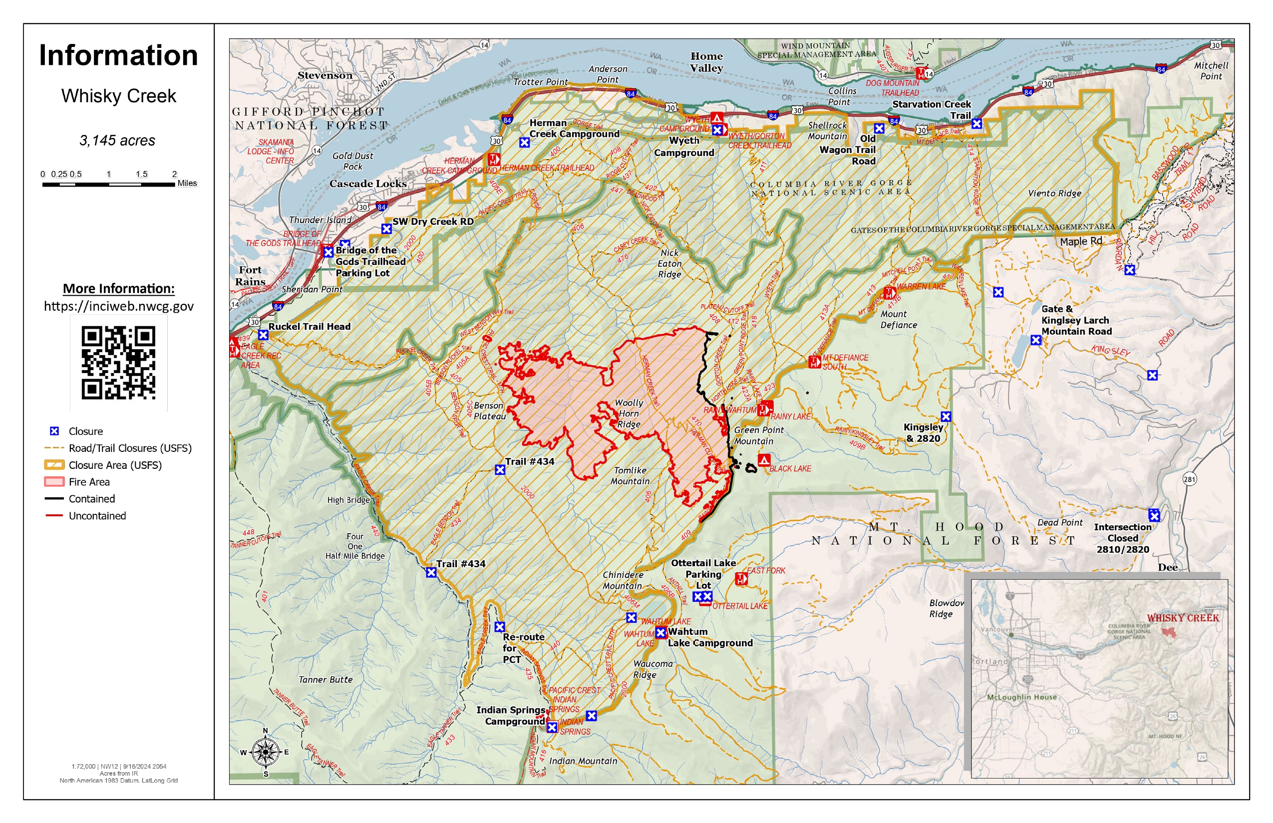
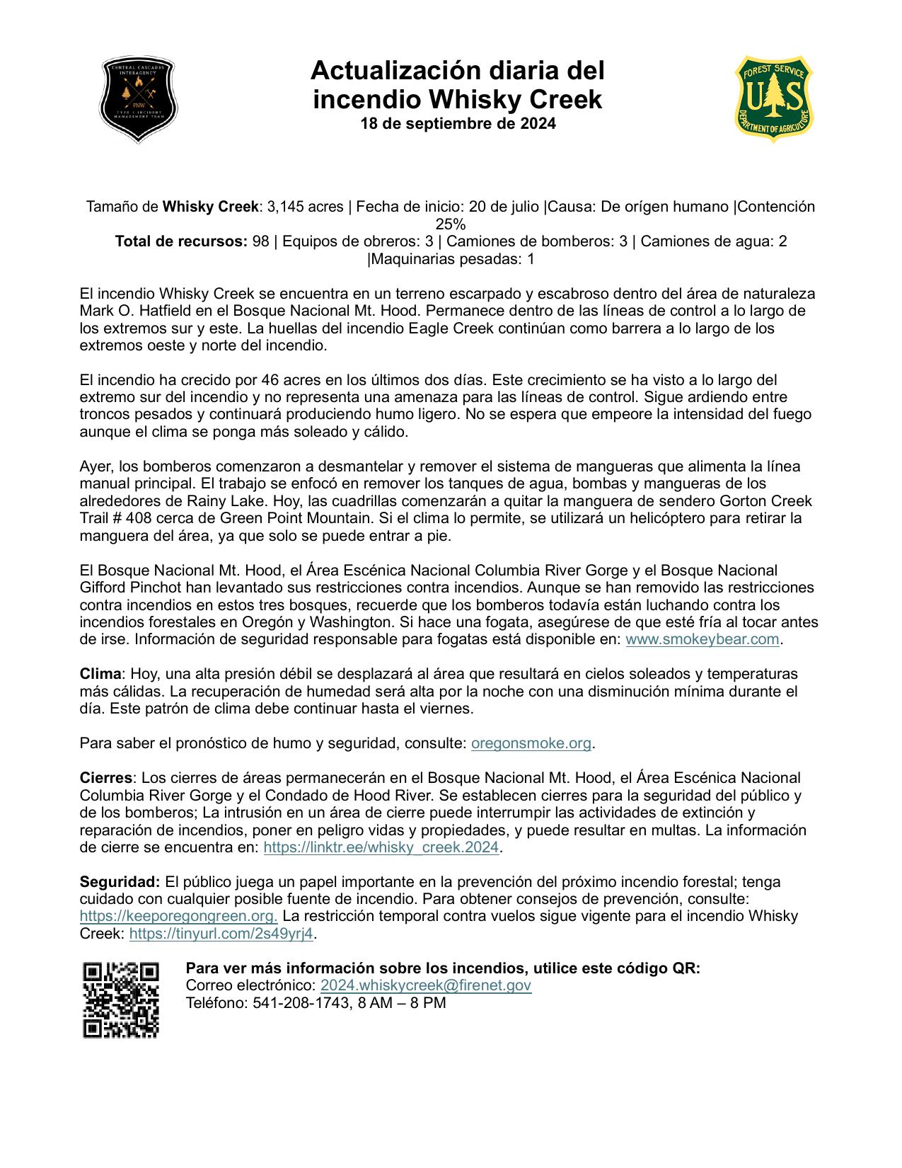
Actualizacin diaria del incendio Whisky Creek 09 18 2024
Related Incident: Whisky Creek Fire
Publication Type: News
Tamaño de Whisky Creek: 3,145 acres | Fecha de inicio: 20 de julio |Causa: De orígen humano |Contención 25%
Total de recursos: 98 | Equipos de obreros: 3 | Camiones de bomberos: 3 | Camiones de agua: 2 |Maquinarias pesadas: 1
El incendio Whisky Creek se encuentra en un terreno escarpado y escabroso dentro del área de naturaleza Mark O. Hatfield en el Bosque Nacional Mt. Hood. Permanece dentro de las líneas de control a lo largo de los extremos sur y este. La huellas del incendio Eagle Creek continúan como barrera a lo largo de los extremos oeste y norte del incendio.
El incendio ha crecido por 46 acres en los últimos dos días. Este crecimiento se ha visto a lo largo del extremo sur del incendio y no representa una amenaza para las líneas de control. Sigue ardiendo entre troncos pesados y continuará produciendo humo ligero. No se espera que empeore la intensidad del fuego aunque el clima se ponga más soleado y cálido.
Ayer, los bomberos comenzaron a desmantelar y remover el sistema de mangueras que alimenta la línea manual principal. El trabajo se enfocó en remover los tanques de agua, bombas y mangueras de los alrededores de Rainy Lake. Hoy, las cuadrillas comenzarán a quitar la manguera de sendero Gorton Creek Trail # 408 cerca de Green Point Mountain. Si el clima lo permite, se utilizará un helicóptero para retirar la manguera del área, ya que solo se puede entrar a pie.
El Bosque Nacional Mt. Hood, el Área Escénica Nacional Columbia River Gorge y el Bosque Nacional Gifford Pinchot han levantado sus restricciones contra incendios. Aunque se han removido las restricciones contra incendios en estos tres bosques, recuerde que los bomberos todavía están luchando contra los incendios forestales en Oregón y Washington. Si hace una fogata, asegúrese de que esté fría al tocar antes de irse. Información de seguridad responsable para fogatas está disponible en: www.smokeybear.com.
Clima: Hoy, una alta presión débil se desplazará al área que resultará en cielos soleados y temperaturas más cálidas. La recuperación de humedad será alta por la noche con una disminución mínima durante el día. Este patrón de clima debe continuar hasta el viernes.
Para saber el pronóstico de humo y seguridad, consulte: oregonsmoke.org.
Cierres: Los cierres de áreas permanecerán en el Bosque Nacional Mt. Hood, el Área Escénica Nacional Columbia River Gorge y el Condado de Hood River. Se establecen cierres para la seguridad del público y de los bomberos; La intrusión en un área de cierre puede interrumpir las actividades de extinción y reparación de incendios, poner en peligro vidas y propiedades, y puede resultar en multas. La información de cierre se encuentra en: https://linktr.ee/whisky_creek.2024.
Seguridad: El público juega un papel importante en la prevención del próximo incendio forestal; tenga cuidado con cualquier posible fuente de incendio. Para obtener consejos de prevención, consulte: https://keeporegongreen.org. La restricción temporal contra vuelos sigue vigente para el incendio Whisky Creek: https://tinyurl.com/2s49yrj4.
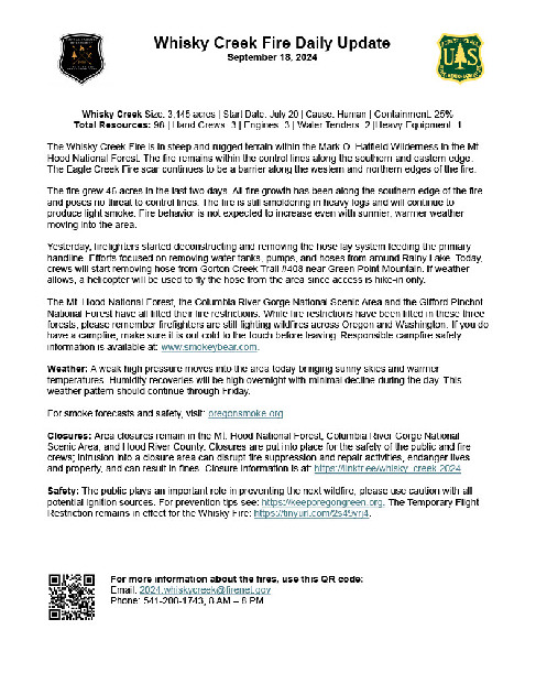
Whisky Creek Fire update 09 18 2024
Related Incident: Whisky Creek Fire
Publication Type: News
Whisky Creek Size: 3,145 acres | Start Date: July 20 | Cause: Human | Containment: 25%
Total Resources: 98 | Hand Crews: 3 | Engines: 3 | Water Tenders: 2 |Heavy Equipment: 1
The Whisky Creek Fire is in steep and rugged terrain within the Mark O. Hatfield Wilderness in the Mt. Hood National Forest. The fire remains within the control lines along the southern and eastern edge. The Eagle Creek Fire scar continues to be a barrier along the western and northern edges of the fire.
The fire grew 46 acres in the last two days. All fire growth has been along the southern edge of the fire and poses no threat to control lines. The fire is still smoldering in heavy logs and will continue to produce light smoke. Fire behavior is not expected to increase even with sunnier, warmer weather moving into the area.
Yesterday, firefighters started deconstructing and removing the hose lay system feeding the primary handline. Efforts focused on removing water tanks, pumps, and hoses from around Rainy Lake. Today, crews will start removing hose from Gorton Creek Trail #408 near Green Point Mountain. If weather allows, a helicopter will be used to fly the hose from the area since access is hike-in only.
The Mt. Hood National Forest, the Columbia River Gorge National Scenic Area and the Gifford Pinchot National Forest have all lifted their fire restrictions. While fire restrictions have been lifted in these three forests, please remember firefighters are still fighting wildfires across Oregon and Washington. If you do have a campfire, make sure it is out cold to the touch before leaving. Responsible campfire safety information is available at: www.smokeybear.com.
Weather: A weak high pressure moves into the area today bringing sunny skies and warmer temperatures. Humidity recoveries will be high overnight with minimal decline during the day. This weather pattern should continue through Friday.
For smoke forecasts and safety, visit: oregonsmoke.org.
Closures: Area closures remain in the Mt. Hood National Forest, Columbia River Gorge National Scenic Area, and Hood River County. Closures are put into place for the safety of the public and fire crews; intrusion into a closure area can disrupt fire suppression and repair activities, endanger lives and property, and can result in fines. Closure information is at: https://linktr.ee/whisky_creek.2024.
Safety: The public plays an important role in preventing the next wildfire; please use caution with all potential ignition sources. For prevention tips see: https://keeporegongreen.org. The Temporary Flight Restriction remains in effect for the Whisky Fire: https://tinyurl.com/2s49yrj4.