
Incident Publication
Willamette Complex South Daily Update for Wednesday September 18 2024 09 18 2024
Related Incident: Willamette Complex Fires - South
Publication Type: News
Willamette Complex South & Red Fire Update
Red, 208, Moss Mountain, Coffee Pot, Tire Mountain, McKinley Creek and Chalk Fires
Date: Wednesday, September 18, 2024
Fire Causes: Lightning
Email: 2024.willamettecomplex@firenet.gov
Information Phone Line: 541-208-1742
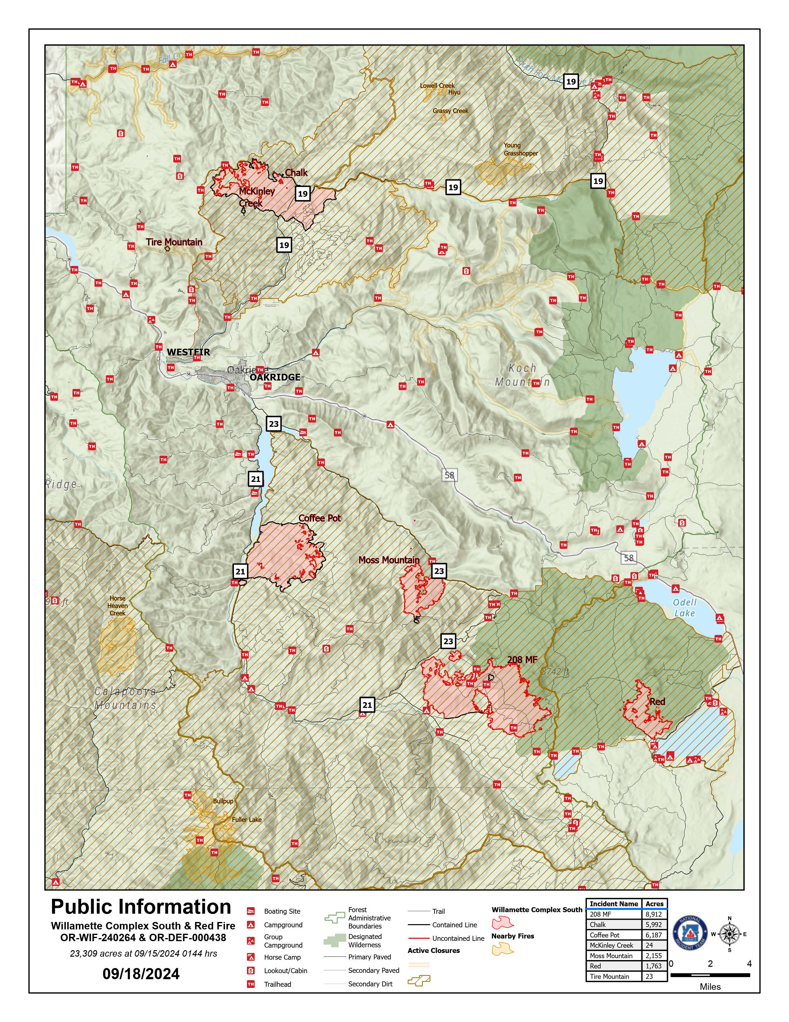
Willamette Complex South: Total Personnel: 441 | Total Willamette Complex South Acres: 23,309
InciWeb: https://inciweb.wildfire.gov/incident-information/orwif-willamette-complex-fires-south
Facebook: https://www.facebook.com/WillametteComplexFires/
Red Fire: Total Personnel: 24 | Total Red Fire Acres: 1,763
InciWeb: https://inciweb.wildfire.gov/incident-information/ordef-red-fire
Facebook: https://www.facebook.com/2024RedFireOR/
Summary
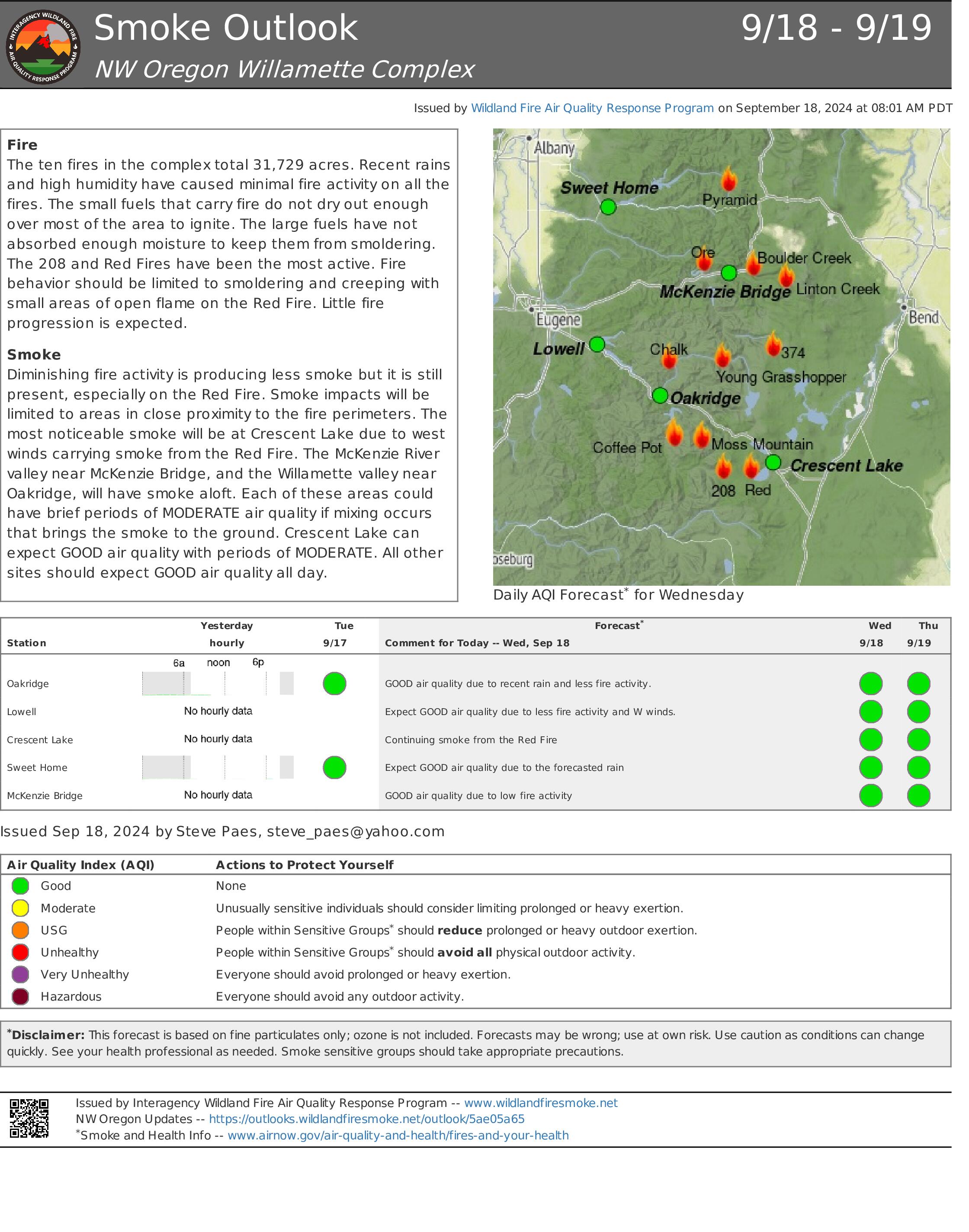
Fire activity across the area remains minimal, with most fires exhibiting only creeping and smoldering behavior. In sun-exposed areas, occasional small open flames may still be visible. Crews are focusing on strengthening indirect firelines and repairing resources affected during suppression operations.
For fires not yet fully contained, any growth is occurring within their existing perimeters. Firefighters are reinforcing indirect firelines to protect communities and values at risk. The fires will continue to smolder and creep until a significant rainfall occurs.
The Chalk Fire, Coffee Pot Fire, McKinley Creek Fire, and Tire Mountain Fire are all 100% contained and have entered the patrol and repair phases. Crews are clearing debris from culverts to maintain proper water drainage and prevent erosion, repairing damaged roads that were used for fire access or impacted by fire suppression activities, and managing materials removed during fireline construction. Crews will continue to prioritize these tasks in coordination with resource specialists such as ecologists, hydrologists, and archeologists. Their expertise ensures that repairs and restoration efforts are scientifically sound and effective.
Red Fire (1,763 acres, 0% containment)
Hauling and removing slash from Forest Service Road (FSR) along 6010 from Summit Lake to southwestern corner of Crescent Lake remains a priority. Firefighters continue road repairs and cleaning the shaded fuel break from Whitefish Horse Camp up to Crescent Lake Sno-Park. Structure protection measures, including portable tanks, hoses, and pumps, will remain in place as fire conditions continue to improve.
208 Fire (8,912 acres, 4% containment)
Firefighters are actively improving holding features between Lighthouse Rock to Summit Lake to minimize acres burned. Material chipping will continue today along FSR 21 from Campers Flat to Emigrant Butte.
Moss Mountain Fire (2,155 acres, 10% containment)
The removal of excess slash and vegetation to strengthen primary lines northeast of Groundhog Mountain is nearly complete. Crews are making progress south of Beach Mountain near FSR 2316 and plan to connect to the existing fireline along FSR 23 from the 208 Fire.
Weather and Fire Behavior
Yesterday, a low-pressure system brought steady rain to the area, which continued through the night and reduced fire activity. Smoldering and creeping fires are now less common as heavy fuels burn out and high relative humidity slows spread. The cooler, more humid conditions will be ending with a gradual warming and drying trend expected for the second half of the week. Temperatures will return to seasonal averages, with lows in the 40s and highs in the 60s. Expect light northwest winds and relative humidity to decrease to around 40 percent.
Closures, Fire Restrictions, and Evacuations
- For closure information, visit: https://tinyurl.com/RedFireClosues2024 & https://tinyurl.com/WillFireClosures2024.
- For fire restrictions, visit: https://tinyurl.com/DesFireRestrictions2024 & https://tinyurl.com/WillFireRestrictions2024.
- The Level 1 – BE READY to Evacuate notice remains in effect for the Red Fire. For more information or to sign up for alerts, visit: www.klamathcounty.org/300/emergency-management.
Homestead Complex and Lane 1 Fire Daily Update 09 18 2024
Related Incident: Lane 1 Fire
Publication Type: News
Email: 2024.homesteadcomplex@firenet.gov
Fire Information Line: 541-208-7100 (Staffed 8 a.m. to 8 p.m.)
Facebook: https://t.ly/mSLvP
Inciweb: https://t.ly/syeHa
September 18, 2024
Firefighters are working to fully suppress eight fires, totaling approximately 35,650 acres, using direct and indirect tactics to respond to all fires. 800 people are assigned to the Homestead Complex and Lane 1 fires. Three of the fires in the Homestead Complex are 100% contained: the Salmon 33 Fire (275 acres) on August 24; the Reynolds Butte Fire (334 acres) on August 22; and the Lost Bucket Fire (34 acres) on July 29.
Crews are improving containment lines across the fire area by reducing fuels through mastication, chipping wood, and hauling fuel to landings away from the fire. There are still many miles of uncontained fire edge. Firefighters are mopping up, widening and strengthening fire lines by extinguishing hot spots and removing fuels. Crews are also clearing and repairing roads impacted by the fires and by fire suppression activities.
On the Horse Heaven Fire (2,741 acres, 56% containment), crews completed preparation of the O25 and O26 roads and will begin mastication along the 3829 road on the uncontained fire edge. They removed hose lays that were no longer needed on the northern half of the hand line at the northwest edge of the fire. Spot fires over the fire line at the northeast fire edge are now in patrol status. On the north and east flanks, firefighters are mopping up 100- to 200-feet in. There is persistent heat in those areas and a lot of ground to cover. Chippers are working on the 3831 road and graders are repairing portions of the 38 road.
On the Fuller Lake (3,690 acres, 0% containment) and Bullpup (535 acres, 7% containment) fires, a chipper and excavator are working along the north flank reducing fuels and cleaning out ditches. The slop-over at the northeast edge of the fire is now secure. On the east flank, mastication is complete; fallers will remove snags to ensure continued access. Approximately ½-mile per day of mastication is underway along the 3810 road adjacent to the wilderness boundary. On the west flank, heavy equipment is working south, masticating fuels and repairing roads, and dozer and hand lines. Hot spots remain in the west, near Bradley Lake.
On the No Man Fire (2,090 acres, 44% containment), there were no major hot spots on the uncontained south edge yesterday. Crews on the south flank finished repairing dozer line near Chilcoot Mountain and will continue to work on other dozer lines in the area today. Today, they will grade roads and patrol the east flank.
Lane 1 (25,951 acres, 99% containment) firefighters are working toward the interior on the west flank along Sharps Creek and Clark Creek roads. Crews finished hauling logs on the 2328 road yesterday. An excavator will continue working along that road today. Crews are also grading to repair the Tye Road, as well as roads on the south flank of the fire. Grading is now complete on the 2362 road. On the east flank, fire managers added a crew to assist with chipping. The focus today is on the southeast flank, removing logs and debris.
Closures and fire restrictions: Two closure orders impact every District of the Umpqua National Forest https://t.ly/Mvn6G. The forest is in High Fire Danger with Public Use Restrictions at Level 2 https://t.ly/LI4cd. A Bureau of Land Management (BLM) Roseburg District closure order is in effect for portions of BLM land bordering the Umpqua National Forest closure north of Steamboat https://t.ly/uWX6l. A BLM Northwest Oregon District closure is also in place for an area west of the Lane 1 fire https://t.ly/oW1lG.
Weather: Approximately 0.1-inch of rain fell across the fire area yesterday. Today, expect humidity and low clouds in the morning, becoming partly cloudy in the afternoon. A warming and drying trend is forecast with temperatures in the 70s on Sunday. With the weather shift, fire may continue to spread in unsecured areas.
Rail Ridge Fire Update September 18 2024 09 18 2024
Related Incident:
Publication Type: News
Rail Ridge QuickFacts
Detection Date: Sept 2, 2024
Cause: Lightning
Acres: 162,345
Containment: 38%
Crews: 35
Engines: 74
Dozers: 19
Helicopters: 2 Type 1, 1 Type 2, 1 Type 3
Total resources: 1,269
Phone: 541-208-7111
Email: 2024.railridge@firenet.gov
Facebook: Rail Ridge Fire - Oregon 2024
LinkTree: https://linktr.ee/RailRidgeFire
Closures and Evacuations
Closures: The U.S. Forest Service and Bureau of Land Management have implemented partial closures because of the Rail Ridge and Crazy Creek fires, for all uses. For more details and closure maps, visit the Ochoco National Forest, Malheur National Forest, and BLM web pages.
Evacuations: Evacuations north of U.S. 26 in Grant County were lifted and the shelter in John Day has been closed. For up-to-date evacuation information, please visit:
- Grant County: Emergency Management Facebook page.
- Crook County: Emergency Management website; Sheriff’s Office Facebook page.
- Wheeler County: Sheriff’s Office Facebook page.
Operational Update
Cooler evening temperatures and higher humidities have continued to slow wildfire activity in the area. Favorable conditions will allow for continued aggressive attack, as well as the strengthening of containment lines around the perimeter.
Hotshot crews will work the northern edge of the Rail Ridge Fire cold trailing for any heat sources and building containment line directly along the fire’s edge where safe to do so. Firefighters will focus efforts around the Battle Creek Mountain area and McNulty Basin as well as around Aldrich Lookout and Chrome Ridge to the east.
The rest of the fire perimeter will be patrolled and crews will mop up any heat sources that could pose a threat to containment while also working on suppression repair.
The fire is expected to exhibit minimal activity today but heavy fuels – dead and downed logs and large stumps – are still holding significant heat.
Tonight will be the last overnight shift for the Rail Ridge Fire.
Weather
Seasonably warm and dry weather is expected for the rest of the week; however, it is not expected to significantly increase any fire activity. Overnight humidity will near 100% with daytime values dropping into the 30% range. Winds will be light and terrain driven with gusts up to 15 mph at elevation.
Bridge Fire Morning Update 09 18 2024
Related Incident: Bridge Fire
Publication Type: News
Unified Command: CIIMT5, Los Angeles County Fire, Los Angeles County Sheriff, San Bernardino County Fire, San Bernardino County Sheriff, CAL FIRE – San Bernardino/Inyo/Mono Unit
Start Date: September 8, 2024, at 2:12 p.m.
Fire Information: (626) 662-0120 ***Original number***
Media Line: (626) 470-1395
Hours: 7:00 a.m. to 9:00 p.m.
Email: 2024.Bridge@firenet.gov
Fire Size: 54,795 acres
Percent Contained: 37%
Personnel: 2,622
Injuries: 4
Structures Damaged: 18
Structures Destroyed: 73
Cause: Under investigation
Location: Sheep Mountain Wilderness, San Gabriel Mountains National Monument
CURRENT SITUATION: Conditions were calm last night as firefighters continued their diligent work in strengthening containment lines and validating their progress. Helicopters were not needed overnight; however, they will focus on water and retardant drops in the highest priority areas in the northwest and southeast flanks.
The highest priority remains on the northwest flank, where steep terrain and heavy fuels still pose a challenge. Firefighters are going direct wherever possible and preventing the rollout of burning vegetation to halt further spread toward Mile High and Paradise Springs communities. Falling modules and other firefighting personnel remain in the area and throughout Big Pines, monitoring, mopping up, and mitigating hazard trees. They expect to add additional containment line percentage here in the coming days.
On the north flank, firefighters successfully conducted nighttime tactical firing operations to protect the Angeles National Forest’s recreation infrastructure in the Table Mountain area, which happens to be within a “Wildfire Crisis Strategy” landscape. Here, Angeles National Forest Fire Management conducted strategic fuel reduction treatments from 2022 through this year, utilizing mechanical thinning, chipping, and mastication, and prescribed fire that created “shaded fuel breaks.” This set the stage for protecting Forest infrastructure in the event of an unplanned wildfire and helped improve the health and resilience of this Jeffrey Pine forest.
On the northeast flank, crews continue constructing direct and indirect containment lines south of Wright Mountain to prevent the fire from spreading toward the community of Lytle Creek.
Air resources will be focused on dropping retardant on the southeast corner to aid firefighters in preventing the fire from spreading to the foothill communities below. This area is also a top priority for firefighters in gaining containment.
On the west flank, crews will work from the East Fork along containment lines, validating that no heat remains and that lines are holding to increase the containment percentage. Three hotshot crews were inserted by helicopter on ridgelines to construct an indirect line within the rugged terrain of the Sheep Mountain Wilderness.
Damage inspection teams continue to update interactive maps for residents affected by the Bridge Fire.
For San Bernardino County: prepare.sbcounty.gov/bridge-fire/
For Los Angeles County: recovery.lacounty.gov/bridgefire/
Evacuation Orders:
- The area above the Mt. Baldy Ski Resort
- Big Pines Canyon Road to the community of Big Pines
- East Fork communities of Camp Williams Resort and River Community
Evacuation Warnings:
- Mt. Baldy Ski Resort area from Ice House Canyon Trailhead, north to the Mt. Baldy Ski Resort
- From San Antonio Canyon East to Telegraph Peak
- Community of Wrightwood
- Shin Road north to Icehouse Canyon is open to residents only
For interactive maps on evacuations:
- Los Angeles County: Genasys Protect website or download the app. https://protect.genasys.com
- San Bernadino: https://sbcounty.maps.arcgis.com
For emergency alerts, please register here:
- Los Angeles County: https://ready.lacounty.gov/emergency-notifications/
- San Bernardino County: https://wp.sbcounty.gov/sheriff/alerts/
Evacuation Centers:
- San Bernardino County Fairgrounds: 14800 Seventh Street, Victorville, CA
- Pomona Fairplex: 601 W McKinley Avenue Pomona, CA (Gate 3, corner of McKinley/White)
Animals:
- Devore Animal Shelter: 19777 Shelter Way, San Bernardino, CA. (909) 386-9820. After hours: (800) 472-5609
- San Bernardino County Fairgrounds: 14800 Seventh Street, Victorville, CA
- Palmdale Animal Care Center (Small Animals): 38550 Sierra Hwy, Palmdale, CA
- Lancaster Animal Care Center (Small Animals): 5210 W Ave I, Lancaster, CA
For more information on evacuation centers:
- www.redcross.org/get-help/disaster-relief-and-recovery-services/find-an-open-shelter.html
- https://lacounty.gov/emergency/
ROAD CLOSURES:
- Big Pines Highway * Big Rock Creek Road *Largo Vista Road
- Mescal Creek Road
- Panorama Motorway
- SR-39 at the Base of San Gabriel Canyon
- Glendora Mountain Rd. north of Big Dalton Rd.
- Mt. Baldy Rd at Shinn Rd (open to residents only)
- Mt. Baldy at Ice House Canyon Rd.
- SR-2 at Flume Canyon Rd westbound
WEATHER:
Humidity recovery improved last night, and more moderate weather is expected to persist today in both in temperature and favorable winds for firefighters. Colder and wetter conditions are expected tomorrow, but on Friday a warming and drying trend will return, but with offshore winds.
Bachelor Complex Flat Top and Firestone Fires Update 09 18 2024
Related Incident: Bachelor Complex FiresFlat Top and Firestone Fires
Publication Type: News
Northwest 3 Complex Incident Management Team
Lonnie Click ~ Incident Commander
September 18, 2024
Bachelor Complex, Flat Top and Firestone Fires Update
September 18, 2024
Quick Facts: Bachelor Complex
Size: 10,958 acres
Start Date: Sept 8, 2024
Location: 20 miles SW Bend, OR
Personnel: 529
Containment: 29%
Quick Facts: Firestone & Flat Top Fires
Firestone Size: 9,195 acres
Start Date: Sept 6, 2024
Location: North of Fort Rock, OR
Containment: 60%
Flat Top Size: 35,456 acres
Personnel: 294
Containment: 43%
All evacuation levels throughout the Bachelor Complex, Firestone and Flat Top fires in Deschutes and Lake Counties have been lifted. Deschutes National Forest emergency closures remain in effect. Moderated temperatures continued to help firefighters complete successful fire suppression tactics throughout the area. Yesterday, dozer line construction continued for the Bachelor Complex on the northeastern and western edges of the Little Lava Fire. On the Firestone Fire, crews used strategic burning operations to remove receptive fuels ahead of the fire to secure control lines south of Forest Service Road (FSR) 2310. Suppression repair work also progressed on the western flank of the fire’s perimeter. On the Flat Top Fire, hazard tree removal along FSR 22 was completed. Dozer lines have also been constructed to contain and stop any spread on the northern flank of the fire.
Bachelor Complex: Today on the Little Lava Fire, firefighters continue to prepare a road system east of Siah Butte for a burn out operation planned for Friday or Saturday depending on favorable conditions to secure the southern side of the fire. Mop-up, patrol and suppression repair efforts will continue along the northeast end of the fire.
Thanks to an increase in firefighting resources and favorable weather conditions, firefighters have successfully established control lines along the western, southern and eastern perimeters of the Little Lava Fire. This progress has reduced the threat of the fire spreading in these directions. The northern perimeter of the Little Lava Fire, however, encompasses steep and remote rocky terrain. Indirect control lines have been identified as a precautionary measure to contain this area if needed. Due to recent rain and cooler temperatures, it is unlikely that the fire will reach these control lines. Nevertheless, this area will remain a focus for firefighters as they closely monitor weather conditions using aerial patrols and advanced predictive modeling to assess whether these lines will be necessary. While minimal fire growth is anticipated on the northern perimeter under these conditions, firefighters will remain vigilant and prepared to implement the indirect control lines if any changes in weather or fire behavior occur.
Flat Top Fire: Today, firefighters are preparing dozer line north of FSR 18 for strategic burning operations which may occur today or tomorrow depending on weather conditions. Suppression repair, mop-up, patrol and hazard tree removal will continue along the southern, western and northern flanks of the fire.
Firestone Fire: If conditions are favorable, firefighters will continue burning operations today on the eastern edge of the fire along FSR 100 to connect and secure control lines. On the western flank, crews will continue to mop-up and patrol to ensure the fire remains within established control lines.
Weather and Fire Behavior: Fire behavior is expected to increase today. Pockets of unburned fuel within the fire perimeters will continue to burn and produce smoke. A warming and drying trend is moving into the area and will continue into Thursday. Highs are expected to reach the mid 60’s to around 70 degrees, with relative humidity around 30-35%. Light winds out of the east, southeast are expected today.
Closures: There are two emergency closure areas on the Deschutes National Forest for these fires. To view the updated closure orders and maps, visit: https://www.fs.usda.gov/alerts/deschutes/alerts-notices.
Facebook: https://www.facebook.com/deschutesnationalforest/
InciWeb:
https://inciweb.wildfire.gov/incident-information/ordef-bachelor-complex-fires
https://inciweb.wildfire.gov/incident-information/ordef-flat-top-and-firestone-fires
YouTube: https://www.youtube.com/@CentralOregonFireInfo?app=desktop
Fire Information Line: (541) 249-9829, 8:00 a.m. to 8:00 p.m.
Smoke & Air Quality Information: fire.airnow.gov
Fossil Complex Daily Update 09 18 2024
Related Incident: Fossil Complex
Publication Type: News
Expect Smoke Inside the Fire Lines of Service Fire
SPRAY, Ore. – Yesterday afternoon, as temperatures increased and humidities decreased, unburned fuels on the interior of the Service Fire sent up a few plumes of smoke. Over the coming days expect to see some remaining pockets of fuels burn within the fire’s interior. Aerial and ground resources are ready to respond to any ignitions that may threaten containment.
The Oregon Department of Forestry Incident Management Team 3 (ODF IMT 3) will arrive at the Fossil Incident Command Post this afternoon for an inbrief. Following Inbriefing, the incoming team will shadow ODF IMT 2 to allow for a smooth transfer of command tomorrow morning at 6 am.
Prior to arrival both ODF teams have been coordinating and sharing information for a seamless handoff. Matt Howard, Incident Commander of the Oregon Department of Forestry Team 2 told his team, “Let’s give them a package that lets them get to work on day 1. It doesn’t matter which team is here, we all fight fire as ODF, so let’s give them a plan and resources to get it done.”
It will be mostly sunny today with temperatures ranging from 66-71 degrees and humidities from 37-42%. Southwest winds around 6 mph shifting to West-Northwest 6 mph and gusting to 13 mph.
Yesterday afternoon, through a joint decision, all evacuation levels for the Service Fire were lifted and all zones have been placed into "Normal" status.
Videos: Recordings of the Daily Operations Updates and other stories are available at: https://www.youtube.com/@FossilComplex.
The Two Cabin, Holmes, Kinzua and Canyon Fires are all in patrol status.
FIRE AT A GLANCE
Fossil Complex
Total Size: 24,446 acres
Two Cabin-253 acres
Canyon-192 acres
Kinzua-96 acres
Holmes-15 acres
Service- 23,890
Containment: 47%
Cause: Lightning
Current Cost: $22.1M
All Resources
Hand Crews: 38
Engines: 51
Water Tender: 17
Dozers: 11
Skidgen: 5
Excavator: 2
Masticator: 1
Total Resources: 1,166
Aerial Resources
Type 1: 2
Type 2: 3
Type 3: 3
UAS 3: 1
Evacuations:
None
ODF Incident Commander:
Matt Howard
Incident Management Team 2
Devils Knob Daily Update 09 18 2024
Related Incident:
Publication Type: News
Devil’s Knob Fire Update for Wednesday, September 18, 2024
KEY MESSAGES:
The Devil’s Knob Fire’s total acreage remains unchanged. Containment did not increase yesterday but is expected to increase today as mop-up operations continue. All tethering operations on the south flank of the fire are complete. These tactics reduced risk to firefighters by mitigating the amount of time 20-person crews operate in steep, hazardous terrain. The 1610 Road has been completely graded.
CURRENT STATUS:
Resources: 632; Crews: 19; Engines: 10; Dozers: 4; Water Tenders: 8
Aircraft: One Type 1 helicopter, one Type 3 helicopter, one unmanned aerial system
The western flank of the fire is fully contained, and resources are being distributed to other divisions to bolster containment efforts. Personnel will continue to patrol the western and northern edges of the fire as crews repair roads following suppression actions. Tree fellers will reduce danger trees and fuels that could carry fire over dozer line.
The goal today is to complete suppression actions in the Flat Creek drainage and continue containment efforts on the eastern flank of the fire near the 1610 Road. This area of the perimeter will require further gridding for mop-up as the spot fires from last week created a complex burn pattern, leaving pockets of unburned vegetation that could reignite in hot, windy conditions.
WEATHER / FIRE BEHAVIOR:
Relative humidity in the fire area remains extremely high, naturally decreasing fire activity. The chance of precipitation will reach 80% through Wednesday morning with less than a quarter inch of rain expected. The rest of the week will be dry with warmer temperatures in the mid-60s to low 70s and light winds in the forecast. Dry, heavy fuels still exist within the fire perimeter, and crews will be working to identify these areas to prevent fire activity increasing as conditions dry.
SAFETY AND CLOSURES:
Closures on the Umpqua National Forest can be found at https://www.fs.usda.gov/alerts/umpqua/alerts-notices.
Umpqua National Forest restrictions can be found at https://www.fs.usda.gov/main/umpqua/fire.
Fire Restrictions for Bureau of Land Management can be found on the Oregon-Washington blm.gov page.
Douglas Forest Protective Association restrictions can be found at https://www.dfpa.net/public-fire-restrictions.
Oregon Dept. of Forestry restrictions can be found at https://www.oregon.gov/odf/fire/pages/restrictions.aspx.
Line Fire Daily Status Update 09 18 2024
Related Incident: Line Fire
Publication Type: News
Cooler temperatures over the Line Fire are bringing up moisture levels in the vegetation. There was minimal fire growth overnight. It was mostly clear with brisk temperatures over the fire area. Partly cloudy conditions are expected to develop throughout Wednesday. Firefighters are strengthening control lines and mopping up hot spots.
There have been multiple drone incursions over the Line Fire area. This impedes our firefighting operations and can have deadly consequences. Please be respectful of those fighting the fire and the community members who are impacted by fire. Never fly drones near wildfire. If you fly, we can't.
Pearl Fire Daily Update 09 18 2024
Related Incident:
Publication Type: Announcement
FORT COLLINS, Colo. (Sept. 18, 2024) – Yesterday's weather tested the fire perimeter with gusty winds, but there was no growth in fire size. Pearl Fire remains estimated at 128 acres with 5% containment.
Air resources continued to work the fire throughout the day yesterday until conditions became unsafe due to high winds. Roughly 260 ground personnel and multiple air resources are on scene today. Ground crews will focus efforts on structure protection along the eastern perimeter and use heavy equipment to secure the fire line. Crews will face steep terrain and downed trees as they work to contain the fire. Lower humidity levels, high winds and warmer temperatures are expected to throughout the day. In the afternoon, winds could gust up to 35 mph.
Larimer County Sheriff's Office will continue to operate the Joint Information Center and provide information about evacuation notices, animal evacuations and road closures. For evacuation information visit https://www.nocoalert.org/ or text LCEVAC to 888777. The Joint Information Center can be reached at (970) 980-2500.
The Forest Service remains in Stage 1 fire restrictions. Refer to the Arapaho and Roosevelt National Forests website for more information.
For more information on the Pearl Fire visit InciWeb and for the latest updates, follow us on Facebook and Twitter. To receive email updates on this fire, join our email list and select Forest Health & Fire: North of Hwy 14 to Wyoming Border (Red Feather Lakes).
Wednesday September 18 2024 RailroadDaly Update and Map 09 18 2024
Related Incident:
Publication Type: News
September 18, 2024
The area closures surrounding the fires are still in effect. These closures are necessary to protect the safety and welfare of the public and provide for safe firefighter and equipment operations and access. Fire managers are working in conjunction with Bitterroot National Forest officials to assess the need and potential boundary changes. More information on Bitterroot National Forest area closures can be found at: https://www.fs.usda.gov/alerts/bitterroot/alerts-notices
The fires saw significant precipitation over the last 24 hours and fuels are approaching “moisture of extinction,” meaning larger fuels are saturated to the point they no longer support burning or combustion. Sharrott Creek received 6/10 of an inch of rain, while Johnson got 1/3 of an inch and Daly and Railroad received an inch.
All fires are downsizing in personnel numbers, as firefighters complete suppression repair work and fire activity decreases.
Skalkaho Highway (Highway 38) remains closed from milepost 9.0 to 28.2. Visit Montana DOT for the most updated information: https://www.mdt.mt.gov/
Northern Rockies Complex Incident Management Team 5 will transfer command of all fires back to the Bitterroot National Forest on September 20, 2024 at 6 p.m.
Current Status
Johnson (3 miles south of Springer Memorial Community, in the East Fork)
Cause: Lightning
Size: 6,687
Completion: 59%
Personnel: 50
Firefighters continue to make progress implementing suppression repair efforts using excavators and hand tools to pull back berms on constructed firelines. The excavators are working both the west and north flanks of the fire.
Sharrott (3 miles west of Stevensville)
Cause: Lightning
Size: 3,204
Completion: 83%
Personnel: 228
Firefighters are expected to complete suppression repair efforts on handlines on Wednesday, while excavators will continue to pull back berms on constructed firelines on the northern and southern firelines. Excavators are working downhill and are on schedule to complete repair work within a week.
Daly and Railroad (Railroad and Skalkaho Creeks confluence, 26 miles southeast of Hamilton)
Cause: Undetermined
Size: 6,813 (Daly), 1,007 (Railroad)
Completion: 59% (Daly), 35% (Railroad)
Personnel: 21
Minimal fire activity is present, with no expected spread on the Railroad and Daly Fires. Crews will continue with hazard mitigation along the Skalkaho Highway (Highway 38), Forest Service Road 711, and associated spur roads.
Weather and Fire Behavior
High temperatures on Wednesday will be in the mid 60s in the valley and mid 50s across the higher elevations. Isolated showers will continue throughout the morning and dissipate in the afternoon. Skies will remain overcast over the course of the day, and winds will subside mid-day.
Fire behavior will be isolated smoldering, primarily in stump holes.