
Incident Publication
Fish Creek Fire Update Wednesday 09 18 2024
Related Incident:
Publication Type: News
Northern Rockies Team 2, Incident Commander Scott Schuster
Location: 7 miles SW of Togwotee Pass
Start Date: Friday, August 16, 2024
Cause: Lightning
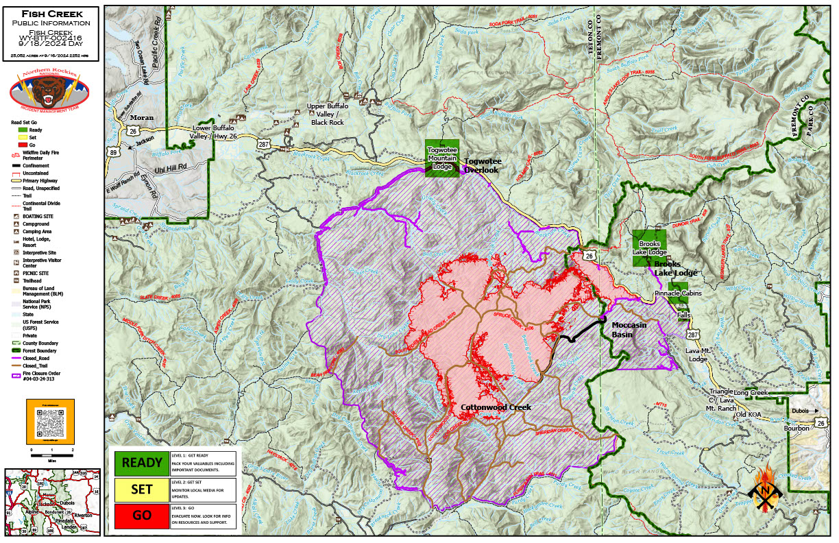
Size: 25,017 acres
Percent complete: 79%
Resources: 354 Total Personnel: 9 Hand Crews; 7 Engines; 12 Heavy Equipment; 2 Helicopter
KEY MESSAGES:
Even with moisture and light snow, the fire continues to smolder in heavy timber, litter, dead and down timber, and younger mixed conifers. Minimal fire behavior is expected, but creeping, smoldering, and backing behavior of the fire will continue with an occasional single tree torching.
Firefighters and heavy equipment will continue to work in the Highway 26/287 corridor. Please drive with caution, especially with snowy conditions over the pass. Public and firefighter safety continues to be our highest priority on the Fish Creek Fire.
The Bridger-Teton and Shoshone National Forests updated the Closure Order for the area of the fire on Sept. 17th, opening the areas north of US-26 that had been previously closed. The closures that remain provide for public and firefighters safety. Please respect the orders for roads, campgrounds, and trails that remain closed. Additional information regarding the current closure order can be found on the Forest websites. Numerous hazards will remain in those areas.
CURRENT STATUS:
Due to inclement weather yesterday which impacted roads in the fire area, firefighters disengaged on more remote parts of the fire for safety reasons and to minimize impact to roads. Hand crews, however, continued repairing some of the disturbance caused by suppression efforts along Deception Road from Highway 26 to Brooks Lake Lodge campground. Firefighters will continue to monitor fire behavior in the area for potential threats to the HWY 26 and other critical values.
Firefighters continued to make progress on the fuels mitigation project around the structures of Togwotee Lodge. The cutting phase is complete and now removal of vegetation debris will proceed as well as brush reduction. This action will improve defensible space for values at risk from future wildfires. Large amounts of vegetation have been mitigated from this area.
WEATHER AND FIRE BEHAVIOR:
The area of the Fish Creek Fire has received a significant amount of moisture across the fire zone over the last week. Forecast is for scattered rain today, continued through the evening. This precipitation will further reduce fire activity.
AIR QUALITY AND SMOKE:
Aside from continued smoldering and isolated torching, the fire footprint is putting up minimal smoke. For up-to-date air quality alerts, current and predicted smoke conditions and ways to mitigate poor air quality, check out the AirNow website at https://www.airnow.gov/.
CLOSURES AND EVACUATIONS:
The joint Closure Order issued by both the Bridger-Teton and Shoshone National Forests for the fire area, remains in effect. Please do not enter the closure area or use any Forest Roads that are closed. For specific details regarding this closure, please reference the announcement on Inciweb for Sept 17th, 2024.
Under the jurisdiction of Fremont County, the areas of Brooks Lake, Pinnacle Drive and Breccia Drive have been reduced to Level 1 “Ready” Status (indicated by green blocks on the PIO Incident Map). A Level 1 “Ready” Status means residents should closely monitor information feeds regarding fire activity. See the Fremont County Fire Protection District Facebook page for current alerts.
The Teton County Division of Emergency Management utilizes a Ready, Set, Go system for evacuation messaging, visit their website for additional details at www.tetoncountywy.gov/1846/Ready-Set-GO. (Indicated by green blocks on the PIO Incident Map.) They advise all residents to be in a “Ready” status by preparing for evacuations and becoming fire adapted. All residents are encouraged to sign up for Teton County, Wyoming's free alert and warning service, Teton WY Alerts at: Teton_WY Alerts - Sign Up (everbridge.net).
US HWY 26/287 is open for free-flowing traffic. Motorists may still experience smoke and sometimes limited visibility as well as wintery road conditions. A 45-mph speed restriction remains in effect for the fire area. Motorists are encouraged to stay alert for fire personnel and fire vehicles and use caution when travelling through the area.
The Wyoming Department of Transportation (WYDOT) continues to work closely with Fremont County Emergency Management, Fremont County Sheriff’s Office and fire officials for the safety of motorists and firefighters.
Drivers are encouraged to visit https://www.wyoroad.info/ prior to traveling on US HWY 26/287 for road status and information, or download the Wyoming 511 app at https://www.wyoroad.info/511/WY511Mobile.html to monitor for any changes due to fire activity.
Daily Update for the Frog Fire 09 19 2024
Related Incident: Frog
Publication Type: Announcement
Frog Fire Statistics:
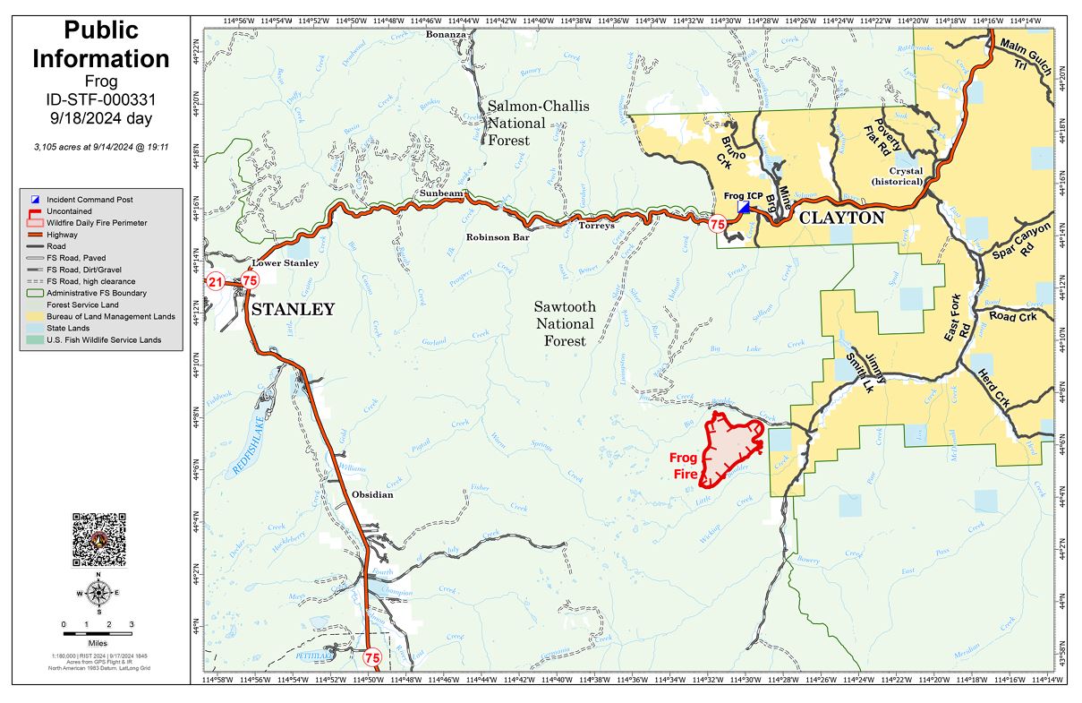
Size: 3,105 acres
Containment: 42%
Total Personnel: 231
Location: Little Boulder Creek off East Fork
Reported: 9/7/2024
Cause: Lightning
For More Information:
Information Phone: 208-510-7856
Email: carlie_swa@firenet.gov
InciWeb: https://inciweb.wildfire.gov/incident-information/idstf-frog Facebook: https://www.facebook.com/sawtoothnationalforest
Yesterday brought intermittent rain followed by steady showers throughout the day, with light winds. Fire activity remained minimal, with smoke only observed in Division Z. Crews successfully completed chipping operations in the Structure North and South groups along the East Fork Road.
Muddy roads and persistent rain prevented crews from entering the fire area. However, an infrared (IR) flight was conducted to survey the fire. A drone using infrared technology was used to detect heat sources and hotspots within the fire area.
Weather permitting, crews will continue with current operations today, including monitoring and prepping the fire’s containment lines.
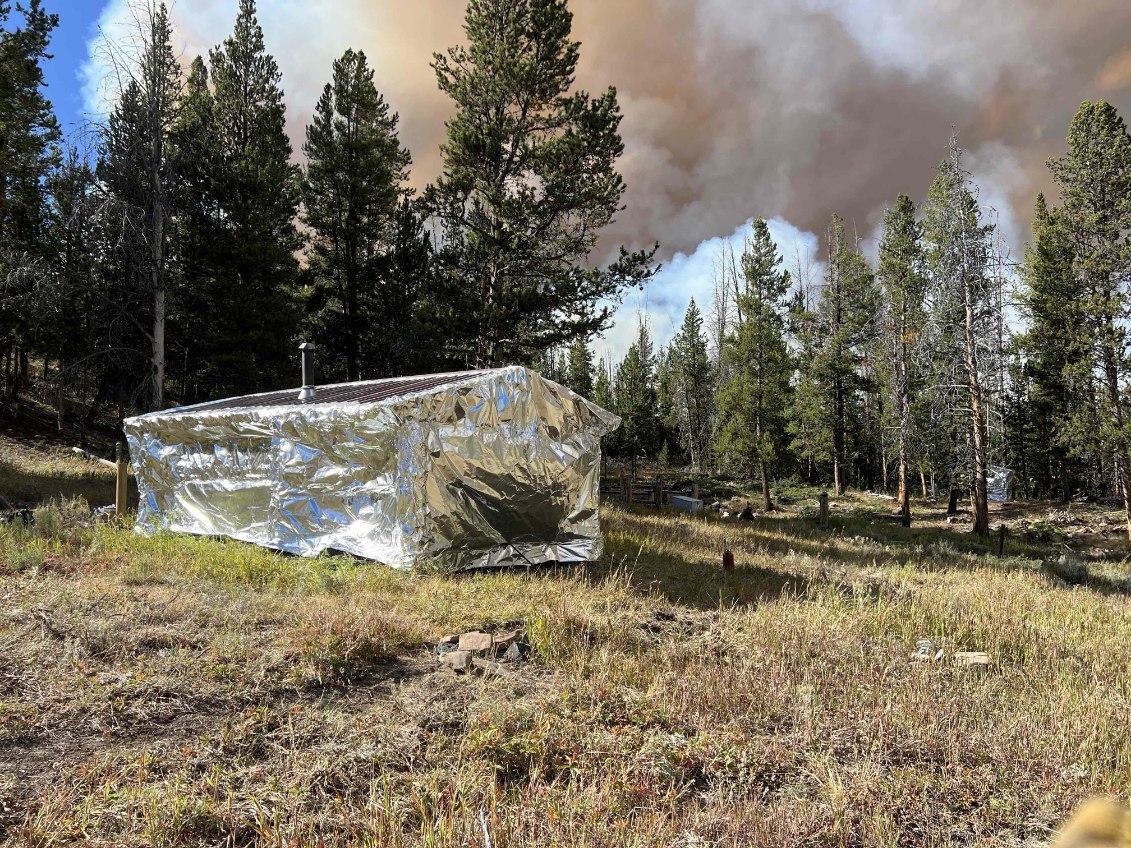
A Wildland Fire Module (WFM) arrived yesterday to support the transition as current resources near the end of their operational shifts. The WFM is a specialized crew that manages and monitors wildfires. Additionally, the Complex Incident Management Team, Great Basin Team 4, has been ordered.
Weather, Fuels, and Fire Behavior:
Partly cloudy skies will give way to mostly cloudy conditions by the afternoon, with a chance of thunderstorms. Stronger storms may bring heavy rainfall and small hail. Gradual drying is expected starting Wednesday and continuing into the weekend. Seasonably cool temperatures will persist through the week, with isolated to scattered precipitation lingering, although drier conditions are expected later in the week.
Evacuations:
For evacuation information on the Frog Fire, please see the Custer County Sheriff’s Facebook page at https://www.facebook.com/p/Custer-County-Sheriff-Idaho-61558947312289/ and the Custer County Emergency Management Facebook page at https://www.facebook.com/ccem.idaho
To sign up for Custer County CodeRED emergency notifications, text CUSTER to 99411 or enroll online at https://public.coderedweb.com/CNE/BF28E45537FF .
Closures and Fire Restrictions:
The Frog Fire Area Closure /Forest Order: 0414-04-152 for portions of the Sawtooth National Forest can be found at this site: https://inciweb.wildfire.gov/incident-publication/idstf-frog/frog-fire-closure-09-10-2024
Fire restrictions on federal, state, and private lands may be found at this site: https://www.idl.idaho.gov/fire-management/fire-restrictions-finder/.
Wildfires are a no-fly zone for unauthorized aircraft, including drones. If you fly, we can’t. For more information, visit http://knowbeforeyoufly.org.
####
Wapiti Fire Information Update 09 18 2024
Related Incident:
Publication Type: News
Wapiti Fire Statistics:
- Size: 125,459 acres
- Completion: 71%
- Total Personnel: 689
- Location: Grandjean, ID
- Reported: July 24, 2024
- Cause: Lightning
For more information:
- Information Phone: 208-593-7132
- Email: 2024.wapiti@firenet.gov
- InciWeb: https://inciweb.wildfire.gov/incident-information/idbof-wapiti-fire
- Facebook: https://www.facebook.com/wapitifireinfo2024
- Linktree: https://linktr.ee/WapitiFireInfo2024
- Interactive Map: https://tinyurl.com/WapitiFireInfoMap
Special Notes: Highway 21 remains closed from MM 84 (northeast of Lowman) to MM 126 (Stanley Lake turn off). There is high public interest in reopening the highway. A multi-agency coordination group meets frequently to assess road conditions and will open the road as soon as it is deemed safe for travel. Recent rains pose a threat of debris flows across not only Highway 21 but any roads adjacent to steep burned areas.
Current Situation: As the Incident Management Team continues to downsize the scale of suppression operations, there remains a dedicated force on the Wapiti Fire. One of these downsizing strategies includes the combining of operational divisions. All divisions on the west side will merge under Branch IV and the east side merge under Branch VI.
Operationally, the focus has switched to suppression repair. These repairs are coordinated with the respective Forest Service and Idaho Department of Lands unit and resource advisors to limit lasting impacts from suppression activities. Precipitation on Tuesday fell over all areas of the fire, which will continue to moderate fire behavior and allow crews to focus on repairs.
Branch IV West Side: Along Highway 21 in the communities of Ten Ax, Two Ravens, Lowman Ponds, Sourdough and Lowman proper, the Incident Management Team with input from local officials made the decision to remove structure protection equipment yesterday. Repair work will continue in these communities.
A significant debris flow occurred in the Grandjean area yesterday as a result of intense precipitation. The cleanup and repair associated with this debris flow will be conducted by the Boise National Forest. The road is currently impassable.
On the north side of the branch, containment was added to the perimeter of the fire around the Warm Springs area up to 8-Mile Ridge and along a northwest section of Chapman Creek. Moving to the north, the handline from Highway 21 up to Bulltrout Lake was checked for any hot spots. Managers are confident that this section is contained based on field observations and unmanned aircraft system flights.
Branch VI East Side: On the east side of Cape Horn, Forest Service Road 203 will be fully graded within the next two days. This work is being done to restore the road to its original condition after it was heavily used by firefighters during suppression activities.
To the southeast, crews are continuing to clear hazard trees in the Stanley Lake area using falling modules and heavy equipment. Removing hazard trees is a crucial part of suppression repair, as fire-weakened trees can pose a danger to people moving through a burned area.
Along the Highway 75 corridor, suppression repairs are complete on the handline behind the Stanley Ranger Station.
Weather, Fuels, and Fire Behavior: This morning clouds will remain low in both the Lowman and Stanley areas and lift in the afternoon. Today will be mostly dry with only a slight chance of precipitation over the fire area. Temperatures will return to normal season ranges with highs in the low to mid 60’s. Relative humidities will range from 80-100% with the anticipated continuous cloud cover. Wind speeds will remain stable at 10-15 miles per hour on the ridge tops throughout the day.
The recent rain has increased fuel moisture levels, but heavy fuels are still retaining heat. Despite this, the risk of fire spreading remains low.
Evacuations:
Evacuation status for Stanley Zone 1 has changed from SET to READY. Stanley Zones 2-5 and Kasino are no longer in an evacuation status.
Evacuation status for Boise County on the Loman side of the Wapiti Fire has been downgraded to READY (Level 1) in all zones.
For evacuation information on the Wapiti Fire, please see the Custer County Sheriff’s Facebook page at https://www.facebook.com/p/Custer-County-Sheriff-Idaho-61558947312289/ and the Boise County Sheriff’s Facebook page at https://www.facebook.com/boisecountysheriff/.
To sign up for Custer County CodeRED emergency notifications, text CUSTER to 99411 or enroll online at https://public.coderedweb.com/CNE/BF28E45537FF
To sign up for Boise County Alert Sense emergency notification enroll online at https://public.alertsense.com/SignUp/publicUser.aspx?regionid=1163
Closures and Fire Restrictions:
The Middle Fork Complex Fire Closure Order is amended to provide consistency with the Wapiti Fire closure. This amended order, Forest Order #0402-06-64, closes the 582 and 563 roads, as well as the 579 road from its junction with 563 eastward to the junction with Highway 21. More information can be found at: https://www.fs.usda.gov/alerts/boise/alerts-notices
State Highway 21 remains closed from MP84 (northeast of Lowman) to MP126 (Stanley Lake turn off) for public and firefighter safety.
A Wapiti Fire Area Closure / Forest Order: 0414-04-151 for portions of the Boise, Sawtooth, and Salmon-Challis National Forests can be found at this site: https://www.fs.usda.gov/alerts/sawtooth/alerts-notices
Boise National Forest Stage 1 Fire Restrictions / Forest Order: 0402-00-63 can be found at this site: https://www.fs.usda.gov/alerts/boise/alerts-notices
Sawtooth National Forest Stage 1 Fire Restrictions / Forest Order 0414-00-044 can be found at this site: https://www.fs.usda.gov/alerts/sawtooth/alerts-notices
Fire restrictions on federal, state, and private lands may be found at this site: https://www.idl.idaho.gov/fire-management/fire-restrictions-finder/
A Temporary Flight Restriction (TFR) is in place over the Wapiti Fire. Wildfires are a no-fly zone for unauthorized aircraft, including drones. If you fly, we can’t. For more information, visit http://knowbeforeyoufly.org.
Daily Update for the Chimney Fire 09 18 2024
Related Incident: Chimney Fire
Publication Type: News
Closure area reduced around the Chimney Fire
Daily Update – Wednesday, September 18, 2024
Acres: 6,519
Start Date: 9/2/2024
Location: 9 miles northwest of Fairfield, ID
Personnel: 225
Containment: 48%
Fuels: Timber, brush, grass, understory
Highlights: Containment continues to steadily increase around the southern and eastern sides of the fire. The previous closure area around the fire has been reduced to a smaller area following successful firefighting efforts and significant precipitation over the past few days.
Operations: Yesterday, the entire fire area received an average of a half inch of precipitation. Firefighters observed smoke on the southeast side of the fire, well within the interior of the containment lines. Crews continued to backhaul unneeded equipment from around the fire area to ensure no excess items are left behind in the forest. Medical personnel conducted additional Emergency Medical Technician (EMT) training with firefighters yesterday to help maintain and enhance these critical skills. Fire behavior models used by fire managers to predict future activity levels show that the current fuels on the ground are very unlikely to burn. Given these results, along with recent weather and successful containment operations by firefighters, additional fire spread is not anticipated for the foreseeable future. The Initial Attack group remains ready for any new starts or suppression needs. Suppression repair efforts and supply collection will continue today with the help of heavy equipment.
Weather: Chances for precipitation are minimal today, although cloud cover will linger in the area. Afternoon high temperatures will only warm 1 to 3 degrees and humidity will only lower another 2 to 4 percentage points. Wind will become northwest with gusts near 20 mph this afternoon.
Smoke: Some smoke may be visible from the Fairfield area, however air quality continues to improve. An interactive smoke map located at https://fire.airnow.gov/ allows you to zoom into your area to see the latest conditions.
Closures: The Sawtooth National Forest has issued an updated, smaller emergency temporary closure area for the Chimney Fire. The purpose of the closure order is to protect firefighters and the public during wildfire suppression activities occurring in and around the area. The full closure order (No. 0414-05-065) and map are available on the Sawtooth National Forest website at https://www.fs.usda.gov/alerts/sawtooth/alerts-notices.
Safety: The health and safety of firefighters and the public are always the first priority. A temporary flight restriction (TFR) is in place over the area, which includes uncrewed aircraft or drones. Flying drones near wildfires is dangerous for pilots and firefighters and can bring wildfire suppression efforts to a halt. Know before you fly. If you fly, we can’t. More information can be found at: https://uas.nifc.gov/.
More Information: https://inciweb.wildfire.gov/incident-information/ideix-chimney-fire /
208-246-8292 / https://www.facebook.com/sawtoothnationalforest / 2024.chimney@firenet.gov / https://www.facebook.com/IdahoDepartmentofLands/
Lake County Lifts All Evacuations Issued for the Flat Top Fire 09 17 2024
Related Incident: Flat Top and Firestone Fires
Publication Type: Announcement
All evacuations issued for the Flat Top Fire have been lifted. Residents are encouraged to always be prepared for emergencies. Have a home evacuation plan and make sure all family members understand it. Sign up for our Emergency Alert Plan receive call, email, and/or text message notifications.
Bridge Fire Evening Update 09 17 2024
Related Incident: Bridge Fire
Publication Type: News
Fire Information: (626) 662-0120 ***Original number***
Media Line: (626) 470-1395
Hours: 7:00 a.m. to 9:00 p.m.
Email: 2024.Bridge@firenet.gov
Fire Size: 54,795 acres
Percent Contained: 35%
Personnel: 2,560
Injuries: 4
Structures Damaged: 16
Structures Destroyed: 73
Cause: Under investigation
Location: Sheep Mountain Wilderness, San Gabriel Mountains National Monument
CURRENT SITUATION: Thanks to the great work of firefighters, public safety personnel, and utility companies, evacuation warnings were lifted, and orders were downgraded to warnings this afternoon in both the Wrightwood and Mt. Baldy communities at 2:00 p.m.
The northwest flank of the fire still has scattered heat as seen by air attack, backing down in the understory with moderate intensity. Direct and indirect lines are being constructed to prevent further spread toward the communities of Mile High and Paradise Springs. Falling modules and other firefighting personnel remain in this area and throughout Big Pines, monitoring, mopping up, and mitigating hazard trees.
On the east flank, crews continue with their progress, constructing direct and indirect line south from Wright Mountain to prevent the fire from reaching the community of Lytle Creek.
Aircraft worked to extinguish hot spots today around the southeast corner to aid firefighters in tying into current containment lines. Secondary containment lines will likely be finished on the south side of the fire tonight, and suppression repair will start there in the next 24 hours.
On the west flank, crews will work from the East Fork along containment lines, validating that no heat remains and that lines are holding to increase the containment percentage. Three hotshot crews have been inserted by helicopter on ridgelines to construct an indirect line within the rugged and steep terrain of the Sheep Mountain Wilderness.
Damage inspection teams continue to update interactive maps for residents affected by the Bridge Fire.
For San Bernardino County: prepare.sbcounty.gov/bridge-fire/
For Los Angeles County: recovery.lacounty.gov/bridgefire/
Evacuation Orders:
- The area north of Icehouse Canyon remains closed to residents and the public.
- Big Pines Canyon Road to the community of Big Pines
- East Fork communities of Camp Williams Resort and River Community
Evacuation Warnings:
- Community of Wrightwood
- Shin Road north to Icehouse Canyon is open to residents only
For an interactive maps on evacuations:
- Los Angeles County: Genasys Protect website or download the app. https://protect.genasys.com
- San Bernadino: https://sbcounty.maps.arcgis.com
For emergency alerts, please register here:
- Los Angeles County: https://ready.lacounty.gov/emergency-notifications/
- San Bernardino County: https://wp.sbcounty.gov/sheriff/alerts/
Evacuation Centers:
- Fountain of Living Waters Church: 10120 Johnson Rd, Phelan, CA 92371
- San Bernardino County Fairgrounds: 14800 Seventh Street, Victorville, CA
- Pomona Fairplex: 601 W McKinley Avenue Pomona, CA (Gate 3, corner of McKinley/White)
Animals:
- Devore Animal Shelter: 19777 Shelter Way, San Bernardino, CA. (909) 386-9820. After hours: (800) 472-5609
- San Bernardino County Fairgrounds: 14800 Seventh Street, Victorville, CA
- Palmdale Animal Care Center (Small Animals): 38550 Sierra Hwy, Palmdale, CA
- Lancaster Animal Care Center (Small Animals): 5210 W Ave I, Lancaster, CA
For more information on evacuation centers;
- www.redcross.org/get-help/disaster-relief-and-recovery-services/find-an-open-shelter.html
- https://lacounty.gov/emergency/
CLOSURES:
- Big Pines Highway
- Big Rock Creek Road
- Largo Vista Road
- Mescal Creek Road
- Panorama Motorway
- SR-39 at the Base of San Gabriel Canyon
- Glendora Mountain Rd. north of Big Dalton Rd.
- Mt. Baldy Rd at Shinn Rd (open to residents only)
- Mt. Baldy at Ice House Canyon Rd.
- SR-2 at Flume Canyon Rd westbound
WEATHER:
Moderate weather persisted today both in temperature and humidity. Southwesterly winds will not have much impact on the fire environment. Friday afternoon, a warming and drying trend will return, but with offshore winds.
Middle Fork Complex Community Meeting September 18 2024 in Garden Valley ID 09 18 2024
Related Incident:
Publication Type: Announcement
Middle Fork Complex Fire Community Meeting on September 18 2024 in Garden Valley ID.
Maury Mountains Closure Area Reduced 09 17 2024
Related Incident:
Publication Type: Closures
Prineville, Ore., September 17, 2024— Following significant progress in firefighting efforts, the Ochoco National Forest, in consultation with fire management officials and the Crook County Sheriff’s Office, has reduced the Wiley Flat Fire Area Closure in the Maury Mountains. This decision comes as containment lines have been strengthened, reducing the immediate threat to public safety.
While key areas remain closed to allow firefighters to continue their work, this reduction opens up portions of the forest for public access. Fire officials will continue to monitor the situation closely to ensure that it remains safe for the public to return to more areas as conditions improve.
We recognize the importance of these lands to the community, especially during hunting season, and appreciate your cooperation throughout the closures. Our priority remains the safety of both the public and our firefighters, and we will only lift restrictions as it becomes safe to do so.
The reduced closure will stay in place until further progress is made and will be reassessed regularly. We ask the public to continue respecting all closure signs and stay informed on current conditions.
For updated closure maps and information, please visit the Ochoco National Forest website.
For the latest evacuation information please visit the Crook County Sheriff’s Office Facebook and webpage.
Three Phases of Wildfire Recovery 09 17 2024
Related Incident: Davis Fire Burned Area Emergency Response (BAER)
Publication Type: Announcement
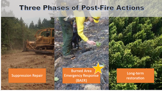
There are three phases of recovery following wildfires on federal lands:
- Fire Suppression Repair is a series of immediate post-fire actions taken to repair damages and minimize potential soil erosion and impacts resulting from fire suppression activities and usually begins before the fire is contained, and before the demobilization of an Incident Management Team. This work repairs the hand and dozer fire lines, roads, trails, staging areas, safety zones, and drop points used during fire suppression efforts.
- Emergency Stabilization-Burned Area Emergency Response (BAER) is a rapid assessment of burned watersheds by a BAER team to identify imminent post-wildfire threats to human life and safety, property, and critical natural or cultural resources on National Forest System lands and take immediate actions to implement emergency stabilization measures before the first post-fire damaging events. Fires result in loss of vegetation, exposure of soil to erosion, and increased water runoff that may lead to flooding, increased sediment, debris flows, and damage to critical natural and cultural resources.
- Long-Term Recovery and Restoration utilizes non-emergency actions to improve fire-damaged lands that are unlikely to recover naturally and to repair or replace facilities damaged by the fire that are not critical to life and safety. This phase may include restoring burned habitat, reforestation, other planting or seeding, monitoring fire effects, replacing burned fences, interpreting cultural sites, treating noxious weed infestations, and installing interpretive signs.
BAER SAFETY MESSAGE 09 17 2024
Related Incident: Davis Fire Burned Area Emergency Response (BAER)
Publication Type: Announcement
Everyone near and downstream from the burned areas should remain alert and stay updated on weather conditions that may result in heavy rains and increased water runoff. Flash flooding may occur quickly during heavy rain events--be prepared to act. Current weather and emergency notifications can be found at National Weather Service website: https://www.weather.gov/rev/.