
Incident Publication
Red Fire Daily Update for Tuesday September 17 2024 09 17 2024
Related Incident: Red Fire
Publication Type: News
Willamette Complex South & Red Fire Update
Red, 208, Moss Mountain, Coffee Pot, Tire Mountain, McKinley Creek and Chalk Fires
Date: Tuesday, September 17, 2024 Fire Causes: Lightning
Email: 2024.willamettecomplex@firenet.gov Information Phone Line: 541-208-1742
Willamette Complex South: Total Personnel: 519 | Total Willamette Complex South Acres: 23,309
InciWeb: https://inciweb.wildfire.gov/incident-information/orwif-willamette-complex-fires-south
Facebook: https://www.facebook.com/WillametteComplexFires/
Red Fire: Total Personnel: 26 | Total Red Fire Acres: 1,763
InciWeb: https://inciweb.wildfire.gov/incident-information/ordef-red-fire
Facebook: https://www.facebook.com/2024RedFireOR/
Summary
Fire behavior remains minimal across the area. The predominant observable behavior is creeping and smoldering. However, in areas with sun exposure, open, backing flames could persist. Across the multiple fires, work continues on indirect firelines and the repair of resources impacted during suppression efforts.
For fires without full containment, the growth is primarily within the existing footprints. Crews are reinforcing indirect firelines to protect priority resources if fire behavior increases. When using indirect line for suppression, achievement of full containment may only occur in areas where fire reaches the indirect lines or where firing operations off the indirect lines connect to the fire’s perimeter. Because growth remains unlikely, there are no planned firing operations to fill unburned sections between the fireline and the fire perimeter. These fires will creep and smolder until a substantial precipitation event occurs in the area. Firefighters continue to monitor for changes in fire behavior and take appropriate action to minimize acres burned.
The Chalk Fire, Coffee Pot Fire, McKinley Creek Fire, and Tire Mountain Fire are all 100% contained and in patrol and repair status. Firefighters, in collaboration with resource specialists such as archeologists, fish biologists, and hydrologists, are assessing damage from fire suppression efforts to determine necessary repair work. Repair work includes clearing culverts of debris, resurfacing roads, and chipping and hauling material removed during fireline construction. Miles of roads and numerous repair points have been identified. As crews complete the following work, they will continue to prioritize next step repair items alongside resource advisors.
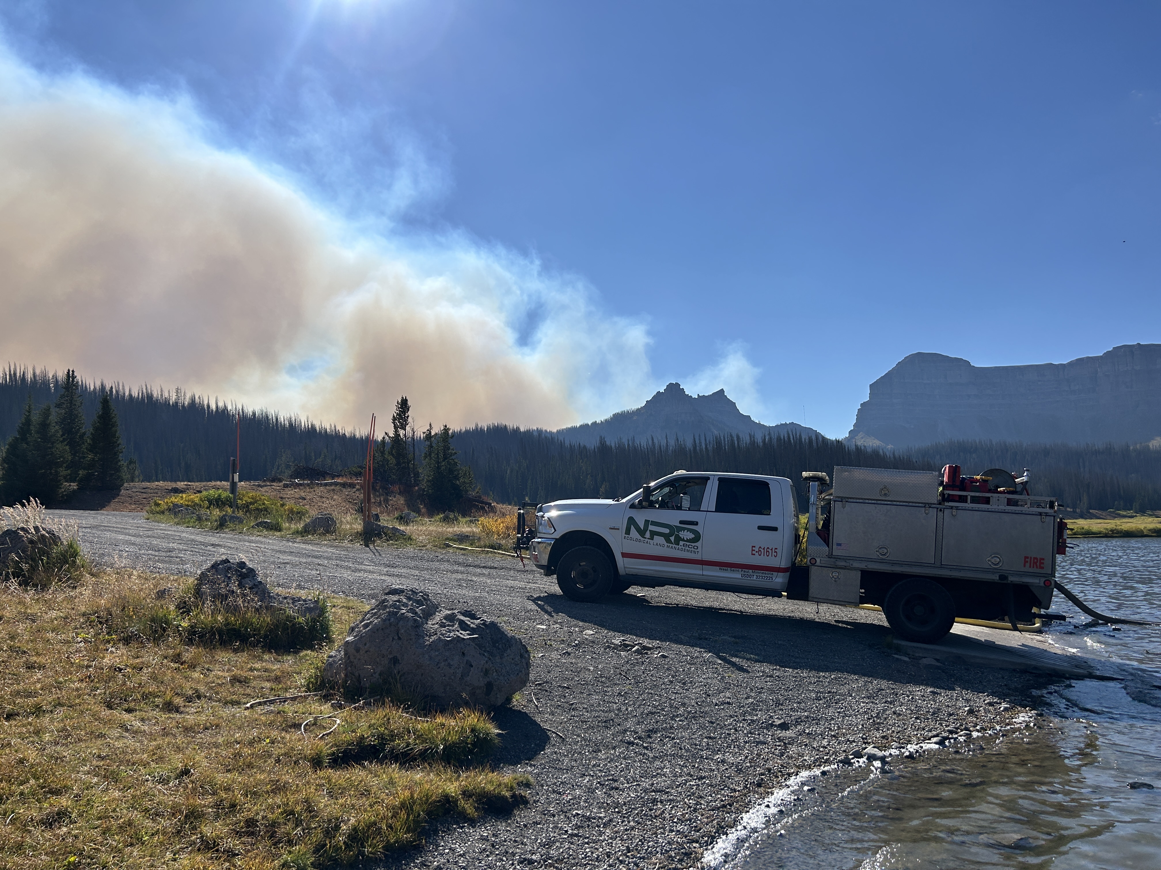
Red Fire (1,763 acres, 0% containment)
Work to haul and remove slash from Forest Service Road (FSR) 1610 is anticipated to take approximately one more week. Road repair efforts in this area are ongoing. Structure protection, portable tanks, hoses, and pumps will remain in place while fire conditions further moderate.
208 Fire (8,912 acres, 4% containment)
Falling of hazard trees was completed yesterday on FSR 21 and is likely to wrap up on along FSR 2149 in one to two more days. Material chipping will continue for five days on FSR 21 from Emigrant Creek to Emigrant Butte.
Moss Mountain Fire (2,155 acres, 10% containment)
Chipping, mastication, and removal of combustible materials is nearly complete along FSR 23. Crews are progressing south near FSR 2316 and plan to tie into existing fireline to the south along FSR 23 from the 208 Fire.
Weather and Fire Behavior
Yesterday, conditions were mostly cloudy with temperatures in the 60s. Relative humidity remained high and there was a mild, northwestern wind with maximum gusts of 10 mph. Today, a low-pressure system will move into the area with low clouds. The high temperature will be in the 50s and there is a 60 percent chance of rain in the evening. This system, and the moisture it brings, will help to further decrease fire activity.
Closures, Fire Restrictions, and Evacuations
- For closure information, visit: https://tinyurl.com/RedFireClosues2024 & https://tinyurl.com/WillFireClosures2024.
- For fire restrictions, visit: https://tinyurl.com/DesFireRestrictions2024 & https://tinyurl.com/WillFireRestrictions2024.
- The Level 1 – BE READY to Evacuate notice remains in effect for the Red Fire. For more information or to sign up for alerts, visit: www.klamathcounty.org/300/emergency-management.
Daily Update for the Frog Fire 09 17 2024
Related Incident: Frog
Publication Type: Announcement
Frog Fire Statistics:
Size: 3,105 acres
Containment: 42%
Total Personnel: 231
Location: Little Boulder Creek off East Fork
Reported: 9/7/2024
Cause: Lightning
For More Information:
Information Phone: 208-510-7856
Email: carlie_swa@firenet.gov
InciWeb: https://inciweb.wildfire.gov/incident-information/idstf-frog Facebook: https://www.facebook.com/sawtoothnationalforest
Current Situation:
Yesterday forecasted winds and light precipitation impacted the fire area in the afternoon during the operational shift. Higher RHs and cloud cover assisted in keeping the fire behavior moderated. Fire behavior consisted of smoldering, creeping, and very intermittent isolated torching along uncontained perimeter and interior pockets.
Division K was monitored and showed no new growth with light smoke interior thanks to crews efforts during previous shifts. Division A remains unstaffed and in monitor status as resources focus efforts near the head of the fire. Fire activity in Division A was moderate as fire slowly backs down slope. Resources have shifted to the head of the fire in Division Z performing checking actions on the fire where they can safely and continuing to construct indirect contingency lines to protect values at risk. Chipping operations continued in Structure South along the east fork road.
Weather permitting crews will continue with current operations today.
Weather, Fuels, and Fire Behavior:
A wet Pacific system will continue to deliver scattered to widespread showers and thunderstorms, bringing wetting rains through Tuesday. Some of the stronger storms may produce heavy rainfall and small hail. Seasonably cool temperatures are expected for the rest of the week, with isolated to scattered precipitation lingering, although conditions will trend drier later in the week.
Evacuations:
For evacuation information on the Frog Fire, please see the Custer County Sheriff’s Facebook page at https://www.facebook.com/p/Custer-County-Sheriff-Idaho-61558947312289/ and the Custer County Emergency Management Facebook page at https://www.facebook.com/ccem.idaho
To sign up for Custer County CodeRED emergency notifications, text CUSTER to 99411 or enroll online at https://public.coderedweb.com/CNE/BF28E45537FF .
Closures and Fire Restrictions:
The Frog Fire Area Closure /Forest Order: 0414-04-152 for portions of the Sawtooth National Forest can be found at this site: https://inciweb.wildfire.gov/incident-publication/idstf-frog/frog-fire-closure-09-10-2024
Fire restrictions on federal, state, and private lands may be found at this site: https://www.idl.idaho.gov/fire-management/fire-restrictions-finder/.
Wildfires are a no-fly zone for unauthorized aircraft, including drones. If you fly, we can’t. For more information, visit http://knowbeforeyoufly.org.
####
West Mountain Fires Daily Closures TFRs Evacuations Information and Important Links 09 17 2024
Related Incident: Dollar Fire
Publication Type: Closures
FOREST CLOSURES
Boise National Forest:
- Closure Order #0402-04-100 Dollar/Oro Area, Trail, and Road Closure – For Forest closure areas over the Dollar fire. For more information visit:
- https://www.fs.usda.gov/Internet/FSE_DOCUMENTS/fseprd1199005.pdf
- https://www.fs.usda.gov/Internet/FSE_DOCUMENTS/fseprd1199004.pdf
- Closure Order #0402-06-64 Anderson-Bulldog-Nellie Fire Area, Road, and Trail Closure – For Forest closure areas over the Goat and Snag Fires. For more information visit:
- https://www.fs.usda.gov/Internet/FSE_DOCUMENTS/fseprd1201350.pdf
- https://www.fs.usda.gov/Internet/FSE_DOCUMENTS/fseprd1201349.pdf
- Closure Order #0402-06-63 Lava Fire Area, Road, and Trail Closure – For Forest closure areas around the Lava and Boulder Fires. For more information visit:
- https://www.fs.usda.gov/Internet/FSE_DOCUMENTS/fseprd1203486.pdf
- https://www.fs.usda.gov/Internet/FSE_DOCUMENTS/fseprd1203488.pdf
Payette National Forest:
- Closure Order #0402-06-63 Lava Fire Area, Road, and Trail Closure – For Forest closure areas around the Lava and Boulder Fires. For more information visit:
- https://www.fs.usda.gov/Internet/FSE_DOCUMENTS/fseprd1203486.pdf
- https://www.fs.usda.gov/Internet/FSE_DOCUMENTS/fseprd1203488.pdf
FIRE RESTRICTIONS
The Boise National Forest is in Stage 1 Fire Restrictions. For more information visit: Boise National Forest.
EVACUATION INFORMATION
Valley County Sheriff’s Office is responsible for issuing and enforcing evacuation orders, and for determining the boundaries of evacuation areas. Fire managers advise the sheriff when management action trigger points are breached.
There are currently READY, SET and GO evacuation orders in place. To stay up to date with the most current information, sign up for emergency alerts, such as evacuation notices by visiting your county’s emergency alert system:
- Valley County: (208) 382-5160 https://www.co.valley.id.us/CompleteEmergencyNotificationandAlerting
- Contact Valley County Dispatch at (208) 382-5160 for information on evacuation shelters
Review the READY, SET, GO evacuation procedure for Valley County: https://www.co.valley.id.us/ReadySetGo
ROAD CLOSURES
- Warm Lake Highway Closure: Warm Lake Rd. Is now fully OPEN to the public. There are no pilot cars or time restrictions. Firefighters are still working in this area; please drive cautiously.
- 409 Rd. from Warm Lake Rd. heading south into the fire area is CLOSED. Please respect this closure; burned area is unsafe.
- National Forest System (NFS) Road 474 is now OPEN from the Boise National Forest boundary to Warm Lake.
TEMPORARY FLIGHT RESTRICTIONS
Temporary Flight Restrictions (TFR) are in place over the Boulder, Dollar, Snag, and Goat Fires. Wildfires are a no- fly zone for unauthorized aircraft, including drones. TFRs are critical for firefighter and aircraft safety. If you fly, we can’t. For more information, visit http://knowbeforeyoufly.org.
Tuesday September 17 2024 RailroadDaly Update and Map 09 17 2024
Related Incident:
Publication Type: News
September 17, 2024
Northern Rockies Team 5, Incident Commander Joe Sampson
Fire Cause Size Completion Phone # Personnel
Johnson Lightning 6,687 46% 406-401-0286 81
Sharrott Creek Lightning 3,204 83% 406-403-7976 216
Daly Undetermined 6,813 38% 406-403-7971 26
Railroad Undetermined 1,006 35% 406-403-7971 (shared with Daly)
The area closures surrounding the fires are still in effect. These closures are necessary to protect the safety and welfare of the public and provide for safe firefighter and equipment operations and access. Fire managers are working in conjunction with Bitterroot National Forest officials to assess the need and potential boundary changes.
All three incidents are downsizing as resources demobilize due to increased moisture and limited fire activity.
Current Status
Johnson (3 miles south of Springer Memorial Community, in the East Fork)
Firefighters continue to work alongside resource advisors from the Bitterroot National Forest to implement suppression repair efforts using excavators and hand tools to pull back berms on constructed firelines.
Sharrott (3 miles west of Stevensville)
Firefighters and excavators continue to implement suppression repair efforts to pull back berms on constructed firelines on the northern and southern firelines. Wood chippers work to break down large branches and tree trunks into smaller pieces, scattering available fuels alongside the constructed fireline. Fire activity is minimal due to the increased precipitation across the fire area.
Daly and Railroad (Railroad and Skalkaho Creeks confluence, 26 miles southeast of Hamilton)
Minimal fire activity is present, with no expected spread on the Railroad and Daly Fires. Crews will continue with hazard mitigation along the Skalkaho Highway (Highway 38).
Weather and Fire Behavior
The weather Tuesday will remain unstable with a widespread wetting rain expected. High temperatures will be in the low 60s. The minimum relative humidity will be around 70%. Winds will be mostly terrain driven around 5-10 mph, gusting 20-25 mph out of the west in the evening.
Fire behavior will be creeping and smoldering, primarily in stump holes, large logs, and accumulated fuels.
EVACUATIONS, RESTRICTIONS, CLOSURES
- Area closures are still in effect for all fire areas. More information on Bitterroot National Forest area closures can be found at: https://www.fs.usda.gov/alerts/bitterroot/alerts-notices
Sharrott Creek Fire Daily Update 09 17 2024
Related Incident:
Publication Type: News
The area closures surrounding the fires are still in effect. These closures are necessary to protect the safety and welfare of the public and provide for safe firefighter and equipment operations and access. Fire managers are working in conjunction with Bitterroot National Forest officials to assess the need and potential boundary changes.
All three incidents are downsizing as resources demobilize due to increased moisture and limited fire activity.
Current Status
Johnson (3 miles south of Springer Memorial Community, in the East Fork)
Firefighters continue to work alongside resource advisors from the Bitterroot National Forest to implement suppression repair efforts using excavators and hand tools to pull back berms on constructed firelines.
Sharrott (3 miles west of Stevensville)
Firefighters and excavators continue to implement suppression repair efforts to pull back berms on constructed firelines on the northern and southern firelines. Wood chippers work to break down large branches and tree trunks into smaller pieces, scattering available fuels alongside the constructed fireline. Fire activity is minimal due to the increased precipitation across the fire area.
Daly and Railroad (Railroad and Skalkaho Creeks confluence, 26 miles southeast of Hamilton)
Minimal fire activity is present, with no expected spread on the Railroad and Daly Fires. Crews will continue with hazard mitigation along the Skalkaho Highway (Highway 38).
Weather and Fire Behavior
The weather Tuesday will remain unstable with a widespread wetting rain expected. High temperatures will be in the low 60s. The minimum relative humidity will be around 70%. Winds will be mostly terrain driven around 5-10 mph, gusting 20-25 mph out of the west in the evening.
Fire behavior will be creeping and smoldering, primarily in stump holes, large logs, and accumulated fuels.
EVACUATIONS, RESTRICTIONS, CLOSURES
- Area closures are still in effect for all fire areas. More information on Bitterroot National Forest area closures can be found at: https://www.fs.usda.gov/alerts/bitterroot/alerts-notices
Johnson Fire 09 17 2024
Related Incident:
Publication Type: News
The area closures surrounding the fires are still in effect. These closures are necessary to protect the safety and welfare of the public and provide for safe firefighter and equipment operations and access. Fire managers are working in conjunction with Bitterroot National Forest officials to assess the need and potential boundary changes.
All three incidents are downsizing as resources demobilize due to increased moisture and limited fire activity.
Current Status
Johnson (3 miles south of Springer Memorial Community, in the East Fork)
Firefighters continue to work alongside resource advisors from the Bitterroot National Forest to implement suppression repair efforts using excavators and hand tools to pull back berms on constructed firelines.
Sharrott (3 miles west of Stevensville)
Firefighters and excavators continue to implement suppression repair efforts to pull back berms on constructed firelines on the northern and southern firelines. Wood chippers work to break down large branches and tree trunks into smaller pieces, scattering available fuels alongside the constructed fireline. Fire activity is minimal due to the increased precipitation across the fire area.
Daly and Railroad (Railroad and Skalkaho Creeks confluence, 26 miles southeast of Hamilton)
Minimal fire activity is present, with no expected spread on the Railroad and Daly Fires. Crews will continue with hazard mitigation along the Skalkaho Highway (Highway 38).
Weather and Fire Behavior
The weather Tuesday will remain unstable with a widespread wetting rain expected. High temperatures will be in the low 60s. The minimum relative humidity will be around 70%. Winds will be mostly terrain driven around 5-10 mph, gusting 20-25 mph out of the west in the evening.
Fire behavior will be creeping and smoldering, primarily in stump holes, large logs, and accumulated fuels.
EVACUATIONS, RESTRICTIONS, CLOSURES
- Area closures are still in effect for all fire areas. More information on Bitterroot National Forest area closures can be found at: https://www.fs.usda.gov/alerts/bitterroot/alerts-notices
West Mountain Fires Daily Update September 17 2024 09 17 2024
Related Incident: Dollar Fire
Publication Type: News
Snag, 11 miles E of Cascade, 33,300 acres, 33% contained, https://tinyurl.com/4k9dk3mu
Dollar, 18 NE of Cascade, 4,360 acres, 8% contained, https://tinyurl.com/bef6r3tz
Goat, 11 miles SE of Cascade, 26,456 acres, 0% contained, https://tinyurl.com/2h4a3dvr
Cause: Lightning (All Fires)
Personnel: 662
Special Note: This will be the last update from the Rocky Mountain Area Complex Incident Management Team 3 (RMCIMT3) for the West Mountain Fires. Tomorrow at 6am, there will be an orderly transition of command to the Great Basin Area Incident Management Team 2. RMCIMT3 is honored to have served this community.
If driving on Hwy 55 past the helicopter base just south of Cascade, please slow down and be aware of firefighter and vehicle activity. There is traffic turning into and out of the helibase from Hwy 55.
Weather and Fire Behavior: Today will be chilly and damp with more wetting rain expected. Sporadic showers should occur through much of the day, bringing another ¼” to ½” more of rain. Temperatures will range from the lower 40s on the ridges to the lower 60s in the valleys. Winds should come from the southwest but remain light at less than 10 mph. Humidity values are expected to remain in the 80 - 90 percents through much of the day. These season-slowing weather events continues to moderate fire behavior, which should be little more than smoldering at this time.
Dollar Fire:
- Rehabilitation of handline on the south side of the Dollar Fire is nearly complete.
Snag Fire:
- Warm Lake Road is open to the public, but the 409 Road extending south into the fire area from the Warm Lake Road remains closed. Please drive with caution; firefighters are still working and patrolling in this area.
- There has been very little heat at the north end of Warm Lake Road; the nearest heat is about 500 feet in from the fire’s perimeter. Nearly this entire west side of the fire in now contained.
- Rehabilitation/suppression repair is beginning along the Warm Lake Road. in conjunction with guidance from Resource Advisors.
- Crews are still working in the Warm Lake area on structure preparation and are performing chipping operations around Warm Lake neighborhood and the Fish Hatchery area.
- Firefighters are patrolling around houses in the Horsethief area.
- While rain hampered some efforts yesterday, dozer line construction continues between the fire’s edge and the Horsethief Reservoir, near Lost Basin Cutoff and the 0066 Trail.
- Chipping is complete along the Horsethief Road.
Goat Fire:
- Crews have successfully constructed fireline along the northwestern edge of the Goat Fire, from the gap between the Goat and the Snag, running to the Forest Service boundary, continuing around to the 099 Trail. Today, masticators will work to improve this line for the next several days.
- Chipping is complete along the 409 Road.
Wapiti Fire Update Tuesday 09 17 2024
Related Incident:
Publication Type: News
Wapiti Fire Statistics
- Size: 125,459 acres
- Completion: 55%
- Total Personnel: 698
- Location: Grandjean, ID
- Reported: July 24, 2024
- Cause: Lightning
For More Information
- Information Phone: 208-593-7132
- Email: 2024.wapiti@firenet.gov
- InciWeb: https://inciweb.wildfire.gov/incident-information/idbof-wapiti-fire
- Facebook: https://www.facebook.com/wapitifireinfo2024
- Linktree: https://linktr.ee/WapitiFireInfo2024
- Interactive Map: https://tinyurl.com/WapitiFireInfoMap
Special Notes:
The mixed containment and confinement strategy has been progressing on the Wapiti Fire in large part due to favorable weather and precipitation. Fall temperatures continue to support the reduction in fire behavior. Air quality and smoke outlooks have continued to improve, allowing relief for the surrounding communities and businesses.
Aviation resources continue to assist the Frog Fire but are available to support the Wapiti Fire if needed.
Current Situation:
There was no observed growth today and operational staff continue to see a reduction in fire behavior.
The east side of the fire has added containment along the Highway 21 corridor to Valley Creek. On portions of the west side and southern parts of the fire, confinement lines have been identified; these lines will be used to hold the fire in areas where it is not safe or effective to get crews on the ground. The fire has reached 55% completion between both the containment and confinement objectives. Precipitation will continue throughout the day today and tomorrow.
Divisions KK (Structure Group East), HH, and DD: Hazard tree removal and suppression repair in the Stanley Lake Recreation Area is continuing and should be completed soon. Suppression repair operations in these divisions are working to remove structure protection equipment and repair both hand and mechanical line created in the suppression efforts.
Divisions MM and PP: Firefighters worked with Resource Advisors in the division to continue suppression repair activities, in addition to the removal of hazard trees. In Division PP, north-east of Cape Horn, suppression repair activities were finalized on Monday, with crews removing the last of the structure wrap at Camp Bradley.
Division WW and Structure Group West:
Firefighters responded to a new fire start in the Blue Jay Creek area and were able to quickly bring that fire under containment. Fire activity in the area has continued to hold. Aviation resources were called in for a short period of time to cool off the 8-Mile Creek area. Structure protection remains in place though it continues to look slightly different than it did a week ago, as some pieces of equipment have been winterized and staged but remain in the area readily available if the need arises.
Division VV: Infrared flights show very little heat primarily in heavy fuels in the interior of the fire. Natural barriers, such as rocky scree and cliffs continue to hold the fire perimeter in place.
Weather, Fuels, and Fire Behavior:
Scattered rain showers are forecasted Tuesday into Wednesday morning. Beyond the added moisture the increase in cloud cover will continue to moderate areas that are still holding heat. These affects will diminish toward the end of the week as sunny days return and radiant heat will rebuild.
Evacuations:
Evacuation status for Stanley Zone 1 has changed from SET back to READY, and Stanley Zones 2-5 and Kasino are no longer in an evacuation status.
Evacuation status for Boise County on the Loman side of the Wapiti Fire has downgraded to READY, or Level 1, in all zones.
For evacuation information on the Wapiti Fire, please see the Custer County Sheriff’s Facebook page at https://www.facebook.com/p/Custer-County-Sheriff-Idaho-61558947312289/ and the Boise County Sheriff’s Facebook page at https://www.facebook.com/boisecountysheriff/.
To sign up for Custer County CodeRED emergency notifications, text CUSTER to 99411 or enroll online at https://public.coderedweb.com/CNE/BF28E45537FF
To sign up for Boise County Alert Sense emergency notification enroll online at https://public.alertsense.com/SignUp/publicUser.aspx?regionid=1163
Closures and Fire Restrictions:
The Middle Fork Complex Fire Closure Order is amended to provide consistency with the Wapiti Fire closure. This amended order, Forest Order #0402-06-64, closes the 582 and 563 roads, as well as the 579 road from its junction with 563 eastward to the junction with Highway 21. More information can be found at: https://www.fs.usda.gov/alerts/boise/alerts-notices
State Highway 21 remains closed from MP84 (Sourdough Lodge) to MP126 (Stanley Lake turn off) for public and firefighter safety.
A Wapiti Fire Area Closure / Forest Order: 0414-04-151 for portions of the Boise, Sawtooth, and Salmon-Challis National Forests can be found at this site: https://www.fs.usda.gov/alerts/sawtooth/alerts-notices
Boise National Forest Stage 1 Fire Restrictions / Forest Order: 0402-00-63 can be found at this site: https://www.fs.usda.gov/alerts/boise/alerts-notices
Sawtooth National Forest Stage 1 Fire Restrictions / Forest Order 0414-00-044 can be found at this site: https://www.fs.usda.gov/alerts/sawtooth/alerts-notices
Fire restrictions on federal, state, and private lands may be found at this site: https://www.idl.idaho.gov/fire-management/fire-restrictions-finder/
A Temporary Flight Restriction (TFR) is in place over the Wapiti Fire. Wildfires are a no-fly zone for unauthorized aircraft, including drones. If you fly, we can’t. For more information, visit http://knowbeforeyoufly.org.
Fish Creek Fire Update Tuesday 09 17 2024
Related Incident:
Publication Type: News
Northern Rockies Team 2, Incident Commander Scott Schuster
Location: 7 miles SW of Togwotee Pass
Start Date: Friday, August 16, 2024
Cause: Lightning
Size: 25,009 acres
Percent complete: 69%
Resources: 374 Total Personnel: 9 Hand Crews; 7 Engines; 13 Heavy Equipment; 1 Helicopter
KEY MESSAGES:
The fire continues to smolder in heavy timber, litter, dead and down timber, and younger mixed conifers. Minimal fire behavior is expected. Creeping, smoldering, and backing behavior of the fire will continue with an occasional single tree torching.
Firefighters and heavy equipment will continue to work in the Highway 26/287 corridor. Please drive with caution. Public and firefighter safety continues to be our highest priority on the Fish Creek Fire.
The Bridger-Teton and Shoshone National Forests updated the Closure Order for the area of the fire on Sept. 12th. These closures provide for public and firefighters safety. Please respect closed campgrounds and trails. Additional information regarding the current closure order can be found in the Forest websites.
CURRENT STATUS:
Firefighters took advantage of the favorable weather conditions over the last few days allowing for very productive shifts. Crews have continued repairing some of the disturbance caused by suppression efforts, minimizing potential soil erosion, along Deception Road from Highway 26 to Brooks Lake Lodge campground. Firefighters will continue to monitor fire behavior in the area for potential threats to the HWY 26 and other critical values.
Firefighters have made great progress on the fuels mitigation project around the structure of Togwotee Lodge. The cutting phase is complete and now removal of vegetation debris will proceed. This action will reduce the ability of the fuels to feed any fire incursion and will improve defensible space for values at risk from future wildfires.
Numerous hazards will remain in the fire area, however. Many dead trees with fire weakened roots abound, creating a fall hazards. Steep slopes that no longer have small vegetation holding soil in place can create landslide hazards as well. This is why we ask that closure areas be respected.
WEATHER AND FIRE BEHAVIOR:
The area of the Fish Creek Fire has received a significant amount of moisture across the fire zone over the last week. Forecast is for rain today, starting in the evening through late Wednesday. This period is likely to bring wetting rainfall that should further reduce fire activity.
AIR QUALITY AND SMOKE:
Aside from continued smoldering and isolated torching, the fire footprint is putting up minimal smoke. For up-to-date air quality alerts, current and predicted smoke conditions and ways to mitigate poor air quality, check out the AirNow website at https://www.airnow.gov/.
CLOSURES AND EVACUATIONS:
The joint Closure Order issued by both the Bridger-Teton and Shoshone National Forests for the fire area, remains in effect. Please do not enter the closure area or use any Forest Roads that are closed. For specific details regarding this closure, please reference the map at Fish Creek Area, Roads, and Trails Closure Order (map) and the Forest closure order fseprd1204904.pdf (usda.gov).
Under the jurisdiction of Fremont County, the areas of Brooks Lake, Pinnacle Drive and Breccia Drive remain at Level 2 “Set” Status (indicated by yellow blocks on the PIO Incident Map). A Level 2 “Set” Status means residents should be ready to evacuate at a moment’s notice. If the Level 2 Set notice changes back to a Level 3 “Go” notice, residents must evacuate until advised otherwise by Fremont County. See the alert notice on the Fremont County Fire Protection District Facebook page.
The Teton County Division of Emergency Management utilizes a Ready, Set, Go system for evacuation messaging, visit their website for additional details at www.tetoncountywy.gov/1846/Ready-Set-GO. (Indicated by green blocks on the PIO Incident Map.) They advise all residents to be in a “Ready” status by preparing for evacuations and becoming fire adapted. All residents are encouraged to sign up for Teton County, Wyoming's free alert and warning service, Teton WY Alerts at: Teton_WY Alerts - Sign Up (everbridge.net).
US HWY 26/287 is open for free-flowing traffic. Motorists may still experience smoke and sometimes limited visibility. A 45-mph speed restriction remains in effect for the fire area. Motorists are encouraged to stay alert for fire personnel and fire vehicles and use caution when travelling through the area.
The Wyoming Department of Transportation (WYDOT) continues to work closely with Fremont County Emergency Management, Fremont County Sheriff’s Office and fire officials for the safety of motorists and firefighters.
Drivers are encouraged to visit https://www.wyoroad.info/ prior to traveling on US HWY 26/287 for road status and information, or download the Wyoming 511 app at https://www.wyoroad.info/511/WY511Mobile.html to monitor for any changes due to fire activity.
Red Rock and Black Eagle Fire Update 09 17 2024
Related Incident:
Publication Type: News
Red Rock:
The Red Rock fire is estimated today to be 3,055 acres and is 7% contained. On Monday, increased fire activity was observed due to less rain than anticipated in the affected area. Fire crews took this opportunity to advance their efforts on the northern and northeastern flanks. They focused on removing fire-damaged trees, extinguishing or removing burning debris, and cooling down ash to strengthen firelines and contain the blaze within its established perimeter. Meanwhile, on the southern side, teams worked alongside resource advisors to identify the best access points for direct fire attacks.
Today, crews continue to work with resource advisors to identify suitable locations on the eastern side of the fire for constructing both hand and dozer lines. This work will go southward towards the 4th of July trail system to ensure the fire remains within its current footprint. In the southern area, crews will work to remove hazardous trees. With arrival of additional resources, crews can start constructing direct fire lines.
Black Eagle:
The Black Eagle fire is estimated today to be 6,451 acres and is 0% contained. Yesterday, fire crews focused on removing extra equipment from the Yellowjacket Ranger Station in preparation for bad weather. At Black Eagle Mine, personnel used aircraft to drop water and construct firelines around spot fires.
Today, crews will continue to tackle the spot fires in Black Eagle Creek by constructing more handlines and strengthening existing firelines. Helicopters will assist with water drops if weather conditions allow. Additionally, teams will check that pumps and sprinklers on critical infrastructure are ready for use if needed.
WEATHER:
The forecast for today calls for periods of moderate rainfall, with totals around 0.5”. Temperatures are expected to reach 48°, with high humidity. Winds will be from the west-southwest, with gusts possibly reaching 40-50 miles per hour.
FIRE BEHAVIOR:
There will be decreased fire behavior today due to the expected precipitation. In areas of the fires with canopy cover or in areas of lighter rainfall, fire behavior will remain the same as yesterday. Fire spread may still occur in heavier fuels like large-diameter logs or because of rollout, when smoldering fuels roll from one point to another.
FOREST CLOSURES:
Forest Closure Orders 04-13-24-017 and 04-13-24-019 remain in place. For more information please visit: https://www.fs.usda.gov/alerts/scnf/alerts-notices
EVACUATIONS:
Lemhi County: Evacuation order and warnings remain in effect. For more information, please go to: https://www.lemhicountyidaho.org/site-home/news/black-eagle-and-red-rock-fire-update.
Evacuation Zone 1 is in “Go Status,” and Evacuation Zones 2, 3, and 4 are in “Ready Status.