
Incident Publication
Bridge Fire Community Meeting at Serrano High School on 09 14 2024
Related Incident: Bridge Fire
Publication Type: Announcement
Bridge Fire Community Meeting
Saturday, September 14, 2024
6:00 - 8:00 p.m.
Serrano High School Performing Arts Center
9292 Sheep Creek Rd. Phelan, CA 92371
The meeting will also be live-streamed on the Angeles National Forest Facebook page:


Davis Fire Update 09 13 2024
Related Incident: Davis Fire
Publication Type: News
Southwest Area Incident Management Team Update for Wednesday, September 13, 2024
Acres: 5,824 acres
Start Date: 09/07/2024
Location: Washoe Valley, Nevada
Personnel: 685
Containment: 56%
Fuels: Timber
Resources: 10 Crews | 14 Helicopters | 71 Engines | 5 Water Tenders | 4 Dozers
Highlights: Crews continued reinforcing existing fire lines, completing approximately 2,000 feet of handlines near Slide Mtn. Five to ten acres of unburned fuel pockets (islands) were intentionally burned near Winter Creek Rd. to eliminate flammable materials like leaves, pine needles, and small limbs. Isolated areas of large logs and stumps, or ‘heavies,’ are still smoldering and producing light smoke. Additional containment was secured along the fire perimeter. Aviation resources will remain available today. Water tenders and portable tanks have been strategically placed to strengthen firefighting efforts.
Smoldering and creeping fire activity is expected, with isolated pockets of smoke still visible. Firefighters will continue mop-up efforts, working over 100 feet inside the fire lines. The fire lines are dozer lines, handlines and existing road systems. Mop-up operations will focus on all areas where heat is detected, with particular attention along the fire perimeter near Davis Creek Rd, progressing northwest past Hidden Lake and up to Mt. Rose Highway. Mop-up includes extinguishing hot spots with water, stirring burning vegetation with hand tools, and trimming lower limbs to prevent the fire from reaching the tree canopies. Crews will patrol fire lines to ensure embers remain contained and will remove any hazardous, burned trees at risk of falling across fire lines or roads.
Weather: Forecast warmer and drier conditions for today. The relative humidity is expected to drop down into the teens. Winds will be primarily out of the east, but also affected by the steep slopes (terrain driven). Expect breezy conditions over the weekend. Temps will be in the mid-80s on Saturday and dropping down to the mid-70s on Sunday.
Evacuations: We urge everyone to remain vigilant and stay clear of evacuation zones. Stay informed by relying on official fire information sources.For updates on evacuation statuses please visit: https://perimetermap.com
To sign up for code red alerts and warning visit https://www.washoecounty.gov/em/RegionalAlerts.php
Fossil Complex AM Update 09 13 2024
Related Incident: Fossil Complex
Publication Type: News
Warmer and Drier Weather Returns Over Fires
SPRAY, Ore. – Warmer and drier weather is returning to the fire areas which will increase fire activity. Crews have made a lot of progress with the cooler and wet weather in preparation to a return to these conditions. The west and northwest edge of the fire is plumbed with hose lay and crews are building the rind in that section of the fire. From the north to the northeast section of the fire crews will continue laying hose in preparation to start mopping up. The east side of the fire had fire activity within the perimeter late in the day yesterday. Crews will continue cold trailing along the fires edge and extinguish any areas with active fire to secure the line. The southwest to south point along ORE 19 is in mop up. ODOT opened Ore 19 early Friday morning. Check for updates on ODOTs TripCheck - https://tripcheck.com/
With the warmer and drier weather air resources will be fully available to the ground crews today.
Community members in Spray attended a community meeting and heard updates from ODF Operations, the Incident Meteorologist, Dustin Gustaveson John Day Unit Forester, Jeremiah Holmes Fire Defense Board Chief, and Matt Howard Incident Commander.
Videos: Due to an issue with the Fossil Complex Facebook page, recordings of the Daily Operations Updates and other stories will be available at: https://www.youtube.com/@FossilComplex.
The Wheeler County Sheriff’s Office has reduced all evacuations outside of the fire’s perimeter. Level 3 evacuations remain in place inside the perimeter of the Service Fire. For the most recent evacuation levels please go to: https://www.facebook.com/WheelerCountySheriffsOffice/
The Two Cabin, Holmes, Kinzua and Canyon Fires are all in patrol status.
Flying unauthorized drones is hazardous to aircraft and will ground critical aerial operations.
Diamond Complex and Middle Fork Fire Update 09 13 2024
Related Incident: Middle Fork Fire
Publication Type: News
Current Situation: California Interagency Incident Management Team 14 assumed command of the Diamond Complex and Middle Fork Fire as of 7:00 a.m. today, September 13, 2024. A weather system brought significant rains throughout the fire area Wednesday and into Thursday morning. Cold overnight temperatures near freezing were observed into this morning. A quick warming and drying trend is forecasted for today and into Saturday, while cooler temperatures, higher humidity and another weather system arrives the latter half of the weekend. This moisture and decrease in temperature have minimized fire activity but have also created access issues for crews on many of the roads. Fire personnel will take advantage of this dry weather period to continue making progress on their operations.
Diamond Complex: The Diamond Complex includes 33 fires in the Umpqua National Forest, 31 of which are 100% contained. Crews continue suppression repair work as well as patrolling and mopping up any remaining areas of interior heat. Due to recent rain and current weather, all fires are anticipated to stay within current containment lines.
The remaining two fires that are not yet fully contained are the Pine Bench Fire (3,976 acres, 66% contained) and the Potter Fire (3,428 acres, 76% contained). Crews assigned to these fires are constructing primary control line along remaining sections of the fire perimeter while continuing to patrol and mop up interior heat, ensure containment lines hold, and remove unneeded equipment.
Middle Fork Fire: The fire perimeter continues to hold with no new growth. Reconnaissance flights over the fire area revealed no significant heat sources. Crews have completed suppression repair operations along the Pacific Crest Trail. Crews will continue to monitor the fire via vantage points and with a helicopter while also completing suppression repair work east of Route 230 in the Rogue River-Siskiyou National Forest.
Closures: Umpqua National Forest lands, roads, and trails around the Diamond Complex fires are temporarily closed (with several exemptions) under Forest Order 06-15-24-07. Due to the Middle Fork Fire, Rogue River-Siskiyou National Forest lands, roads, and trails west of Crater Lake National Park are also temporarily closed under Forest Order 06-10-24-24-02. You are responsible for knowing where you are in relation to the closed areas, so be prepared and view the orders and maps prior to recreating on your public lands. Crater Lake National Park is open; however, several trail closures are in effect.
Fire Restrictions: On the Umpqua National Forest, fire danger is set at High and Public Use Restrictions Level 2 are in effect. Campfires must be in Forest Service constructed fire rings or fireplaces in designated sites and are not allowed in dispersed sites or in wilderness areas.
Diamond Complex (Umpqua National Forest)
Size: 11,141 acres
Containment: 86%
Personnel: 492
Middle Fork Fire (Crater Lake National Park)
Size: 5,286 acres
Containment: 70%
Personnel: 11
###
Next update to be released 9-15-2024
West and Preacher Fires Update 09 13 2024
Related Incident: 2024 - West Fire - TNF2024 - Preacher Fire - TNF
Publication Type: News
Infrared flight provides more accurate acreage
Highlights/Operations: Firefighters anticipate beginning ignitions on the West Fire again today after holding multiple days through higher winds. With the previous ignitions providing a buffer of burned area on the northern and northeast side of the planned perimeter, the focus now is on igniting from the Rim Road south through Bray Creek as well as on the east side, adding another section of fire towards the southeast to around Milk Point Flat. The ignition strategy is to have fire continue to gently back down the slopes around Camp Geronimo and carefully apply fire to protect those structures if needed. Helicopters with water buckets are available to assist crews. This ignition plan is designed to remove an unnatural build-up of potentially dangerous fuels, restore fire to the ecosystem that depends on it and fully contain the West Fire within the planned perimeter. Crews and dozers have constructed a contingency line east of Bray Creek along FR 646 road in the event it is needed. They are also finishing the removal of fuels with heavy equipment along the Control Road from Bray Creek to SR 87.
On the Preacher Fire, the small amount of fire that crossed the perimeter near Wildcat Springs was lined and mopped up yesterday. Engines continue to patrol the entire perimeter and crews are extinguishing any hotspots close to the perimeter’s edge. Interior pockets of fuel continue to burn as fire moves around. At times residents will see smoke. The fire is still being staffed day and night to ensure everything is secure.
Weather: Winds will decrease a bit for Friday while remaining out of the southwest. Expect gusts between 18 and 23 mph during the afternoon, highest above 6,000 feet. High temperatures on Friday will be in the mid-70s to around 80 degrees. Minimum relative humidity will average 20 to 25 percent.
Safety: Two Temporary Flight Restrictions (TFR) are now in place over the area, which includes uncrewed aircraft systems or drones. The public is reminded, if you fly we can’t; unauthorized drone flights pose serious risks to firefighter and public safety and the effectiveness of wildfire suppression operations.
Closure: The Tonto National Forest has issued a closure for land surrounding the West Fire, this includes Pine Trailhead.
Evacuations: Some residents east of Payson near the Preacher Fire have been moved to SET status and Geronimo Estates residents near the West Fire have also been placed in SET status. An interactive map is available to stay up to date with evacuation levels related to both the West and Preacher Fires.
Receive emergency notifications from Gila County.
Smoke: During ignitions, smoke may settle in low-lying areas overnight. Residents are encouraged to close windows at night to avoid smoke impacts. Talk with your doctor and plan for how to manage your health conditions when it is smoky. Additional resources for how to prepare for wildfire smoke.
For the latest news and information about the Tonto National Forest, follow along on Facebook @TontoNationalForest, ‘X’ (formerly Twitter) @TontoForest or Instagram @tontonationalforest and on the Tonto National Forest website.
Red Fire Daily Update for Friday September 13 2024 09 13 2024
Related Incident: Red Fire
Publication Type: News
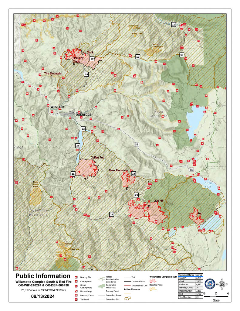
Willamette Complex South & Red Fire Update
Red, 208, Moss Mountain, Coffee Pot, Tire Mountain, McKinley Creek and Chalk Fires
Date: Friday, September 13, 2024 Fire Causes: Lightning
Email: 2024.willamettecomplex@firenet.gov Information Phone Line: 541-208-1742
Willamette Complex South: Total Personnel: 626 | Total Willamette Complex South Acres: 23,197
InciWeb: https://inciweb.wildfire.gov/incident-information/orwif-willamette-complex-fires-south
Facebook: https://www.facebook.com/WillametteComplexFires/
Red Fire: Total Personnel: 70 | Total Red Fire Acres: 1,732
InciWeb: https://inciweb.wildfire.gov/incident-information/ordef-red-fire
Facebook: https://www.facebook.com/2024RedFireOR/
Summary
Today’s operations will concentrate on the completion of primary control lines to limit fire impacts to the identified values at risk. As Incident Commander, John Szulc stated, “We’re going to move with purpose.” Backhaul operations continue on the Moss Mountain, Coffee Pot, and Chalk fires, focusing on the removal of unused hoses and supplies. Where conditions permit, snagging, brush pile removal, and the maintenance of secondary and interior roads remain priorities.
Red Fire (1,732 acres, 0% containment)
Firefighters continue constructing shaded fuel breaks, removing smaller trees and underbrush while leaving larger, more fire resistant trees in place. All deployed structure protection equipment will continue to be checked and maintained in the event of unforeseen changes in fire behavior. As temperatures drop and the forecast predicts more moisture, resource needs in this area are being reevaluated while focusing on actions to minimize acres burned.
208 Fire (8,843 acres, 0% containment)
The fire growth towards Fire Service Road (FSR) 23 Road in the northwest and FSR 21 and 2154 in the south. Crews are actively reinforcing these roads to complete a fireline from FSR 23 to FSR 423. The objective is to connect this line with the existing fireline from the Moss Mountain Fire.
Moss Mountain Fire (2,133 acres, 8% containment)
Primary and contingency lines along FSR 23, 2120, 490, and 2309 are being reinforced and patrolled for changes in fire behavior. Crews continue to strengthen firelines by removing excess slash and other vegetation from these control features.
Chalk Fire (5,987 acres, 86% containment)
Firefighters are actively monitoring and improving containment lines on the south, east, and north sides of the fire. On the west side, crews are enhancing firelines along FSR 1912 and connecting them back to the fireline on FSR 1925. Monitoring of the unburned fuel island on the northwest side of the fire is ongoing.
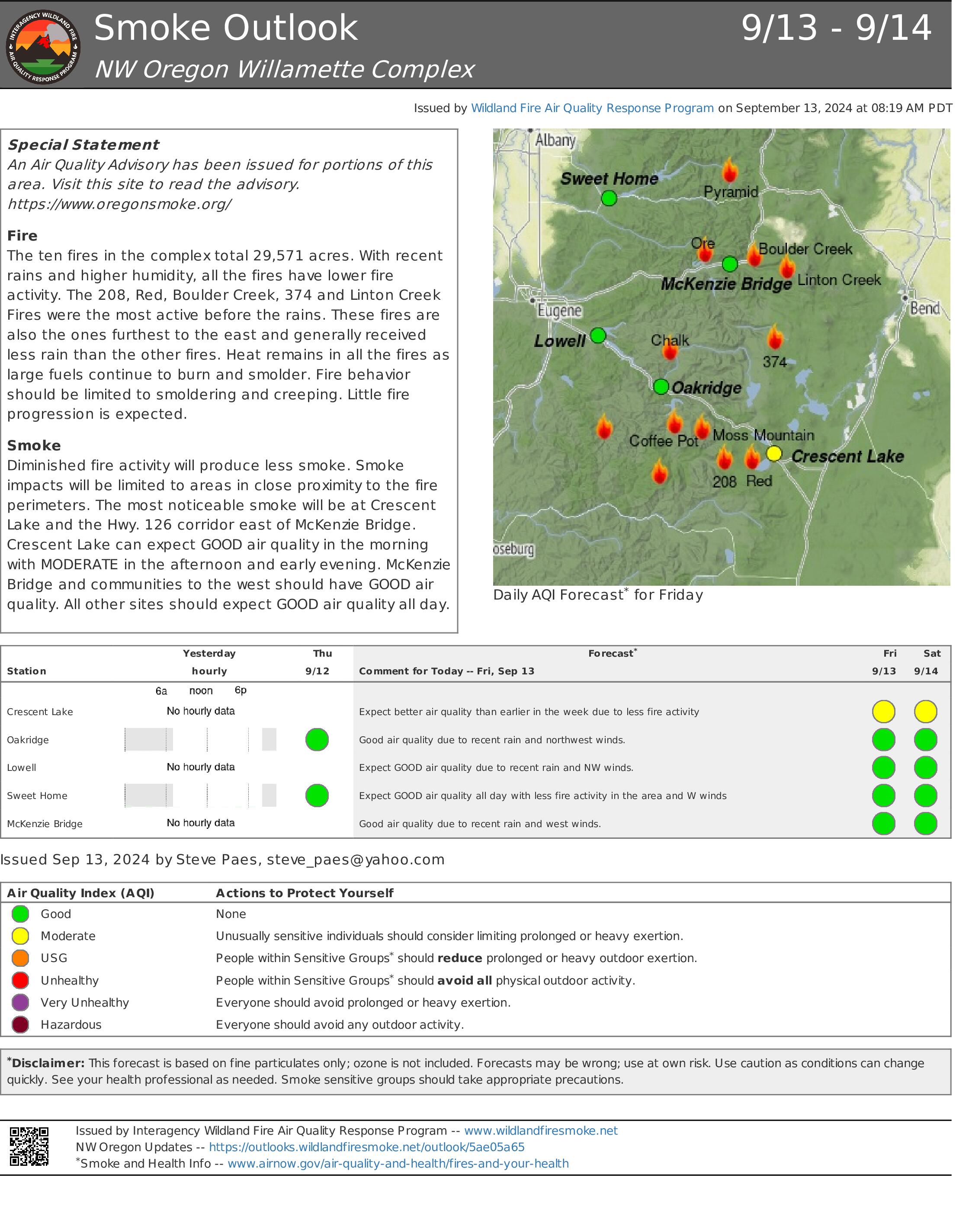
Weather and Fire Behavior
Yesterday, skies stayed mostly cloudy, keeping relative humidity high in the area. The fires within the complex showed minimal growth. Looking ahead, a low-pressure system is expected to bring increased cloudiness and moisture tomorrow through early next week. Continued high humidity and the cooling trend should sustain the current creeping and smoldering fire behavior.
Closures, Fire Restrictions, and Evacuations
- For closure information, visit: https://tinyurl.com/RedFireClosues2024 & https://tinyurl.com/WillFireClosures2024.
- For fire restrictions, visit: https://tinyurl.com/DesFireRestrictions2024 & https://tinyurl.com/WillFireRestrictions2024.
- For current Temporary Flight Restrictions (TFR), visit: http://tfr.faa.gov.
- The Level 1 – BE READY to Evacuate notice remains in effect for the Red Fire. For more information or to sign up for alerts, visit: www.klamathcounty.org/300/emergency-management.
Homestead Complex and Lane 1 Fire Update 09 13 2024
Related Incident: Lane 1 Fire
Publication Type: News
Homestead Complex and Lane 1 Fires
Update for Friday, September 13, 2024
Firefighters began to reengage in suppression and repair operations within the complex as conditions on the ground began to recover from the recent heavy rains. Three of the seven fires on the Homestead Complex are 100% contained, the Salmon 33 Fire (275 ac.) on August 24, 2024, the Reynolds Butte Fire (334 ac.) on August 22, 2024, and the Lost Bucket Fire (34 ac.) on July 29, 2024.
Homestead Complex Fire
Start Date: July 19, 2024
Size: 9,483 acres
Overall Containment: 31%
Personnel: 452
Location: 30 miles NE of Glide, OR
Cause: Lightning
Fire Information: https://tinyurl.com/25vkhfjp
Lane 1 Fire
Start Date: July 17, 2024
Size: 25,951 acres
Containment: 99%
Personnel: 92
Location: Approx. 16 miles SE of Springfield, OR
Cause: Lightning
Fire Information: https://tinyurl.com/29k3nnly
Fire Operations Summary:
Yesterday on the Horse Heaven Fire (2,715 acres, containment: 56%), crews completed the remaining section of ground needing control line on the north flank going west down into the Horse Heaven Creek. Work will continue today on establishing line and access into Horse Heaven Creek from northwest side of the drainage. Crews will continue with mop-up operations on lined spots just north of the north flank. Work on other flanks of the fire continued with road clean-up, chipping and log hauling.
On the Fuller Lake Fire (3,516 ac., containment: 0%) yesterday, road conditions on the east flank remained too saturated from the heavy rains to allow for the needed heavy equipment operations along roads. Crews worked finishing mopping a slopover along the southeast corner. Fire managers continued scouting for dozer line locations. On the west flank, operations were able to proceed with cutting-out trees blocking the 3810 Road where the fire had previously crossed. Crews also continued mopping up a spot fire on the southwest corner near the 3810 Road. Today, the plan is to continue with mopping-up, chipping operations, road clearing and clean-up, and locating additional control lines.
The Bullpup Fire (520 ac., containment: 7%) remains stationary within control lines. Yesterday, crews were busy with chipping and road clean-up on the 200 Road that is serving as a primary control line. Crews also pulled 30,000 feet of hose and fittings from the 300 Road system. The priority objective for fire managers is to prevent the fire from progressing further north toward critical habitat for wild steelhead (the Frank and Jeanne Moore Wild Steelhead Special Management Area).
On the No Man Fire (2,089 ac., containment: 44%), crews will be patrolling, mopping-up, chipping, hauling logs and conducting suppression repair operations. Suppression repair work will also continue on the Reynolds Butte and Lost Bucket fires.
On the Lane 1 Fire (29,951 ac., containment: 99%), clean-up and suppression repair work will continue around the fire. The work includes chipping vegetation and log hauling operations, and repairing forest road infrastructure. This work will also make it safer for the public once closures to public managed lands are removed.
Closures and Fire Restrictions:
There are two closure orders impacting every district of the Umpqua National Forest https://www.fs.usda.gov/alerts/umpqua/alerts-notices. The forest is in High Fire Danger with Public Use Restrictions (PURs) at Level 2: https://www.fs.usda.gov/detail/umpqua/fire/?cid=FSEPRD937986
The closure order issued by Bureau of Land Management (BLM), Roseburg District, for portions of BLM land which border the Umpqua National Forest Emergency Fire Closure north of Steamboat remains in effect: https://www.blm.gov/sites/default/files/docs/2024-07/orwa-fpo-rbg-072624.pdf
Weather: Today will be warmer and drier across the fire. Temperatures will rise into the 60s and lower 70s. Winds will be from the north at 4 to 8 mph, with occasional gusts up to 10 mph.
There is a Temporary Flight Restriction (TFR) over the fires. Please remember, if you fly we can’t! If a drone or other aircraft enters the air space, all firefighting aviation equipment will be grounded.
Fire Information Line: 541-208-7100 (Staffed 8 a.m. to 8 p.m.)
Email: 2024.homesteadcomplex@firenet.gov
Facebook: https://www.facebook.com/HomesteadComplexFireInfo/
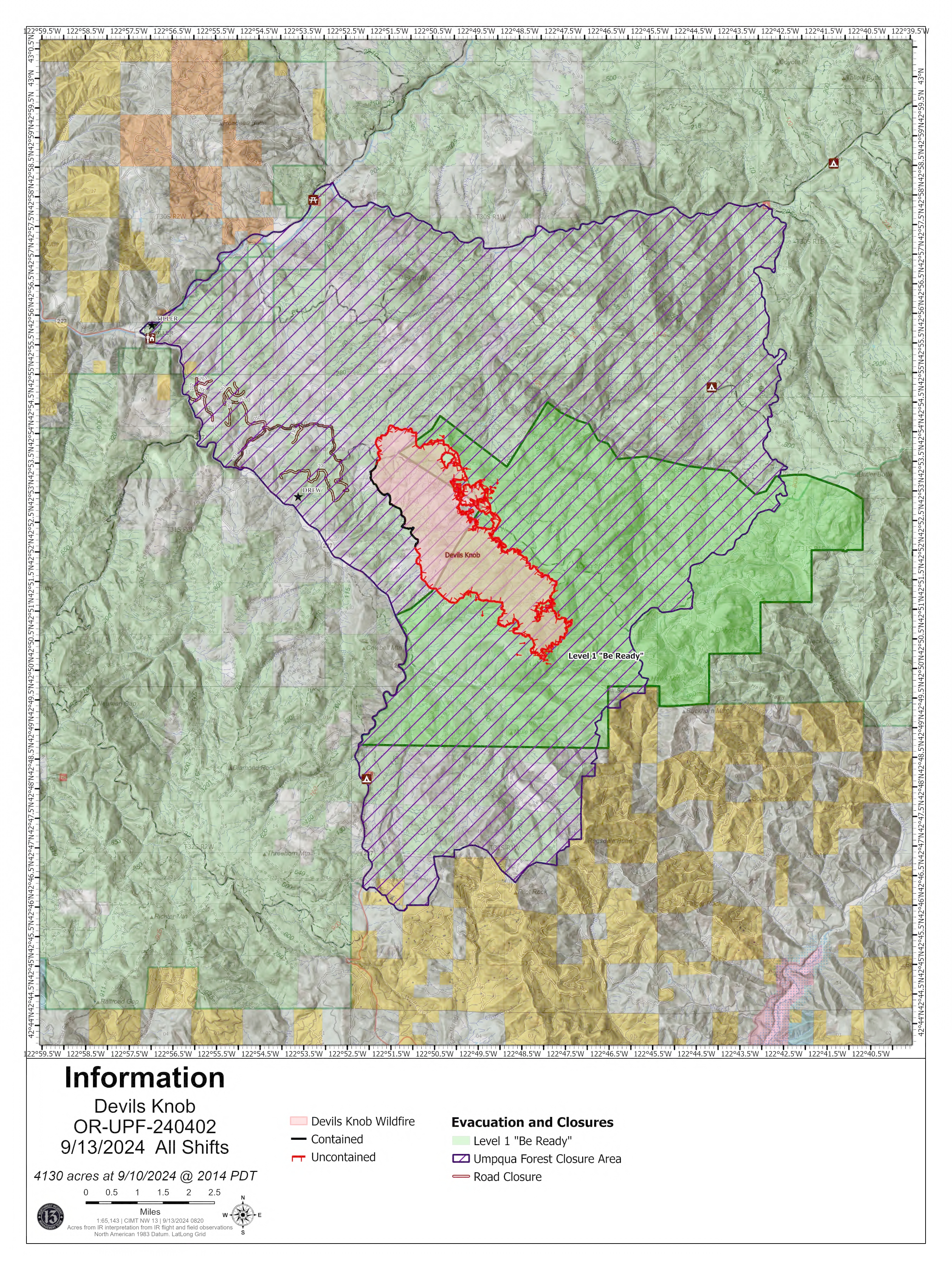
Devils Knob and Milepost 98 Daily Update 09 13 2024
Related Incident:
Publication Type: News
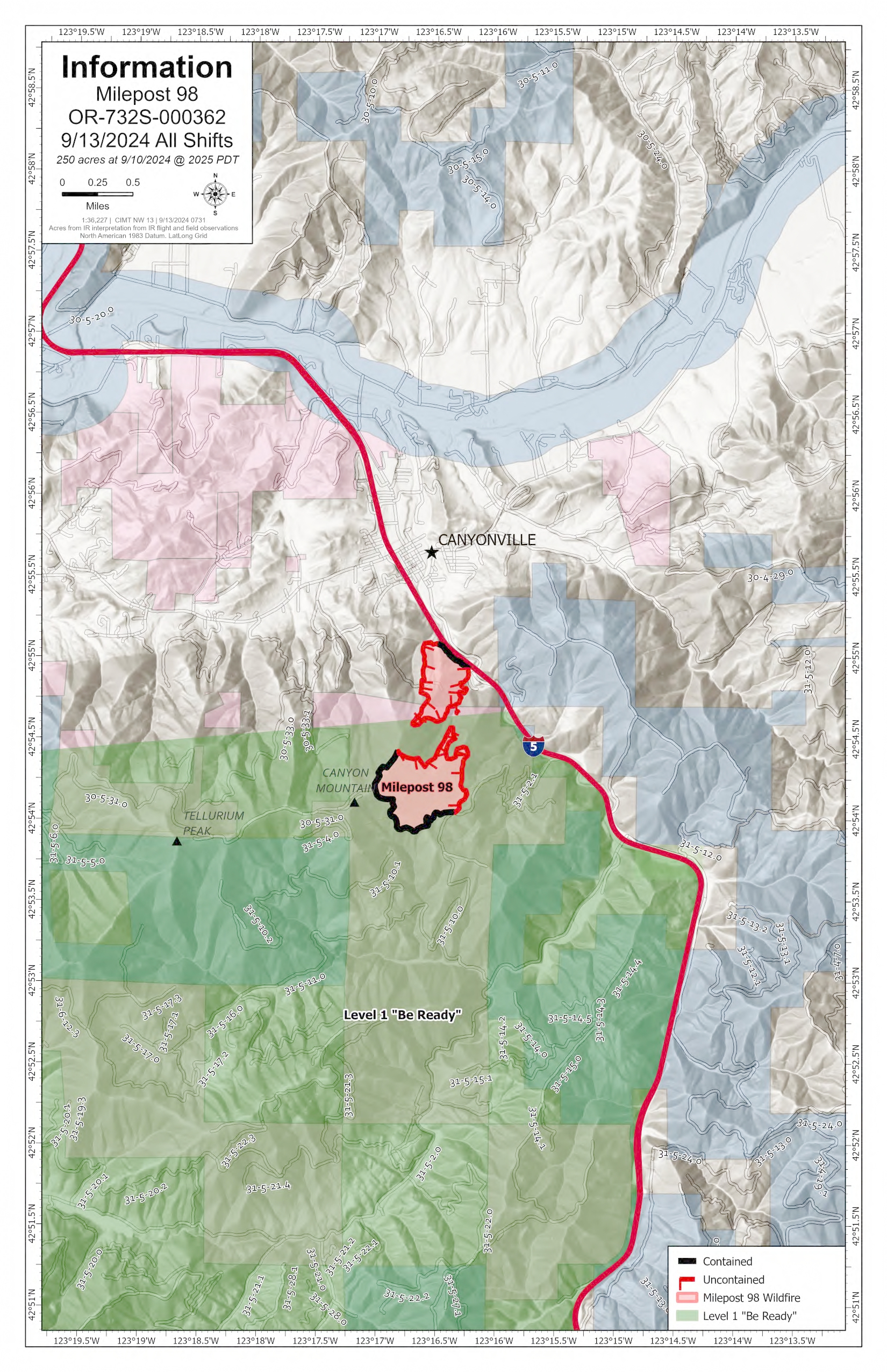
Devil’s Knob and Milepost 98 Fire Update for Friday, September 13, 2024
KEY MESSAGES:
The Douglas County Sheriff's Office has downgraded several evacuation levels for the Devil's Knob and Milepost 98 Fires. An interactive map reflecting these evacuation levels can be found online at www.dcso.com/evacuations. Currently, no Level 3 (GO NOW) or Level 2 (BE SET) evacuation notices exist for either incident. Level 1 (BE READY) evacuation notices apply to all residences on Joe Hall Road, Tison Road, Elk Diamond Road, and Ritchie Road. Residents who have been placed on any level of evacuation notice and those living in proximity of the fires should continue to monitor official sources for updated information. Any changes to these evacuation notices will be communicated through official channels.
Due to decreased fire activity, only one update will be posted daily.
CURRENT STATUS:
Devil’s Knob- Resources: 673, Crews: 19, Engines: 16, Water Tenders: 11
Mop-up and patrol operations continue around the fire perimeter. On the eastern flank, crews continue snagging operations to reduce hazard trees and plan to begin tethered dozer operations in steep terrain. Along the southern flank, heavy equipment is being put in place to continue securing the fire’s edge in the Flat Creek area.
Milepost 98- Resources: 288, Crews: 11, Engines: 12, Water Tenders: 8
Firefighters continue reinforcing fire lines and conducting mop-up and patrol operations around the perimeter. Tree fallers are engaged in snagging operations to remove hazard trees that may have been damaged in the fire and have the potential to fall. Roads in the area are being assessed for transition back to the local unit.
WEATHER / FIRE BEHAVIOR:
Yesterday was another damp day, which reduced fire behavior with cool temperatures predominantly in the 50s, relatively light winds and clearing skies in the afternoon. Dry, warmer weather returns today and tomorrow, with additional rain anticipated early next week. These conditions continue to moderate fire activity throughout the area.
SAFETY AND CLOSURES:
Closures on the Umpqua National Forest can be found at https://www.fs.usda.gov/alerts/umpqua/alerts-notices. Additionally, Umpqua National Forest remains in High Fire Danger, Public Use Restrictions Level 2, and Industrial Fire Precaution Level 2. For more information on fire restrictions, visit https://www.fs.usda.gov/main/umpqua/fire.
Fire Restrictions for Bureau of Land Management can be found on the Oregon-Washington blm.gov page.
Oregon Department of Forestry restrictions can be found at https://www.oregon.gov/odf/fire/pages/restrictions.aspx.
Douglas Forest Protective Association restrictions can be found at https://www.dfpa.net/public-fire-restrictions.
Middle Fork Complex Update 09 13 2024
Related Incident:
Publication Type: News
Firefighters Taking Advantage of Wetting Rain to Strengthen Containment Lines
The Middle Fork Complex is 61,159 acres, with 32% completion. There are 621 personnel assigned. A warming and drying trend will begin today with mostly sunny skies and higher temperatures climbing into the 60 and 70s. Relative humidity will drop to 30-40% by the afternoon. Little fire activity is expected today as recent stormy weather has provided a wetting rain, giving firefighters the opportunity to strengthen containment lines throughout the Nellie and Bulldog Fires.
Falling trees are a major concern after the recent storm. Many trees within this region have shallow root systems and disturbances such as high winds, thunderstorms, and fire can result in the weakening and tipping over of these trees. Firefighters are working to remove hazard trees along roadways, for safety.
Heavy equipment are grading roads throughout the Bulldog and Nellie Fire areas, improving road conditions due to heavy firefighter traffic. Additionally, equipment operators continue chipping and masticating along roadsides, widening contingency lines on the 698 and 671 Roads to Silver Creek and the 555 Road north of the fire perimeter to Deadwood Outfitters. Masticators grind, chip, or break apart fuels such as brush, small trees and slash. Firefighters are using this technique to widen contingency lines by removing vegetation along roads. Crews also continue removing vegetation around the Silver Creek Plunge and Boiling Springs areas.
On the southern end of the Nellie Fire a debris slide occurred on the 555 Road near Highway 17. Firefighters are exploring options to mitigate this hazard as the area remains unstable. The southern section of the Nellie Fire, parallel to Highway 17 (Banks Lowman Road), continues to show limited fire activity. On the north end of the Nellie Fire, firefighters continue to mop up hot spots around the Deadwood Reservoir area.
There will be a community meeting today, September 13, at 6 p.m. at the White Barn Building, near 85 Severance Road, Garden Valley, Idaho. The recording will be posted on Inciweb, YouTube, and Facebook.
Boise National Forest Closure Order Number 0402-06-64 remains in effect. An interactive forest closure map is available on the Boise National Forest Alerts & Closures website, https://www.fs.usda.gov/alerts/boise/alerts-notices.
Hunters are not allowed access to these closed areas.
Highway 21 is closed from the Sourdough Lodge in Lowman to Stanley Lake Road (MP 84 to 126) due to nearby wildfire activity. Only local traffic is allowed between the Sourdough Lodge and Warm Springs Airstrip. There is no public access from the highway to surrounding areas including Grandjean, Bull Trout, Boundary Creek, Cape Horn, or Seafoam. For more information, visit the Idaho Department of Transportation website, https://511.idaho.gov/
Learn how to prepare your home for wildfire. Visit the Firewise website for wildfire risk reduction steps that you can take to make your home safer during a wildfire: Firewise Website: https://www.nfpa.org/en/Education-and-Research/Wildfire/Preparing-homes-for-wildfire
Wildfires are a No Drone Zone. If you fly, we can’t. Every time a drone is spotted near the fire all aircraft are grounded until we can be sure the drone is clear of this area. Visit Know Before You Fly, http://knowbeforeyoufly.org. A Temporary Flight Restriction (TFR) is in effect in the fire area.
Fire Information: 208-992-3045 (8am – 8pm) Email: 2024.middleforkcomplex@firenet.gov
Inciweb: https://inciweb.wildfire.gov/incident-information/idbof-middle-fork-complex-fire-bulldog-and-nellie
Facebook: https://www.facebook.com/people/Middle-Fork-Complex-Fire-Boise-National-Forest/61565022204468
Williams Mine Fire Update 09 13 2024
Related Incident: Williams Mine Fire-GPNF
Publication Type: News
Williams Mine Fire Update for Friday, September 13, 2024
The Williams Mine Fire received a few showers Thursday, and higher humidity and cooler temperatures kept the fire quiet despite gusty winds. Fire personnel continue to check for hot areas near the fire’s edges while working on repairing damage caused by the fire suppression efforts.
Containment on the Williams Mine Fire has been holding at 31% since August 27. This containment is on the southern portion of the fire perimeter toward Trout Lake. Containment means control lines have been established, fuels adjacent to the lines have been burned or reduced to a level that will not support fire, and hot areas near the fire line have been extinguished. There is minimal chance that fire will cross a contained portion of the fire edge.
Most of the rest of the fire perimeter is in the Mt. Adams Wilderness or is on rugged or remote ground. Since this is a lightning or natural fire, most of the fire activity in the Wilderness is being monitored but not suppressed. Action is being taken when fire threatens other values, such as recreation sites and the Yakama Reservation.
On rugged ground, it is difficult and dangerous to build and hold direct fire lines, especially on steep slopes and in areas with many dead trees. Lines often need to be dug by hand, and burning material can roll downhill past them. Falling snags have been a constant threat. Indirect control lines have been established instead, to the southwest and west of the fire and east of Snipes Mountain. The indirect lines were established along roads or in other places where people and equipment could work safely and efficiently. They offer a better opportunity to stop the fire’s growth than direct line would, and at a lower risk to firefighters.
In some areas, the fire spread to the indirect lines, and they became containment lines. In many areas, the fire has stalled upslope of indirect control lines, and is still uncontained but not growing. Overall containment is likely to stay low on this fire.
SAFETY AND CLOSURES:
As we head into the weekend, watch out for heavy traffic, including motorcycles and bicycles on roads. Look twice before pulling into traffic or making a turn.
The Confederated Tribes and Bands of the Yakama Nation, Tract D Recreation Area is currently closed, please see Yakama Tract D Road Closure for more information. FS Rd 23 south of FS Rd 90 is still CLOSED to the public due to fire suppression activity. Takhlakh Lake is still closed. The revised closure for the Mt. Adams Wilderness and FS Rd 23 closure can be found at Williams Mine Fire: Area and Road Closure. The Pacific Crest Trail (PCT) is closed from the PCT's intersection with FS Rd 23 to Potato Hill. The current area closure spans the entire Mt. Adams Wilderness.