
Incident Publication
Coffee Pot Daily Update 09 09 2024
Related Incident: Coffee Pot Fire
Publication Type: News
CURRENT SITUATION: Air operations played a key role in yesterday's efforts; fixed and rotor-wing aircraft dropped retardant from Horse Creek to the East Fork Kaweah River, delivered equipment to spiked-out crews, and continued strategic bucket drops on the northeast portion of the fire. Water tenders applied retardant along Mineral King Road, east of Horse Creek, and Wildland Fire Modules (WFM) constructed direct handlines near Homers Nose. Crews focused on backhauling equipment, addressing hazardous trees, and mopping up deeper into the fire line along the southern and western flanks.
Today, crews will continue constructing indirect handlines from Mineral King Road to the East Fork Kaweah River, using firing operations as necessary to produce a slow-moving, low-intensity fire. Construction of the indirect handline from the head of Eden Creek drainage will progress north toward Horse Creek. Air operations will provide support as needed, including water drops and retardant application.
Rehabilitation and hazardous tree removals are ongoing along Salt Creek Road and Case Mountain Road.
WEATHER: High pressure will continue to weaken through Tuesday, bringing slightly cooler temperatures. Winds will remain mostly from the southwest, with upslope and up-canyon winds developing later in the morning. Smoke conditions should improve as the inversion lifts midday. Overnight, drainage winds are expected along the East Fork of the Kaweah River.
SMOKE IMPACTS: Smoke has greatly diminished throughout the outlook area. Areas closest to the fire; Three Rivers, Hammond, and Giant Forest continue to see smoke impacts, with air quality in the MODERATE range. Areas to the North and South of the fire can expect GOOD air quality. For more information on current wildfire smoke impacts in your community, please visit AirNow.gov or fire.airnow.gov.
EVACUATION NOTICES: The Tulare County Sheriff’s Office has issued Evacuation ORDERS due to current fire conditions for Genasys zones TLC-E094-C, TLC-E094-E, TLC-E094-D, and TLC-E094-B. An evacuation ORDER, also known as a mandatory evacuation, means that all residents and visitors should leave now before the fire reaches the community. If you are unable to evacuate and require assistance, please call 9-1-1. In case of sheltering needs or questions regarding sheltering, please contact the American Red Cross at 1-800-733-2767.
The Tulare County Fire Department has also issued Evacuation WARNINGS for zones TLC-E093-A, TLC-E093-B, TLC-E095, and TLC-E128-A. To find your zone, please refer to: protect.genasys.com
FIRE INFORMATION: A Public Information Officer will be at the Three Rivers Village Market daily from 10:30 a.m. to 4 p.m. to provide fire information and answer questions.
BLM AND PARK CLOSURES: The portion of South Fork Drive within Sequoia and Kings Canyon National Parks and trails accessed from the road, including the Ladybug and Garfield Grove Trails, are closed. Recreational access to the Mineral King area of Sequoia National Park is closed to the public. This applies to Mineral King campgrounds, trailheads, and area trails. All other areas of the parks are open but are likely to be impacted by varying levels of smoke and poor air quality. Park closure information is available online at nps.gov/seki. The Bureau of Land Management has also issued a closure of the Case Mountain Extensive Recreation Management Area at blm.gov/press-release.
PUBLIC NOTICE: Wildfires are a no-fly zone for unauthorized aircraft, including drones. If you fly, we can’t. For more information, visit knowbeforeyoufly.org.
Monday September 9 2024 RailroadDaly Update and Map 09 09 2024
Related Incident:
Publication Type: News
Northern Rockies Team 5, Incident Commander Joe Sampson
Location: Railroad Creek/ Skalkaho Creek confluence, 26 miles southeast of Hamilton
Start Date: 7/25/2024 Cause: Undetermined
Daly Fire Acres: 2,170 Completion: 6%
Railroad Fire Acres: 490 Completion: 4%
Total Personnel: 33
CURRENT STATUS
Northern Rockies Complex Incident Management Team 5, led by Incident Commander Joe Sampson, took command of the Railroad-Daly Fires at 6 a.m. today. The Daly Fire is currently advancing to the northeast towards Skalkaho Pass, with significant movement overnight due to gusty outflow winds (acreage will updated with the next mapping flight). The fire has crossed north of Highway 38 on its northwest flank east of Gird Point. The fire will also advance into previous years’ fire footprints as it progresses northward. Both fires have reached the fire footprint from last year’s Bowles Creek Fire. Crews will continue to remove hazardous trees along the south side of Highway 38 to mitigate safety concerns for firefighters and members of the public when the highway reopens. Crews will also utilize previously constructed control lines in the Skalkaho Creek drainage.
WEATHER AND FIRE BEHAVIOR
Thunderstorms passed through the fire area last night, bringing wind gusts up to about 30 mph. However, the fire area did not receive any measurable precipitation. Today, hot and dry conditions are expected with southwest wind gusts reaching about 20 mph along the ridgetops. Temperatures will likely remain in the mid-70s, with relative humidities in the mid-20s. The majority of the fire’s movement will be in the upper slopes where dry, subalpine fir has the potential to torch and cause short-range spotting up to ½ mile.
In the coming days, precipitation is expected with up to 1 inch of rain possible in the fire area. This wetting rain will likely hinder the fire’s ability to move substantially for a week or so or until fuels along the fire’s perimeter dry out. However, thunderstorms could potentially cause new fire starts.
EVACUATIONS, RESTRICTIONS, CLOSURES
There are no evacuation warnings in place currently. The Skalkaho Highway (Highway 38) is closed from Black Bear Campground to the top of Skalkaho Pass. Gird Point Lookout is also closed. The Anaconda-Pintler Wilderness in the Bitterroot National Forest is currently in Stage I Fire restrictions.
Actualizacin del incendio Whisky Creek Sandstone y Blister Creek 09 09 2024
Related Incident: Whisky Creek FireSandstone Fire
Publication Type: News
Tamaño de Whisky Creek: 2,935 acres | Fecha de inicio: 20 de julio |Causa: De orígen humano |Contención 25%
Tamaño de Sandstone : 702 acres | Fecha de inicio: 5 de agosto | Causa: Rayo | Contención 75%
Total de recursos: 306 | Equipos de obreros: 4 | Camiones de bomberos: 7 | Topadoras: 2 | Maquinarias pesadas: 11 | Helicópteros: 3
Los incendios Whisky Creek, Sandstone y Blister Creek arden en un terreno escarpado y escabroso en el Bosque Nacional Mt. Hood, donde los escombros rodantes y los árboles que han sido debilitados por el fuego dificultan el trabajo de extinción. Los recursos de incendios permanecen listos para ayudar con cualquier fuego nuevo que comience por si es necesario.
Whisky Creek: El incendio tuvo mayor actividad cerca de las aguas cabeceras de Herman Creek y ayer el fuego se desplazó un poco en la ladera suroeste. Un pequeño fuego salpicado ardió debajo de la meseta de Benson, pero parece que se esté desplazando o creciendo. Los bomberos removieron las envolturas que protegen las estructuras y letreros y que no siguen bajo amenaza de incendio. Mediante un vuelo de reconocimiento, los bomberos exploraron el extremo norte del incendio buscando sitios secundarios para cortafuegos. Helicópteros grandes y medianos asignados al incidente siguen apoyando en el incendio Williams Mine ubicado en Washington, al verter unos 38,000 galones de agua sobre ese incendio ayer.
Las cuadrillas continuarán patrullando y observando el incendio tanto desde el aire como desde abajo. Los encargados del incendio están trabajando en un plan de quema de contingencia que podría ponerse en efecto en el futuro, si llega a ser necesario. Hoy, los bomberos están conectando la última pieza de una sección de mangueras para ampliarla al noreste del lago Wahtum. Este tendido de mangueras se pondrá bajo prueba completamente para asegurarse de que esté listo si es necesario. Las topadoras y excavadoras continuarán reparando las líneas de las topadoras y la nivelación de carreteras en la carretera del Servicio Forestal (FSR) 2810.
Sandstone y Blister Creek: Señas de calor aislado persisten en el mapeo infrarrojo de los incendios Sandstone y Blister Creek, pero no se ven indicaciones de humo. Las maquinarias pesadas terminaron de reparar la línea de topadoras al sur de los incendios. Se continúa la reparación por extinción de incendios mientras las excavadoras trabajan en las FSR 7015 y 6320.
Clima: Se prevén condiciones climáticas más frescas y húmedas con un pronóstico de lluvia para el martes por la noche que durará hasta el miércoles. La calidad del aire sigue afectada por numerosos incendios grandes en el centro y sur de Oregón. Para pronósticos de humo y seguridad, consulte: oregonsmoke.org.
Cierres: Los cierres de áreas permanecerán en el Bosque Nacional Mt. Hood, el Área Escénica Nacional Columbia River Gorge y el Condado de Hood River. Se establecen cierres para la seguridad del público y de los bomberos; La intrusión en un área de cierre puede interrumpir las actividades de extinción y reparación de incendios, poner en peligro vidas y propiedades, y puede resultar en multas. La información de cierre se encuentra en: https://linktr.ee/whisky_creek.2024.
Seguridad: El público juega un papel importante en la prevención del próximo incendio forestal; tenga cuidado con cualquier posible fuente de incendio. Para obtener consejos de prevención, consulte: https://keeporegongreen.org. La TFR sigue vigente para ambos incendios: https://bit.ly/3T59VWv. Las restricciones contra incendios están vigentes dentro del Bosque Nacional Mt. Hood. Se puede ver más información en: https://www.fs.usda.gov/main/mthood/fire.
West Mountain Fires Daily Update 09 09 2024
Related Incident: Boulder FireDollar Fire
Publication Type: News
September 9, 2024 - West Mountain Fires Update
Quick Facts *The acreages do not reflect the growth from yesterday. Firefighters are ground truthing mapping data. When we get an acurate map, we will share it.
#boulderfire 6 miles SW of Cascade 4,159 24% https://tinyurl.com/ycdfv3tv
#snagfire 11 miles E of Cascade 33,014 13% https://tinyurl.com/4k9dk3mu
#Dollarfire 18 NE of Cascade 4,297 8% https://tinyurl.com/bef6r3tz
#goatfire 11 miles SE of Cascade 6,054 0% https://tinyurl.com/2h4a3dvr
Cause: Lighting (All Fires) Total Incident Personnel 1096
Special Note: There will be a COMMUNITY MEETING tomorrow, TUESDAY, September 10, 7pm, at the Cascade Fire Department, 109 E. Pine St., Cascade. Operations and evacuation information will be shared.
EVACUATIONS: A significant increase in fire behavior prompted GO evacuations in Zones 4 and 5 yesterday as well as an upgrade to SET in Zones 6, 7. For more, check Valley County Sheriff’s Office Facebook or call dispatch at 208-382-5160.
Weather and Fire Behavior:
Today, Monday, will be another warm, dry, and windy day with temps up to the low 80s and humidity in teens to low 20s. Winds predicted from the SW at 6-10 mph, and 15-20 mph near the ridgetops. While atmospheric instability should be slightly improved over yesterday’s conditions, fire is still expected to be active to very active today. Fuels remain dry and receptive to burning; group torching, uphill runs, spotting, and short crown runs are all possible. The behavior of the neighboring Lava Fire could significantly impact the Boulder and Goat Fires; any column collapse could send outflow winds as well as contribute to significant spotting. Tuesday is expected to be even more active with comparable behavior to what was seen yesterday. Wednesday through Friday there is a greater chance of rain over the fire areas.
Boulder Fire: “Go,” “Set,” and “Ready” evacuation orders are in effect. Learn more: Valley County Sheriff on Facebook.
- The Boulder Fire was very active yesterday, generating spots and running through a stretch of timber toward Collier Peak where it slowed in the sub-alpine fuels. While this area of fuel is not as receptive to burning compared to lower elevations, columns generating spots that travel to the north/northwest are of significant concern, as is impact of columns from the neighboring Lava Fire.
- The neighboring Lava fire made a significant push north and east, hooking around the Four Corners burn scar. Fire managers are assessing the proximity of the Lava Fire to the Cascade area and will have more info later today.
- Firefighters are utilizing dozer and handlines along the Le John, Mosier, and 404 roads system as holding features. If conditions allow, firefighters may perform strategic burning operations to the west of these roads to help protect homes north of the fire. The fire remains west and south of the 404 roads and the dozer line below the structures.
Dollar Fire:
- The Dollar Fire is showing very little activity, with the northern edge/Square Top remaining the area of focus. Today, this fire will be placed in “monitor” status and be monitored by air. The Black Hills Wildland Fire Module will be relocated today so their specialized skills can be utilized for operations on the Boulder Fire.
Snag Fire:
- Warm Lake Road closed to the public. A pilot car access to residents will continue from 7 am – 6 pm.
- The east side is holding in the old burn scars, and structure protection continues near the Fish Hatchery and the values in this area. Masticators are working along the 474 Road. Chipping is taking place along Road 409.
Goat Fire:
- The fire made a significant push to the west and crossed the 099 Road, burning up the 417 Road. Fire is moving laterally to the NE, looping around the old Skunk and East burn scars.
- Firefighters are prepping the 409 Road as a holding feature and may perform burning operations as needed.
Red Fire Daily Update 09 09 2024
Related Incident: Red Fire
Publication Type: News
Activities – Yesterday, the Red Fire grew 78 acres mostly to the north towards Redtop Mountain. The fire continues to back downslope into the vicinity of the Whitefish Creek Trail. Today, firefighters will continue to monitor and secure the area. Crews will haul chips out of the completed shaded fuel breaks and rehabilitation work continues along Forest Service Road 60. Structure protection equipment remains in place along Crescent Lake. Today, firefighters will test pumps and check on this equipment. At 7 a.m. Tuesday morning, management of the Red Fire will transition to the Willamette Complex-South’s NW Team 2 incident management team to better align strategies and support for the 208 and Red Fires.
Strategy – A full suppression strategy is being implemented utilizing indirect tactics, shaded fuel breaks, structure protection equipment, trails, and hose lays. When the fire started, an assessment by the initial attack incident commander, local fire managers and forest staff determined the risk to responders was too great to continue with direct attack due to a lack of escape routes and safety zones, snag hazards, and firefighter safety issues in the remote location. Firefighters are continually reevaluating the safest, most effective suppression strategy based on changing weather, fuel conditions, and fire behavior. Firefighter and public safety remain the highest priority in managing this fire.
Closures – To provide for the safety of firefighters, equipment operators, and the public, the Deschutes National Forest emergency closure around Crescent Lake and in the Diamond Peak Wilderness is still in effect. Forest Service Road 60 is closed, and road guards have been posted for public safety. The emergency closure is being reevaluated daily as conditions continue to change. More closure information is available at: https://www.fs.usda.gov/alerts/deschutes/alerts-notices/?aid=89091.
The Pacific Crest Trail (PCT) is closed from north of Windigo Pass (Mile 1883.5) to Highway 58 (Mile 1909.5). The previous PCT detour around the fire has been decommissioned as of noon on September 4. Currently there is not a detour around the closure. A map displaying the PCT closure can be viewed on the Pacific Crest Trail Association’s (PCTA) website at: https://closures.pcta.org/closure/Mr02blDvEwX1SJ9h1H49.
The 2024 season for commercially harvesting Matsutake mushrooms opened for the Deschutes National Forest is open and will close November 4, 2024. The emergency fire closure impacts certain harvesting locations.
Incident Weather, Fire Behavior, and Smoke –Today will be cooler with temperatures reaching 70-75 degrees but still hot and dry. Increased fire activity is expected. Tomorrow begins a cooling trend and with highs dropping into the 60s and higher relative humidity. There is an 80% chance of precipitation over the fire on Wednesday with possible thunderstorms.
Evacuations – The WILDFIRE! Level 1 – BE READY to Evacuate notice issued by Klamath County Emergency Management for Crescent Lake, Odell Lake, and Crescent Junction areas remains in effect (INCENDIO FORESTAL! Nivel 1 - ESTÉ PREPARADO para evacuar de las siguientes zonas: Crescent Lake, Odell Lake, Crescent Junction). Visit www.klamathcounty.org/300/emergency-management for more information or to sign up for alerts.
Fire Restrictions – Stage 2 Public Use Fire Restrictions – which prohibit open fires, including in developed campgrounds – remain in effect for the Deschutes National Forest. The Industrial Fire Precaution Level is currently Level III “Partial Shutdown.” Visit fs.usda.gov/detail/deschutes/home/?cid=stelprdb5297376 for more information.
Middle Fork Complex Daily Update for Monday 09 09 2024
Related Incident:
Publication Type: News
Middle Fork Complex Fires Remain Within the Primary Holding Lines
The Middle Fork Complex is 58,770 acres with 30% completion. There are currently 812 personnel assigned to these fires, including 23 hand crews, 29 engines, and 4 helicopters. Dry conditions continue today with winds from the west to southwest, gusting up to 17 mph on the ridgetops and 10 mph in the valleys. Smoke should lift during the early afternoon and temperatures will rise to the 90s.
Yesterday, there was minimal growth on the northeastern edge of the Bulldog Fire due to increased heat and fire activity in the area. Crews continue holding and patrolling the fireline along the 698 Road corridor and patrolling around structures in the Silver Creek Lodge area. Crews will use heavy equipment to strengthen contingency fireline on the northwest side of the Bulldog Fire.
Last night, some crews stationed at the Silver Creek spike camp relocated to camp at the Incident Command Post for safety during increased activity from the Goat Fire. Today, crews continue fuel mitigation around Boiling Springs and the Silver Creek Lookout in anticipation of Goat Fire movement south.
Yesterday, air resources assisted crews with patrolling the indirect fireline from the Nellie Fire to the southwest corner of the Bulldog Fire, and the fires made no progress in that area. Crews continue to patrol the southwest side of the Nellie Fire and the Highway 17 corridor, and Highway 17 road repair work continues. The fire continues to make minimal progress on the east side of the Nellie Fire where it abuts against the old Pioneer Fire burn.
The hand crews continue direct fireline construction on the north end of the Nellie Fire, using Road 591 to tie into the 2016 Pioneer burn. Mop up and patrolling continues in the Deadwood Reservoir and along Road 510.
There will be a community meeting today at 6 p.m. at the White Barn Building, near 85 Severance Road, Garden Valley, Idaho. The Incident Commander, key team members, and Boise National Forest representatives will be there to provide updates on the fire and answer any questions. A link to the recording will be posted on InciWeb, YouTube, and Facebook.
Boise National Forest Closure Order Number 0402-06-60 remains in effect. An interactive forest closure map is available on the Boise National Forest Alerts & Closures website, https://www.fs.usda.gov/alerts/boise/alerts-notices
Highway 21 is closed from the Sourdough Lodge in Lowman to Stanley (MP 84 to 130) due to nearby wildfire activity. Only local traffic is allowed between the Sourdough Lodge and Warm Springs Airstrip. For more information, visit the Idaho Department of Transportation website, https://511.idaho.gov/
Wildfires are a No Drone Zone. If you fly, we can’t. Every time a drone is spotted near the fire all aircraft are grounded until we can be sure the drone is clear of this area. Visit Know Before You Fly, http://knowbeforeyoufly.org. There is a Temporary Flight Restriction (TFR) is in effect in the fire area.
Fire Information: 208-992-3045 (8am – 8pm) Email: 2024.middleforkcomplex@firenet.gov
InciWeb: https://inciweb.wildfire.gov/incident-information/idbof-middle-fork-complex-fire-bulldog-and-nellie
Facebook: https://www.facebook.com/people/Middle-Fork-Complex-Fire-Boise-National-Forest/61565022204468
Current Evacuations and Road Closures 09 09 2024
Related Incident: Line Fire
Publication Type: Closures
Evacuation Orders
An immediate threat to life. This is an order by law enforcement to leave immediately. The area is lawfully closed to public access. Evacuation Orders have been issued by the San Bernardino County Sheriff’s Department for the following areas:
- The area from Calle Del Rio to Hwy 38, including Greenspot Road North
- All underdeveloped land east of Highway 330 to Summertrail Place and north of Highland Avenue
- The areas of Running Spring east of Highway 330 and south of Highway 18
- The communities of Running Springs and Arrow Bear Lake
- The area east of Orchard Road to Cloverhill from Highland Avenue north to the foothills
- North of Highland Avenue and East of Palm Avenue to Highway 330
- Garnett Street east to the 138 and Mill Creek north to the foothills
- The community of Forrest Falls
- The community of Mountain Home Village
- The communities of Angelus Oaks, Seven Oaks and all campgrounds and cabins in the area area. ***NEW***
Evacuation Warnings
A potential threat to life and/or property. Those who require additional time to evacuate and those with pets and livestock should leave immediately.
- From Boulder Avenue east to Church Street and Greenspot Road north to the foothills
- Church Street east to the city limit and from the foothills south to Greenspot Road
- Green Valley Lake north of Highway 18
- The communities of Cedar Glen, Lake Arrowhead, Crestline, and Valley of Enchantment
- Garnet Street to Bryant Street and Carter Street north to Mill Creek
Road Closures
- SR-330 closed both directions from Highland Ave to Live Oak. Fire crews still active in the area. Caltrans crews started assessing damages, and will continue those operations today as well. There is no ETA for reopening the route at this time.
- SR-18 closed from Kuffle Canyon to Big Bear dam, in both directions. Evacuations are able to occur, but no inbound traffic allowed as fire crews are in the area - in other words, you can leave but not return.
- SR-38 closed in both directions from Bryant to Lake Williams due to fire spread. Evacuations have begun in that area, and you are able to leave but not return home. Fire crews are in the area and working to stop the fire.
Johnson Fire Daily Update 09 09 2024
Related Incident:
Publication Type: News
Northern Rockies Team 5, Incident Commander Joe Sampson
Location:3 miles south of Springer Memorial Community, in the East Fork
Start Date: 7/25/2024
Cause: Lightning
Size: 6,301 Acres
Completion: 25%
Total Personnel: 254
Engines: 13
Hand Crews: 6
Heavy Equipment: 8
Helicopters: 2
Current Status
Northern Rockies Complex Incident Management Team 5, led by Incident Commander Joe Sampson, assumed command of the Johnson Fire at 6 a.m. this morning.
Crews will continue patrolling the fire’s western edge, searching for any areas of remaining heat along the fire’s perimeter. To the south, crews will search for areas of remaining heat along the containment line firefighters used for strategic burning operations over the last few days. Along the fire’s northern edge, firefighters will improve existing containment lines, monitor the fire’s movement and cool areas of residual heat.
Weather and Fire Behavior
Thunderstorms passed through the fire area last night, bringing wind gusts up to about 30 mph. However, the fire area did not receive measurable precipitation. Today, hot and dry conditions are expected with southwest wind gusts up to 20 mph along ridgetops. Temperatures in the fire area will likely remain in the mid 70s, with relative humidities in the mid 20s. The majority of the fire’s movement will be in the upper slopes where dry, subalpine fir has the potential to torch and cause short-range spotting up to ½ mile.
In the coming days, precipitation is expected with up to 1 inch of rain possible. This wetting rain will likely hinder the fire’s ability to move substantially for a week or so or until fuels along the fire’s perimeter dry out.
EVACUATIONS, RESTRICTIONS, CLOSURES
- The Ravalli County Sheriff’s Office has issued an Evacuation Warning for Frog Pond Basin and Little East Fork Road. Sign up for evacuation alerts at http://hyper-reach.com/mtravallisignup.html
- Area closures are in effect for both sides of the East Fork Road, the East Fork Guard Station, Martin Creek Campground, and a multitude of trailheads. More information on Bitterroot National Forest area closures can be found at: https://www.fs.usda.gov/alerts/bitterroot/alerts-notices
- The Bitterroot National Forest is currently in Stage I Fire restrictions within the Anaconda Pintler Wilderness.
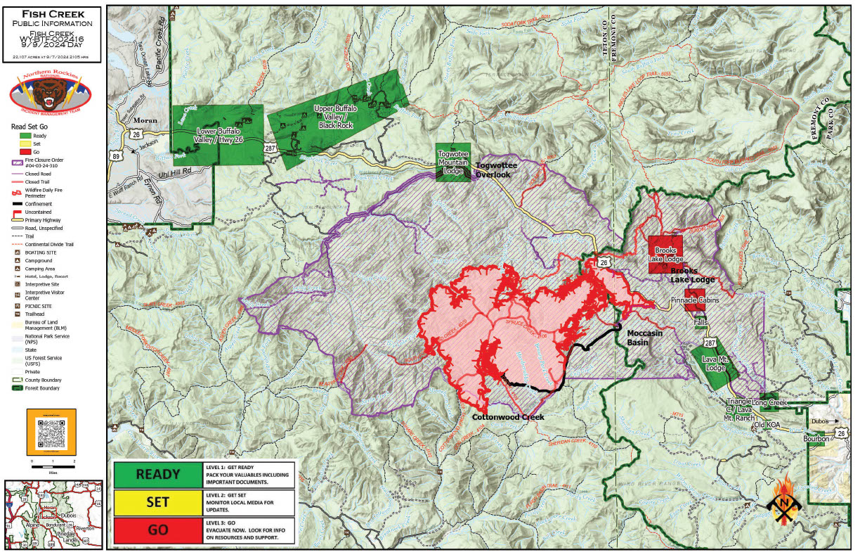
Fish Creek Fire Update Monday 09 09 2024
Related Incident:
Publication Type: News
Northern Rockies Team 2, Incident Commander Scott Schuster
Location: 7 miles SW of Togwotee Pass
Start Date: Friday, August 16, 2024
Cause: Lightning
Size: 23,911 acres
Percent complete: 69%
Resources: 460 Total Personnel: 7 Hand Crews; 20 Engines; 20 Heavy Equipment; 4 Helicopters
KEY MESSAGES:
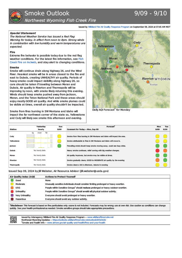
The National Weather Service (NWS) has issued a RED FLAG WARNING for the fire area from noon until 8:00 p.m. today. A red flag warning indicates that conditions are conducive for wildland fire growth and rapid spread.
As of Sunday evening, U.S. Highway 26/287 is open for free-flowing traffic in both directions. Since this remains a high priority area, there will be a continued large presence of fire personnel and fire vehicles in that corridor and the maximum speed has been reduced to 45 mph. For everyone’s safety, we ask all motorists to please slow down, stay alert and proceed with caution through the fire area.
CURRENT STATUS:
The western edge of the fire is burning towards and into some meadows which is slowing the growth of the fire on that side. On other sections of the fire perimeter, the fire is burning into the footprint of prior fires where there is less fuel, which is also limiting the growth of the fire in those areas. The most active part of the fire is in the Cottonwood Creek area. The fire is burning in standing, beetle-killed conifers and downed, dry trees and logs. This active fire behavior is creating the large columns of smoke that can be viewed from miles away.
Overnight, resources monitored the fire activity and patrolled the Highway 26 corridor and the 537 road. Today’s resources will further monitor and secure the Highway 26 corridor, and structure-protection resources will continue to test sprinkler systems and hose around the Brooks Lake Lodge and Pinnacle residences. Air resources will monitor the fire activity particularly in the southern portion of the fire and provide bucket work and air support.
WEATHER AND FIRE BEHAVIOR:
The combination of warmer temperatures, lower humidities, and stronger winds have prompted the National Weather Service to issue a Red Flag Warning for today. Those same conditions are expected to increase the amount of visible smoke and fire behavior, especially single tree torching and spot fires. Wind gusts of 25 to 35 mph are expected throughout the afternoon and into the early evening hours.
AIR QUALITY AND SMOKE:
Increased fire activity often correlates to an increase in smoke and a decrease in air quality. This is of special concern for older adults, individuals with respiratory issues and young children. Residents should monitor the Air Quality Index (AQI) for their specific area and take mitigating actions to reduce or limit their exposure to smokey air when the AQI is elevated.
Air quality alerts, current and predicted smoke conditions and helpful FAQ’s can be found on the AirNow website at https://www.airnow.gov/.
CLOSURES AND EVACUATIONS:
The joint Closure Order issued by both the Bridger-Teton and Shoshone National Forests for the fire area, remains in effect. Please do not enter the closure area or use any Forest Roads that are closed. For specific details regarding this closure, please reference the Fish Creek Area, Roads, and Trails Closure Order (map) and the Forest website at https://www.fs.usda.gov/alerts/btnf/alerts-notices.
Under the jurisdiction of Fremont County, the areas of Brooks Lake, Pinnacle Drive and Breccia Drive remain under a Level 3 Evacuation notice (Indicated by red blocks on the PIO Incident Map). A Level 3 Evacuation means “Go” to evacuate. Residents must remain evacuated until advised otherwise by Fremont County. See the alert notice on the Fremont County Fire Protection District Facebook page.
The Teton County Division of Emergency Management utilizes a Ready, Set, Go system for evacuation messaging, visit their website for additional details at www.tetoncountywy.gov/1846/Ready-Set-GO. (Indicated by green blocks on the PIO Incident Map.) They advise all residents to be in a “Ready” status by preparing for evacuations and becoming fire adapted.
US HWY 26/287 continues to experience smoke and sometimes limited visibility. Wyoming Department of Transportation (WYDOT) is working closely with Fremont County Emergency Management and fire officials for the safety of motorists and firefighters. Drivers are encouraged to visit https://www.wyoroad.info/ prior to traveling on US HWY 26/287 for road status and information, or download the Wyoming 511 app at https://www.wyoroad.info/511/WY511Mobile.html to monitor for any changes due to fire activity.
West and Preacher Fires Update 09 09 2024
Related Incident: 2024 - West Fire - TNF2024 - Preacher Fire - TNF
Publication Type: News
Ignitions planned to begin today
Highlights/Operations: Ignitions began yesterday on both the West and Preacher Fires. On the West Fire, south-facing slopes and areas exposed to sun and wind were receptive to ignitions, which began in the West Webber Creek drainage. Mastication of fuels along the Control Road just north of Geronimo Estates continued. On Preacher, the Control Road near Tonto Village was still not dry enough to carry fire, so crews began lighting from the active fire’s edge along the Diamond Point Road and headed south towards Diamond Point. Engines worked across all the communities to finish installing hoses and testing them as part of the structure protection plan.
Today on the West Fire, aerial and hand ignitions will continue where they left off yesterday in East Webber Creek Drainage and begin on the top of the Rim off the 300 road. On Preacher, the area south of Tonto Village will be reassessed for ignitions. If it still isn’t dry enough, crews will move back over to the Diamond Point Road to pick up where they left off yesterday.
Across the rest of the area on both fires crews, engines and equipment are improving containment lines, testing structure protection equipment like hoses and sprinklers and removing any remaining fuels necessary. A night shift is patrolling in communities to ensure private property and structures are protected around the clock.
Weather: A few showers may develop on the Mogollon Rim Monday afternoon but are not expected to reach the Preacher fire. Otherwise, the week will be seasonably warm, dry and rain-free. Southwest winds will increase by mid-week with frequent afternoon gusts over 25 mph.
Safety: Two Temporary Flight Restrictions (TFR) are now in place over the area, which includes uncrewed aircraft systems or drones. Reminder that if you fly we can’t, unauthorized drone flights pose serious risks to firefighter and public safety and the effectiveness of wildfire suppression operations.
Closure: The Tonto National Forest has issued a closure for land surrounding the West Fire, this includes Pine Trailhead. https://inciweb.wildfire.gov/incident-publication/aztnf-2024-west-fire-tnf/us-forest-service-closure-order-for-west-fire-09-04-2024
Evacuations: Some residents east of Payson near the Preacher Fire have been moved to the SET level. An interactive map is available to stay up to date with evacuation levels related to both the West and Preacher Fires.
https://nifc.maps.arcgis.com/apps/instant/sidebar/index.html?appid=9bf2ca222ee74f8697bc670ae9c2531a
Smoke: During ignitions, smoke may settle in low-lying areas overnight. Residents are encouraged to close windows at night to avoid smoke impacts. Talk with your doctor and plan for how to manage your health conditions when it is smoky. Additional resources for how to prepare for wildfire smoke can be found at https://www.airnow.gov/wildfire-guide-factsheets/
For the latest news and information about the Tonto National Forest, follow along on Facebook @TontoNationalForest, ‘X’ (formerly Twitter) @TontoForest or Instagram @tontonationalforest and on the Tonto National Forest website: https://www.fs.usda.gov/tonto