
Incident Publication
Bridge Fire Morning Update 09 09 2024
Related Incident: Bridge Fire
Publication Type: News
Bridge Fire Morning Update: September 9, 2024
Bridge Fire Quick Facts:
- Acres: 1,255
- Crews: 7
- Containment: 0%
- Engines: 21
- Start Date: September 8, 2024 | 2:40 p.m.
- Dozers: 2
- Cause: Under investigation
- Helicopters: 4
- Total Resources: 250
- Fixed-wing Aircraft: 4
- Fire Information Center: (626) 662-0120 | Hours: 8:00 a.m. to 8:00 p.m.
Current Situation: On Sunday, Sept. 8, at 2:40 p.m., Angeles National Forest firefighters responded to a reported wildfire in the San Gabriel Mountains National Monument in the East Fork area by Cattle Canyon Bridge along Camp Bonita Road. The fire is currently an estimated 1,255 acres with 0% containment. Crews continue to aggressively attack the fire with air and ground resources.
Overnight, the fire behavior was extremely active, moving south to Glendora Mountain Road. The fire is being held on the west end at Shoemaker Road. Today firefighters will continue to focus heavily on structural protection of the communities in the East Fork and preventing further fire spread to the south. Multiple agencies, including the Los Angeles County Fire Department, California Highway Patrol, and Los Angeles County Sheriff's Department, are assisting in fighting this wildfire.
To stay up-to-date with current wildfire information, follow the Angeles National Forest:
- InciWeb: https://inciweb.wildfire.gov/incident-information/caanf-bridge-fire
- Facebook: https://www.facebook.com/angelesnationalforest
- X (formally known as Twitter): https://x.com/Angeles_NF
- Website: fs.usda.gov/angeles
Evacuations: East Fork communities of Camp Williams Resort (café, mobile home park, campground) and River Community (near the resort).
- Evacuation Center (American Red Cross): For more information, call 1-800-733-2767 | Hours: 24-hours
Location: Hacienda Heights Community Center, 1234 Valencia Ave., Hacienda Heights, CA 91745
Closures:
- San Gabriel Canyon and the East Fork of the San Gabriel River remains closed to all forest visitors.
- Highway 39
- East Fork Road
- Glendora Ridge Road
- Glendora Mountain Road
Weather and Fire Behavior: The National Weather Service has issued an excessive heat warning until 8:00 p.m. Hot and dry gusty conditions are expected to influence active fire behavior creating control challenges and a high-growth potential.
Fire Restrictions: The current fire danger level on Angeles National Forest is HIGH. "Know Before You Go" – always check fire restrictions before each and every visit, as restrictions can change at any time with little to no notice:
https://www.fs.usda.gov/detail/angeles/home/?cid=FSBDEV3_02772
Line Fire Daily Update for 09 09 2024
Related Incident: Line Fire
Publication Type: News
Line Fire Daily Update,
Fire activity on the Line Fire was moderated in the upper elevations in the overnight hours but remained active in the thermal belts.The fire made short, intense runs in the slopes and the lighter fuels which allowed for growth. Vegetation remains critically dry. Hotand dry weather will continue Monday with an Excessive Heat Warning for the lower elevations of the fire. There will be areas ofsmoke in the morning that could become more widespread in the afternoon. There is also a chance of showers and a slight chanceof thunderstorms in the late morning and through the early evening.
There are currently 36,328 structures that are still threatened.
Governor Newsom has proclaimed a State of Emergency in SanBernardino County, securing federal assistance to support response to the Line Fire.
A Damage Inspection Team (DINS) has been ordered. There are currently 1,708 personnel assigned to the fire.
For information on the Line Fire, please call (909) 220-4292.
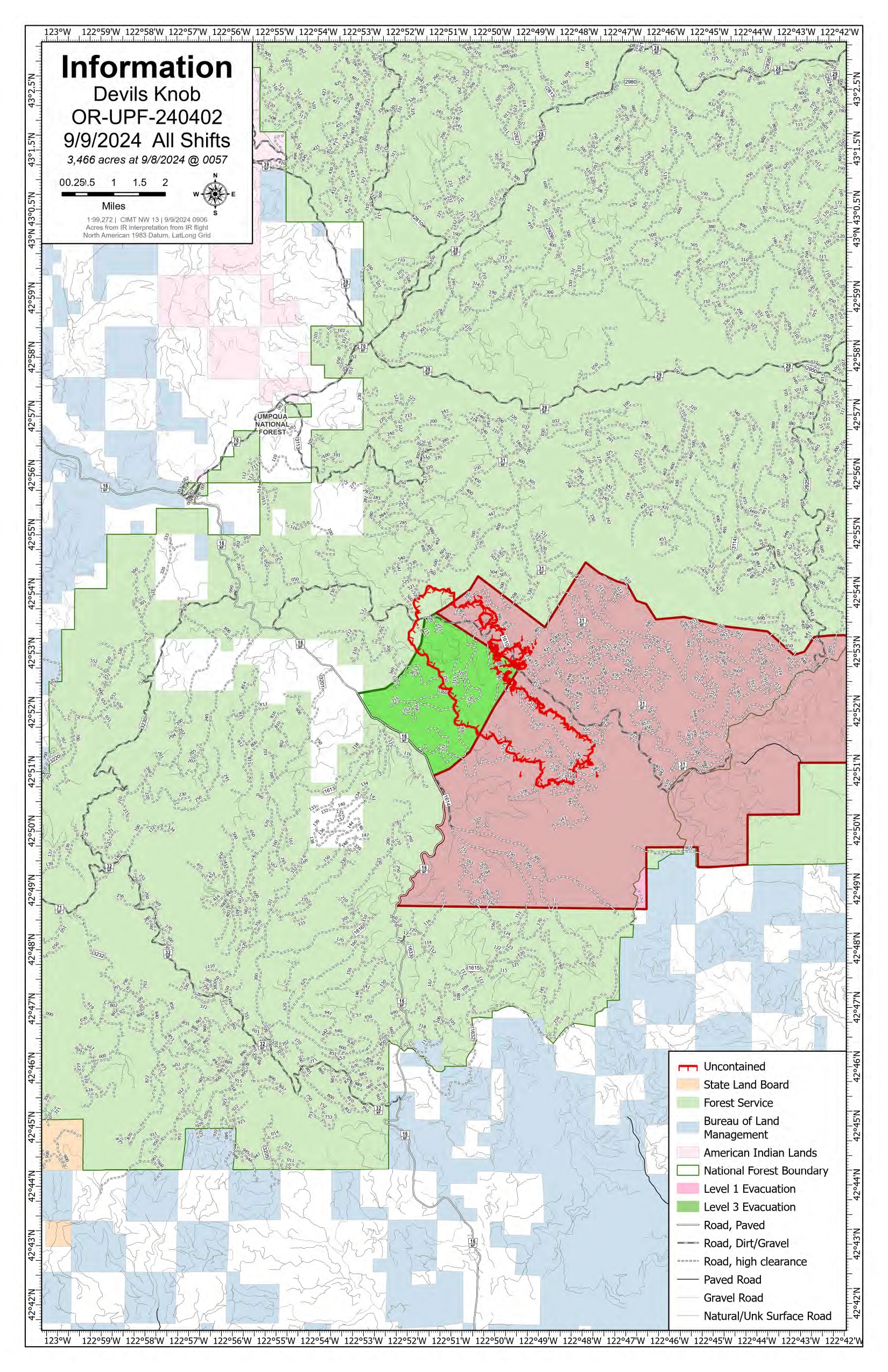
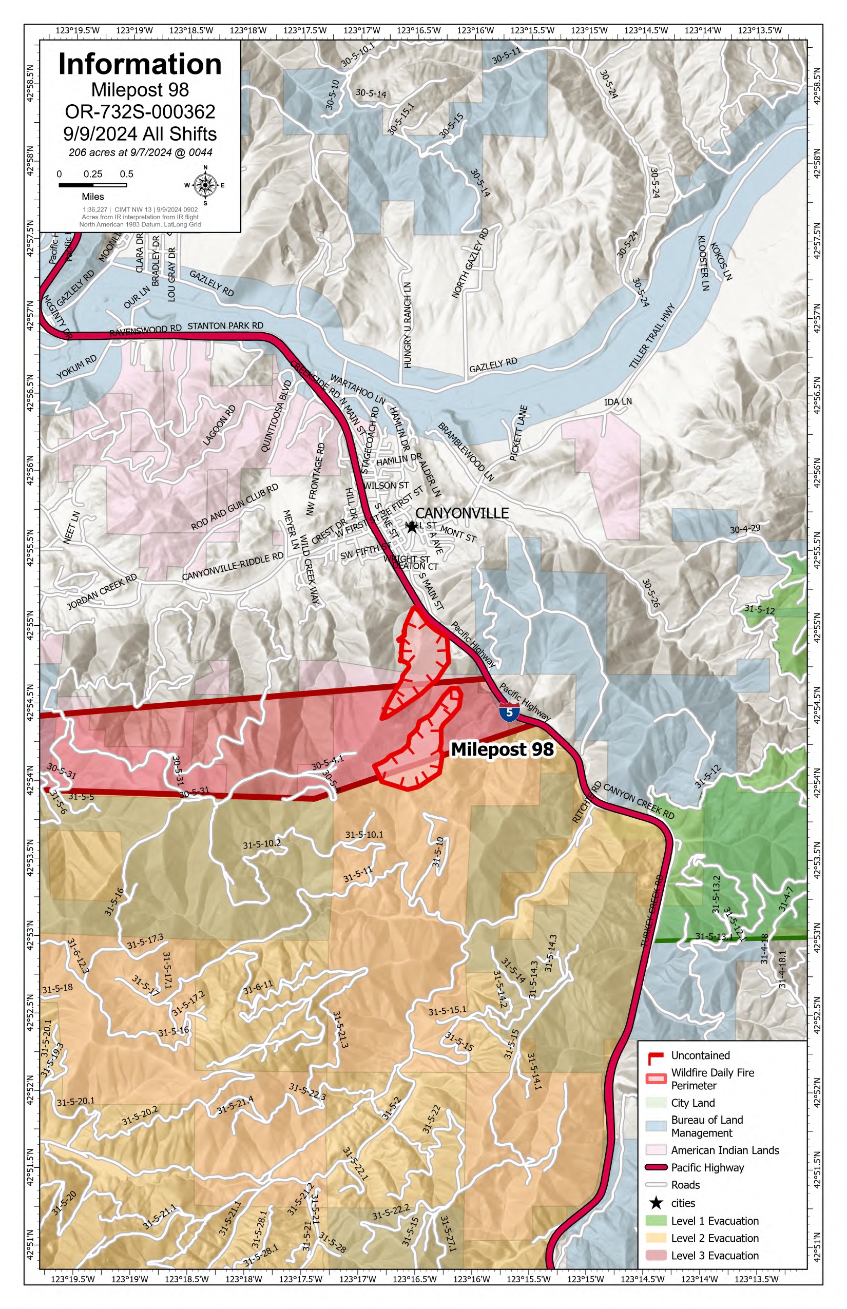
Devils Knob and Milepost 98 Daily Update 09 09 2024
Related Incident:
Publication Type: News
Devil’s Knob and Milepost 98 Fires Update for Monday, September 9, 2024
KEY MESSAGES:
Delays are expected along the Interstate-5 corridor as fire suppression efforts occur on Milepost 98 Fire. For updated travel information, please visit https://www.tripcheck.com/.
CURRENT STATUS:
Local units, including Tiller and Milo Rural Fire Protection District personnel, are working with the CIMT NW 13 to protect structures near the Devil’s Knob and MP98 fire perimeters.
Devil’s Knob
The high heat and low relative humidity led to active burning conditions on the Devil’s Knob Fire. Firefighters are establishing anchor points in which to build hand and dozerline to secure priority areas along the fire perimeter protecting values at risk. A thermal trough is expected tomorrow which will increase fire behavior as heat increases in low elevations.
Milepost 98
Firefighters, working on the spot fire established on Saturday, have successfully built line around its ½ acre perimeter. Resources were engaged in mop-up operations where successful tactical firing operations were completed from previous operational shifts. Firefighters are also plumbing portions of the perimeter to deliver a steady water supply to aid in minimizing the progression of the fire.
WEATHER / FIRE BEHAVIOR:
Mostly sunny skies will continue over the fire area today with a maximum temperature of 83. Relative humidity levels will remain low as the warming and drying trend continues through the day. Wind will be light, with gusts up to 12 miles per hour. This weather pattern may produce fire growth but less rapidly than in previous days.
SAFETY AND CLOSURES:
Closures on the Umpqua National Forest can be found at https://www.fs.usda.gov/alerts/umpqua/alerts-notices. These alerts show the official closure orders with listed roads and trailheads, as well as maps of the closed areas.
Multiple evacuations have been established in the fire area. These evacuations are coordinated by the Douglas County Sheriff’s Office. An interactive map can be found at their website, https://www.dcso.com/EVACUATIONS. Residents are encouraged to sign up for emergency notifications through Douglas County Emergency Management, found at https:// www.dcso.com/254/Emergency-Notification-System. The Red Cross has pre-positioned supplies in Days Creek if a shelter is needed. Staff and volunteers remain available for activation where requested.
Middle Fork Complex Operational Video Update for Monday 09 09 2024
Related Incident:
Publication Type: Announcement
The Middle Fork Complex Fire operational video update for Monday, September 9, 2024 with the Operations Section Chief, Great Basin Incident Management Team 5 can be viewed here: https://youtu.be/1Tf5_ZuGRHY?feature=shared
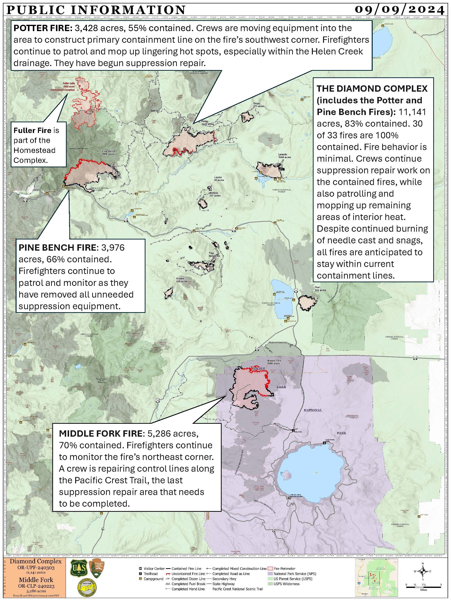
Diamond Complex and Middle Fork Fire Update for September 910 2024 09 09 2024
Related Incident: Middle Fork Fire
Publication Type: News
Diamond Complex
- Size: 11,141 acres
- Containment: 83%
- Personnel: 806
- Location: 18 miles SW of Chemult, OR
- Start Date: July 19, 2024
- Cause: Undetermined
Middle Fork Fire
- Size: 5,286 acres
- Containment: 70%
- Personnel: 29
- Location: Crater Lake National Park
- Start Date: July 17, 2024
- Cause: Undetermined
Visitor and Firefighter Safety, and Fire Restrictions
For everyone’s safety, please slow down and drive carefully near firefighter activity.
CLOSED AREAS: Area, road and trail closures remain in place. Do not enter closed areas or drive around barriers. Entire roadways may not be blocked to allow firefighter traffic. Areas are closed due to dangerous conditions like falling trees, heavy equipment and road grading.
Current Fire Situation
The Diamond Complex includes 33 fires in the Umpqua National Forest, 30 of which are 100% contained. Firefighters suppressed a new 0.2-acre fire discovered on Friday. Cooler temperatures and more moisture in the atmosphere are keeping fire behavior minimal. Crews continue suppression repair work on the contained fires, while also patrolling and mopping up remaining areas of interior heat. Despite continued burning of needle cast and snags, all fires are anticipated to stay within current containment lines.
Middle Fork Fire
Firefighters continue to monitor the fire’s northeast corner. A crew is repairing control lines along the Pacific Crest Trail, the last suppression repair area that needs to be completed.
Diamond Complex
- Pine Bench Fire (north of Hwy. 138 near Dry Creek, 3,976 acres, 66% contained): Firefighters continue to patrol as they have removed all unneeded suppression equipment.
- Potter Fire (north of Hwy. 138, 2 miles southeast of Potter Mountain, 3,428 acres, 55% contained): Crews continue to construct primary containment line on the fire’s southwest corner using heavy equipment. Firefighters continue to patrol and mop up lingering hot spots in the fire’s interior, especially within the Helen Creek drainage. They also are removing unneeded equipment and continuing suppression repair.
Weather and Fire Behavior
Fire behavior is predicted to be minimal as cooler temperatures and higher humidities move into the area. The trend of moderating weather continues on Monday with temperatures in the mid-70s and relative humidity close to 30%. Tuesday will be cooler with highs in the 60s and minimum relative humidity 40%. There is a 70% chance of a wetting rain on Wednesday and high temperatures in the 50s. Rain may continue Thursday morning with a high of 60 degrees.
Smoke Outlook
Smoke from the Diamond Complex and Middle Fork Fires is minimal. However, winds may push smoke from nearby fires into the area causing air quality to be moderate. For more information, visit www.fire.airnow.gov.
Forest Closure and Fire Restrictions
Umpqua National Forest’s current closure order allows access to specific roads, trails and campgrounds, which are listed as exemptions in Forest Order 06-15-24-07. Umpqua National Forest has decreased Public Use Restrictions to Level 2. The forest remains in High Fire Danger and Industrial Fire Precaution Levels are at Level 2. For more information, visit https://www.fs.usda.gov/alerts/umpqua/alerts-notices/?aid=88996.
A closure is in place on Rogue River-Siskiyou National Forest for the area north and west of Crater Lake National Park along Hwy. 230 south to the intersection with Hwy. 62. The current closure order, map and fire restrictions are available at https://www.fs.usda.gov/alerts/rogue-siskiyou/alerts-notices.
Park Closure and Fire Restrictions
Crater Lake National Park is open. However, several trail closures are in effect. For details, visit https://www.nps.gov/crla/planyourvisit/conditions.htm.
Know before you go. Check the latest conditions and road status to ensure a smooth, enjoyable visit. Updates are available on Oregon Tripcheck at https://www.tripcheck.com.
Temporary flight restrictions (TFRs)
A TFR is in place over the Potter and Pine Bench Fires from 9 a.m. to 8 p.m. local time. A map is available at https://tfr.faa.gov/save_pages/detail_4_7055.html. Remember, if you fly, we can’t.
Coffee Pot Daily Update 09 09 2024
Related Incident: Coffee Pot Fire
Publication Type: News
CURRENT SITUATION: Air operations played a key role in yesterday's efforts; fixed and rotor-wing aircraft dropped retardant from Horse Creek to the East Fork Kaweah River, delivered equipment to spiked-out crews, and continued strategic bucket drops on the northeast portion of the fire. Water tenders applied retardant along Mineral King Road, east of Horse Creek, and Wildland Fire Modules (WFM) constructed direct handlines near Homers Nose. Crews focused on backhauling equipment, addressing hazardous trees, and mopping up deeper into the fire line along the southern and western flanks.
Today, crews will continue constructing indirect handlines from Mineral King Road to the East Fork Kaweah River, using firing operations as necessary to produce a slow-moving, low-intensity fire. Construction of the indirect handline from the head of Eden Creek drainage will progress north toward Horse Creek. Air operations will provide support as needed, including water drops and retardant application.
Rehabilitation and hazardous tree removals are ongoing along Salt Creek Road and Case Mountain Road.
WEATHER: High pressure will continue to weaken through Tuesday, bringing slightly cooler temperatures. Winds will remain mostly from the southwest, with upslope and up-canyon winds developing later in the morning. Smoke conditions should improve as the inversion lifts midday. Overnight, drainage winds are expected along the East Fork of the Kaweah River.
SMOKE IMPACTS: Smoke has greatly diminished throughout the outlook area. Areas closest to the fire; Three Rivers, Hammond, and Giant Forest continue to see smoke impacts, with air quality in the MODERATE range. Areas to the North and South of the fire can expect GOOD air quality. For more information on current wildfire smoke impacts in your community, please visit AirNow.gov or fire.airnow.gov.
EVACUATION NOTICES: The Tulare County Sheriff’s Office has issued Evacuation ORDERS due to current fire conditions for Genasys zones TLC-E094-C, TLC-E094-E, TLC-E094-D, and TLC-E094-B. An evacuation ORDER, also known as a mandatory evacuation, means that all residents and visitors should leave now before the fire reaches the community. If you are unable to evacuate and require assistance, please call 9-1-1. In case of sheltering needs or questions regarding sheltering, please contact the American Red Cross at 1-800-733-2767.
The Tulare County Fire Department has also issued Evacuation WARNINGS for zones TLC-E093-A, TLC-E093-B, TLC-E095, and TLC-E128-A. To find your zone, please refer to: protect.genasys.com
FIRE INFORMATION: A Public Information Officer will be at the Three Rivers Village Market daily from 10:30 a.m. to 4 p.m. to provide fire information and answer questions.
BLM AND PARK CLOSURES: The portion of South Fork Drive within Sequoia and Kings Canyon National Parks and trails accessed from the road, including the Ladybug and Garfield Grove Trails, are closed. Recreational access to the Mineral King area of Sequoia National Park is closed to the public. This applies to Mineral King campgrounds, trailheads, and area trails. All other areas of the parks are open but are likely to be impacted by varying levels of smoke and poor air quality. Park closure information is available online at nps.gov/seki. The Bureau of Land Management has also issued a closure of the Case Mountain Extensive Recreation Management Area at blm.gov/press-release.
PUBLIC NOTICE: Wildfires are a no-fly zone for unauthorized aircraft, including drones. If you fly, we can’t. For more information, visit knowbeforeyoufly.org.
Monday September 9 2024 RailroadDaly Update and Map 09 09 2024
Related Incident:
Publication Type: News
Northern Rockies Team 5, Incident Commander Joe Sampson
Location: Railroad Creek/ Skalkaho Creek confluence, 26 miles southeast of Hamilton
Start Date: 7/25/2024 Cause: Undetermined
Daly Fire Acres: 2,170 Completion: 6%
Railroad Fire Acres: 490 Completion: 4%
Total Personnel: 33
CURRENT STATUS
Northern Rockies Complex Incident Management Team 5, led by Incident Commander Joe Sampson, took command of the Railroad-Daly Fires at 6 a.m. today. The Daly Fire is currently advancing to the northeast towards Skalkaho Pass, with significant movement overnight due to gusty outflow winds (acreage will updated with the next mapping flight). The fire has crossed north of Highway 38 on its northwest flank east of Gird Point. The fire will also advance into previous years’ fire footprints as it progresses northward. Both fires have reached the fire footprint from last year’s Bowles Creek Fire. Crews will continue to remove hazardous trees along the south side of Highway 38 to mitigate safety concerns for firefighters and members of the public when the highway reopens. Crews will also utilize previously constructed control lines in the Skalkaho Creek drainage.
WEATHER AND FIRE BEHAVIOR
Thunderstorms passed through the fire area last night, bringing wind gusts up to about 30 mph. However, the fire area did not receive any measurable precipitation. Today, hot and dry conditions are expected with southwest wind gusts reaching about 20 mph along the ridgetops. Temperatures will likely remain in the mid-70s, with relative humidities in the mid-20s. The majority of the fire’s movement will be in the upper slopes where dry, subalpine fir has the potential to torch and cause short-range spotting up to ½ mile.
In the coming days, precipitation is expected with up to 1 inch of rain possible in the fire area. This wetting rain will likely hinder the fire’s ability to move substantially for a week or so or until fuels along the fire’s perimeter dry out. However, thunderstorms could potentially cause new fire starts.
EVACUATIONS, RESTRICTIONS, CLOSURES
There are no evacuation warnings in place currently. The Skalkaho Highway (Highway 38) is closed from Black Bear Campground to the top of Skalkaho Pass. Gird Point Lookout is also closed. The Anaconda-Pintler Wilderness in the Bitterroot National Forest is currently in Stage I Fire restrictions.
Actualizacin del incendio Whisky Creek Sandstone y Blister Creek 09 09 2024
Related Incident: Whisky Creek FireSandstone Fire
Publication Type: News
Tamaño de Whisky Creek: 2,935 acres | Fecha de inicio: 20 de julio |Causa: De orígen humano |Contención 25%
Tamaño de Sandstone : 702 acres | Fecha de inicio: 5 de agosto | Causa: Rayo | Contención 75%
Total de recursos: 306 | Equipos de obreros: 4 | Camiones de bomberos: 7 | Topadoras: 2 | Maquinarias pesadas: 11 | Helicópteros: 3
Los incendios Whisky Creek, Sandstone y Blister Creek arden en un terreno escarpado y escabroso en el Bosque Nacional Mt. Hood, donde los escombros rodantes y los árboles que han sido debilitados por el fuego dificultan el trabajo de extinción. Los recursos de incendios permanecen listos para ayudar con cualquier fuego nuevo que comience por si es necesario.
Whisky Creek: El incendio tuvo mayor actividad cerca de las aguas cabeceras de Herman Creek y ayer el fuego se desplazó un poco en la ladera suroeste. Un pequeño fuego salpicado ardió debajo de la meseta de Benson, pero parece que se esté desplazando o creciendo. Los bomberos removieron las envolturas que protegen las estructuras y letreros y que no siguen bajo amenaza de incendio. Mediante un vuelo de reconocimiento, los bomberos exploraron el extremo norte del incendio buscando sitios secundarios para cortafuegos. Helicópteros grandes y medianos asignados al incidente siguen apoyando en el incendio Williams Mine ubicado en Washington, al verter unos 38,000 galones de agua sobre ese incendio ayer.
Las cuadrillas continuarán patrullando y observando el incendio tanto desde el aire como desde abajo. Los encargados del incendio están trabajando en un plan de quema de contingencia que podría ponerse en efecto en el futuro, si llega a ser necesario. Hoy, los bomberos están conectando la última pieza de una sección de mangueras para ampliarla al noreste del lago Wahtum. Este tendido de mangueras se pondrá bajo prueba completamente para asegurarse de que esté listo si es necesario. Las topadoras y excavadoras continuarán reparando las líneas de las topadoras y la nivelación de carreteras en la carretera del Servicio Forestal (FSR) 2810.
Sandstone y Blister Creek: Señas de calor aislado persisten en el mapeo infrarrojo de los incendios Sandstone y Blister Creek, pero no se ven indicaciones de humo. Las maquinarias pesadas terminaron de reparar la línea de topadoras al sur de los incendios. Se continúa la reparación por extinción de incendios mientras las excavadoras trabajan en las FSR 7015 y 6320.
Clima: Se prevén condiciones climáticas más frescas y húmedas con un pronóstico de lluvia para el martes por la noche que durará hasta el miércoles. La calidad del aire sigue afectada por numerosos incendios grandes en el centro y sur de Oregón. Para pronósticos de humo y seguridad, consulte: oregonsmoke.org.
Cierres: Los cierres de áreas permanecerán en el Bosque Nacional Mt. Hood, el Área Escénica Nacional Columbia River Gorge y el Condado de Hood River. Se establecen cierres para la seguridad del público y de los bomberos; La intrusión en un área de cierre puede interrumpir las actividades de extinción y reparación de incendios, poner en peligro vidas y propiedades, y puede resultar en multas. La información de cierre se encuentra en: https://linktr.ee/whisky_creek.2024.
Seguridad: El público juega un papel importante en la prevención del próximo incendio forestal; tenga cuidado con cualquier posible fuente de incendio. Para obtener consejos de prevención, consulte: https://keeporegongreen.org. La TFR sigue vigente para ambos incendios: https://bit.ly/3T59VWv. Las restricciones contra incendios están vigentes dentro del Bosque Nacional Mt. Hood. Se puede ver más información en: https://www.fs.usda.gov/main/mthood/fire.
West Mountain Fires Daily Update 09 09 2024
Related Incident: Boulder FireDollar Fire
Publication Type: News
September 9, 2024 - West Mountain Fires Update
Quick Facts *The acreages do not reflect the growth from yesterday. Firefighters are ground truthing mapping data. When we get an acurate map, we will share it.
#boulderfire 6 miles SW of Cascade 4,159 24% https://tinyurl.com/ycdfv3tv
#snagfire 11 miles E of Cascade 33,014 13% https://tinyurl.com/4k9dk3mu
#Dollarfire 18 NE of Cascade 4,297 8% https://tinyurl.com/bef6r3tz
#goatfire 11 miles SE of Cascade 6,054 0% https://tinyurl.com/2h4a3dvr
Cause: Lighting (All Fires) Total Incident Personnel 1096
Special Note: There will be a COMMUNITY MEETING tomorrow, TUESDAY, September 10, 7pm, at the Cascade Fire Department, 109 E. Pine St., Cascade. Operations and evacuation information will be shared.
EVACUATIONS: A significant increase in fire behavior prompted GO evacuations in Zones 4 and 5 yesterday as well as an upgrade to SET in Zones 6, 7. For more, check Valley County Sheriff’s Office Facebook or call dispatch at 208-382-5160.
Weather and Fire Behavior:
Today, Monday, will be another warm, dry, and windy day with temps up to the low 80s and humidity in teens to low 20s. Winds predicted from the SW at 6-10 mph, and 15-20 mph near the ridgetops. While atmospheric instability should be slightly improved over yesterday’s conditions, fire is still expected to be active to very active today. Fuels remain dry and receptive to burning; group torching, uphill runs, spotting, and short crown runs are all possible. The behavior of the neighboring Lava Fire could significantly impact the Boulder and Goat Fires; any column collapse could send outflow winds as well as contribute to significant spotting. Tuesday is expected to be even more active with comparable behavior to what was seen yesterday. Wednesday through Friday there is a greater chance of rain over the fire areas.
Boulder Fire: “Go,” “Set,” and “Ready” evacuation orders are in effect. Learn more: Valley County Sheriff on Facebook.
- The Boulder Fire was very active yesterday, generating spots and running through a stretch of timber toward Collier Peak where it slowed in the sub-alpine fuels. While this area of fuel is not as receptive to burning compared to lower elevations, columns generating spots that travel to the north/northwest are of significant concern, as is impact of columns from the neighboring Lava Fire.
- The neighboring Lava fire made a significant push north and east, hooking around the Four Corners burn scar. Fire managers are assessing the proximity of the Lava Fire to the Cascade area and will have more info later today.
- Firefighters are utilizing dozer and handlines along the Le John, Mosier, and 404 roads system as holding features. If conditions allow, firefighters may perform strategic burning operations to the west of these roads to help protect homes north of the fire. The fire remains west and south of the 404 roads and the dozer line below the structures.
Dollar Fire:
- The Dollar Fire is showing very little activity, with the northern edge/Square Top remaining the area of focus. Today, this fire will be placed in “monitor” status and be monitored by air. The Black Hills Wildland Fire Module will be relocated today so their specialized skills can be utilized for operations on the Boulder Fire.
Snag Fire:
- Warm Lake Road closed to the public. A pilot car access to residents will continue from 7 am – 6 pm.
- The east side is holding in the old burn scars, and structure protection continues near the Fish Hatchery and the values in this area. Masticators are working along the 474 Road. Chipping is taking place along Road 409.
Goat Fire:
- The fire made a significant push to the west and crossed the 099 Road, burning up the 417 Road. Fire is moving laterally to the NE, looping around the old Skunk and East burn scars.
- Firefighters are prepping the 409 Road as a holding feature and may perform burning operations as needed.
Red Fire Daily Update 09 09 2024
Related Incident: Red Fire
Publication Type: News
Activities – Yesterday, the Red Fire grew 78 acres mostly to the north towards Redtop Mountain. The fire continues to back downslope into the vicinity of the Whitefish Creek Trail. Today, firefighters will continue to monitor and secure the area. Crews will haul chips out of the completed shaded fuel breaks and rehabilitation work continues along Forest Service Road 60. Structure protection equipment remains in place along Crescent Lake. Today, firefighters will test pumps and check on this equipment. At 7 a.m. Tuesday morning, management of the Red Fire will transition to the Willamette Complex-South’s NW Team 2 incident management team to better align strategies and support for the 208 and Red Fires.
Strategy – A full suppression strategy is being implemented utilizing indirect tactics, shaded fuel breaks, structure protection equipment, trails, and hose lays. When the fire started, an assessment by the initial attack incident commander, local fire managers and forest staff determined the risk to responders was too great to continue with direct attack due to a lack of escape routes and safety zones, snag hazards, and firefighter safety issues in the remote location. Firefighters are continually reevaluating the safest, most effective suppression strategy based on changing weather, fuel conditions, and fire behavior. Firefighter and public safety remain the highest priority in managing this fire.
Closures – To provide for the safety of firefighters, equipment operators, and the public, the Deschutes National Forest emergency closure around Crescent Lake and in the Diamond Peak Wilderness is still in effect. Forest Service Road 60 is closed, and road guards have been posted for public safety. The emergency closure is being reevaluated daily as conditions continue to change. More closure information is available at: https://www.fs.usda.gov/alerts/deschutes/alerts-notices/?aid=89091.
The Pacific Crest Trail (PCT) is closed from north of Windigo Pass (Mile 1883.5) to Highway 58 (Mile 1909.5). The previous PCT detour around the fire has been decommissioned as of noon on September 4. Currently there is not a detour around the closure. A map displaying the PCT closure can be viewed on the Pacific Crest Trail Association’s (PCTA) website at: https://closures.pcta.org/closure/Mr02blDvEwX1SJ9h1H49.
The 2024 season for commercially harvesting Matsutake mushrooms opened for the Deschutes National Forest is open and will close November 4, 2024. The emergency fire closure impacts certain harvesting locations.
Incident Weather, Fire Behavior, and Smoke –Today will be cooler with temperatures reaching 70-75 degrees but still hot and dry. Increased fire activity is expected. Tomorrow begins a cooling trend and with highs dropping into the 60s and higher relative humidity. There is an 80% chance of precipitation over the fire on Wednesday with possible thunderstorms.
Evacuations – The WILDFIRE! Level 1 – BE READY to Evacuate notice issued by Klamath County Emergency Management for Crescent Lake, Odell Lake, and Crescent Junction areas remains in effect (INCENDIO FORESTAL! Nivel 1 - ESTÉ PREPARADO para evacuar de las siguientes zonas: Crescent Lake, Odell Lake, Crescent Junction). Visit www.klamathcounty.org/300/emergency-management for more information or to sign up for alerts.
Fire Restrictions – Stage 2 Public Use Fire Restrictions – which prohibit open fires, including in developed campgrounds – remain in effect for the Deschutes National Forest. The Industrial Fire Precaution Level is currently Level III “Partial Shutdown.” Visit fs.usda.gov/detail/deschutes/home/?cid=stelprdb5297376 for more information.