
Incident Publication
Huckleberry Ridge Fire Update 09 08 2024
Related Incident:
Publication Type: News
Huckleberry Ridge Fire
Daily Update
September 8, 2024
Reported: September 4th at 3:45 p.m. | Size: 293 acres | Cause: Under investigation
Total Personnel: 294| Engines/Tenders:27 | Hand Crews:11
Safety: Hunting season has started, and many people are out in the woods. Please be aware there are both firefighters and hunters in the woods right now. Use caution and stay vigilant. For anyone hunting, please stay out of the fire area and be aware there is substantial firefighting activity in the area with a lot of vehicle traffic.
Update: The Huckleberry Ridge Fire is burning eight miles from the nearest structure and eleven miles from the nearest community. No infrastructure is at risk at this time. Crews worked the fire overnight with minimal fire growth. Total acreage has decreased almost 50 acres due to more accurate mapping of burned areas by ground resources.
As more crew and equipment arrive we will continue to add more handlines and more dozer lines boxing in the fire. The cooler weather overnight and lack of significant winds have helped with fire management. Crews are safely able to engage the fire in a more direct fashion. Due to the network of roadways throughout the fire area, crews were able to create about 40% of the containment lines using existing roads and trails. We will continue to use air resources as the weather cooperates including aerial views for more accurate mapping.
Evacuations: There are no anticipated evacuations in the future for this fire, but we continue to ask that the community stay out of the area of the fire, be alert, and stay aware of the danger that exists in your area.
Closures: No road or trail closures.
Weather: Today we will see much of the same weather as yesterday but slightly cooler. Expect some fog and hazy clouds in the area this morning with sunshine peeking through later this afternoon. Temperatures may reach into the mid-70’s today with some light winds.
Air Space Restrictions: A Temporary Flight Restriction (TFR) is in place over the fire. If you fly, we can’t.
Malheur National Forest UPDATED closure September 8 2024 09 08 2024
Related Incident:
Publication Type: Closures
John Day, Ore. (September 08, 2024) — The Malheur National Forest is expanding the area closure for the Rail Ridge Fire on the Blue Mountain Ranger District. To protect public health and safety, fire managers have closed the area described below due to fire activity and fire suppression operations. This closure will be effective September 08, 2024, through December 31, 2024, unless rescinded sooner.
This Forest Order, Malheur National Forest Rail Ridge Fire Area Closure (06-04-01-24-26), rescinds and replaces the previous Malheur National Forest Rail Ridge and PR778 Fire Closure Order (06-04-01-24-25).
Closure Area Description:
• Starting on the National Forest Boundary on the west edge of T14S, R30E, Sections 18, 19, 30, and Sec. 31.
• From T14S, R30E, Sec. 31 on Forest Service Road 2190 (near Riley Creek Tail) south to Forest Service Road 21 in T15S, R29E, Sec. 13.
• Continues along Forest Service Road 21 east and south to the National Forest Boundary in T15S, R30E, Sec. 29.
• Follows National Forest boundary south to the Izee Highway/County Road 63 on the border of T16S, R29E, Sec. 12 and T15S, R30E, Sec. 7.
• Continues southwest along the Izee Highway/County Road 63 to the border of T16S, R29E, Sec. 31 and T17S, R29E, Sec. 6.
• Follows National Forest boundary west to T17S, R28E, Sec. 7 then north to T13S, R27E, Sec. 33 then east to Fields Peak Road/Forest Service Road 21 on the border of T13 S, R28E, Sec 35 and T14S, R28E, Sec. 1.
• Travel is prohibited on Forest Service Roads 2190 and 21.
A detailed map of the closure is included and available on the Malheur National Forest website and offices.
Middle Fork Complex Operational Video Update for Sunday 09 08 2024
Related Incident:
Publication Type: Announcement
The Middle Fork Complex Fire operational video update for Sunday, September 8, 2024 with the Operations Section Chief, Great Basin Incident Management Team 5 can be viewed here: https://youtu.be/aqzM6XhmuTo?feature=shared
Willamette Complex South Daily Update for Tuesday Sept 10th 2024 09 10 2024
Related Incident: Willamette Complex Fires - South
Publication Type: News
Willamette Complex South Update
Chalk, Coffeepot, McKinley, Moss Mountain, Tire Mountain, 208, and 217 Fires
Online: https://inciweb.wildfire.gov/incident-information/orwif-willamette-complex- fires-south
Facebook: https://www.facebook.com/WillametteComplexFires/
Email: 2024.willamettecomplex@firenet.gov Information Line: 541-208-1742
Willamette Complex South: Total Personnel: 674 | Total Willamette Complex South Acres: 22,943
InciWeb: https://inciweb.wildfire.gov/incident-information/orwif-willamette-complex-fires-south
Facebook: https://www.facebook.com/WillametteComplexFires/
Red Fire: Total Personnel: 77 | Total Red Fire Acres: 1,696
InciWeb: https://inciweb.wildfire.gov/incident-information/ordef-red-fire
Facebook: https://www.facebook.com/2024RedFireOR/
Summary
Northwest Team 2 took command of the Red fire on the Deschutes National Forest today at 7 AM. The decision to transfer command was based on the Red fire’s proximity to the Willamette Complex fire’s operations. In addition, extended attack support and patrol of the contained fires in the complex is ongoing. The team continues to patrol and do repair work of the following 100% contained fires: Coffee Pot, Tire Mountain, and McKinley Creek.
Red Fire (1,696 acres, 0% containment)
Firefighters from the Willamette Complex South and the Red fire integrated operations yesterday in preparation for today’s transfer of command. Advancement continues on indirect lines work to protect values at risk adjacent to the south end of the fire. Crews are supporting suppression efforts to keep the fire within the indirect line and shaded fuel break. A hotshot crew has been evaluating the situation to prepare for a potential burn operation to remove unburned fuels between the fires edge and forest service road (FSR) 60 if conditions allow. Homes along Cascade Lake are a priority; protecting structures and managing fire growth in this area remain the focus of plans. As part of these plans additional locations for pumps are being installed today for point protection support.
208 Fire (8,683 acres, 0% containment)
The fire was below a smoke inversion for most of the day Monday, resulting in minimal growth in the fire perimeter. Fire activity continues to move towards FSR 23 to the northwest and FSR 21/ 2154 roads to the south. Crews continue to strengthen lines along the roads by removing understory fuels and hazard trees.
Moss Mountain Fire (2,053 acres, 8% containment)
Yesterday, Moss Mountain was socked in which kept fire growth to a minimum. Crews and equipment continue to hold FSR 2120 to prevent fire from spreading south onto private timber lands. Work is steady to secure the spot to the south of FSR 2120 into the main body of the fire. Additional indirect line construction along FSR 2120 and FSR 23 is also being prepared in the event of future fire spread.
Chalk Fire (5,973 acres, 86% containment)
Monitoring of the Chalk fire for any changes in fire activity remain a priority due the fire’s proximity to the town of Oakridge. The fire remains staffed and poised for any change as mop up continues. Conditions are moderating further with forecasted cooler and wetter conditions. Continued consumption of available fuels within the western unburned island is expected. Ongoing repair activities include the removal of suppression equipment and materials.
Weather and Fire Behavior
Inversion at higher elevations is slowly breaking the pattern. Expect slightly higher humidities and wind gusts from the northwest up to 20 miles per hour. High pressure continues to decline with relative humidity around 40% at higher elevations and 60-80% in lower elevations. Smoke should slowly disperse as a northwest breeze continues. Tuesday evening into Wednesday wetting rain is predicted.
Closures and Fire Restrictions
- For Deschutes National Forest closure information, visit: https://tinyurl.com/RedFireClosues2024.
- For Deschutes National Forest fire restrictions, visit: https://tinyurl.com/DesFireRestrictions2024.
- For Willamette National Forest closure information, visit: https://tinyurl.com/WillFireClosures2024.
- For Willamette National Forest fire restrictions, visit: https://tinyurl.com/WillFireRestrictions2024.
- For current Temporary Flight Restrictions (TFR), visit: http://tfr.faa.gov.
McDermott Fire Update 09 08 2024
Related Incident: McDermott
Publication Type: News
Incident Commander: David McPhee
Location: 16 miles northwest of Philipsburg, MT
Start Date: 8/26/2024
Cause: Undetermined
Size: 216 acres
Resources on Site: 2 crews; 1 engines; 1 helicopter; miscellaneous heavy equipment
Total Personnel: 53
The McDermott Fire, located in the Upper Willow Creek area, is burning in an inaccessible area containing a large concentration of standing dead trees (“snags”) that pose challenges to ensuring firefighter safety and in responding to potential medical emergencies.
Fire managers from the Forest, working in collaboration with local county officials and cooperating agency representatives, have identified and prioritized critical values at risk in the fire area. The closest values are located three miles to the east of the fire’s location.
Helicopters dropped water on the fire during the initial attack phase, but high winds and the inaccessibility of the fire location resulted in fire growth. Additionally, drift smoke from other large fires to the west and south resulted in the inability to fly additional helicopters for air operations in subsequent days.
CURRENT STATUS/PLANNED ACTIONS:
Helicopters will continue to support ground crews with water bucket drops on the east flank to cool hot spots and prevent fire progression. The crew will continue to construct handline on the fire, east of the Black Pine Trail.
WEATHER AND FIRE BEHAVIOR:
Gusty outflow winds associated with passing thunderstorms materialized over the fire area days ago, with little to no measurable precipitation. Temperatures are expected to continue in the mid to upper 80s with low relative humidities until early this week.
Fire behavior initially was active, with spotting and group torching and a moderate rate of spread. The fire showed little to no movement and was burning internal pockets of timber in the McDermott Ridge area.
CLOSURES AND RESTRICTIONS:
The Forest is in Stage 1 Fire Restrictions. Campfires are allowed only in a permanent metal fire grate/ring provided by the Forest Service in a designated, developed recreation site. Smoking is restricted to vehicles, in buildings, or in an area clear of flammable materials. Devices with an on/off switch that use LPG fuels are allowed in an area clear of flammable materials within 3 feet of the device.
Forest fire managers have closed trails in the area near the fire for public safety.
These trails include the following:
Black Pine Ridge Trail #8006
McDermott Gulch Trail # 8238
Pole Ridge Trail # 8237
Horsetheif Trail # 8297
Schilo Creek Trail # 8240
Upper Will Trail #8106
Rattling Gulch Trail
The public is encouraged to refrain from entering these areas for their safety and to allow for safe and effective firefighting operations. Heavy equipment, helicopters, and firefighters will be operating near the eastern flank of the fire and adjacent areas.
Fossil Complex Morning Update 09 08 2024
Related Incident: Fossil Complex
Publication Type: News
SHIFTING WINDS FAN THE SERVICE FIRE IN THE FOSSIL COMPLEX
SPRAY, Ore. – Gusty outflow winds from passing thunderstorms continued to push the Service Fire northward into the evening. The Service Fire is burning parallel to the highway, on the east side. Spot fires started across ORE 19, which is now closed near Bear Hollow Park. Crews continue to secure line around the spot fires, which are now fully lined. With the northerly expansion of the fire, the Wheeler County Sheriff's Office declared Level 3 Evacuations "GO NOW" in the area of Bear Hollow Park for several homes in the area. Level 1 and 2 evacuation levels have also been established around the fire’s perimeter. The Two Cabin, Kinzua, Holmes and Canyon fires were tested by critical fire weather yesterday and held within their containment lines.
With strong anchor points that held well through the night on the south end of the Service Fire, resources will push to expand and secure lines around the fire today. Additional ground resources will be joining the effort today. Aviation assets are available and are expected to be able to join the effort fully, as air quality and visibility improve. Resources on the Holmes, Canyon, Kinzua and Two Cabin Fires will continue to secure the respective perimeters throughout today. As the need for resources on these fires diminishes, they will be shifted to other critical areas on the complex.
A Fire Weather Watch has been issued for thunderstorms over the complex. While most showers and thunderstorms will occur east-northeast of the complex. Storms will be capable of winds of 30-40 mph. Breezy winds are expected across ridgetops.
Evacuations:
https://www.facebook.com/WheelerCountySheriffsOffice/
Fire Restrictions and Forest Closures
ODF: www.oregon.gov/odf/fire/pages/restrictions.aspx
Umatilla NF: https://www.fs.usda.gov/detail/umatilla/alerts-notices/...
BLM: http://www.blm.gov/.../oregon-washington/fire-restrictions
FIRE AT A GLANCE
Fossil Complex
Total Size: 4,421 acres
Two Cabin-251acres
Canyon-190 acres
Kinzua-96 acres
Holmes-15 acres
Service-3,869acres
Containment: 3%
Cause: Lightning
Current Cost: 1.6M
All Resources
Hand Crews: 25
Engines: 6
Water Tender: 1
Dozers: 3
Skidders: 2
Skidgen: 1
Total Resources: 273
Aviation
Type 1: 1
Type 2: 2
Type 3: 3
Evacuations:
Levels 3, 2 & 1 in place
https://www.facebook.com/WheelerCountySheriffsOffice/
ODF Incident Commander:
Matt Howard
Incident Management Team 2
Willamette Complex North Daily Update 09 08 0024
Related Incident: North Willamette Complex
Publication Type: News
Willamette Complex North Daily Update
2024.WillametteComplex.North@firenet.gov
Information line: 541-208-1262, 8 am to 8 pm
Facebook: https://facebook.com/OreFireInformation2024;
https://www.facebook.com/PyramidFireInfo2024/
Sunday, September 8, 2024
Message: The Linton Creek fire started Friday, September 6. California Incident Management Team 13 assumed command at 3pm on Saturday September 7. Currently the fire is estimated at 600 acres and rapidly growing. There is zero percent containment, and cause was determined to be lightning.
Suppression Objectives: The Ore, Pyramid and Linton Creek Fires are full suppression fires. Many different strategies used to protect values at risk, including the Middle Santiam Wilderness, HJ Andrews Experimental Forest, and private timberlands are being implemented. Firefighters are building direct fire line where possible, and strategic indirect contingency line as needed. In addition, heavy equipment, fire retardant, and water dropping air support are being used.
Current Situation: The red flag warning expired Saturday evening and an onshore flow will return today bringing reduced temperatures over the next few days. Tuesday calls for a 60 percent chance of rain with more rain anticipated later in the week. Crews will continue working to secure, patrol, and mop up containment lines. Resources are available to provide initial attack response if additional fires are reported.
Ore Fire: 7 miles Northeast of Blue River, 3,379 acres, 42% contained, human caused. Firing operations took place last evening to clean-up the Ore creek drainage after extensive preparation. Firefighters will spend today improving the direct and indirect fire lines increasing the buffer along the 1509 road. Operations of chipping and masticating resume and material will be hauled away from the lines. Crews will continue burn operations utilizing UAS to strengthen and add depth to yesterday’s operations.
Pyramid Fire: East of Middle Santiam Wilderness, 1,312 Acres, 98% contained, lightning caused. With weather patterns predicted to be more favorable with lower temperatures and higher humidities, work will continue with masticating and chipping on contingency lines. Material created from this work will be hauled away.
Safety: With the start of the Linton Creek fire there is an evacuation order in place around the Three Sisters Wilderness. Please visit Lane County Sheriff’s Office for more information regarding the evacuation notice. Please remember to drive defensively and reduce speed when traveling.
Closures & Fire Restrictions: Willamette National Forest closures for all fires can be found here: Willamette National Forest - Alerts & Closures (usda.gov) Specific closure maps for the Pyramid Fire can be found here. Specific closure maps for the Ore Fire can be found here.
Everyone is reminded to stay out of all fire closures for firefighter and general safety. Violations of these prohibitions are punishable by a fine of up to $5,000. All campfires, charcoal fires, pellet fires, or any other open fires are prohibited, including in developed campgrounds and wilderness areas. Pressurized liquid or gas stoves, lanterns, and heaters that can be switched on and off are allowed. Please see Forest Order 06-18-00-24-27 for additional information.
Devils Knob and Milepost 98 Daily Update 09 08 2024
Related Incident:
Publication Type: News
Devil’s Knob and Milepost 98 Fires Update for Sunday, September 8, 2024
KEY MESSAGES:
Complex Incident Management Team Northwest 13 took command of Devil’s Knob and Milepost 98 Fires as of 6:00 am this morning.
CURRENT STATUS:
Yesterday on the Devil’s Knob Fire, bucket work from aerial resources and engines supported ground crews along the 1610 road. Spot fires were established due to localized winds; fire crews are engaging in these areas to mitigate further fire spread. Active fire behavior and rugged terrain has made building direct line challenging. However, crews will continue to establish direct line where possible to minimize impacts to values at risk. Progression of the fire is terrain driven as fire backs down slopes towards the southeast. To protect buildings and other priorities, heavy equipment is building secondary indirect lines between structures and the fire.
On the Milepost 98 Fire, crews worked to gain control of a slopover on the ridge near a communications tower. Today, firefighters will continue to dig line around the slopover and hold the northern edge of the fire. Movement is expected to be in the southwest direction away from the Interstate 5 corridor.
WEATHER / FIRE BEHAVIOR:
The warming and drying trend will continue through Monday. Tuesday will bring gusty winds through the day. Moisture is anticipated later in the week, with more moderated fire activity likely on Wednesday.
SAFETY AND CLOSURES:
Closures on the Umpqua National Forest can be found at https://www.fs.usda.gov/alerts/umpqua/alerts-notices. These alerts show the official closure orders with listed roads and trailheads, as well as maps of the closed areas.
Multiple evacuations have been established in the fire area. These evacuations are coordinated by the Douglas County Sheriff’s Office. An interactive map can be found at their website, https://www.dcso.com/EVACUATIONS. Residents are encouraged to sign up for emergency notifications through Douglas County Emergency Management, found at https:// www.dcso.com/254/Emergency-Notification-System. The Red Cross has pre-positioned supplies in Days Creek if a shelter is needed. Staff and volunteers remain available for activation where requested.
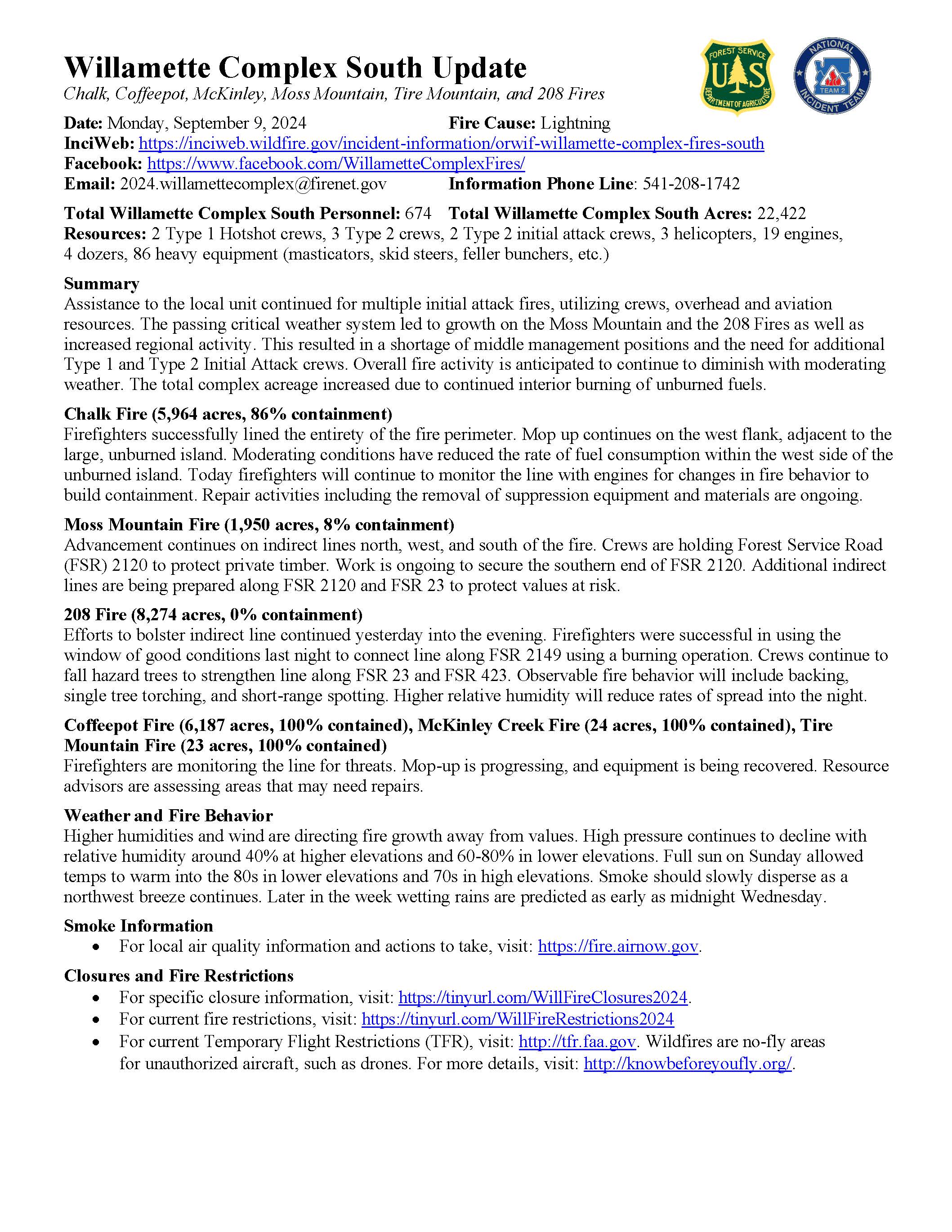
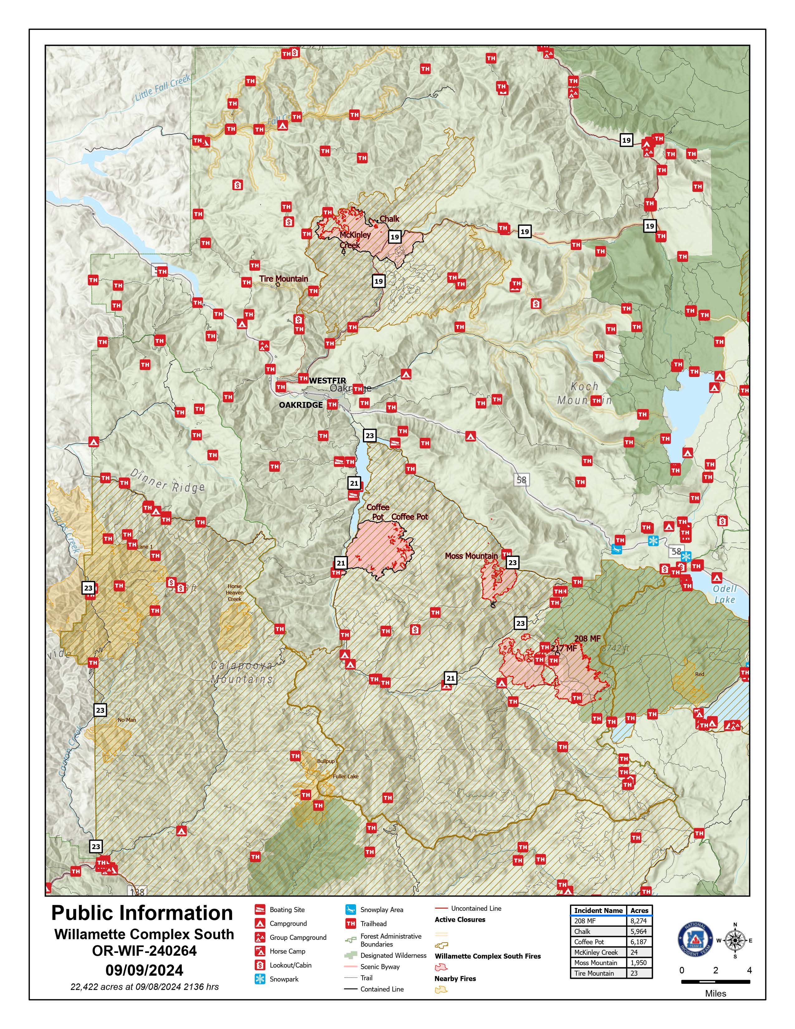
Willamette Complex South Daily Update for Monday Sept 9th 2024 09 09 2024
Related Incident: Willamette Complex Fires - South
Publication Type: News
Willamette Complex South Update
Chalk, Coffeepot, McKinley, Moss Mountain, Tire Mountain, 208, and 217 Fires
Online: https://inciweb.wildfire.gov/incident-information/orwif-willamette-complex- fires-south
Facebook: https://www.facebook.com/WillametteComplexFires/
Email: 2024.willamettecomplex@firenet.gov Information Line: 541-208-1742
Monday, September 9, 2024 Fire Cause: Lightning
Total Willamette Complex South Personnel: 674
Total Willamette Complex South Acres: 22,422
Resources: 2 Type 1 Hotshot crews, 3 Type 2 crews, 2 Type 2 initial attack crews, 3 helicopters, 19 engines, 4 dozers, 86 heavy equipment (masticators, skid steers, feller bunchers, etc.)
Summary
Assistance to the local unit continued for multiple initial attack fires, utilizing crews, overhead and aviation resources. The passing critical weather system led to growth on the Moss Mountain and the 208 Fires as well as increased regional activity. This resulted in a shortage of middle management positions and the need for additional Type 1 and Type 2 Initial Attack crews. Overall fire activity is anticipated to continue to diminish with moderating weather. The total complex acreage increased due to continued interior burning of unburned fuels.
Chalk Fire (5,964 acres, 86% containment)
Firefighters successfully lined the entirety of the fire perimeter. Mop up continues on the west flank, adjacent to the large, unburned island. Moderating conditions have reduced the rate of fuel consumption within the west side of the unburned island. Today firefighters will continue to monitor the line with engines for changes in fire behavior to build containment. Repair activities including the removal of suppression equipment and materials are ongoing.
Moss Mountain Fire (1,950 acres, 8% containment)
Advancement continues on indirect lines north, west, and south of the fire. Crews are holding Forest Service Road (FSR) 2120 to protect private timber. Work is ongoing to secure the southern end of FSR 2120. Additional indirect lines are being prepared along FSR 2120 and FSR 23 to protect values at risk.
208 Fire (8,274 acres, 0% containment)
Efforts to bolster indirect line continued yesterday into the evening. Firefighters were successful in using the window of good conditions last night to connect line along FSR 2149 using a burning operation. Crews continue to fall hazard trees to strengthen line along FSR 23 and FSR 423. Observable fire behavior will include backing, single tree torching, and short-range spotting. Higher relative humidity will reduce rates of spread into the night.
Coffeepot Fire (6,187 acres, 100% contained), McKinley Creek Fire (24 acres, 100% contained), Tire Mountain Fire (23 acres, 100% contained)
Firefighters are monitoring the line for threats. Mop-up is progressing, and equipment is being recovered. Resource advisors are assessing areas that may need repairs.
Weather and Fire Behavior
Higher humidities and wind are directing fire growth away from values. High pressure continues to decline with relative humidity around 40% at higher elevations and 60-80% in lower elevations. Full sun on Sunday allowed temps to warm into the 80s in lower elevations and 70s in high elevations. Smoke should slowly disperse as a northwest breeze continues. Later in the week wetting rains are predicted as early as midnight Wednesday.
Smoke Information
* For local air quality information and actions to take, visit: https://fire.airnow.gov.
The Community Meeting recording is available right here on Facebook as well as on our YouTube channel: https://www.youtube.com/live/7gqAGci8cwQ?si=uUj5aBxItCnZ3F3n
For specific closure information, visit: https://tinyurl.com/WillFireClosures2024.
For current fire restrictions, visit: https://tinyurl.com/WillFireRestrictions2024
For current Temporary Flight Restrictions (TFR), visit: http://tfr.faa.gov. Wildfires are no-fly areas for unauthorized aircraft, such as drones. For more details, visit: http://knowbeforeyoufly.org/.
Closures and Fire Restrictions
- For specific closure information, visit tinyurl.com/WillFireClosures2024
- For current fire restrictions, visit tinyurl.com/WillFireRestrictions2024
- Temporary Flight Restrictions (TFR): tfr.faa.gov for up-to-date areas. Wildfires are a no-fly zone for unauthorized aircraft, including drones. For more information, visit knowbeforeyoufly.org.
Actualizacin del incendio Whisky Creek Sandstone y Blister Creek 09 08 2024
Related Incident: Whisky Creek FireSandstone Fire
Publication Type: News
Tamaño de Whisky Creek: 2,856 acres | Fecha de inicio: 20 de julio |Causa: De orígen humano |Contención 25%
Tamaño de Sandstone: 702 acres | Fecha de inicio: 5 de agosto | Causa: Rayo | Contención 75%
Total de recursos: 321 | Equipos de obreros: 4 | Camiones de bomberos: 7 | Topadoras: 2 | Maquinarias pesadas: 12 | Helicópteros: 3
Los incendios Whisky Creek, Sandstone y Blister Creek arden en un terreno escarpado y escabroso en el Bosque Nacional Mt. Hood, donde los escombros rodantes y los árboles que han sido debilitados por el fuego dificultan el trabajo de extinción.
Whisky Creek:
Ayer, los bomberos realizaron dos misiones de reconocimiento aéreo sobre el incendio Whisky Creek. Estos mostraron que el fuego se había desplazado un poco cerca de Tomlike Mountain y que había crecido un poco en los extremos norte y oeste del incendio. Se localizó un fuego salpicado dentro de la huella del incendio Eagle Creek, justo al norte del extremo del incendio activo. El personal de bomberos no vio suficientes combustibles terrestres que desplazarían el fuego hacia el pequeño fuego salpicado en la huella de ése fuego, aunque hay árboles caídos dispersos que pudieran arder de nuevo. Las cuadrillas continuaron transportando el equipo excedente del área del campamento Rainy Lake. Ayer, los recursos de aeronaves vertieron 6,000 galones de agua en el incendio de Williams Mine. En el extremo este del incendio, empezarán a remover las envolturas de protección de estructura de los edificios.
Se sigue reparando la línea de topadoras a lo largo del camino del Servicio Forestal (FSR) 2810 y en el área de Post Canyon. Los bomberos continuarán vigilando y patrullando a lo largo del extremo este del incendio hoy. El personal está evaluando el corredor del autopista I-84 buscando puntos de espera y acceso para contingencia adicional, por si es necesario.
Sandstone y Blister Creek:
El viernes continuó el trabajo con las excavadoras ya que limpiaron zanjas y repararon a lo largo de FSR 6320 y FSR 7015. Una niveladora reparó la línea de topadoras que se construyó inicialmente para contener el fuego. Hoy, los bomberos monitorearán ambos incendios y continuarán patrullando alrededor del perímetro. Los recursos de extinción de ambos incendios siguen listos para ayudar con el ataque inicial de cualquier incendio nuevo en el área.
Clima: Anoche, los vientos cambiaron del oeste lo que resultó en temperaturas más frescas y una humedad relativa más alta. Hoy, hay una pequeña posibilidad de lluvia, que se despejará para el lunes. El humo continuará asentándose en los valles por la noche, pero se despejará por la tarde. Para ver el pronóstico de humo y seguridad, consulte: oregonsmoke.org.
Cierres: Los cierres de áreas permanecerán en el Bosque Nacional Mt. Hood, el Área Escénica Nacional Columbia River Gorge y el Condado de Hood River. Se establecen cierres para la seguridad del público y de los bomberos; La intrusión en un área de cierre puede interrumpir las actividades de extinción y reparación de incendios, poner en peligro vidas y propiedades, y puede resultar en multas. La información de cierre se encuentra en: https://linktr.ee/whisky_creek.2024.
Seguridad: El público juega un papel importante en la prevención del próximo incendio forestal; tenga cuidado con cualquier posible fuente de incendio. Para obtener consejos de prevención, consulte: https://keeporegongreen.org. La TFR sigue vigente para ambos incendios: https://bit.ly/3T59VWv. Las restricciones contra incendios están vigentes dentro del Bosque Nacional Mt. Hood. Se puede ver más información en: https://www.fs.usda.gov/main/mthood/fire.