
Incident Publication
Homestead Complex and Lane 1 Fire Update 09 08 2024
Related Incident: Lane 1 Fire
Publication Type: News
Homestead Complex and Lane 1 Fires
Update for Sunday, September 8, 2024
Northwest Complex Incident Management Team 8 has taken over management of the Lane 1 Fire from Alaska Complex Incident Management Team 1 as of 7 AM, Saturday, September 7th, along with continuing to manage the Homestead Complex. The Lane 1 Fire is located about four miles north/northwest from two of the fires on the Homestead Complex – the No Man Fire and the Horse Heaven Fire.
Homestead Complex Fire
Start Date: July 19, 2024
Size: 7,671 acres
Containment: 60%
Personnel: 505
Location: 15 miles NE of Glide, OR
Cause: Lightning
Fire Information: https://tinyurl.com/25vkhfjp
Lane 1 Fire
Start Date: July 17, 2024
Size: 25,884 acres
Containment: 97%
Personnel: 195
Location: Approx. 16 miles SE of Springfield, OR
Cause: Lightning
Fire Information: https://tinyurl.com/29k3nnly
The continued warm and dry weather has been producing very active fire behavior on a number of fires within the Homestead Complex, as well as much of the region. Fire managers continue directing limited resources to fires based on threats to property, infrastructure, industry, critical habitat and areas with the highest probability of success while providing for firefighter and public safety.
Crews have been making progress on locating and containing spot fires and/or line slopovers with support from helicopter bucket drops. At the same time, large areas of these fires have been contained and mopped-up and are in “clean-up” and suppression repair stages. This work includes using crews and heavy equipment to chip and haul away forest fuels near control lines. Suppression repair groups are working to minimize the fire impacts to resources, lands, and facilities resulting from firefighting operations. Firefighters are prepared to do initial attack on any new fire starts within the delegated fire operations area and to support local fire resources.
Fire Operations Summary:
Homestead Complex Fire: On the Horse Heaven Creek Fire (2,539 acres, containment: 64%) yesterday, crews were able to construct control line around all of the spot fires that crossed the 3831 Road with the help of a dozer. A Hotshot crew constructed handline around a slopover that occurred on the first day of firing operations tying it back into establish control lines on the west side of the planned burnout area. Firefighters continued with burnout operations to widen the “black line” – adding depth/width of the burned area to strengthen containment. In the northwest corner, firefighters will be improving on, and building additional indirect line going west from the burnout operation down into the Horse Heaven Creek drainage. The objective is to prevent the fire from moving northwest out of the creek basin.
On the No Man Fire (2,078 ac., containment: 28%), crews are patrolling and mopping-up. Chipping operations are continuing and suppression repair is underway.
On the Fuller Lake Fire (1,915 ac., containment: 5%) the fire has progressed north and joined with the Bullpup Fire (496 ac., containment: 17%) at its southern flank. The priority objective for fire managers and crews is to keep fire within established control lines located to the north of the Bullpup Fire in order to prevent the fire from progressing toward critical habitat for wild steelhead (the Frank and Jeanne Moore Wild Steelhead Special Management Area). With that priority objective, crews continue to improve and strengthen primary and secondary containment lines to the north and west along the 300 road system, chipping, road cleanup, patrolling and mopping-up
On the southern flank of the Fuller Lake Fire, fire has progressed south into the Boulder Creek Wilderness Area. The fire has not crossed the primary and secondary containment lines that include the 200 and 300 roads along the west flank of the fire. However, the fire has crossed containment lines in the southeast corner of the fire, including across the 5851 Road. Fire managers are reconning the area further east of the east flank of the fire looking for options to construct additional control lines. Helicopter bucket drops were used to check-up the fire’s progression, and were used to conduct aerial reconnaissance of the fire.
Three of the seven fires on the complex have now reached 100% containment, the Salmon 33 Fire (275 ac.) on August 24, 2024, the Reynolds Butte Fire (334 ac.) on August 22, 2024, and the Lost Bucket Fire (34 ac.) on July 29, 2024. Suppression repair work will continue on the Reynolds Butte and Lost Bucket fires.
On the Lane 1 Fire (25,884 ac., containment: 97%), the “green islands” well interior on the fire continue to burn (consume) with no threat to control lines. Suppression repair continues around the fire where control lines no longer needed for containment are returned to a more natural state. The work includes finishing chipping and log hauling operations, and repairing forest road infrastructure. This work will also make it safer for the public once closures to public managed lands are removed.
Closures and Fire Restrictions:
There is one large closure impacting the Cottage Grove, North Umpqua, and Diamond Lake districts. Emergency Fire Closure ORDER NO. 06-15-24-07: https://www.fs.usda.gov/alerts/umpqua/alerts-notices/?aid=88996. On August 30, 2024, the Umpqua National Forest decreased Public Use Restrictions (PURs) to Level 2, visit https://www.fs.usda.gov/detail/umpqua/news-events/?cid=FSEPRD1202470. For more information on PURs, IFPLs, or other fire management information, visit: https://www.fs.usda.gov/main/umpqua/fire
Weather: Warm and dry conditions will continue. Temperatures will approach the 90s. Winds will light from the southeast in the AM and then become northwesterly in the PM. There remains a slight possibility of a shower or isolated thunderstorm.
The closure order issued by Bureau of Land Management (BLM), Roseburg District, for portions of BLM land which border the Umpqua National Forest Emergency Fire Closure north of Steamboat remains in effect: https://www.blm.gov/sites/default/files/docs/2024-07/orwa-fpo-rbg-072624.pdf
There is a Temporary Flight Restriction (TFR) over the fires. Please remember, if you fly we can’t! If a drone or other aircraft enters the air space, all firefighting aviation equipment will be grounded.
Fire Information Line: 541-208-7100 (Staffed 8 a.m. to 8 p.m.)
Email: 2024.homesteadcomplex@firenet.gov
Facebook: https://www.facebook.com/HomesteadComplexFireInfo/
Red Fire Daily Update 09 08 2024
Related Incident: Red Fire
Publication Type: News
Size: 1,476 acres Location: 5 miles west of Crescent Lake Junction, OR County: Klamath
Start Date: July 17, 2024 Cause: Lightning Containment: 0% Total Personnel: 104
Activities – Yesterday, fire behavior on the Red Fire moderated due to slightly lower temperatures and higher relative humidity. The fire continues to back downslope into the vicinity of the Whitefish Creek Trail. Today, firefighters will monitor and secure the area along the trail using pumps and sprinklers. Crews will haul chips out of the completed shaded fuel breaks and rehabilitation work continues along Forest Service Road 60. Structure protection equipment remains in place along Crescent Lake.
Strategy – A full suppression strategy is being implemented utilizing indirect tactics, shaded fuel breaks, structure protection equipment, trails, and hose lays. When the fire started, an assessment by the initial attack incident commander, local fire managers and forest staff determined the risk to responders was too great to continue with direct attack due to a lack of escape routes and safety zones, snag hazards, and firefighter safety issues in the remote location. Firefighters are continually reevaluating the safest, most effective suppression strategy based on changing weather, fuel conditions, and fire behavior. Firefighter and public safety remain the highest priority in managing this fire.
Closures – To provide for the safety of firefighters, equipment operators, and the public, the Deschutes National Forest emergency closure around Crescent Lake and in the Diamond Peak Wilderness is still in effect. Forest Service Road 60 is closed, and road guards have been posted for public safety. The emergency closure is being reevaluated daily as conditions continue to change. More closure information is available at: https://www.fs.usda.gov/alerts/deschutes/alerts-notices/?aid=89091.
The Pacific Crest Trail (PCT) is closed from north of Windigo Pass (Mile 1883.5) to Highway 58 (Mile 1909.5). The previous PCT detour around the fire has been decommissioned as of noon on September 4. Currently there is not a detour around the closure. A map displaying the PCT closure can be viewed on the Pacific Crest Trail Association’s (PCTA) website at: https://closures.pcta.org/closure/Mr02blDvEwX1SJ9h1H49.
The 2024 season for commercially harvesting Matsutake mushrooms opened for the Deschutes National Forest is open and will close November 4, 2024. The emergency fire closure impacts certain harvesting locations.
Incident Weather, Fire Behavior, and Smoke – Temperatures will be lower today with a higher relative humidity. Slow surface fire spread can be expected. Monday will begin a cooling trend going into the week.
Evacuations – The WILDFIRE! Level 1 – BE READY to Evacuate notice issued by Klamath County Emergency Management for Crescent Lake, Odell Lake, and Crescent Junction areas remains in effect (INCENDIO FORESTAL! Nivel 1 - ESTÉ PREPARADO para evacuar de las siguientes zonas: Crescent Lake, Odell Lake, Crescent Junction). Visit www.klamathcounty.org/300/emergency-management for more information or to sign up for alerts.
Fire Restrictions – Stage 2 Public Use Fire Restrictions – which prohibit open fires, including in developed campgrounds – remain in effect for the Deschutes National Forest. The Industrial Fire Precaution Level is currently Level III “Partial Shutdown.” Visit fs.usda.gov/detail/deschutes/home/?cid=stelprdb5297376 for more information.
Public Invited to Fire Information Sessions 09 08 2024
Related Incident: 2024 - West Fire - TNF2024 - Preacher Fire - TNF
Publication Type: Announcement
Open House Information Sessions in Tonto Village and Whispering Pines
Residents are invited to join members of the Incident Management Team and Forest Service representatives to discuss plans and on-going fire operations. Fire officials will be available to answer questions and provide information. ASL services available.
Session 1: Hellsgate Station 22, Tonto Village
Sunday September 8, 2024 9:00 a.m. - 11:00 a.m.
Session 2: Water Wheel Fire and Medical, Whispering Pines
Monday September 9, 2024 3:00 p.m. - 5:00 p.m.
Williams Mine Fire Update 09 08 2024
Related Incident: Williams Mine Fire-GPNF
Publication Type: News
Williams Mine Fire Update for Sunday, September 8, 2024
A smoky haze continued to hang over the Williams Mine Fire area on Saturday. This smoke shading resulted in another day of moderated fire activity despite poor relative humidity recovery (RH) at night. The smoke is expected to persist today, but conditions may improve as winds shift to coming from the west to northwest. Slightly cooler temperatures and better humidity recovery at night are expected to help keep the fire activity at a moderate level.
The fire edge in the Morrison Creek drainage, west and northwest of the South Climb Trailhead, showed little growth yesterday. Much of the fire spread in this area is from burning snags (dead trees) falling. As the fire burns along the fallen tree, flames spread to other down logs and snags it is contacting. The toppling snags can be over 100 feet tall, allowing for a steady progression of the fire.
Fire personnel have not found a safe way to stop this spread through snag fall. The number, size, and instability of the snags make it extremely dangerous to work near them. Helicopter water drops are being used to cool the fire, with minimal fire growth seen in this area for several days. The water also increases the moisture content of adjacent fuels, making them more difficult to ignite. Fire managers hope to stall the progression of the fire toward the South Climb Trail until weather conditions turn cooler and more humid.
Work is progressing on FS Rd 23. Most of the mastication has been completed, and work had begun on cleaning out culverts and repairing damage done to ditches and the road surface. Physical barriers are being set up on FS Rd 23 to replace the security guards where longer-term closures are expected to be needed.
SAFETY AND CLOSURES:
The Air Quality Index (AQI) measures fine particulate matter 2.5 microns or less in diameter. PM2.5 is associated with the greatest proportion of adverse health effects related to air pollution from wildfire smoke. The AQI reached the “Unhealthy for Sensitive Groups” level yesterday in Trout Lake. Anyone with lung problems should limit exposure to outdoor air when it is smoky. For more information, please see AirNow.
The Confederated Tribes and Bands of the Yakama Nation, Tract D Recreation Area is currently closed, please see Yakama Tract D Road Closure for more information. FS Rd 23 south of FS Rd 90 is still CLOSED to the public due to fire suppression activity. Takhlakh Lake is still closed. The revised closure for the Mt. Adams Wilderness and FS Rd 23 closure can be found at Williams Mine Fire: Area and Road Closure. The Pacific Crest Trail (PCT) is closed from the PCT's intersection with FS Rd 23 to Potato Hill. The current area closure spans the entire Mt. Adams Wilderness.
Bear Fire Incident Update 09 08 2024
Related Incident: Bear Fire, Tahoe National Forest
Publication Type: News
Location: South of Sierra Brooks off Bear Valley Rd., Tahoe National Forest
Personnel: 696
Start Date: 9/2/2024 @ 2:00 PM
Cause: Undetermined
Size: 3,325
Percent contained: 32%
Our main goal on the Bear Fire is to protect the public with care and dedication. We're committed to ensuring the safety of both you and our firefighters while managing the fire to safeguard your forests, communities, and natural areas.
Yesterday, despite afternoon winds with gusts up to 25-30 mph, crews continued to hold the line around the fire, and increased containment south of Badenough Canyon Road to southeast of Smithneck Road and around the Loyalton Rotary Park. Thanks to the hard work of the crews, the fire has stayed within its current footprint despite recent weather changes and gusty winds. This has successfully kept the fire from spreading to private property, nearby communities, and other important areas.
Overnight, crews were successful in improving the direct line on the south side of the fire. They also looked for hot spots and continued the mop-up operations from the previous day.
Today, with wind gusts expected to reach up to 30 mph, efforts will focus on strengthening the control lines and mop up depth. Crews will work on gaining additional depth and continue with the mop-up process. Additionally, suppression repair work has started, concentrating on fixing damaged roads and removing hazard trees.
WEATHER:
Mostly sunny with a maximum temperature of 78 to 81 degrees and relative humidity from 14 to 18 percent. Winds are expected out of the south around 5 to 10mph increasing out of the southwest 10 to 15 mph with gusts up to 25mph this afternoon. A cold front is expected to come in starting Wednesday with overnight lows dropping into the 30 degree temperature ranger.
EVACUATIONS:
Sierra County: Evacuation order and warnings remain in effect. For an interactive map of evacuations, visit: https://protect.genasys.com/search. For updated information with evacuations, visit: http://sierracounty.ca.gov/853/Bear-Fire-2024.
FOREST CLOSURE:
A forest closure has been issued, For more information visit the Tahoe National Forest website at: https://www.fs.usda.gov/alerts/tahoe/alerts-notices.
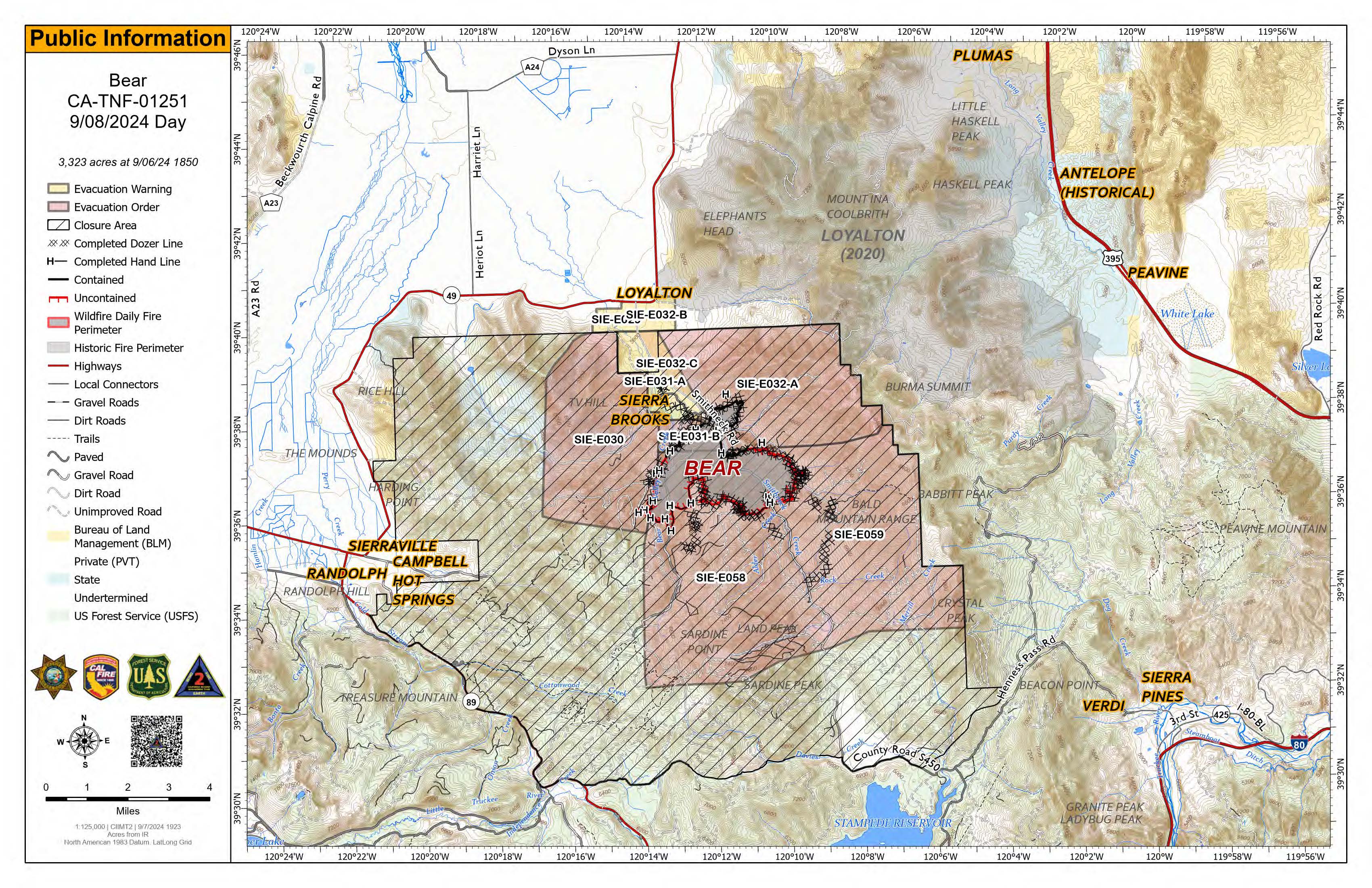
Bear Fire map for September 8, 2024
Whisky Creek Sandstone and Blister Creek Fire Update 09 08 2024
Related Incident: Whisky Creek FireSandstone Fire
Publication Type: News
Northwest Team 12
Whisky Creek, Sandstone and Blister Creek Fires
Sept. 8, 2024
Fire Information: (541) 208-1743, 8 AM - 8 PM
For links to incident information: https://linktr.ee/whisky_creek.2024
Whisky Creek Size: 2,856 acres | Start Date: July 20 | Cause: Human | Containment: 25%
Sandstone Size: 702 acres | Start Date: August 5 | Cause: Lightning | Containment 75%
Total Resources: 321 | Hand Crews: 4 | Engines: 7 | Dozers: 2 | Heavy Equipment: 12 | Helicopters: 3
The Whisky Creek, Sandstone, and Blister Creek Fires are in steep and rugged terrain on the Mt. Hood National Forest where rolling debris and fire-weakened trees challenge firefighting efforts.
Whisky Creek:
Fire managers conducted two aerial reconnaissance missions over the Whisky Creek Fire yesterday. These flights showed some fire growth near Tomlike Mountain and limited growth on the northern and western fire perimeters. One spot fire was located burning inside the Eagle Creek Fire scar just to the north of the active fire edge. Fire personnel did not observe sufficient ground fuels to carry fire near the small spot fire in the burn scar, although there are scattered downed trees that can still reignite and smolder. Crews continued to backhaul excess equipment from the Rainy Lake Campground area. Aviation resources dropped 6,000 gallons of water on the Williams Mine Fire yesterday. Firefighters will begin removing structure protection wrap from buildings on the eastern side of the fire.
Dozer line repair continues along Forest Service Road (FSR) 2810 and in the Post Canyon area. Firefighters will continue monitoring and patrolling along the east side of the fire today. Fire personnel are evaluating the I-84 corridor for additional contingency hold points and access, if needed.
Sandstone and Blister Creek:
Excavator work continued Friday cleaning ditches and repairing along FSR 6320 and FSR 7015. A grader worked to repair dozer line constructed for initial fire containment. Firefighters will monitor both fires today and continue to patrol around the fire perimeter. Firefighting resources from both fires remain available to assist with new initial attack fires in the area.
Weather: Last night, winds turned westerly bringing cooler temperatures and higher relative humidities. There is a small chance of showers today, clearing on Monday. Smoke will continue to settle in valleys overnight but will clear in the afternoon. For smoke forecasts and safety, visit: oregonsmoke.org.
Closures: Area closures will remain in the Mt. Hood National Forest, Columbia River Gorge National Scenic Area, and Hood River County. Closures are put into place for the safety of the public and fire crews; intrusion into a closure area can disrupt fire suppression and repair activities, endanger lives and property, and can result in fines. Closure information is at: https://linktr.ee/whisky_creek.2024.
Safety: The public plays an important role in preventing the next wildfire; please use caution with all potential ignition sources. For prevention tips see: https://keeporegongreen.org. The Temporary Flight Restriction remains in effect for the Whisky Fire: https://tinyurl.com/2s49yrj4. Fire restrictions are in place on the Mt. Hood National Forest: https://www.fs.usda.gov/main/mthood/fire.
Actualizacin Sobre Incendio Park Domingo 8 de Septiembre de 2024 09 08 2024
Related Incident: Park Fire
Publication Type: News
Actualización Sobre Incendio Park: Domingo, 8 de Septiembre de 2024
Administración De Incidentes Complejos Del Área Suroeste - Equipo 2
John Truett - Comandante Del Incidente
Tamaño: 429,603 acres
Fecha de Inicio: 24 de Julio de 2024
Contencion: 99%
Personal Total: 575
Recursos: 1 helicóptero, 12 cuadrillas, 8 camiones de bomberos, 7 topadoras, 23 camiones de agua, 1 masticadoras, 3 astilladoras, 13 excavadoras, 3 máquinas para talar árboles, 6 minicargadoras, 2 apiladoras, 1 retroexcavadora, 5 motoniveladoras
SITUACIÓN ACTUAL: Cosas específicas que necesitan reparación durante la fase de reparación de extinción de incendios se denominan puntos de reparación. La identificación de los puntos de reparación comienza inmediatamente durante la fase de supresión y continúa después de la contención. Ejemplos de puntos de reparación que actualmente se están llevando acabo en tierras del Bosque Nacional Lassen incluyen cercas atravesadas por topadoras, helipuertos y puntos de descenso nivelados en el paisaje, alcantarillas bloqueadas o aplastadas y cruces de arroyos llenos de baches por equipo pesado. El mapa de información pública identifica y muestra el estado de reparación actual de cada punto de reparación. De los 397 puntos de reparación identificados hasta la fecha, más de 150 han sido completados e inspeccionados. Vea el mapa de información pública más reciente en la página InciWeb del incidente. tinyurl.com/2s4y693x.
La Mancomunidad de las Islas Marianas del Norte (CNMI), una comunidad de los Estados Unidos, ha estado proporcionando al incendio Park dos equipos de la isla de Saipan. Los equipos 36 y 32 de CNMI fueron reasignados para ayudar en el incendio Bear después de trabajar varios días con el equipo de Carreteras. De los 29 miembros de la tripulación del Saipan, 14 son bomberos profesionales a tiempo completo y 15 son civiles capacitados en extinción de incendios forestales. Las cuadrillas se encuentran en los Estados Unidos continentales para una asignación de mínimo 60 días para adquirir experiencia adicional en la extinción de incendios forestales.
CLIMA Y SEGURIDAD CONTRA INCENDIOS: Hoy hará un poco más de frío que ayer, una tendencia que continuará durante toda la semana. Los vientos comenzarán bastante tranquilos y aumentarán a lo largo del día, pero las ráfagas se mantendrán por debajo de una velocidad máxima de 20 mph. Ocasionalmente pueden verse señas de humo desde las carreteras o zonas pobladas, pero las líneas de contención no se ven amenazadas en modo alguno por estos tocones, troncos o troncos aislados y humeantes. Los cielos brumosos y llenos de humo son el resultado de incendios en otros estados. Obtenga información sobre la calidad del aire para su área y vea un mapa de humo aquí: tinyurl.com/ypkfbkyn..
CIERRE DE BOSQUES: Partes de los terrenos, caminos y senderos del Bosque Nacional Lassen cerca del incendio están cerrados temporalmente por la seguridad del público y de los bomberos. Las personas son responsables de saber dónde se encuentran en relación con el área de cierre. Si está recreando en sus tierras públicas, prepárese y vea la Orden Forestal No. 06-24-07 y el mapa aquí: fs.usda.gov/alerts/lassen/alerts-notices.
RESTRICCIONES DE INCENDIO: Las restricciones contra incendios siguen vigentes en toda el área. Para más detalles, consulte la Orden Forestal No. 06-24-04 aquí: fs.usda.gov/alerts/lassen/alerts-notices. Encuentre enlaces a las restricciones de incendios de otras agencias de administración de tierras en el árbol de enlaces de información sobre el incendio Park (URL y código QR a continuación).
![]() Información sobre incendio Park (Suroeste CIMT 2) 530-414-9298 2024.park@firenet.gov
Información sobre incendio Park (Suroeste CIMT 2) 530-414-9298 2024.park@firenet.gov
Árbol de Enlace Incendio Park (enlaces a sitios web de información sobre incendios): linktr.ee/park_fire
Rail Ridge Fire Update September 8 2024 09 08 2024
Related Incident:
Publication Type: News
Headlines
- A PUBLIC MEETING will be held TODAY Sunday, September 8, 2024 at 3 p.m. at the John Day Airbase at 72000 Airport Road, John Day, Oregon. The meeting will be livestreamed at https://www.facebook.com/MalheurNationalForest (technology permitting.)
- Find current information at https://linktr.ee/RailRidgeFire
Closures and Evacuations
Closures: Both the Ochoco National Forest and BLM have implemented partial closures due to the fire. For more details and closure maps, visit the Ochoco National Forest, Malheur National Forest, and BLM webpages.
- Evacuations: For the most up-to-date evacuation information, please visit: Crook County: Crook County Emergency Management website and Crook County Sheriff’s Office Facebook page.
- Wheeler County: Visit the Wheeler County Sheriff’s Office Facebook page for real-time updates.
- Grant County: Grant County Emergency Management Facebook page.
Operational Update
Multiple thunderstorms were observed over the fire area. Most fire activity was observed on the northern edge of the fire again, as it burned through timber stringers and sage fields. It continues to be hung up on the ridge south of Dayville/Highway 26 west of the South Fork Road.
Additional Oregon State Fire Marshal (OSFM) task forces arrived on Saturday from Benton and Washington Counties, as well as two from Washington state. Overnight, these crews focused on gaining situational awareness along the fire line, identifying and assessing structures in their assigned areas.
Significant fire activity is expected to continue today. Crews will extend structural surveys and surface preparation around the Dayville area. OSFM crews will continue to support wildland operations while assessing and actively addressing structure threats.
On the eastern and southern edges, the fire held within proposed containment lines, giving firefighters time to build and improve lines. Wildland, local, and OSFM crews held the fire along the Paulina Suplee Highway and provided protection to structures directly adjacent to the fire line.
Weather
The weather today is predicted to remain unsettled, with showers and occasional thunderstorms continuing through the morning. Clearing is anticipated for the afternoon, with light and variable winds and some relief from the heavy smoke. This clearing could result in more active fire behavior again. Winds are expected to remain light, although convective activity could result in stronger, erratic gusts. Daytime temperatures are expected to trend downward in the coming days, although vegetation will remain critically dry, and any new starts from the current lightning are anticipated to find fuels receptive for growth.
#####
Shoe Fly Fire Morning Update 09 08 2024
Related Incident: Shoe Fly Fire
Publication Type: News
Firefighters hold and secure fire, transition to mop up
MITCHELL, Ore. – The Shoe Fly Fire challenged firefighters throughout the day on Saturday, however overnight they were able to hold the fireline and keep the fire within the existing footprint. They were also able to improve the fireline in some areas, working to build it directly adjacent to the fire and widening existing lines. Including Saturday’s fire growth, the fire is now 26,409 acres, with increased containment of 19%.
On the western side of the fire, west of Peggy Butte, crews worked to build fireline along the fire’s edge. This line will be completed by day shift crews today. Spotfires in this area were gridded for heat.
Operations on much of the fire are transitioning to mop up, the tedious task of gridding through the fire’s edge to ensure there is no heat remaining. This will reduce the potential for any flare up crossing the fireline in the future. In lighter fuels such as grass, the mop up will move faster than areas with deeper duff, needle cast, or larger fuels. Areas where the fire did not cleanly burn all the down material and vegetation will also be more time consuming.
A Fire Weather Warning is in place for the fire and surrounding area for potential thunderstorms with abundant lightning. These storms could bring gusty, erratic winds and the potential for new fire starts in the area. Resources from the Shoe Fly Fire continue to be available to support local firefighters and landowners in suppression efforts.
Overnight an Oregon State Fire Marshal structural task force continued work near homes and structures, mitigating fuel and monitoring fire conditions near structures across the incident. Today two task forces will continue to prepare areas near structures as a precaution and patrol near homes within the fire area.
Evacuation notices for residents around the fire continue to be evaluated by the Wheeler County Sheriff, Wheeler County Fire Defense Board Chief, and Team 1 Operations personnel. More information on current evacuations is available at https://tinyurl.com/RAPTOR-Evacuation-Info
Daily Update for the Chimney Fire 09 08 2024
Related Incident: Chimney Fire
Publication Type: News
Southwest Area Complex Incident Management Team 4 assumes command of the Chimney Fire
Daily Update – Sunday, September 8, 2024
Acres: 3,708 Start Date: 9/2/2024
Location: 9 miles northwest of Fairfield, ID Personnel: 320
Containment: 10% Fuels: Timber, brush, grass, understory
Highlights: The Southwest Area Complex Incident Management Team 4 assumed command of the Chimney Fire at 6:00 a.m. A complex team brings additional resources and management capabilities.
Operations: The Chimney Fire experienced short, isolated runs on the northwest corner on Saturday. Minimal fire behavior was observed elsewhere inside existing lines. Along the southern flank of the south fork of Lime Creek, the fire continues to hold. Heavy equipment is being used to reinforce lines on the eastern flank. Crews continue to work on the west flank of the fire while identifying control features to the north. Additional air and ground resources are expected to arrive today. Firefighters and aircraft are available to provide support to initial attack needs as they arise.
Weather: Today, a 30 percent chance of showers in the morning with minimal precipitation expected. Thunderstorm risk continues until the afternoon, with southwest wind gusts up to 30 mph. Temperatures will drop by a few degrees with a high of 82 and low relative humidity levels.
Smoke: Smoke may be visible from the Fairfield area, with continuing smoke and hazy conditions predicted. An interactive smoke map located at https://fire.airnow.gov/ allows you to zoom into your area to see the latest conditions.
Closures: The Sawtooth National Forest has issued an emergency temporary closure of trails and trail segments for the Chimney Fire. The purpose of the closure order is for the protection of firefighters and public during wildfire suppression activities occurring in and around the trails. The full closure order (No. 0414-05-065) and map are available on the Sawtooth National Forest website at https://www.fs.usda.gov/alerts/sawtooth/alerts-notices.
Safety: The health and safety of firefighters and the public are always the first priority. A temporary flight restriction (TFR) is in place over the area, which includes uncrewed aircraft or drones. Flying drones near wildfires is dangerous for pilots and firefighters and can bring wildfire suppression efforts to a halt. Know before you fly. If you fly, we can’t. More information can be found at: https://uas.nifc.gov/.
More Information: https://inciweb.wildfire.gov/incident-information/ideix-chimney-fire /
208-246-8292 / https://www.facebook.com/sawtoothnationalforest / 2024.chimney@firenet.gov / https://www.facebook.com/IdahoDepartmentofLands/