
Incident Publication
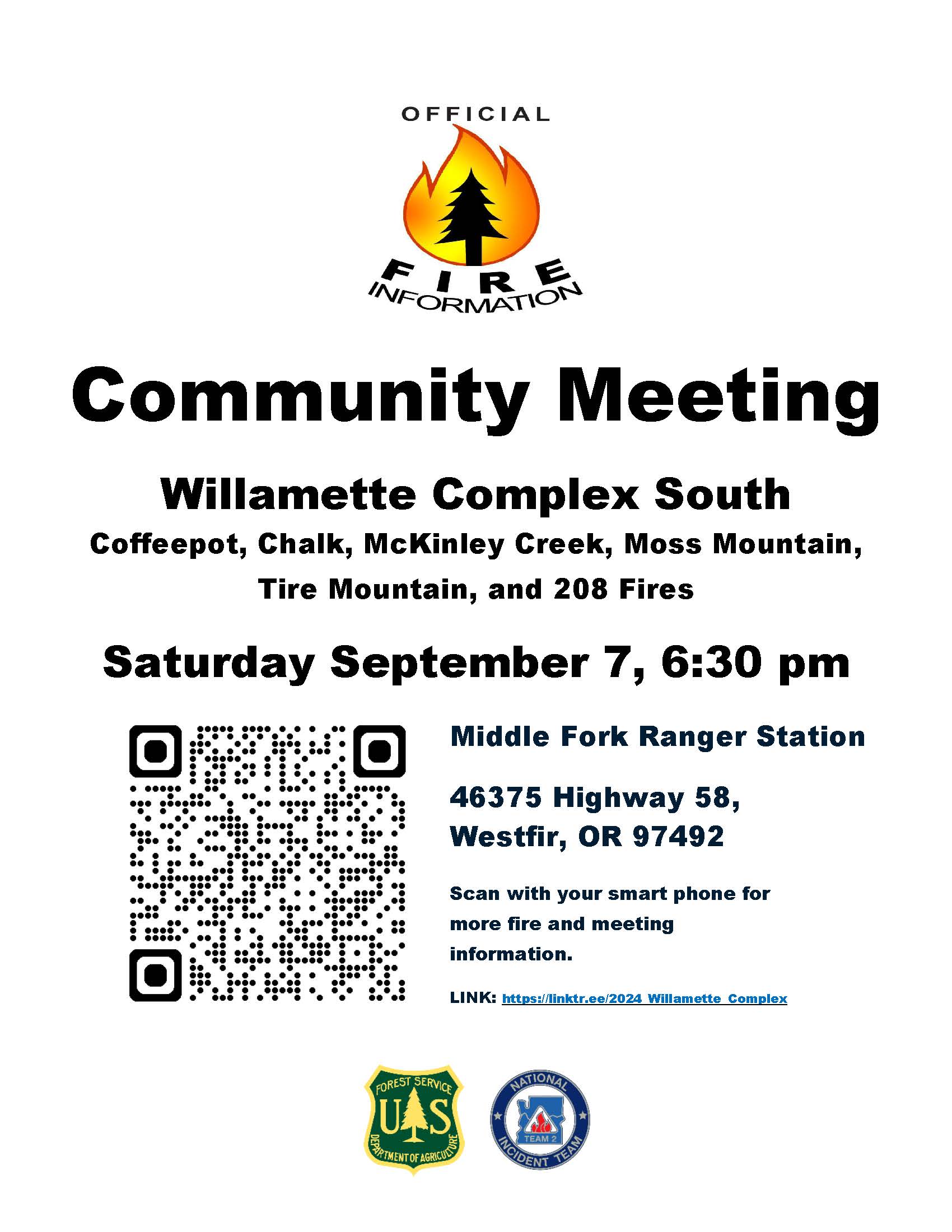
Community Meeting Saturday Sept 7th 630pm Middle Fork Ranger Station 09 06 2024
Related Incident: Willamette Complex Fires - South
Publication Type: Announcement
Community Meeting Tomorrow 6:30pm - Wildfire Update
Join us for a community meeting tomorrow, Saturday, September 7th, 2024, at 6:30 PM PST at the Middle Fork Ranger Station. Subject Matter Experts from the NW2 Incident Command Team will provide briefings on current operations, weather, and fire behavior. Local USFS personnel will also be on hand to answer questions about the July 17th lightning strikes and discuss both past and current priorities.
There will be opportunity for questions after the close of the live meeting.
The meeting will be held in person with a virtual option available on this Facebook page. If you can’t make it, don’t worry—the recording will be posted afterward.
Middle Fork Ranger Station
46375 OR-58
Westfir, OR 97492
Stay safe and informed, and thank you for your continued support.
Fire Information Line: 541-208-1742, staffed 8 a.m. to 8 p.m.
Email: 2024.willamettecomplex@firenet.gov
McDermott Fire Update 09 06 2024
Related Incident: McDermott
Publication Type: News
Incident Commander: Jamie Tyson
Location: 16 miles northwest of Philipsburg, MT
Start Date: 8/26/2024
Cause: Undetermined
Size: 145 acres
Resources on Site: 1 crew; 2 engines; 1 helicopter; miscellaneous heavy equipment
Total Personnel: 31
The McDermott Fire, located in the Upper Willow Creek area, is burning in an inaccessible area containing a large concentration of standing dead trees (“snags”) that pose challenges to ensuring firefighter safety and in responding to potential medical emergencies.
Fire managers from the Forest, working in collaboration with local county officials and cooperating agency representatives, have identified and prioritized critical values at risk in the fire area. The closest values are located three miles to the east of the fire’s location.
Helicopters dropped water on the fire during the initial attack phase, but high winds and the inaccessibility of the fire location resulted in fire growth. Additionally, drift smoke from other large fires to the west and south resulted in the inability to fly additional helicopters for air operations in subsequent days.
CURRENT STATUS/PLANNED ACTIONS:
Helicopters will continue to support ground crews with water bucket drops on the east flank to cool hot spots and prevent fire progression. The crew will continue to construct handline on the fire, east of the Black Pine Trail.
WEATHER AND FIRE BEHAVIOR:
Gusty outflow winds associated with passing thunderstorms materialized over the fire area days ago, with little to no measurable precipitation. Temperatures are expected to continue in the mid to upper 80s for at least the next week.
Fire behavior initially was active, with spotting and group torching and a moderate rate of spread. The fire showed little to no movement and was burning internal pockets of timber in the McDermott Ridge area. Small plumes of smoke from group torching of trees on the northern flank near McDermott Gulch were visible today.
CLOSURES AND RESTRICTIONS:
The Forest is in Stage 1 Fire Restrictions. Campfires are allowed only in a permanent metal fire grate/ring provided by the Forest Service in a designated, developed recreation site. Smoking is restricted to vehicles, in buildings, or in an area clear of flammable materials. Devices with an on/off switch that use LPG fuels are allowed in an area clear of flammable materials within 3 feet of the device.
Forest fire managers are working on trail closures. They encourage the public to please avoid the fire area as to not interfere with fire fighting operations.
Cottage GroveLane 1 Fire Update 09 06 2024
Related Incident: Lane 1 Fire
Publication Type: News
Lane 1 Fire Information
Email: 2024.Lane1@firenet.gov
Fire Information: (541) 649-2399 voice/text
Friday, Sept. 6, 2024
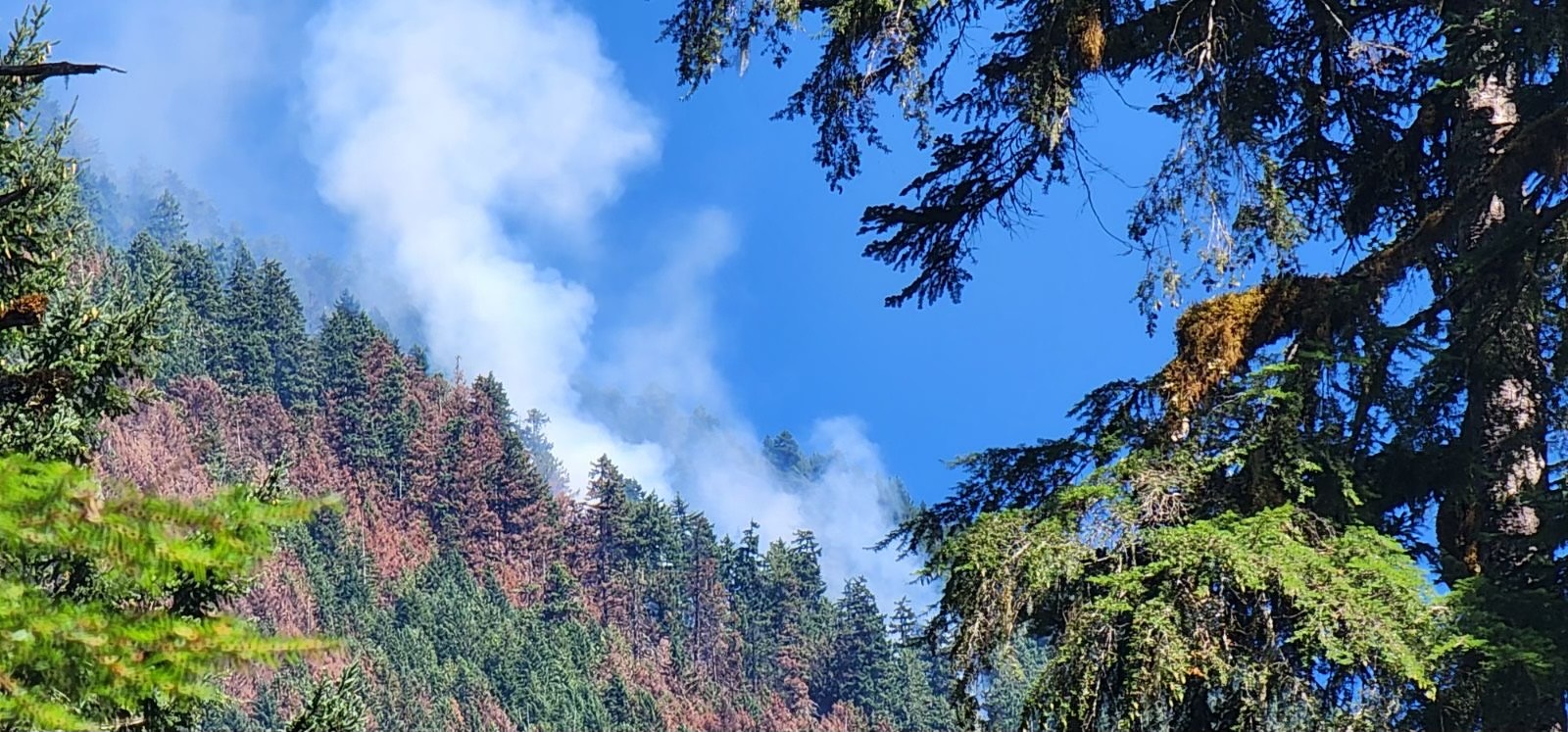
The Lane 1 Fire became active Thursday afternoon as warm, dry conditions combined with drainage aligned winds rekindled smoldering interior pockets of unburned vegetation. The most active portion of the fire was along the Calapooya Divide between Shane Saddle and Twin Rocks. The fire spotted across the line east of the intersection of national forest service roads 2328 and 2358 in the headwaters of the Little Rock Creek drainage. Firefighters are working Friday morning on a small spot just east of 2358 NFSR. An overnight reconnaissance flight with infrared sensors detected an additional spot deeper into the drainage. Firefighters are gridding that area Friday morning. Several other interior pockets around the fire put up smoke as they too became more active Thursday, but none of those are challenging containment lines. The fire increased more than 400 acres to an estimated 25,732 acres as these interior islands were consumed.
The suppression repair continues around the fire as control lines no longer needed for containment are returned to a more natural state. Firelines are repaired by building water bars to direct water runoff from exposed soil to a more suitable direction so as not to create wash outs. Vegetative material removed from the line is pulled back over exposed areas to prevent erosion. Dozer lines require heavy equipment to restore so the areas are protected making it easier for the ground to recover. Fire weakened and other hazard trees are being removed from along firelines for the safety of firefighters working in the area. This work will also make it safer for the public once closures to public managed lands are removed. Large fuels are being removed as fire prevention measures to lessen the fuel load for future wildland fires. This woody debris is being chipped and used as ground cover. Some logs are being salvaged and stored in landings for the BLM and forest service.
Alaska Complex Incident Management Team 1 has reached the end of their assignment and are in the process of transitioning management of the Lane 1 Fire to Northwest Complex Incident Management Team 8 who is managing the neighboring Homestead Complex. The two teams have been shadowing each other to learn the operation. The transfer of command will occur Saturday morning. Suppression repair work will continue on the Lane 1 Fire.
Copperfield Fire Daily Update 962024 09 06 2024
Related Incident: Copperfield Fire
Publication Type: News
Chiloquin, Ore. – Predicted weather was moderate, allowing crews the opportunity to increase containment, particularly in the areas where there are nearby structures. Overnight, infrared drones identified a few hot spots on the east side of the fire and crews were able to find them and mop up quickly. Crews continued to expand the perimeter depth of the fire in previously burned areas (black line) that are now cold and being mopped up. Overall, containment increased to 43%.
The Oregon State Fire Marshal (OSFM) Incident Management Team has demobilized from the fire and are returning to their home agencies. Their work has built strong containment around all homes and structures. ODF IMT Team 3 will continue to monitor and patrol areas and work on any new threats in those areas. ODF Team 3 will remain in command of the fire continuing containment through mop up operations.
Today there is a Red Flag Warning from 1-9 PM for strong winds, higher temperatures, and lower relative humidity. There is a 20% chance of a dry thunderstorms that could bring winds with 40-50 MPH gusts. This will be another test of the current work and containment measures. The goal is to push deeper into the black and increase mop up while staying alert during the weather warning.
Evacuation levels will continue to be evaluated with the increase of the fire containment. Evacuation levels are determined by the Klamath County Sheriff's Office in conjunction with fire officials and agency administrators. Current evacuation areas and levels can be found at https://www.klamathcounty.org/300/Emergency-Management.
For Hunters Update on Forest Closures and Fire Restrictions 09 06 2024
Related Incident: Willamette Complex Fires - South
Publication Type: Announcement
🦌 Hunting Season Update: Important Information on Fire Restrictions and Forest Closures 🦌
With hunting season here, we want to remind everyone that there are fire-related closures and fire restrictions in place on the Willamette National Forest. We understand that these closures impact hunting plans.
The current closures are primarily for the safety of firefighters and the public. With active fire operations, including emergency vehicles and heavy machinery on forest roads, a large closure area is necessary to ensure that firefighters can focus on managing the fire without needing to evacuate visitors should conditions change rapidly.
We will reduce the closure area as soon as it's safe, and in the meantime, we're here to help you find nearby areas that are open and safe for hunting and recreation.
Make your hunting enjoyable by following these tips:
• The public is encouraged to observe closures, pay attention to evacuation warnings, and avoid active wildfire areas to give firefighters and first responders the room they need to move heavy equipment and work safely to protect the public and property from wildfire.
• Know before you go where there are forest closures in effect. https://www.fs.usda.gov/willamette
• Drive and park carefully: Don’t park vehicles on dry, grassy areas because heat from the exhaust can ignite the dry grass. Avoid operating a vehicle away from developed roads and ensure that motorized recreation vehicles have the required spark arresters. Pay attention to any towing equipment or dragging chains that could start a fire.
• Remember that open fires, such as grills and campfires, are currently not allowed in several of Oregon's National Forests including the Willamette. Use only pressurized liquid or gas appliances that can be switched on/off. The Willamette USFS Fire Restriction order is located here:
chrome-extension://efaidnbmnnnibpcajpcglclefindmkaj/https://www.fs.usda.gov/Internet/FSE_DOCUMENTS/fseprd1047207.pdf
For hunting regulations, contact:
Oregon Department of Fish and Wildlife at
(503) 947-6000 and toll free at (800) 720-6339
Stay safe and informed, and thank you for your continued support.
Inciweb: https://inciweb.wildfire.gov/incident-information/orwif-willamette-complex-fires-south
Fire Information Line: 541-208-1742, staffed 8 a.m. to 8 p.m.
Email: 2024.willamettecomplex@firenet.gov
Smoke Information for Oakridge:
https://www.airnow.gov/?city=Oakridge&state=OR&country=USA
Closures and Fire Restrictions:
For specific closure information, visit tinyurl.com/WillFireClosures2024
For current fire restrictions, visit tinyurl.com/WillFireRestrictions2024
#WillametteComplex South
#ChalkFire #CoffeepotFire #McKinleyFire #MossMountainFire, #TireMountainFire #208Fire
RailroadDaly update September 6 2024 09 06 2024
Related Incident:
Publication Type: News
Update 6 September 2024
Location: Railroad Creek/ Skalkaho Creek confluence, 26 miles SE of Hamilton
Start Date: 7/25/2024
Cause: Lightning
Size: 383 acres for Railroad & 1,867 acres for Daly
18 Total Personnel
KEY MESSAGE
A portion of Skalkaho Hwy (Hwy 38) is closed to traffic (see details below). There is a temporary flight restriction in place over the fire area.
CURRENT STATUS
There was minimal growth on either the Daly or the Railroad fire, but with fuels drying out the fire has the potential to grow on all flanks. Crews are focused on point protection tactics in the immediate vicinity of the fire, and continue to manage risk by limiting exposure to firefighters and the public. Snagging operations along Hwy 38 will continue today. Today (9/6) fire crews plan to start burnout operations between the Railroad fire perimeter and the Daly Fire perimeter. Burnout operations allow fire managers to intentionally reduce the amount of unburned fuel between the two fires. These operations will also allow crews to protect the overstory by allowing a lower intensity fire across the landscape. Given the warming and drying weather conditions more active fire behavior is expected.
WEATHER
The fire area is drying out from rain on September 3. Any thunderstorms, which are forecasted for the weekend, could cause outflow winds. A ridge of high pressure is building over the region, lasting through early next week. Temperatures will trend warmer with a return of intense thermal belts. A few showers and thunderstorms are possible by Sunday afternoon. Long term models show the ridge will most likely break down next week.
CLOSURES
Because the Daly Fire exhibited increased fire behavior late on Monday night with fire crossing over the Skalkaho Hwy (Highway 38), an expanded Road Closure is in effect from Black Bear Campground on Skalkaho Hwy (Hwy 38) to the Skalkaho Pass. There are barricades in place, and Gird Point Lookout is closed.
See InciWeb for map and details on area closure: https://inciweb.wildfire.gov/incident-closures/mtbrf-railroaddaly-fire
Miners Complex Daily Update 09 06 2024
Related Incident: Miners Complex Fires
Publication Type: Announcement
11:00 AM, September 6, 2024
Estimated size: 1,098 acres
Start Date/Time: July 17, 2024
Area of Origin: 21 air miles east of Darrington WA
Cause: Lightning
Fuels/Topography: timber, rugged terrain
Structures Damaged: None, there are no homes threatened at this time.
Evacuations: None
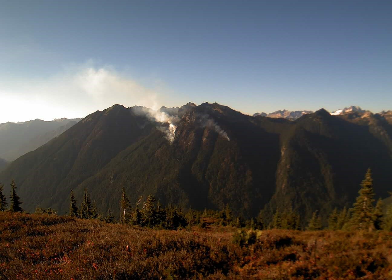
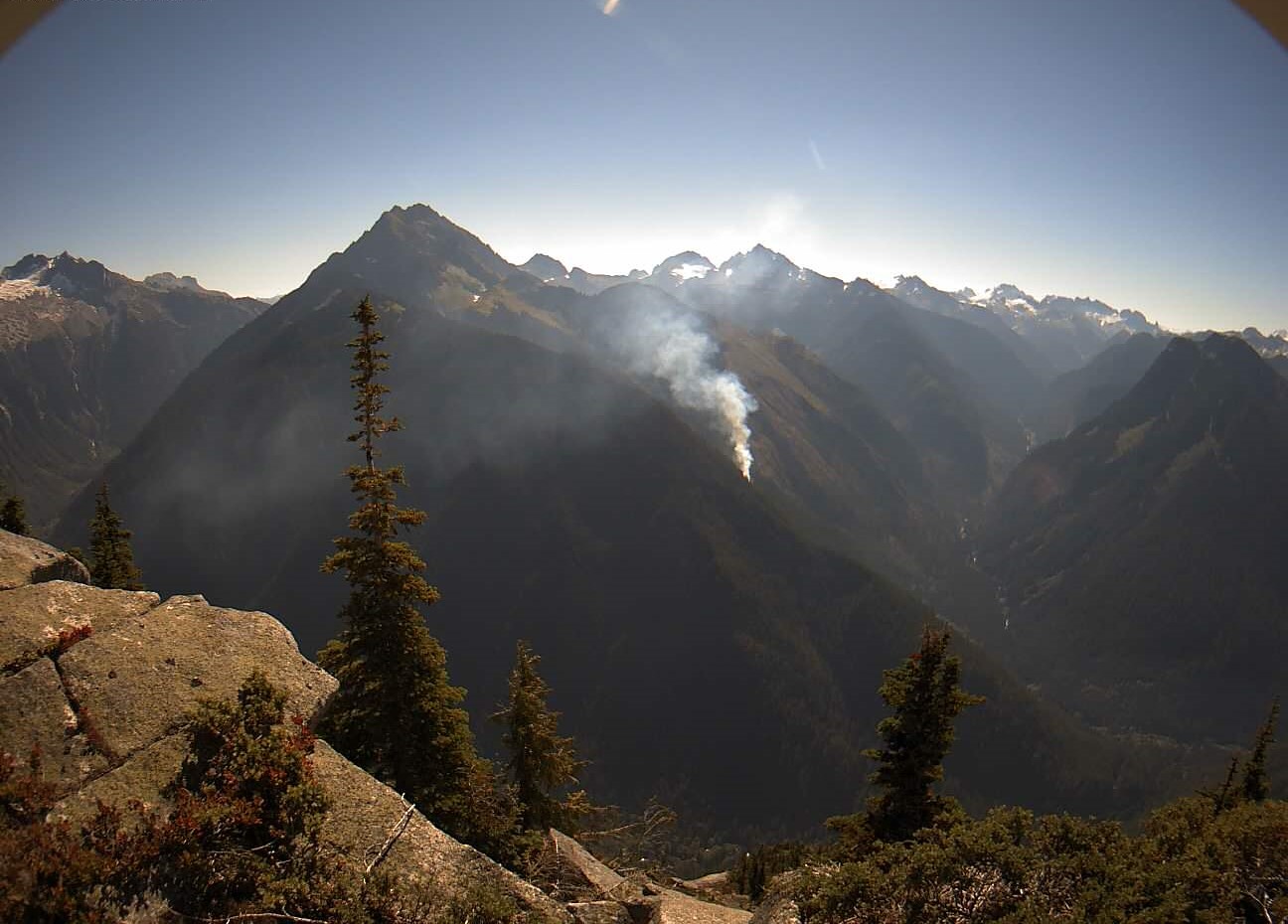
The Miners Complex consists of eight wildfires caused by lightning strikes in the Mt. Baker-Snoqualmie National Forest. The fires included in the complex are Miners Fire, Vista Ridge Fire, Dolly Creek Fire, Sulphur Three Fire, Sulphur Four Fire, Sulphur Thirty-Four Fire, Plummer, and Middle Ridge Fire.
Update: A reconnaissance flight on Thursday, September 5 allowed fire managers to observe and assess fire behavior. The Sulphur Fires showed smoke in the interior and along the edges of the fire from heavy fuels burning, but perimeter growth was not significant. The Dolly Creek Fire showed smoke but no growth in perimeter. The Miners Ridge and Middle Ridge Fires showed no visible smoke. Increased fire activity is expected in the next few days as the Red Flag warning continues until 11pm PST Friday night, and warm temperatures are forecasted over the weekend. Firefighter crews continue patrols of the Miners Complex along with accompanying rehab work.
Weather: On Friday, September 6, hot, dry and unstable conditions linger due to upper ridging aloft and a thermal trough at the surface. Easterly winds at times are also a concern, but speeds should remain below critical thresholds. This offshore flow will once again hinder RH recoveries tonight. Saturday will prove transitional, where onshore flow returns but it may not have much effect on temperatures or RH values. Cooler conditions and increasing moisture expected to be more impactful Sunday and into next week. High temperature around 88°F, with east winds between 5-6 mph shifting west in the afternoon. On Saturday, September 7, the high temperature will be around 91°F, with southeast winds between 5-6mph.
Smoke: For more information on smoke and air quality please visit: https://wasmoke.blogspot.com/
Closures: The following is a summary of the areas closed due to the fires in the Miners Complex: Pacific Crest National Scenic Trail #2000.2 from Mica Lake to Suiattle Pass, Suiattle River Trail #784, Miners Ridge Trail #785, Buck Creek Pass Trail #789, Miners Cabin Trail #795, Grassy Point Trail #788, Sulphur Mountain Trail #794, Sulphur Creek Trail #793, Sulphur Creek Campground, Sulphur Creek Trailhead, and the Downey Creek trailhead. Suiattle River Road, closure beginning at Downey Creek trailhead. The full Closure Orders visit: https://www.fs.usda.gov/mbs Forest Restrictions: The Mt. Baker-Snoqualmie has lifted the full campfire ban and forest-wide shooting restrictions, effective 8/28/2024. Additional details at: www.fs.usda.gov/mbs
###
Actualizacin del incendio Whisky Creek Sandstone y Blister Creek 09 06 2024
Related Incident: Whisky Creek FireSandstone Fire
Publication Type: News
Tamaño de Whisky Creek: 2,105 acres | Fecha de inicio: 20 de julio |Causa: De orígen humano |Contención 25%
Tamaño de Sandstone: 702 acres | Fecha de inicio: 5 de agosto | Causa: Rayo | Contención 75%
Total de recursos: 369 | | Equipos de obreros: 9 | Camiones de bomberos: 7 | Topadoras: 3 | Maquinarias pesadas: 8 | Helicópteros: 3
Los incendios Whisky Creek, Sandstone y Blister Creek arden en un terreno escarpado y accidentado en el Bosque Nacional Mt. Hood, donde los escombros rodantes y los árboles debilitados por el fuego dificultan el trabajo de extinción.
Whisky Creek:
Ayer, las temperaturas más altas y los vientos del este resultaron en una intensidad de incendio más fuerte, y hoy se espera más humo debido a las condiciones de bandera roja. El fuego creció un poco y los bomberos están bien preparados para cualquier intensidad más fuerte del fuego. Los bomberos siguen monitoreando y patrullando, buscando fuentes de calor cerca del perímetro del incendio y asegurando los focos de calor si es necesario. Ayer, las cuadrillas comenzaron a cargar el exceso de manguera y suministros del cortafuegos a cargas externas. Removieron unas 10,000 libras de equipo en un helicóptero. Estos suministros excedentes (o backhaul) se devolvieron al campamento de bomberos para ser enviados a los almacenes regionales de bomberos y así se pueden renovar para usarse en el futuro. La niveladora trabajó en la carretera del Servicio Forestal (FSR) 2810, mientras que un equipo siguió reparando la carretera del Servicio Forestal 2821. Aeronaves del incendio Whisky Creek continuaron apoyando en el incendio Williams Mine, al verter 45,000 galones de agua.
Hoy, las cuadrillas continuarán preparando las cargas para removerlas mediante helicóptero. Hoy, dos cuadrillas llegarán para ayudar los incendios Whisky Creek y Sandstone. La niveladora y el tanque de agua del incendio Sandstone se transferirán al incendio Whisky Creek para continuar con las reparaciones prioritarias de la carretera.
Sandstone and Blister Creek:
Se continuó reparando la carretera del Servicio Forestal 6320. Están por llegar dos excavadoras para trabajar en la reparación. Los bomberos continuarán patrullando los incendios Sandstone y Blister Creek en búsqueda de focos de calor y trabajarán en reparar senderos y carreteras. Los bomberos permanecen disponibles para ayudar con el ataque inicial de cualquier incendio nuevo
Clima: Permanece vigente una advertencia de bandera roja hasta el viernes a las 11 p.m. por causa de vientos racheados de alta mar y la baja humedad relativa. Se prevé una advertencia de calor excesivo para el viernes y el sábado. El viernes las temperaturas estarán entre 75 a 85 grados en ambas zonas de incendios. Los vientos soplarán del este de 25 a 35 mph. El humo se desplazará hacia la zona, pero para la tarde se habrá despejado. Para saber sobre los pronósticos de humo y la seguridad, consulte oregonsmoke.org.
Cierres: Los cierres de áreas permanecerán en el Bosque Nacional Mt. Hood, el Área Escénica Nacional Columbia River Gorge y el Condado de Hood River. Por su seguridad, por favor respete las órdenes de cierre del área, así como por la seguridad de nuestros bomberos. Información sobre los cierres se puede ver en https://linktr.ee/whisky_creek.2024.
Seguridad: El público juega un papel importante en la prevención del próximo incendio forestal; tenga cuidado con cualquier posible fuente de incendio. Para obtener consejos de prevención, consulte: https://keeporegongreen.org. La TFR sigue vigente para ambos incendios: https://bit.ly/3T59VWv. Las restricciones contra incendios están vigentes dentro del Bosque Nacional Mt. Hood. Se puede ver más información en: https://www.fs.usda.gov/main/mthood/fire.
Pincer Two Fire Daily Update 09 06 2024
Related Incident: Pincer Two Fire
Publication Type: Announcement
11:00 AM, September 6, 2024
Estimated size: 211 acres
Start Date/Time: July 17, 2024
Area of Origin: Johannesburg Mountain. 1 Mile East of Mineral Park C.G.
Cause: Lightning
Fuels/Topography: Timber, rugged terrain
Structures Damaged: None, there are no homes threatened at this time.
Evacuations: None
Closures: Cascade River Road at and including Marble Creek Campground, Mineral Park Campground, and all tributary roads, trailheads, and trails are all closed. The public is not to enter the area for public and firefighter safety.
Full closure orders available at: https://www.fs.usda.gov/mbs
Update: The Red Flag warning for hot, dry conditions on Thursday, September 5 led to increased activity on the southeast slope of the fire. Sustained east winds between 5-10mph on the ridge tops and low relative humidities were present. A reconnaissance flight is planned for the morning of Friday, September 6 to track any fire growth and assess fire behavior. Increased fire activity is expected in the next few days as the Red Flag warning continues until 11pm PST Friday night, and warm temperatures are forecasted over the weekend. Firefighters will continue to track any rolling debris and hot spots and monitor fire behavior over the weekend.
Weather: On Friday, September 6, hot, dry and unstable conditions linger due to upper ridging aloft and a thermal trough at the surface. Easterly winds at times are also a concern, but speeds should remain below critical thresholds. This offshore flow will once again hinder RH recoveries tonight. Saturday will prove transitional, where onshore flow returns but it may not have much effect on temperatures or RH values. Cooler conditions and increasing moisture expected to be more impactful Sunday and into next week. High temperature around 88°F, with east winds between 5-6 mph shifting west in the afternoon. On Saturday, September 7, the high temperature will be around 91°F, with southeast winds between 5-6mph.
Smoke: For more information on smoke and air quality please visit: https://wasmoke.blogspot.com/
Air Space Restrictions: There are no air space restrictions at this time.
Forest Restrictions: The Mt. Baker-Snoqualmie has lifted the full campfire ban and forest-wide shooting restrictions, effective 8/28/2024. Additional details at: www.fs.usda.gov/mbs
###
Homestead Complex Update 09 06 2024
Related Incident:
Publication Type: News
Homestead Complex Fire Update for Friday, September 6, 2024
Start Date: July 19, 2024 | Location: 15 miles Northeast of Glide | Total Number of Fires: 7 | Total Personnel: 560 | Total Fire Acreage: 5,926 | Cause: Lightning | Overall Complex Containment: 60%
Fire Operations Summary: The fires in the east half of the complex were very active yesterday, and are expected to remain active today. Yesterday, firefighters began tactical burnout operations on the Horse Heaven Fire. As the firing progressed, some spot fires crossed over the 3831 Road and crews worked into the night to contain them. The area of the fire down in the Windy Creek drainage also progressed up the northwest slopes of the drainage and crews will be working on containment of any slopovers. The firing phase of this burnout operation will continue today if burning conditions remain favorable.
Across the fire complex of seven fires, firefighters are working to complete and secure all primary and secondary (contingency) control lines. This work includes using crews and heavy equipment to chip and haul away forest fuels near control lines. Patrol and mop-up operations continue, and suppression repair groups are working to minimize the fire impacts to resources, lands, and facilities resulting from firefighting operations. Firefighters are prepared to do initial attack on any new fire starts within the delegated fire operations area and to support local fire resources.
On the No Man Fire (2,072 ac., containment: 28%), crews are patrolling and mopping-up. Chipping operations are continuing and suppression repair is underway. On the Horse Heaven Creek Fire (2,304 ac., containment: 64%), firing for burnout operations began yesterday and will continue today on the north flank. Crews will be working to contain spot fires along the 3831 Road and along the handline on the northwest flank. Helicopter bucket drops will be supporting operations. Mop-up and line improvement continues on other areas of the fire. On the Bullpup (473 ac., containment: 17%) and Fuller Lake fires (426 ac., containment: 5%) yesterday, these fires increased in activity in response to hotter weather. A one-acre spot was contained on the northeast corner of the Fuller Lake Fire. Crews will be searching for any additional spots to contain. Helicopter bucket drops helped control the spot fire and to moderate fire behavior. Work to reinforce control lines on the 300 and 200 roads is nearing completion. Suppression repair work will continue on the Reynolds Butte and Lost Bucket fires.
Weather: Very hot and dry. Temperatures into the 90s. Light easterly winds in the AM changing to northwest in the PM. A Red Flag warning will be in effect from 1 to 9 PM for chance of thunderstorms.
Closures and Fire Restrictions:
There is one large closure impacting the Cottage Grove, North Umpqua, and Diamond Lake districts. Emergency Fire Closure ORDER NO. 06-15-24-07: https://www.fs.usda.gov/alerts/umpqua/alerts-notices/?aid=88996. On August 30, 2024, the Umpqua National Forest decreased Public Use Restrictions (PURs) to Level 2, visit https://www.fs.usda.gov/detail/umpqua/news-events/?cid=FSEPRD1202470. For more information on PURs, IFPLs, or other fire management information, visit: https://www.fs.usda.gov/main/umpqua/fire
The closure order issued by Bureau of Land Management (BLM), Roseburg District, for portions of BLM land which border the Umpqua National Forest Emergency Fire Closure north of Steamboat remains in effect: https://www.blm.gov/sites/default/files/docs/2024-07/orwa-fpo-rbg-072624.pdf
There is a Temporary Flight Restriction (TFR) over the Homestead Complex Fire. Please remember, if you fly we can’t! If a drone or other aircraft enters the air space, all firefighting aviation equipment will be grounded.
Fire Information Line: 541-208-7100 (Staffed 8 a.m. to 8 p.m.)
Email: 2024.homesteadcomplex@firenet.gov Smoke Outlook: https://outlooks.airfire.org/outlook/d393fd74
Facebook: https://www.facebook.com/HomesteadComplexFireInfo/
Inciweb: https://inciweb.wildfire.gov/incident-information/orupf-homestead-complex