
Incident Publication
Forest Service Burn Area Emergency Response BAER begins for Alexander Mountain Fire 08 11 2024
Related Incident:
Publication Type: News
As the Alexander Mtn Fire nears full containment, the USDA Forest Service’s Roosevelt National Forest has organized a team to complete a Burned Area Emergency Response (BAER) assessment. Information will be posted on the Alexander Mountain Post-fire BAER InciWeb page throughout the process.
BAER surveys are rapid assessments that evaluate the burned area to identify watersheds having increased potential for post-fire flooding, erosion, debris flows and rockslides. Teams consist of scientists and specialists, including hydrologists, soil scientists, engineers, botanists, biologists, archeologists and more. These teams collect data during their burned area surveys and present their findings and recommended emergency stabilization treatments or actions in a BAER assessment report.
BAER teams utilize satellite imagery which is then field validated and adjusted where needed by soil specialists to produce a map that shows the levels of soil burn severity on the watersheds. Changes in soil properties are the primary cause of increased post-fire erosion, flooding and debris flow potential. This is the first step in assessing potential watershed impacts from the wildfire to any National Forest values that may be at risk from potential increased flooding, sedimentation, debris flows and rockslides. BAER emergency response efforts are focused on the protection of human life, safety and property, as well as critical cultural and natural resources such as the water quality of streams on National Forest System lands.
BAER reports are shared with interagency cooperators who work to identify and prepare for potential post-fire flooding and debris flow impacts. Larimer County has a website with recovery resources for residents impacted by the Alexander Mountain Fire. Other flood preparedness information is available at www.ready.gov/floods and www.floodsmart.gov.
This is just one step of recovery. The Arapaho and Roosevelt National Forests and Pawnee National Grassland is working with many cooperators in the area to look at longer-term recovery needs following the fire.
SAFETY MESSAGE: Everyone near and downstream from the burned area should remain alert and stay updated on weather conditions that may result in heavy rains over burn scars. Flash flooding may occur quickly during heavy rain events. Be prepared to take action.
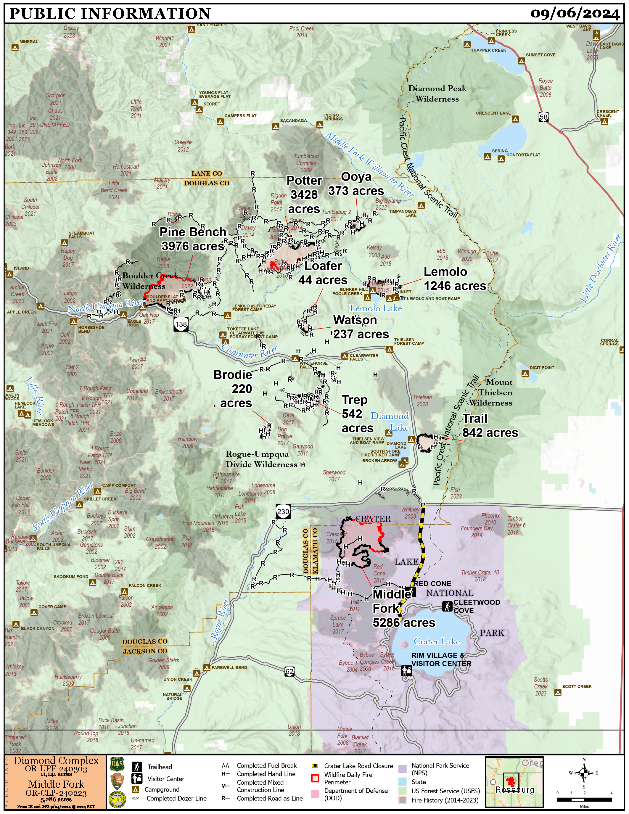
Diamond Complex and Middle Fork Fire Update for September 6 2024 09 06 2024
Related Incident: Middle Fork Fire
Publication Type: News
Diamond Complex
- Size: 11,141 acres
- Containment: 81%
- Personnel: 801
- Location: 18 miles SW of Chemult, OR
- Start Date: July 19, 2024
- Cause: Undetermined
Middle Fork Fire
- Size: 5,286 acres
- Containment: 61%
- Personnel: 51
- Location: Crater Lake National Park
- Start Date: July 17, 2024
- Cause: Undetermined
Ride the Rim, Red Flag Warning and Fire Restrictions
RIDE THE RIM: The North Entrance to Crater Lake National Park will reopen on Saturday, September 7, at 6 a.m. for Ride the Rim. If crews are unable to complete hazardous reduction work related to the Middle Fork Fire on Friday, the North Entrance will close again on Sunday morning so they can resume work.
HWY. 230 ON THE PARK’S NORTHWEST SIDE: Firefighters are using heavy equipment to remove downed and dead wood in this area. Slow down when approaching firefighter activity.
CLOSED AREAS: Do not enter closed areas or drive around barriers. Entire roadways may not be blocked to allow firefighter traffic. Areas are closed due to dangerous conditions like falling trees, heavy equipment and road grading.
RED FLAG WARNING: A red flag warning, the most elevated fire conditions, is in effect today with a 60% chance of dry thunderstorms. Know where you are and pay attention to fire restrictions. The Umpqua and Rogue River-Siskiyou National Forests and Crater Lake National Park have different fire restrictions in place. Crater Lake National Park has a fire ban whereas the national forests have Level 2 fire restrictions. Follow information posted on their websites.
- Crater Lake National Park: https://www.nps.gov/crla/index.htm
- Umpqua National Forest: https://www.fs.usda.gov/umpqua
- Rogue River-Siskiyou National Forest: https://www.fs.usda.gov/rogue-siskiyou
Current Fire Situation
The Diamond Complex includes 32 fires in the Umpqua National Forest. Thirty are 100% contained meaning firefighters have established a control line around them and are confident they will remain in their current footprints. Crews are checking fires to confirm their status and assess whether suppression repair is needed. An initial attack group is prepared to respond to any new wildfires that may result from today’s predicted thunderstorms.
Middle Fork Fire
Today crews will continue heavy equipment operations near the park’s North Entrance. They are also cleaning up roads and repairing areas disturbed by suppression activities, especially along Hwy 230. Firefighters will continue securing edges on the fire’s north and east sides and patrolling for hotspots.
Diamond Complex
- Pine Bench Fire (north of Hwy. 138 near Dry Creek, 3,976 acres, 66% contained): Firefighters continue to patrol for hotspots and complete suppression repair. They finished removing structure protection from the lookout tower.
- Potter Fire (north of Hwy. 138, 2 miles southeast of Potter Mountain, 3,428 acres, 55% contained): Firefighters continue to construct the primary control line on the southwest corner of the fire. They are still finding heat on the fire’s east side within the Helen Creek drainage and have used helicopters to drop water on hot spots. This heat is well inside the fire’s footprint and is not a containment threat. Crews continue suppression repair on the north side of the fire and are removing unneeded equipment.
Weather and Fire Behavior
A red flag warning is in effect today with a 60% chance of dry thunderstorms. Relative humidity will fall into the teens and above normal temperatures will continue. Storms are also possible on Saturday with a 10% chance of wetting rain.
Smoke Outlook
Air quality is expected to be moderate today. Significant smoke may be visible from other incidents in the area, but smoke from the Diamond Complex and Middle Fork Fires is minimal. For more information, visit www.fire.airnow.gov.
Forest Closure and Fire Restrictions
Umpqua National Forest has decreased Public Use Restrictions to Level 2. The forest remains in High Fire Danger and Industrial Fire Precaution Levels are at Level 2. For more information, visit https://www.fs.usda.gov/alerts/umpqua/alerts-notices/?aid=88996.
Umpqua National Forest’s current closure order allows access to specific roads, trails and campgrounds, which are listed as exemptions in Forest Order 06-15-24-07. For more information, visit https://www.fs.usda.gov/detail/umpqua/news-events/?cid=FSEPRD1202210.
A closure is in place on Rogue River-Siskiyou National Forest for the area north and west of Crater Lake National Park along Hwy. 230 south to the intersection with Hwy. 62. The closure order and a map are available at https://www.fs.usda.gov/alerts/rogue-siskiyou/alerts-notices.
Park Closure and Fire Restrictions
Crater Lake National Park remains open. However, several closures are in effect. For details, visit https://www.nps.gov/crla/planyourvisit/conditions.htm.
Know before you go. Check the latest conditions and road status to ensure a smooth, enjoyable visit. Updates are available on the park website at https://www.nps.gov/crla and on Oregon Tripcheck at https://www.tripcheck.com.
PACIFIC CREST TRAIL: The Pacific Crest Trail between the Lightning Springs and Rim Trail Intersections, Bald Crater Loop, Bert Creek and Boundary Springs Trails is closed until further notice due to potentially hazardous conditions created by the Middle Fork Fire. Hikers and bikers may not use the North Entrance Road to enter or leave Crater Lake National Park while closures are in place.
Temporary flight restrictions (TFRs)
TFRs are in place over the Potter and Pine Bench Fires https://tfr.faa.gov/save_pages/detail_4_7055.html (9 a.m. to 8 p.m. local time).
West Mountain Fires Daily Update 09 07 2024
Related Incident: Boulder FireDollar Fire
Publication Type: News
Daily Update: September 6, 2024
#boulderfire #snagfire #goatfire #DollarFire
Fire Information
Phone Line: 208-462-0345 (8 a.m. - 8 p.m.)
Email: 2024.Boulder.id@firenet.gov
QUICK FACTS
Boulder 6 miles SW of Cascade 3,957 acres 24% - https://tinyurl.com/ycdfv3tv
Snag - 11 miles E of Cascade 32,478 acres 13% - https://tinyurl.com/4k9dk3mu
Dollar - 18 miles NE of Cascade 4,170 acres 0% - https://tinyurl.com/bef6r3tz
Goat - 11 miles SE of Cascade 4,613 acres 0% - https://tinyurl.com/2h4a3dvr
Cause: Lightning (All Fires) Total Incident Personnel: 1028
Special Announcement:
Rocky Mountain Complex Incident Management Team Three assumed command of the West Mountain Fires this morning at 6 a.m. Incident Commander Bill Waln and Team Three look forward to serving your communities.
Weather | Anticipated Fire Behavior:
A high-pressure system remains over the fire area again today. Temperatures will stay between the low 70’s and mid 80’s and winds will remain light and mainly terrain driven. Expect smoke to linger over Cascade and up through McCall. Relative humidity will remain low, and fire activity should be moderate. It is likely that these fires will continue to burn until a season-ending weather event. Historic average indicates this will occur around mid-October.
Army crews from the 14th Brigade Engineer Battalion based at Joint Base Lewis McChord are imbedded with fire crews working to secure line on the Boulder Fire and Snag Fire, and soldiers are also assisting with radio operations.
Boulder Fire: “Set” and “Ready” evacuation orders are in effect. Learn more at Valley County Sheriff on Facebook.
• Yesterday, hand crews made significant progress in the Olson Creek and Brush Creek drainages nearly connecting two separate indirect handlines. Other fuel breaks on the northern edge were established using dozers and heavy equipment, connecting roads above the Willow Creek subdivision to the 4 Corners fire footprint. The structure protection group continued to build a plan of action for the Willow Creek subdivision.
• The night shift remains staffed, with fire engines patrolling for hotspots and monitoring fire behavior.
• Today, firefighters and heavy equipment will keep constructing containment line between the fire and residences. Crews are working to complete handline in the Olson Creek drainage. Depending on fire and weather conditions, aviation resources will be used again today to support these efforts on the ground.
Dollar Fire:
• Fire growth was again minimal on the Dollar Fire, with mostly some creeping behavior in the north near rocky terrain. The fire is being monitored, and crews are removing unneeded equipment in this area.
Snag Fire:
• Warm Lake Road remains open from 9 a.m. to 6 p.m. with one lane of traffic and a pilot car for individuals vetted through the Valley County Sheriff’s department. Go slow and safely; firefighters are working along the roadway.
• Resources are holding and improving the fire’s edge along the Warm Lake Rd, 409 Clear Creek Rd and the West Flank of the fire. Yesterday, the fire consumed some unburned fuel in this area; increased smoke may have been visible due to this activity.
• Heavy equipment continues to improve and remove fuel from the road systems on the west side of the Warm Lake subdivision. Engines remain stationed around the subdivision for structure protection.
Goat Fire:
• The Goat Fire had minimal growth yesterday. Crews caught a spot fire over the containment line on the north end and continue securing it today. Crews will monitor the fire’s growth to the north and south looking to utilize the 099 trail to prevent the fire from spreading to the west.
Septmber 6 2024 Red Fire Daily Update 09 06 2024
Related Incident: Red Fire
Publication Type: News
Size: 1,018 acres Location: 5 miles west of Crescent Lake Junction, OR County: Klamath
Start Date: July 17, 2024 Cause: Lightning Containment: 0% Total Personnel: 110
Activities – An overnight infrared flight mapped the fire at 1,018 acres, an increase of 141 acres. Thermal imagery shows that most of the additional acres burned were within the existing footprint of the fire with some new fire growth downslope. Today, work along the shaded fuel breaks will continue with chip, slash, and log removal. Structure protection equipment remains in place along Crescent Lake and is periodically being tested. While there has been an increase in fire activity and smoke production, the smoke column visible along the Cascade crest is from the 208 Fire to the west, which is being managed under the Willamette Complex Fires-South. The Red Fire and Willamette Complex Fires - South incident management teams and forest leadership for the Deschutes and Willamette National Forests are coordinating, and we are monitoring the nearby 208 Fire.
Strategy – A full suppression strategy is being implemented utilizing indirect tactics, shaded fuel breaks, structure protection equipment, trails, and hose lays. When the fire started, an assessment by the initial attack incident commander, local fire managers and forest staff determined the risk to responders was too great to continue with direct attack due to a lack of escape routes and safety zones, snag hazards, and firefighter safety issues in the remote location. Firefighters are continually reevaluating the safest, most effective suppression strategy based on changing weather, fuel conditions, and fire behavior. Firefighter and public safety remain the incident management team’s highest priority in managing this fire. Expect to see increased fire activity due to the warmer and drier conditions.
Closures – To provide for the safety of firefighters, equipment operators, and the public, the Deschutes National Forest emergency closure around Crescent Lake and in the Diamond Peak Wilderness is still in effect. Forest Service Road 60 is closed, and road guards have been posted for public safety. The emergency closure is being reevaluated daily as conditions continue to change. More closure information is available at: https://www.fs.usda.gov/alerts/deschutes/alerts-notices/?aid=89091.
The Pacific Crest Trail (PCT) is closed from north of Windigo Pass (Mile 1883.5) to Highway 58 (Mile 1909.5). The previous PCT detour around the fire has been decommissioned as of noon on September 4. Currently there is not a detour around the closure. A map displaying the PCT closure can be viewed on the Pacific Crest Trail Association’s (PCTA) website at: https://closures.pcta.org/closure/Mr02blDvEwX1SJ9h1H49.
The 2024 season for commercially harvesting Matsutake mushrooms opened for the Deschutes National Forest this week and will close on November 4, 2024. The emergency fire closure impacts certain harvesting locations.
Incident Weather, Fire Behavior, and Smoke – Temperatures and relative humidity will again reach critical values today. Temperatures will be 80 to 85 degrees and relative humidity is forecasted to reach 14% to 19% during the day. A light east wind will reduce overnight humidity recovery further contributing to drier conditions. These conditions will persist into the weekend.
Evacuations – The WILDFIRE! Level 1 – BE READY to Evacuate notice issued by Klamath County Emergency Management for Crescent Lake, Odell Lake, and Crescent Junction areas remains in effect (INCENDIO FORESTAL! Nivel 1 - ESTÉ PREPARADO para evacuar de las siguientes zonas: Crescent Lake, Odell Lake, Crescent Junction). Visit www.klamathcounty.org/300/emergency-management for more information or to sign up for alerts.
Fire Restrictions – Stage 2 Public Use Fire Restrictions – which prohibit open fires, including in developed campgrounds – remain in effect for the Deschutes National Forest. The Industrial Fire Precaution Level is currently Level III “Partial Shutdown.” Visit fs.usda.gov/detail/deschutes/home/?cid=stelprdb5297376 for more information.
Wapiti Fire Update 09 06 2024
Related Incident:
Publication Type: News
Wapiti Fire Update
Friday, September 6, 2024 – 9:00 a.m.
Rocky Mountain Complex Incident Management Team 1
Dan Dallas, Incident Commander
Information Phone: 208-593-7132 (public) 208-901-8973 (media) Hours: 8 a.m. to 8 p.m.
Email: 2024.wapiti@firenet.gov
InciWeb: https://inciweb.wildfire.gov/incident-information/idbof-wapiti-fire
Facebook: https://www.facebook.com/wapitifireinfo2024/
Information Linktree: https://linktr.ee/WapitiFireInfo2024
Interactive Map: https://tinyurl.com/WapitiFireInfoMap
Special Notes: Today is Rocky Mountain CIMT1’s final day on Wapiti Fire as we reach the end of our 14-day tour. We will be transitioning to Great Basin CIMT7 tomorrow morning. We thank the local agencies, our cooperators, and especially the wonderful people of this area for your support, patience, and grace during our time here.
Rocky Mountain CIMT1 hosted a community meeting in Stanley yesterday. The meeting was video recorded and can be viewed on our Facebook page at the link above.
State Highway 21 remains closed from east of Lowman to Stanley (MP84 to MP130) due to wildfire activity. Highway 75 remains open.
Current Situation: Fire behavior was moderate yesterday, and acreage growth was limited. Wapiti Fire now stands at 113,280 acres, and it is 12% contained. As the threat to structures and communities around much of the fire has been reduced by weeks of the hard work of firefighters, management of the fire in some respects is now a waiting game with the weather. Firefighters continue to work both day and night to ensure values at risk around the fire are protected. Crews will continue to improve firelines, mop up, hold, and patrol the fire’s edge in portions of the fire that are safe to work in. In other areas, the focus is on actions to reduce the intensity or rate of spread of the fire should it approach indirect control features. The Highway 21 corridor on the west side of the fire is now the highest priority for protection of values at risk. Crews continue to work in this area to reinforce control lines and deploy structure protection equipment while systematically working to slow the fire’s advance. Plans are in place should the fire imminently threaten communities. Each day we can slow the fire’s advance brings us closer to fall moisture.
Division DD: Crews continue improving the fuels break along the Decker Flats Road south of the Fish Hatchery in the event the fires moves out of the Wilderness. Options for extending the line further south are being assessed. The fire in the Wilderness is slowly growing towards the south and east but is not threatening values at this time.
Division HH: The indirect fireline around Goat Falls, Stanley, nearby communities, and down to the Stanley Ranger Station is complete. Some personnel are being moved from this location to other priority areas of the fire.
Division KK and Structure Group East: Much of this division is now contained. Work to secure, mop up, and patrol will continue along the entire division. The large spot east of Highway 21 is contained and in patrol status.
Division PP: Crews have contained the western edge of the finger of the fire that crossed Highway 21. A spot near the tip of this finger is burning very slowly in the Halstead fire scar and is not a priority for action at this time. Chipping operations are underway to reduce fuels in the Highway 21 corridor near Thatcher Creek. Crews have completed structure prep work at Bradley Boy Scout Camp and remain on alert in the area.
Division MM: Crews continue to grid for spots, mop up, and hold firelines within the Bull Trout Lake area. The fire is hung up in rocky areas on Copper Mountain, showing little advancement. Plans are in place to reduce fire intensity and slow its progress with firing operations if it moves off Copper Mountain into heavier timber.
Division WW and Structure Group West: The Highway 21 corridor in Division WW is now the highest priority area in the fire. Efforts are focused on slowly backing the fire down from Eight Mile Ridge at a controlled rate. This is accomplished with aircraft water drops when conditions allow and firing operations to keep the fire from making runs back towards Warm Springs airstrip. Crews are working in Chapman Creek on the south side of Highway 21 to hold the fire’s progress at the bottom of the drainage. The fire is backing through a triangle of fuels near the highway. Firing operations will be used as needed in this area. Structure preparation work around Sourdough Lodge and the subdivisions of Two Ravens, Ten Ax, and Seven Peaks is essentially complete. Personnel will remain in place to maintain equipment and be alert to any threats. Crews continue patrolling within Hanging Valley and the Wapiti Creek area, along the 524 road, and the Grandjean area.
Division VV: The fire is slowly backing in this remote unroaded division. Fire managers use IR imagery and aircraft reconnaissance to assess fire movement and the potential need for any actions.
Weather, Fuels, and Fire Behavior:
A high-pressure system continues over the area, with sunny, warm, dry conditions. Temperatures will reach 80 degrees, and humidity will fall into the teens. Lower elevations will remain smoky under an inversion until around 1:00 pm. Winds will continue to be light and out of the southwest to west. Sunny warm weather is resulting in fuels continuing to dry, making for the possibility of challenging fire behavior today.
Evacuations:
For evacuation information on the Wapiti Fire, please see the Custer County Sheriff’s Facebook page at https://www.facebook.com/p/Custer-County-Sheriff-Idaho-61558947312289/ and the Boise County Sheriff’s Facebook page at https://www.facebook.com/boisecountysheriff/.
To sign up for Custer County CodeRED emergency notifications, text CUSTER to 99411 or enroll online at https://public.coderedweb.com/CNE/BF28E45537FF .
To sign up for Boise County Alert Sense emergency notification enroll online at https://public.alertsense.com/SignUp/publicUser.aspx?regionid=1163
Closures and Fire Restrictions:
State Highway 21 is closed from MP84 to MP130 for public and firefighter safety.
A Wapiti Fire Area Closure / Forest Order: 0414-04-151 for portions of the Boise, Sawtooth, and Salmon-Challis National Forests can be found at this site: https://www.fs.usda.gov/alerts/sawtooth/alerts-notices.
Boise National Forest Stage 1 Fire Restrictions / Forest Order: 0402-00-63 can be found at this site: https://www.fs.usda.gov/alerts/boise/alerts-notices.
Sawtooth National Forest Stage 1 Fire Restrictions / Forest Order 0414-00-044 can be found at this site: https://www.fs.usda.gov/alerts/sawtooth/alerts-notices.
Fire restrictions on state and private lands may be found at this site: https://www.idl.idaho.gov/fire-management/fire-restrictions-finder/.
A Temporary Flight Restriction is in place over the Wapiti Fire. Wildfires are a no-fly zone for unauthorized aircraft, including drones. If you fly, we can’t. For more information, visit http://knowbeforeyoufly.org.
Wapiti Fire Statistics:
Size: over 113,280 acres
Containment: 12%
Total Personnel: 1551
Location: Grandjean, ID
Reported: July 24, 2024
Cause: lightning
For More Information:
Information Phone: 208-593-7132
Email: 2024.wapiti@firenet.gov
InciWeb: https://inciweb.wildfire.gov/incident-information/idbof-wapiti-fire
Facebook: https://www.facebook.com/wapitifireinfo2024/
Linktree: https://linktr.ee/WapitiFireInfo2024
Interactive Map: https://tinyurl.com/WapitiFireInfoMap
Willamette Complex North Ore and Pyramid Daily Update 09 06 2024
Related Incident: North Willamette Complex
Publication Type: News
Willamette Complex North Daily Update
Email: 2024.WillametteComplex.North@firenet.gov
Information line: 541-208-1262, 8 am to 8 pm
Facebook: https://facebook.com/OreFireInformation2024; https://www.facebook.com/PyramidFireInfo2024/
Friday, September 6, 2024
Message: The red flag warning has been extended through 11pm tonight. An excessive heat warning is still in effect until 10pm and remains unchanged. Please check the National Weather Service for more information.
Suppression Objectives: The Ore Fire and the Pyramid Fire remain under a full suppression strategy to protect values at risk, including the Middle Santiam Wilderness, HJ Andrews Experimental Forest, and private timberlands. Firefighters are building direct fire line where possible, and strategic indirect contingency line as needed.
Current Situation: Smokes continue to be visible within the Ore and Pyramid fires. Regional fires are producing smoke throughout Oregon. Crews continue to reenforce the fireline mopping up. Firefighters will be patrolling and watching for any fire activity that may flare up due to fire weather. Overnight humidity recoveries remained in the low 20’s and temperatures will decrease gradually however will continue to be above normal.
Ore Fire: 7 miles Northeast of Blue River, 3,319 acres, 42% contained, 577 total personnel, human caused. Fire personnel continue to monitor weather conditions with hot and dry temperatures in effect. The Ore drainage off the 1509 road continues to be a critical piece of the fire. Firefighters will continue to patrol, monitor, and mop up to secure fire lines.
Pyramid Fire: East of Middle Santiam Wilderness, 1,312 Acres, 98% contained, 298 total personnel, lightning caused. The removal of activity fuels will continue as firefighters remove fuels from the fire line and construct contingency lines that will prevent the possible spread as temperatures and fire behavior increase beginning today moving into the weekend.
Safety: In addition to the red flag warning and heat advisory, the public should check Oregon Trip Check for road conditions along Highway 126. There is increased traffic with firefighters, hunting season, starting and the beginning of the weekend. Please use caution and defensive driving to prevent vehicular accidents.
Closures & Fire Restrictions: Willamette National Forest closures for all fires can be found here: Willamette National Forest - Alerts & Closures (usda.gov) Specific closure maps for the Pyramid Fire can be found here. Specific closure maps for the Ore Fire can be found here.
Everyone is reminded to stay out of all fire closures for firefighter and general safety. Violations of these prohibitions are punishable by a fine of up to $5,000. All campfires, charcoal fires, pellet fires, or any other open fires are prohibited, including in developed campgrounds and wilderness areas. Pressurized liquid or gas stoves, lanterns, and heaters that can be switched on and off are allowed. Please see Forest Order 06-18-00-24-27 for additional information.
Coffee Pot Fire Daily Update 09 06 2024
Related Incident: Coffee Pot Fire
Publication Type: News
Unified Command: CAIIMT15 & CAL FIRE
Fire Size: 13,041 acres
Percent Contained: 25%
Primary Strategic Control Line: 94%
Personnel: 1,341
Cause: Lightning
Start Date: Saturday, August 3, 2024, at 10:05 a.m.
Location: Southeast of Three Rivers, CA
CURRENT SITUATION: Yesterday morning, crews patrolled the Northeast area as a low-intensity fire backed down from Eden Creek Grove, but as the inversion lifted in the early afternoon, fire activity increased. Terrain-driven winds caused the fire to cross Eden Creek, but these fires remained within planned control lines. Firefighters were inserted to strengthen and improve handlines. To the South, firefighters worked to strengthen containment lines along South Fork Drive. Crews mopped up fire that extended beyond the direct control lines east of Scratch Creek. Along the north flank, crews mopped up where fire crossed the river near Lookout Point. Retardant was used to lower the risk of the fire moving beyond direct control lines.
Today, firefighters will work to improve control lines where the fire crossed Eden Creek. Air operations will continue to enhance suppression efforts. As the fire's western side becomes controlled, firefighters will pivot their efforts towards the eastern flank to support operations. Crews will continue to backhaul water tanks, hoses, and equipment along the south flank and also continue road repair and removal of hazardous trees. Road improvements along Salt Creek Road are ongoing. Crews will mop-up the spot where fire crossed the East Fork Kaweah River near Lookout Point. Water tenders continue to use retardant along Mineral King Road to reduce the risk of the fire moving beyond this contingency control line.
WEATHER: Temperatures will remain well above average. Thunderstorm chances are expected to be limited to the Sierra Crest. General winds remain from the southwest, while up-canyon winds are expected to develop mid-morning.
SMOKE IMPACTS: Three Rivers and Hammond will continue to see the main smoke impacts. Levels will reach UNHEALTHY FOR SENSITIVE GROUPS in the morning before improving to MODERATE during the afternoon and evening. The Giant Forest will likely see the highest concentrations later in the day, reaching UNHEALTHY FOR SENSITIVE GROUPS. Communities as far north as Oakhurst and east toward Independence and Bishop will continue to see MODERATE levels at times, averaging GOOD today and tonight. The Boone fire will continue contributing light smoke to the San Joaquin Valley. For more information on current wildfire smoke impacts in your community, please visit AirNow.gov or fire.airnow.gov.
EVACUATION NOTICES: The Tulare County Sheriff’s Office has issued Evacuation ORDERS due to current fire conditions for Genasys zones TLC-E094-C, TLC-E094-E, TLC-E094-D, and TLC-E094-B. An evacuation ORDER, also known as a mandatory evacuation, means that all residents and visitors should leave now before the fire reaches the community. If you are unable to evacuate and require assistance, please call 9-1-1. In case of sheltering needs or questions regarding sheltering, please contact the American Red Cross at 1-800-733-2767.
The Tulare County Fire Department has also issued Evacuation WARNINGS for zones TLC-E128-B, TLC-E093-A, TLC-E093-B, TLC-E095, TLC-E127-B, and TLC-E128-A. To find your zone, please refer to: protect.genasys.com.
FIRE INFORMATION: A Public Information Officer will be at the Three Rivers Village Market daily from 10:30 a.m. to 4 p.m. to provide fire information and answer questions.
BLM AND PARK CLOSURES: The portion of South Fork Drive within Sequoia and Kings Canyon National Parks and trails accessed from the road, including the Ladybug and Garfield Grove Trails, are closed. Recreational access to the Mineral King area of Sequoia National Park is closed to the public. This applies to Mineral King campgrounds, trailheads, and area trails. All other areas of the parks are open but are likely to be impacted by varying levels of smoke and poor air quality. Park closure information is available online at nps.gov/seki. The Bureau of Land Management has also issued a closure of the Case Mountain Extensive Recreation Management Area at blm.gov/press-release.
PUBLIC NOTICE: Wildfires are a no-fly zone for unauthorized aircraft, including drones. If you fly, we can’t. For more information, visit knowbeforeyoufly.org.
Whisky Creek Sandstone and Blister Creek Fire Update 09 06 2024
Related Incident: Whisky Creek FireSandstone Fire
Publication Type: News
Northwest Team 12
Whisky Creek, Sandstone and Blister Creek Fires
Sept. 6, 2024
Fire Information: (541) 208-1743, 8 AM - 8 PM
For links to incident information: https://linktr.ee/whisky_creek.2024
Whisky Creek Size: 2,105 acres | Start Date: July 20 | Cause: Human | Containment: 25%
Sandstone Size: 702 acres | Start Date: August 5 | Cause: Lightning | Containment 75%
Total Resources: 369 | Hand Crews: 9 | Engines: 7 | Dozers: 3 | Heavy Equipment: 8 | Helicopters: 3
The Whisky Creek, Sandstone, and Blister Creek Fires are in steep and rugged terrain on the Mt. Hood National Forest where rolling debris and fire-weakened trees challenge firefighting efforts.
Whisky Creek:
The higher temperatures and easterly winds caused an uptick in fire activity yesterday, and increased smoke is expected today with the Red Flag conditions. There has been minimal fire growth, and firefighters are well prepared for any increase in fire activity. Firefighters continue to monitor and patrol, looking for heat near the fire perimeter and securing hot spots as necessary. Yesterday crews began the process of loading excess hose and supplies from the fireline into external cargo loads. They removed approximately 10,000 pounds of equipment off the fire via helicopter long-line. These excess supplies (or backhaul) were returned to fire camp for shipment to regional fire warehouses to be refurbished for future use. The grader worked on Forest Service Road (FSR) 2810, while a handcrew continued road repair on FSR 2821. Aircraft from the Whisky Creek Fire continued to support the Williams Mine Fire yesterday, dropping 45,000 gallons of water.
Today crews will continue to prepare loads for removal by helicopter. Two handcrews will arrive today to assist with work on both the Whisky Creek and the Sandstone Fires. The grader and water tender from the Sandstone Fire will transfer to the Whisky Creek Fire to continue priority road repairs.
Sandstone and Blister Creek:
Road repair continued along the FSR 6320. Two additional excavators are scheduled to arrive today for repair work. Firefighters will continue to patrol the Sandstone and Blister Creek fires for hotspots and work on trail and road repair. Firefighters remain available to assist with new initial attack fires.
Weather: A Red Flag Warning remains in effect through Friday at 11 PM for gusty offshore winds and low relative humidity. An Excessive Heat Warning is forecasted for Friday and Saturday. Friday the temperatures will be 75-85 degrees across both fire areas. Winds will be easterly 25-35 mph. Smoke will move into the area but clear this afternoon. For smoke forecasts and safety, visit oregonsmoke.org.
Closures: Area closures will remain in the Mt. Hood National Forest, Columbia River Gorge National Scenic Area, and Hood River County. Please respect area closure orders for your safety as well as the safety of our firefighters. Closure information can be found at https://linktr.ee/whisky_creek.2024.
Safety: The public plays an important role in preventing the next wildfire; please use caution with all potential ignition sources. For prevention tips visit: https://keeporegongreen.org. The TFR remains in effect for the Whisky fire: https://tinyurl.com/2s49yrj4. Fire restrictions are in place within the Mt. Hood National Forest. More information can be found at:https://www.fs.usda.gov/main/mthood/fire.
Rail Ridge Fire Update September 6 2024 8 am 09 06 2024
Related Incident:
Publication Type: Announcement
Headlines
- California Complex Interagency Incident Management Team 10 took command of the fire at 7:00 a.m. this morning, September 6, 2024.
- Find current information (including automatically updating acreage) at https://linktr.ee/RailRidgeFire
Operational Update
Current control objectives on the lightning-started Rail Ridge Fire include keeping the fire southwest of Highway 26, east of the Wolf Mountain Communications Tower, north of County Road 308/Paulina Supplee Highway, and west of Laylock Creek, 49/63C Road. However, incident control objectives are anticipated to evolve as resources arrive and conditions change.
Priorities for today include providing point protection around structures on private property to the north and south of the fire area. Crews will work to build containment directly on the fires’ active edge as they are able, while simultaneously looking for opportunities to create indirect fire line where possible. Along with reinforcing primary lines, they will look for opportunities to build alternate and contingency lines in advance of the expected critical fire weather.
The fire was most active yesterday to the northeast, where it pushed towards the Aldrich Mountain Lookout. Protecting the lookout and its communication infrastructure is a priority for firefighters today. Firing operations on the east and southern side of the fire have held well, and crews will continue to hold those.
On the northwestern side of the fire, crews are looking for opportunities on road systems adjacent to the Black Canyon Wilderness areas to try to cut off spread to the north and west.
A significant resource order has been submitted and additional engines, crews, and heavy equipment will be plugged into the operation today as they arrive.
Weather
Critical fire weather is predicted into the next few days, with high temperatures and erratic winds expected. Smoke has hampered aerial firefighting efforts, but with clearing yesterday crews were able to start to fly, and aircraft is available for incident use when feasible.
Park Fire Update Friday 09 06 2024
Related Incident: Park Fire
Publication Type: News
Park Fire Update: Friday, September 6, 2024
Southwest Complex Incident Management Team 2 Incident Commander John Truett
Size: 429,603 acres
Start Date: July 24, 2024
Containment: 99 percent
Total Personnel: 595
Resources: 1 helicopter, 14 crews, 13 engines, 15 dozers, 31 water tenders, 6 masticators, 7
chippers, 22 excavators, 7 feller bunchers, 12 skidsteers, 3 log loaders, 1 processor, 1 backhoe, 5 road
graders
CURRENT SITUATION: Crews are making significant progress on repair work, particularly east and west
of the Highway 32 corridor where they expect projects to be largely completed by the end of this
weekend. Those crews and equipment will then relocate to areas generally west of Highway 89 and
south of Highway 36. The public information map (tinyurl.com/dhnzex3r) shows points and firelines
that need to be repaired, are being repaired, or are awaiting inspection before being considered
completed. View photos and videos of firefighters and equipment doing repair work on the Lassen
National Forest Facebook page: facebook.com/LassenNF.
WEATHER & FIRE SAFETY: Isolated, dry thunderstorms may occur on the east side of the fire this
afternoon. It will also be very hot, dry, and—unlike recent days—windy. Southwest winds could gust
up to 20 mph, increasing the likelihood that smoldering snags, stumps, and logs will produce more
visible, but still minimal, smoke. Smoke from other local and regional fires is affecting some
communities near the Park Fire. Get air-quality information for your area and view a smoke map
here: tinyurl.com/ypkfbkyn. Higher wind speeds could also increase the likelihood of fire-weakened
trees falling across roads and trails, so be aware of your surroundings and comply with the forest
closure order, which is to provide for both firefighter and public safety.
FOREST CLOSURE: Parts of Lassen National Forest lands, roads, and trails near the fire are
temporarily closed as fire-suppression repair activities continue. If you plan to recreate on your
public lands, be prepared and view Forest Order No. 06-24-07 and map here:
fs.usda.gov/alerts/lassen/alerts- notices. Know where you are in relation to the closure area;
unsigned or unstaffed forest roads does not necessarily mean they or the surrounding areas are
open.
FIRE RESTRICTIONS: Know before you go! Fire restrictions are in effect within the Lassen National
Forest. For details, view Forest Order No. 06-24-04 here: fs.usda.gov/alerts/lassen/alerts-
notices. Find links to other land management agencies’ fire restrictions in the Park Fire
Information Linktree (URL and QR code below).
Park Fire Information (Southwest CIMT 2): 530-414-9298 | 2024.park@firenet.gov
Park Fire Information (CAL FIRE): 530-529-9233
Park Fire Linktree (fire information website links): linktr.ee/park_fire