
Incident Publication
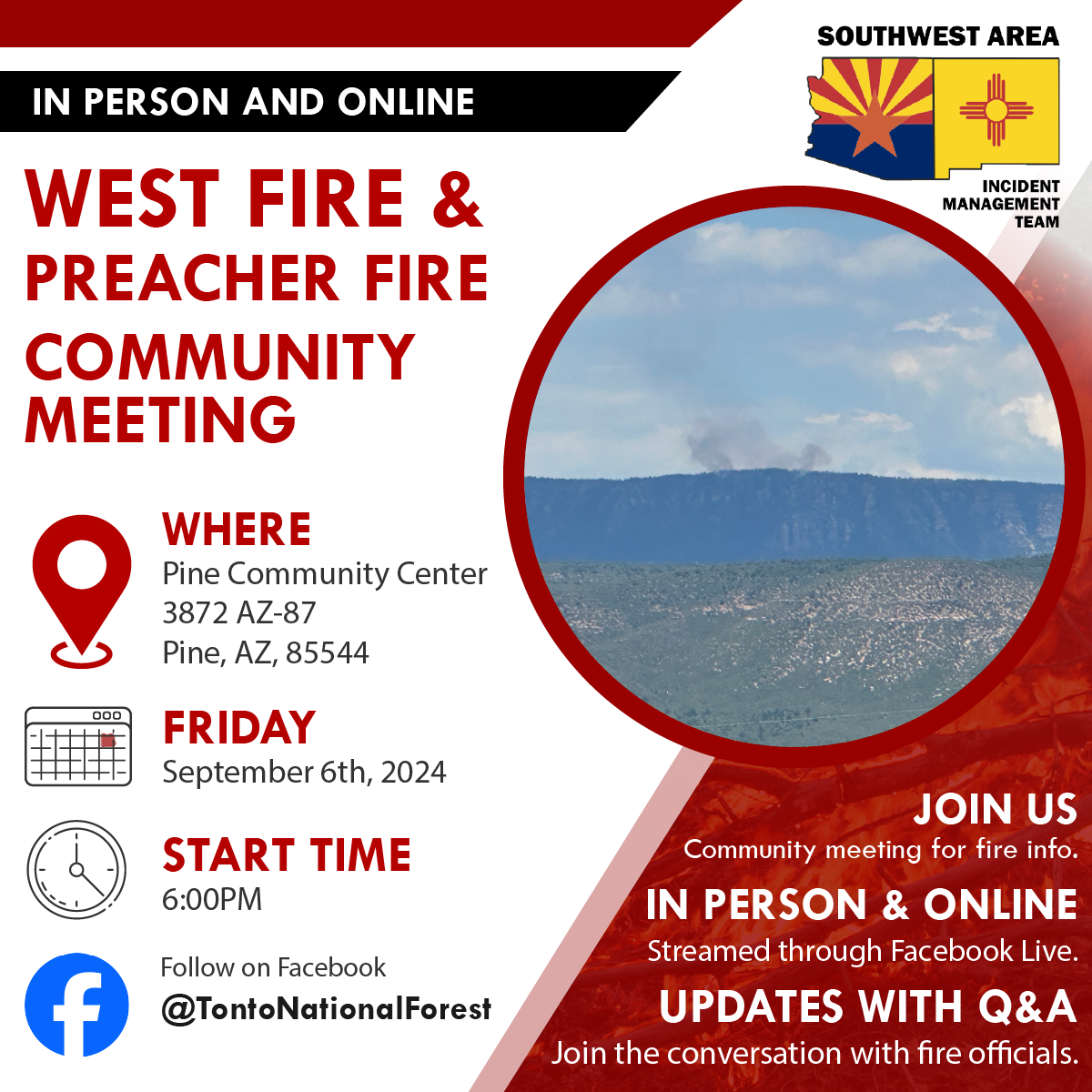
Public Meeting for Friday September 6th in Pine 09 06 2024
Related Incident: 2024 - West Fire - TNF2024 - Preacher Fire - TNF
Publication Type: Announcement
Public Meeting Scheduled for Friday, September 6
The Tonto National Forest and SW Area Incident Management Team will be holding a public meeting on Friday, September 6, 2024 at 6 p.m. at the Pine Community Center 3872 AZ-87, Pine, AZ, 85544.
The public is encouraged to attend either in-person or online on the Tonto National Forest Facebook page (@TontoNationalForest).
Actualizacin del incendio Whisky Creek Sandstone y Blister Creek 5 de septiembre de 2024 09 05 2024
Related Incident: Whisky Creek FireSandstone Fire
Publication Type: News
Tamaño de Whisky Creek: 2,105 acres | Fecha de inicio: 20 de julio |Causa: De orígen humano |Contención 25%
Tamaño de Sandstone: 702 acres | Fecha de inicio: 5 de agosto | Causa: Rayo | Contención 75%
Total de recursos: 381 | Equipos de obreros: 6 | Camiones de bomberos: 6 | Topadoras: 2 | Maquinarias pesadas: 9 | Helicópteros: 3
Los incendios Whisky Creek, Sandstone y Blister Creek arden en un terreno escarpado y accidentado en el Bosque Nacional Mt. Hood, donde los escombros rodantes y los árboles debilitados por el fuego dificultan el trabajo de extinción. Está vigente una advertencia de bandera roja hasta la noche por causa de vientos ráfagas del mar y una baja humedad relativa. Para el viernes y el sábado se prevé una advertencia de calor excesivo.
Whisky Creek:
Los encargados del incendio realizaron un vuelo sobre el incendio y observaron que el fuego creció solo un poco en la bifurcación este de Herman Creek ayer. Se removió manguera excedente de Tomlike Mountain y del extremo noreste del incendio. Las cuadrillas repararon la línea manual y un sitio de aterrizaje temporal para helicópteros. Continuó el trabajo de nivelación a lo largo de la carretera del Servicio Forestal (FSR) 2810. Las aeronaves del incidente dieron su apoyo al incendio Williams Mine hacia el norte al verter agua y realizar vuelos de reconocimiento.
Hoy, las cuadrillas continuarán retirando manguera excesiva de Green Point Mountain y empezarán a reparar una línea de topadoras. Miembros de la cuadrilla de helicópteros comenzarán a construir cargas externas de provisiones y equipos que se sacarán mediante palangre. Se continuará con la nivelación y limpieza de alcantarillas a lo largo de carretera del Servicio Forestal 2810. Se mantendrá una manguera adicional cerca del lago Wahtum como precaución.
Sandstone y Blister Creek:
Los bomberos revisaron un foco de calor en el incendio Blister Creek y vieron que el fuego no tuvo crecimiento ayer. Las maquinarias pesadas continuaron limpiando la carretera del Servicio Forestal 7105 y terminaron de astillar a lo largo de la carretera del Servicio Forestal 7010 en el ramal 150. Las cuadrillas sacaron mangueras de las secciones ya controladas de la línea en la cual no se ha visto calor por muchos días. Llegó una niveladora para comenzar a reparar las carreteras debido al desgaste que hubo por el tráfico de incendios. Hoy, los equipos de bomberos estarán reparando la línea de topadoras, continuarán limpiando, monitoreando, y patrullando los focos de calor.
Clima: Las temperaturas estarán entre los 85 a 80 grados en ambas zonas del incendio hoy. Los vientos soplarán del este 10 a 12 mph, con ráfagas de hasta 15 mph.
Cierres: Los cierres de áreas permanecerán en el Bosque Nacional Mt. Hood, el Área Escénica Nacional Columbia River Gorge y el Condado de Hood River. Para su seguridad, por favor respete las órdenes de cierre del área, así como por la seguridad de nuestros bomberos. Información sobre los cierres se puede ver en https://linktr.ee/whisky_creek.2024.
Seguridad: El público juega un papel importante en la prevención del próximo incendio forestal; tenga cuidado con cualquier posible fuente de incendio. Para obtener consejos de prevención, consulte: https://keeporegongreen.org. La TFR sigue vigente para ambos incendios: https://bit.ly/3T59VWv. Las restricciones contra incendios están vigentes dentro del Bosque Nacional Mt. Hood. Se puede ver más información en: https://www.fs.usda.gov/main/mthood/fire.
Diamond Complex and Middle Fork Fire Update for September 56 2024 09 05 2024
Related Incident: Middle Fork Fire
Publication Type: News
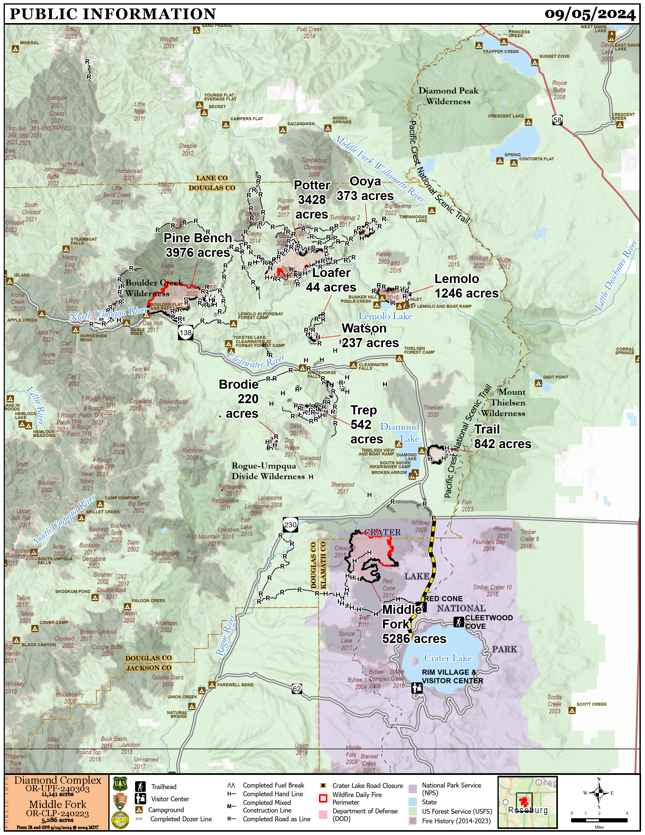
Diamond Complex
- Size: 11,141 acres
- Containment: 81%
- Personnel: 935
- Location: 18 miles SW of Chemult, OR
- Start Date: July 19, 2024
- Cause: Undetermined
Middle Fork Fire
- Size: 5,286 acres
- Containment: 58%
- Personnel: 51
- Location: Crater Lake National Park
- Start Date: July 17, 2024
- Cause: Undetermined
Visitor and Firefighter Safety, Fire Restrictions and Closures
The North Entrance to Crater Lake National Park is closed to all traffic to allow Middle Fork Fire-related hazard reduction work to resume. It will open on Friday afternoon. The park remains open and can be accessed through the South Entrance.
Drivers on Hwy. 230 on the park’s northwest side should be especially cautious. Firefighters are using heavy equipment to remove downed and dead wood in this area. Slow down when approaching firefighter activity. Avoid accidents by driving carefully. Please be patient, minimize distractions and stay focused.
For your safety and ours, do not enter closed areas. Barriers may not block entire roadways to allow for firefighter traffic. However, do not drive around barriers. Areas are closed because of fire activity, falling trees, heavy equipment and road grading. Entering closed areas endangers drivers and firefighters and disrupts important fire-related work.
The Umpqua and Rogue River-Siskiyou National Forests and Crater Lake National Park have different fire restrictions in place. Crater Lake National Park has a fire ban whereas the national forests have Level 2 fire restrictions. Know where you are and follow information posted on their websites.
- Crater Lake National Park: https://www.nps.gov/crla/index.htm
- Umpqua National Forest: https://www.fs.usda.gov/umpqua
- Rogue River-Siskiyou National Forest: https://www.fs.usda.gov/rogue-siskiyou
Current Fire Situation
The warmer, drier weather is intensifying fire activity. However, firefighters increased containment on the Diamond Complex to 81% and on the Middle Fork Fire to 58%. Crews are continuing work to secure the edges of all fires and prepare for and repair areas disturbed by suppression activities. An uncrewed aircraft system (UAS or drone) with infrared capability is being flown over all fires to identify remaining hot spots.
Middle Fork Fire
Firefighters continued to eliminate heat on the fire’s north and east sides. Most heat is well interior where snags present a serious hazard to firefighter safety. Crews continue suppression repair and hauling timber cut during suppression operations along Hwy. 230.
Diamond Complex
- Pine Bench Fire (north of Hwy. 138 near Dry Creek, 3,976 acres, 66% contained): On Tuesday, infrared maps showed no heat indicating firefighters’ successful work. Crews are removing structure protection and excess equipment. They are also repairing areas disturbed by suppression activities.
- Potter Fire (north of Hwy. 138, 2 miles southeast of Potter Mountain, 3,428 acres, 55% contained): Firefighters continue to find heat in heavy duff on the fire’s east side. Helicopters dropped water to cool interior heat where hazard trees prevent ground access. This heat is well inside the current fire footprint and is not a containment threat. Firefighters continue to patrol and secure the fire’s edge. On the southwest side, due to concerns about the possibility of fire moving into dead timber within an old fire scar, crews began using a masticator to create a fuel break.
- Lemolo Fire (north of Lemolo Lake, 1,246 acres, 100% contained): The fire is still showing heat, especially in stumps, big logs and needle cast, but it is well inside the current fire footprint and is not a threat to containment. Firefighters continue to mop up, patrol and monitor.
- Ooya Fire (east of Bug Lake, 373 acres, 100% contained): The fire is still showing heat, but it is well inside the current fire footprint and is not a threat to containment. Crews will patrol and monitor.
- Trail Fire (east of Diamond Lake, 842 acres, 100% contained): Firefighters detected some heat that they worked to eliminate. Crews also began preparing for suppression repair.
Weather and Fire Behavior
Wednesday was the beginning of three days of above normal temperatures and dry conditions which will increase fire activity. Relative humidity fell into the teens and high temperatures hit the low 90s on Wednesday. Near-record heat is expected on Thursday with high temperatures well above normal for Friday as well. Thunderstorms are possible Friday night into Saturday. Sunday and Monday are expected to be seasonably dry and cooler.
Smoke Outlook
Air quality is expected to improve. For more information, visit outlooks.airfire.org/outlook and fire.airnow.gov.
Forest Closure and Fire Restrictions
Umpqua National Forest has decreased Public Use Restrictions to Level 2. The forest remains in High Fire Danger and Industrial Fire Precaution Levels are at Level 2. For more information, visit https://www.fs.usda.gov/alerts/umpqua/alerts-notices/?aid=88996.
Umpqua National Forest’s current closure order allows access to specific roads, trails and campgrounds, which are listed as exemptions in Forest Order 06-15-24-07. For more information, visit https://www.fs.usda.gov/detail/umpqua/news-events/?cid=FSEPRD1202210.
A closure is in place on Rogue River-Siskiyou National Forest for the area north and west of Crater Lake National Park along Hwy. 230 south to the intersection with Hwy. 62. The closure order and a map are available at https://www.fs.usda.gov/alerts/rogue-siskiyou/alerts-notices.
Park Closure and Fire Restrictions
Crater Lake National Park remains open. However, several closures are in effect. For details, visit https://www.nps.gov/crla/planyourvisit/conditions.htm.
The North Entrance to the park is closed to all traffic to allow hazard reduction work related to the Middle Fork Fire to continue. It will reopen on Friday afternoon. The park can be accessed through the South Entrance.
Know before you go. Check the latest conditions and road status before you arrive at your destination to ensure a smooth, enjoyable visit. Updates are available on the park website at https://www.nps.gov/crla and on Oregon Tripcheck at https://www.tripcheck.com.
REMINDER: The Pacific Crest Trail between the Lightning Springs and Rim Trail Intersections, Bald Crater Loop, Bert Creek and Boundary Springs Trails are closed until further notice due to potentially hazardous conditions created by the Middle Fork Fire. Hikers and bikers may not use the North Entrance Road to enter or leave Crater Lake National Park.
Temporary flight restrictions (TFRs)
TFRs are in place over the Middle Fork Fire https://tfr.faa.gov/save_pages/detail_4_8387.html (6 a.m. to 9 a.m. local time to accommodate unmanned aircraft systems work) and https://tfr.faa.gov/save_pages/detail_4_7055.html (9 a.m. to 8 p.m. local time). TFRs are also in place over the Potter and Pine Bench Fires https://tfr.faa.gov/save_pages/detail_4_7055.html (9 a.m. to 8 p.m. local time).
Willamette Complex South Daily Update for Saturday Sept 7th 2024 09 07 2024
Related Incident: Willamette Complex Fires - South
Publication Type: News
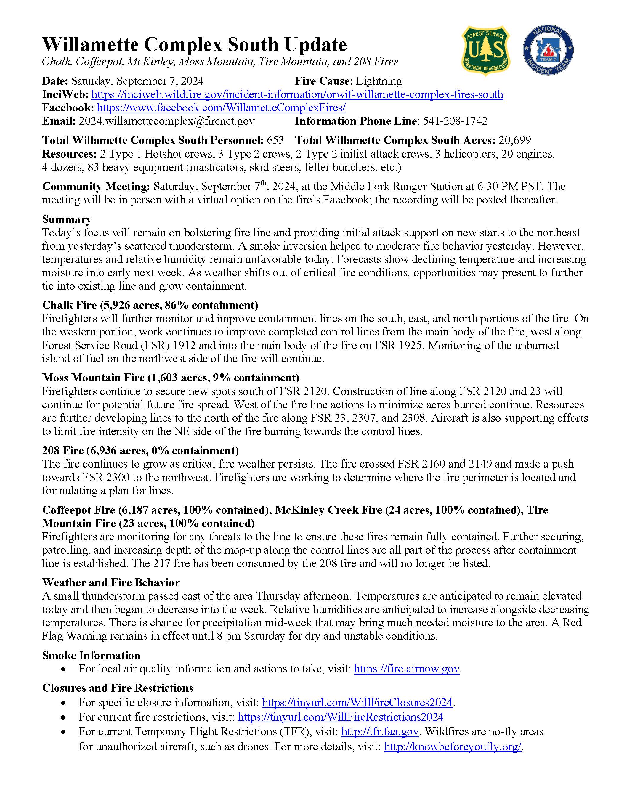
Willamette Complex South Update
Chalk, Coffeepot, McKinley, Moss Mountain, Tire Mountain, 208, and 217 Fires
Online: https://inciweb.wildfire.gov/incident-information/orwif-willamette-complex- fires-south
Facebook: https://www.facebook.com/WillametteComplexFires/
Email: 2024.willamettecomplex@firenet.gov Information Line: 541-208-1742
Saturday, September 7, 2024 Fire Cause: Lightning
Total Willamette Complex South Personnel: 653
Total Willamette Complex South Acres: 20,699
Resources: 2 Type 1 Hotshot crews, 3 Type 2 crews, 2 Type 2 initial attack crews, 3 helicopters, 20 engines, 4 dozers, 83 heavy equipment (masticators, skid steers, feller bunchers, etc.)
Community Meeting: Saturday, September 7th, 2024, at the Middle Fork Ranger Station at 6:30 PM PST. The meeting will be in person with a virtual option on the fire’s Facebook; the recording will be posted thereafter.
Summary
Today’s focus will remain on bolstering fire line and providing initial attack support on new starts to the northeast from yesterday’s scattered thunderstorm. A smoke inversion helped to moderate fire behavior yesterday. However, temperatures and relative humidity remain unfavorable today. Forecasts show declining temperature and increasing moisture into early next week. As weather shifts out of critical fire conditions, opportunities may present to further tie into existing line and grow containment.
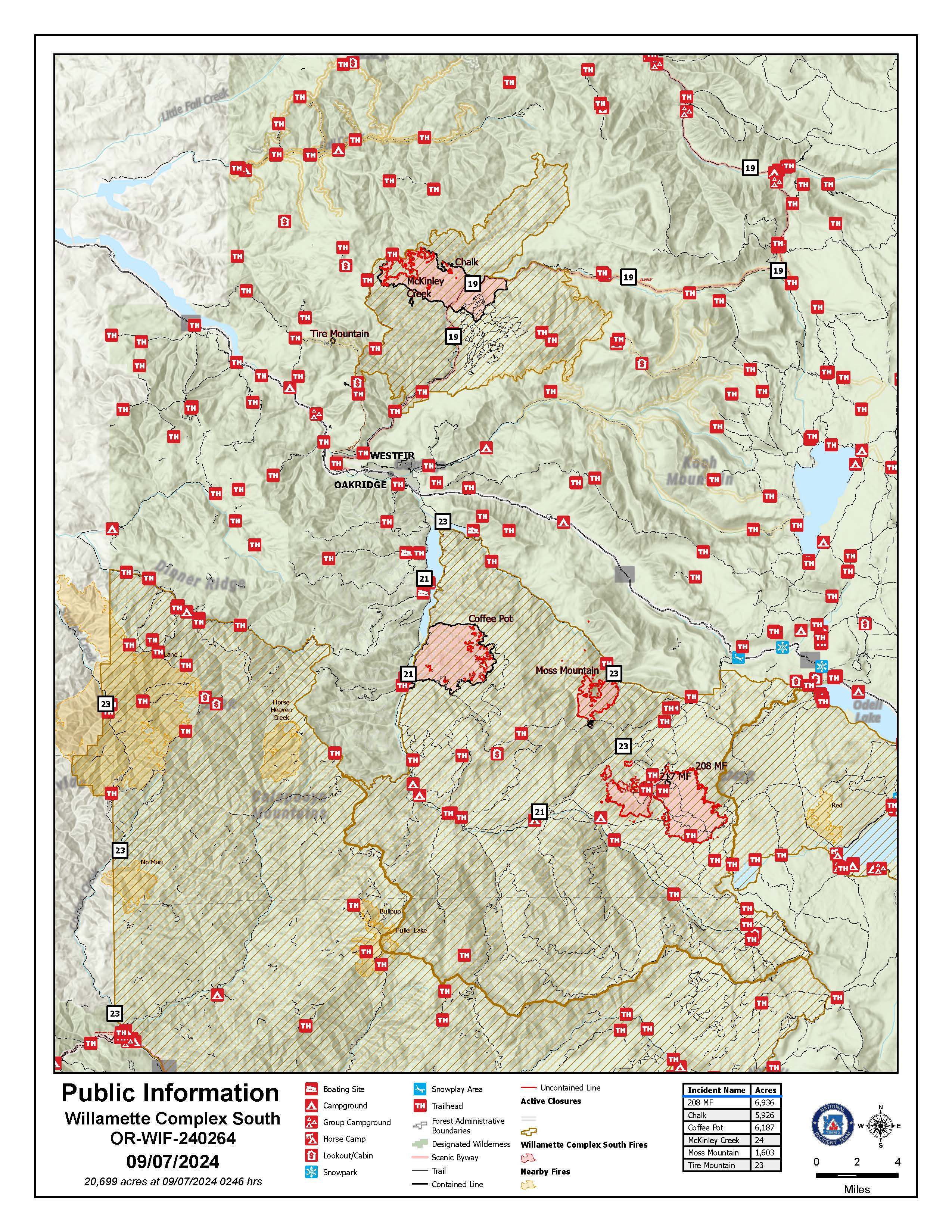
Chalk Fire (5,926 acres, 86% containment)
Firefighters will further monitor and improve containment lines on the south, east, and north portions of the fire. On the western portion, work continues to improve completed control lines from the main body of the fire, west along Forest Service Road (FSR) 1912 and into the main body of the fire on FSR 1925. Monitoring of the unburned island of fuel on the northwest side of the fire will continue.
Moss Mountain Fire (1,603 acres, 9% containment)
Firefighters continue to secure new spots south of FSR 2120. Construction of line along FSR 2120 and 23 will continue for potential future fire spread. West of the fire line actions to minimize acres burned continue. Resources are further developing lines to the north of the fire along FSR 23, 2307, and 2308. Aircraft is also supporting efforts to limit fire intensity on the NE side of the fire burning towards the control lines.
208 Fire (6,936 acres, 0% containment)
The fire continues to grow as critical fire weather persists. The fire crossed FSR 2160 and 2149 and made a push towards FSR 2300 to the northwest. Firefighters are working to determine where the fire perimeter is located and formulating a plan for lines.
Coffeepot Fire (6,187 acres, 100% contained), McKinley Creek Fire (24 acres, 100% contained), Tire Mountain Fire (23 acres, 100% contained)
Firefighters are monitoring for any threats to the line to ensure these fires remain fully contained. Further securing, patrolling, and increasing depth of the mop-up along the control lines are all part of the process after containment line is established. The 217 fire has been consumed by the 208 fire and will no longer be listed.
Weather and Fire Behavior:
A small thunderstorm passed east of the area Thursday afternoon. Temperatures are anticipated to remain elevated today and then began to decrease into the week. Relative humidities are anticipated to increase alongside decreasing temperatures. There is chance for precipitation mid-week that may bring much needed moisture to the area. A Red Flag Warning remains in effect until 8 pm Saturday for dry and unstable conditions.
Smoke Information
For local air quality information and actions to take, visit: https://fire.airnow.gov.
Closures and Fire Restrictions
For specific closure information, visit: https://tinyurl.com/WillFireClosures2024.
For current fire restrictions, visit: https://tinyurl.com/WillFireRestrictions2024
For current Temporary Flight Restrictions (TFR), visit: http://tfr.faa.gov. Wildfires are no-fly areas for unauthorized aircraft, such as drones. For more details, visit: http://knowbeforeyoufly.org/.
Closures and Fire Restrictions
- For specific closure information, visit tinyurl.com/WillFireClosures2024
- For current fire restrictions, visit tinyurl.com/WillFireRestrictions2024
- Temporary Flight Restrictions (TFR): tfr.faa.gov for up-to-date areas. Wildfires are a no-fly zone for unauthorized aircraft, including drones. For more information, visit knowbeforeyoufly.org.
RailroadDaly update September 5 2024 09 05 2024
Related Incident:
Publication Type: News
Railroad-Daly update September 5, 2024
Location: Railroad Creek/ Skalkaho Creek confluence, 26 miles SE of Hamilton
Start Date: 7/25/2024
Cause: Lightning
Size: 362 acres for Railroad & 1,670 acres for Daly
18 Total Personnel
KEY MESSAGE
A portion of Skalkaho Hwy (Hwy 38) is closed to traffic (see details below). There is a temporary flight restriction in place over the fire area.
CURRENT STATUS
The Railroad fire is currently 362 acres, and the Daly fire is 1,670 acres. Because of the steep and difficult terrain and high risk to responders, suppression actions have been limited. One of the main objectives is identifying any values at risk, and protecting those, while protecting the public and keeping firefighters safe. Yesterday, crews finished wrapping the Gird Point Lookout tower and will continue snagging operations along Hwy 38 to ensure the road is safe for traffic. On the north side of Hwy 38 crews have started identifying areas where handline can be constructed to slow the fire’s path.
WEATHER
A ridge of high pressure is building over the region, lasting through early next week. Temperatures will trend warmer with a return of intense thermal belts. A few showers and thunderstorms are possible by Sunday afternoon. Long term models show the ridge will most likely break down next week.
CLOSURES
Because the Daly Fire exhibited increased fire behavior late on Monday night with fire crossing over the Skalkaho Hwy (Highway 38), an expanded Road Closure is in effect from Black Bear Campground on Skalkaho Hwy (Hwy 38) to the Skalkaho Pass. There are barricades in place, and Gird Point Lookout is closed.
See InciWeb for map and details on area closure: https://inciweb.wildfire.gov/incident-closures/mtbrf-railroaddaly-fire
Limepoint Fire Daily Update September 17 2024 09 17 2024
Related Incident: Limepoint Fire
Publication Type: News
Limepoint Fire
Tuesday, September 17, 2024
Contacts for Fire Information:
208-992-3032 or 2024.limepoint@firenet.gov
https://inciweb.wildfire.gov/incident-information/idpaf-limepoint-fire
https://www.facebook.com/payettenationalforest/
Today marks the last full workday for the FDNY Incident Management Team on the Limepoint Fire. Effective tomorrow, Wednesday September 18, 2024, management of this fire will be given back to the Payette National Forest. However, fire crews will continue to patrol the north-eastern fire perimeter, and the fire will remain in a patrol and monitor status for quite some time. The rain from last night and throughout today is a welcome relief to the dry conditions throughout the Great Basin Area.
This will be the last update posted in Cuprum and Bear. The fire information phone number and email have been discontinued. All phone calls with questions and concerns should be made to the Payette National Forest at (208) 634-0700.
As the FDNY IMT returns management of the fire back to the Payette National Forest, we also prepare to depart this beautiful area of western Idaho. Since July 24, your small rural towns have been taken over by fire crews and large equipment. As the dust settles and the sights and sounds fade, we thank you for your patience and support. Even after the damage the Limepoint Fire caused, the beauty of the area was on full display. The forest will replenish its growth, the wildlife will return, and we will forever remember our experience here in the Payette National Forest.
For your own safety, please continue to observe all forest closure notices and watch out for fire personnel and apparatus around the fire area throughout the rest of the fall.
Evacuations: Cuprum remains at a Level 1 (READY) evacuation level.
Closures: For details about the closure, visit https://www.fs.usda.gov/alerts/payette/alerts-notices. For your safety and the safety of firefighters. Please observe the existing Payette Forest Closures that are still in effect and watch out for firefighters and fire traffic.
Restrictions: The following counties in western Idaho have conditional burning restrictions: Washington, Payette, Gem, Boise, Custer and Elmore. For more information please visit: https://www2.deq.idaho.gov/air/aqipublic/map/outdoorburn.
Even in areas without restrictions, everyone is reminded to be extremely cautious with use of outdoor fires.
Park Fire Daily Update 09 05 2024
Related Incident: Park Fire
Publication Type: News
Park Fire Update: Thursday, September 5, 2024
Southwest Complex Incident Management Team 2
Incident Commander John Truett
Size: 429,603 acres
Start Date: July 24, 2024
Containment: 99 percent
Total Personnel: 743
Resources: 1 helicopter, 14 crews, 13 engines, 15 dozers, 31 water tenders, 6 masticators, 7 chippers, 22 excavators, 9 feller bunchers, 12 skidsteers, 3 log loaders, 1 processor, 1 backhoe, 5 road graders
CURRENT SITUATION: During fire suppression, the size, weight and quantity of vehicles traveling forest roads can cause damage to the road surface. Part of the repair process involves resurfacing these roads so they do not pose a risk to people using them when the forest closure is lifted. The roads group is also improving Ponderosa Way and adjacent roads to facilitate the movement of mechanical harvesting equipment that is part of the hazard-tree group. That group is using equipment and tree-felling crews to cut dead trees along roadsides, and they are either chipping, lopping and scattering branches; creating piles to be burned later; or decking logs to remove heavy fuels. View photos and videos of firefighters and equipment doing repair work on the Lassen National Forest Facebook page: facebook.com/LassenNF.
WEATHER & FIRE SAFETY: Temperatures will continue to rise into the weekend. A heat advisory below 3,500 feet exists through Friday. No significant precipitation is forecast, and humidities remain extremely low. Isolated stump holes, logs and snags in the fire boundary will continue to produce visible smoke until a season-ending weather event. This minimal smoldering does not pose a threat to containment lines. A local fire crew is assigned to the incident and specifically tasked with locating and extinguishing isolated hotspots. Outside the fire perimeter, fuel load, including grass, brush and timber, is very dry and ready to burn. Any new fires would be difficult to control. Continue to be diligent as you work and recreate outside, and be aware of current fire restrictions.
FIRE RESTRICTIONS: Know before you go! Fire restrictions are in effect within the Lassen National Forest. For details, view Forest Order No. 06-24-04 here: fs.usda.gov/alerts/lassen/alerts-notices. Find links to other land management agencies’ fire restrictions in the Park Fire Information Linktree (URL and QR code below).
FOREST CLOSURE: Lassen National Forest lands, roads, and trails near the fire are temporarily closed. Individuals are responsible for knowing where they are in relation to the closure area. Keep our firefighters and yourselves safe by abiding by the closure order. If you are recreating on your public lands, be prepared and view Forest Order No. 06-24-07 and map here: fs.usda.gov/alerts/lassen/alerts-notices.
![]() Park Fire Information (Southwest CIMT 2): 530-414-9298 | 2024.park@firenet.gov
Park Fire Information (Southwest CIMT 2): 530-414-9298 | 2024.park@firenet.gov
Park Fire Information (CAL FIRE): 530-529-9233
Park Fire Linktree (fire information website links): linktr.ee/park_fire
Actualizacin Sobre Incendio Park Jueves 5 de Septiembre de 2024 09 05 2024
Related Incident: Park Fire
Publication Type: News
Actualización Sobre Incendio Park: Jueves, 5 de Septiembre de 2024
Administración De Incidentes Complejos Del Área Suroeste - Equipo 2
John Truett - Comandante Del Incidente
Tamaño: 429,603 acres
Fecha de Inicio: 24 de Julio de 2024
Contencion: 99%
Personal Total: 743
Recursos: 1 helicóptero, 14 cuadrillas, 13 camiones de bomberos, 15 topadoras, 31 camiones de agua, 6 masticadoras, 7 astilladoras, 22 excavadoras, 9 máquinas para talar árboles, 9 apiladoras, 12 minicargadoras, 3 cargadores de troncos, 1 procesador, 1 retroexcavadora, 5 motoniveladoras
SITUACIÓN ACTUAL: Durante la extinción de incendios, el tamaño, el peso y la cantidad de vehículos que circulan por caminos forestales pueden causar daños a la superficie de la carretera. Parte del proceso de reparación implica repavimentar estos caminos para que no representen un riesgo para las personas que los usan cuando se levante el cierre del bosque. El equipo de caminos también está mejorando Ponderosa Way y los caminos adyacentes para facilitar el movimiento de equipos mecánicos de cosecha que forman parte del equipo de árboles peligrosos. Ese grupo está utilizando equipos de tala de árboles para cortar árboles muertos a lo largo de las carreteras, y están picando, podando y esparciendo ramas; crear montones para quemarlos más tarde; o troncos de terrazas para eliminar combustibles pesados. Vea fotos y videos de bomberos y equipos realizando trabajos de reparación en la página de Facebook del Bosque Nacional Lassen: facebook.com/LassenNF.
CLIMA Y SEGURIDAD CONTRA INCENDIOS: Las temperaturas seguirán aumentando hasta el fin de semana. Existe un aviso de calor por debajo de 3,500 pies hasta el viernes. No se pronostican precipitaciones significativas y la humedad sigue siendo extremadamente baja. Los tocones, troncos y troncos aislados en el límite del incendio seguirán produciendo humo visible hasta que llegue un evento climático que ponga fin a la temporada. Esta combustión mínima no representa una amenaza para las líneas de contención. Un equipo de bomberos local está asignado al incidente y tiene la tarea específica de localizar y extinguir los puntos críticos aislados. Fuera del perímetro del incendio, la carga de combustible, incluyendo pasto, maleza y madera, está muy seca y lista para quemarse. Cualquier nuevo incendio sería difícil de controlar. Continúe siendo diligente mientras trabaja y se recrea al aire libre, y tenga en cuenta las restricciones actuales contra incendios.
RESTRICCIONES DE INCENDIO: ¡Infórmate antes de ir! Hay restricciones contra incendios vigentes dentro del Bosque Nacional Lassen. Para más detalles, consulte la Orden Forestal No. 06-24-04 aquí: fs.usda.gov/alerts/lassen/alerts-notices. Encuentre enlaces a las restricciones de incendios de otras agencias de administración de tierras en el árbol de enlaces de información sobre el incendio Park (URL y código QR a continuación).
CIERRE DE BOSQUES: Los terrenos, caminos y senderos del Bosque Nacional Lassen cerca del incendio están cerrados temporalmente. Las personas son responsables de saber dónde se encuentran en relación con el área de cierre. Mantenga a nuestros bomberos y a usted mismo seguros cumpliendo con la orden de cierre. Si está recreando en sus tierras públicas, prepárese y vea la Orden Forestal No. 06-24-07 y el mapa aquí: fs.usda.gov/alerts/lassen/alerts-notices.
![]() Información sobre incendio Park (Suroeste CIMT 2) 530-414-9298 2024.park@firenet.gov
Información sobre incendio Park (Suroeste CIMT 2) 530-414-9298 2024.park@firenet.gov
Información sobre incendio Park (CAL FIRE): 530-529-9233
Árbol de Enlace Incendio Park (facebook.com/LassenNF (enlaces de información):
Septmber 5 2024 Red Fire Daily Update 09 05 2024
Related Incident: Red Fire
Publication Type: News
Size: 877 acres Location: 5 miles west of Crescent Lake Junction, OR County: Klamath
Start Date: July 17, 2024 Cause: Lightning Containment: 0% Total Personnel: 115
Activities – The size of the fire remains at 877 acres. The continued warm and dry weather has contributed to an increase in fire activity mostly in the interior of the fire footprint. Today work along the shaded fuel break will continue with chip, slash, and log removal. Yesterday, firefighters tested the 1.5-mile hose lay along Whitefish Creek Trail that is in place to check fire spread as it approaches the trail. Additional structure protection equipment remains in place along Crescent Lake and is periodically being tested. Firefighters predict that the Red Fire will remain on the landscape until the area experiences significant rain or snow this fall.
Closures – To provide for the safety of firefighters, equipment operators, and the public, the Deschutes National Forest emergency closure around Crescent Lake and in the Diamond Peak Wilderness is still in effect. Forest Service Road 60 is closed, and road guards have been posted for public safety. The emergency closure is being reevaluated daily as conditions continue to change. More closure information is available at: https://www.fs.usda.gov/alerts/deschutes/alerts-notices/?aid=89091.
The Pacific Crest Trail (PCT) is closed from north of Windigo Pass (Mile 1883.5) to Highway 58 (Mile 1909.5). The previous PCT detour around the fire has been decommissioned as of noon on September 4. Currently there is not a detour around the closure. A map displaying the PCT closure can be viewed on the Pacific Crest Trail Association’s (PCTA) website at: https://closures.pcta.org/closure/Mr02blDvEwX1SJ9h1H49.
The 2024 season for commercially harvesting Matsutake mushrooms opened for the Deschutes National Forest this week and will close November 4, 2024. A commercial permit must be purchased for the picking of any Matsutake mushrooms on National Forests that are harvested for resale. The emergency fire closure impacts certain harvesting locations.
Incident Weather, Fire Behavior, and Smoke – A warming and drying trend has returned this week with temperature and relative humidity reaching critical values. Temperatures will continue to be warm at 80 to 85 degrees and relative humidity is forecasted to reach 15% to 20% during the day. A light east wind will reduce overnight humidity recovery further contributing to drier conditions. These conditions will persist into the weekend. New fires are the source of most of the smoke in the area.
Strategy – A full suppression strategy is being implemented utilizing indirect tactics, shaded fuel breaks, structure protection equipment, trails, and hose lays. When the fire started, an assessment by the initial attack incident commander, local fire managers and forest staff determined the risk to responders was too great to continue with direct attack due to a lack of escape routes and safety zones, snag hazards, and firefighter safety issues in the remote location. Firefighters are continually reevaluating the safest, most effective suppression strategy based on changing weather, fuel conditions, and fire behavior. Firefighter and public safety remain the incident management team’s highest priority in managing this fire. Expect to see increased fire activity due to the warmer and drier conditions.
Evacuations – The WILDFIRE! Level 1 – BE READY to Evacuate notice issued by Klamath County Emergency Management for Crescent Lake, Odell Lake, and Crescent Junction areas remains in effect (INCENDIO FORESTAL! Nivel 1 - ESTÉ PREPARADO para evacuar de las siguientes zonas: Crescent Lake, Odell Lake, Crescent Junction). Visit www.klamathcounty.org/300/emergency-management for more information or to sign up for alerts.
Fire Restrictions – Stage 2 Public Use Fire Restrictions – which prohibit open fires, including in developed campgrounds – remain in effect for the Deschutes National Forest. The Industrial Fire Precaution Level is currently Level III “Partial Shutdown.” Visit fs.usda.gov/detail/deschutes/home/?cid=stelprdb5297376 for more information.
West Preacher Fires Update 09 05 2024
Related Incident: 2024 - Preacher Fire - TNF2024 - West Fire - TNF
Publication Type: News
Public Meeting scheduled for Friday, September 6
Highlights: The Tonto National Forest and SW Area Incident Management Team will be holding a public meeting on Friday, September 6, 2024 at 6 p.m. at the Pine Community Center 3872 AZ-87, Pine, AZ, 85544.
Operations:
West Fire -24 Acres: No significant growth was observed overnight. Today firefighters and equipment will focus on removing fuels along Forest Service Road (FSR) 218. Dead trees are being cut along the Milk Ranch Road (FSR218). Masticators and dozers are also working along portions of FSR 300. Additional control lines are being scouted in Bray Creek Ranch and Camp Geronimo. Dozers are improving existing fuel breaks west of Pine.
Preacher Fire - 2 Acre: The Preacher Fire is burning about 8 miles northeast of Payson, Arizona. The fire is burning within an area previously prepared for prescribed burning. Today engines are patrolling the existing control lines and checking for any improvements needed. Sparse vegetation that re-grew along portions of the previously constructed lines will be removed in preparation for firing operations.
Both fires are being managed under a confine/contain strategy with the goal of reintroducing fire into a fire dependent ecosystem. The intended result of managing naturally caused fires are to reduce hazardous fuels, encourage the growth of native forage, improve range conditions, increase species diversity, protect and improve wildlife habitat, improve watershed conditions and restore ecological balance. The total planning areas for the West Fire includes 16,700 acres, for Preacher Fire 3,200 acres. This will decrease unnaturally high accumulations of fuels and the potential for future fires to burn with unnaturally high severity, aligning with the Forest Service Wildfire Crisis Strategy.
Weather: Sunny and hot conditions persist with temperatures in the middle to upper 80’s. The relative humidity has fallen to around 20% and the wind is terrain driven at speeds less than 10 mph with gusts to 15 mph. The overall weather pattern will not change through the end of the week with hot and dry conditions. Low shower and thunderstorm chances are anticipated to return to the region on the weekend.
Safety: The health and safety of firefighters and the public are always the first priority. Members of the public are asked to avoid the fire area while fire operations are being conducted.
Smoke: Smoke from the West and Preacher Fires may be visible in the surrounding areas for many days. Smoke will be heavier in the mornings as it settles into the lower elevations and will lift as temperatures increase. As temperatures increase the volume of smoke may increase due to the drying and ignition of available fuels. Smoke-sensitive individuals and people with respiratory problems or heart disease are encouraged to take precautionary measures. Learn more about smoke impacts on the Arizona Department of Environmental Quality website.
For the latest news and information about the Tonto National Forest, follow along on Facebook @TontoNationalForest, ‘X’ (formerly Twitter) @TontoForest or Instagram @tontonationalforest and on the Tonto National Forest website.