
Incident Publication
House Draw Fire Daily Update for September 3 2024 09 03 2024
Related Incident: House Draw Fire
Publication Type: News
Hot, dry conditions continue as crews make steady progress on suppression repair
Daily Update September 3, 2024
Fire Information Phone: 307-201-3885 (8 a.m. – 8 p.m.)
Media Information Phone: 307-543-7202 (8 a.m. – 8 p.m.)
Suppression Repair Phone: 307-303-7642 (8 a.m. – 8 p.m.) This phone line is for private landowners to contact fire officials with repair of heavy equipment line or cut fence that occurred during suppression efforts. Please be aware that this phone line will be unstaffed starting Wednesday, September 4, 2024, at 8:00 p.m.
Email: 2024.housedraw@firenet.gov
Acres: Flat Rock – 52,421; Remington – 196,368; Constitution – 24,630; House Draw – 174,547; Silver Spoon – 1,721
Acreage changes may occur due to overnight operations and infrared mapping.
Containment: Flat Rock – 78% Remington – 86%; Constitution – 95%; House Draw – 94%; Silver Spoon – 0%
Location: Flat Rock – 11 miles northwest of Gillette, WY; Remington – 14 miles northeast of Leiter WY, multiple counties in southeast MT; Constitution – 11 miles northeast of Gillette, WY; House Draw – 9 miles southeast of Buffalo, WY; Silver Spoon – 37 miles north of Gillette, WY
Start Date: August 21, 2024 Personnel: 547 Fuels: Grass, brush and timber
Resources: 10 crews | 57 engines | 14 water tenders | Heavy Equipment
Highlights: Thanks to the hard work of firefighters, crews and heavy equipment on the Flat Rock, Remington, Constitution, House Draw and Silver Spoon fires, approximately 212 miles of fireline has been repaired to date.
Fire Activity: The fire area will experience hot, dry conditions again today, increasing the potential for new starts. Additionally, smoke may be visible as unburned fuels within the interior of containment lines ignite, primarily in cottonwood stands, juniper drainages and pockets of pines.
Silver Spoon – Firefighters on the Silver Spoon Fire patrolled the area yesterday, September 2, to identify heat sources after conducting burn operations on Sunday night. Today, crews will scout critical holding points, secure the perimeter and begin mop-up.
Flat Rock – Heavy equipment repaired line from the north end of the Flat Rock Fire, south along the perimeter. Additional resources worked from the eastern perimeter, into the interior of the fire, also moving south. Today, crews will continue suppression repair activities including fence repair, where needed.
Remington – Crews worked to secure containment lines and mop-up hot spots on the Remington Fire yesterday while heavy equipment conducted suppression repair. Heavy equipment operators repaired fireline on the Wyoming side of the fire as well as along the southwestern perimeter. Bulldozers worked along the northwest portion of the fire, below Birney, MT, and hand crews secured line where needed. Today, heavy equipment and crews will build on the yesterday’s efforts, building water bars on the east portion of the fire near Poker Jim and moving into their interior.
Constitution – Yesterday, graders worked north to south on the Constitution Fire. Today, hotshots and a hand crew will continue securing line on the eastern and northern edges of the fire area.
House Draw – Hand crews worked on the south end of the House Draw Fire yesterday while heavy equipment made progress along the I-90 corridor. Today, crews will continue suppression repair work as graders and other heavy equipment move to the north side of the interstate.
Evacuations: An evacuation order is in effect for Bitter Creek Road area in northern Campbell County due to the Silver Spoon Fire. Additional information available at www.campbellcountywy.gov/AlertCenter.aspx?AID=Evacuation-For-the-Bitter-Creek-Road-Are-98.
Weather: Record breaking temperatures were recorded in Sheridan (101 degrees) and Gillette (99 degrees) yesterday. A Red Flag warning is in effect today. The fire area will also see scattered thunderstorms with limited precipitation and gusty outflow winds. Temperatures will remain in the low 90s.
Fire Restrictions and Closures: Fire Restrictions are in place across the fire area including:
- The Custer Gallatin National Forest (Powder River and Rosebud Counties, Montana) implemented road closures within the Remington Fire burned area located on National Forest System lands, effective August 30, 2024. More information available at https://www.fs.usda.gov/Internet/FSE_DOCUMENTS/fseprd1202405.pdf.
- Stage 1 Fire Restrictions for Custer Gallatin National Forest, Ashland Ranger District (effective August 1, 2024). More information available at https://www.fs.usda.gov/alerts/custergallatin/alerts-notices/?aid=89447.
- Stage 1 Fire Restrictions for Bureau of Land Management Buffalo Field Office in Johnson County (as of July 1, 2024) and Campbell and Sheridan Counties (as of July 9, 2024). More information available at https://www.blm.gov/programs/public-safety-and-fire/wyoming/fire.
- Stage 1 Fire Restrictions for Sheridan, Campbell and Johnson Counties in Wyoming (as of July 9, 2024). More information available at https://wsfd.wyo.gov/fire-management/fire-restrictions.
- Stage 1 Fire Restrictions for Thunder Basin National Grasslands within the Douglas Ranger District in Converse, Campbell, Crook, Natrona, Niobrara, Platte, and Weston counties in the State of Wyoming (as of August 7, 2024). More information available at https://www.fs.usda.gov/detail/mbr/news-events/?cid=FSEPRD1199001.
- The Medicine Bow-Routt National Forest implemented a temporary closure of the popular Weston Recreation Area on the Thunder Basin National Grasslands within the Constitution Fire (Johnson County, WY), effective August 23, 2024. More information available at https://www.fs.usda.gov/Internet/FSE_DOCUMENTS/fseprd1201513.pdf.
More Information:
InciWeb (House Draw Fire): https://inciweb.wildfire.gov/incident-information/wyhpd-house-draw-fire
InciWeb (Remington Fire): https://inciweb.wildfire.gov/incident-information/mtgnf-remington-fire
Public Information Linktree: https://linktr.ee/housedrawfire
Facebook: https://www.facebook.com/SWIMT5/
Copperfield Fire Evening Update for 922024 09 03 2024
Related Incident: Copperfield Fire
Publication Type: News
Copperfield Fire Evening Update for Monday, September 2nd - 8PM
Monday, September 2nd was a day of transition on the Copperfield Fire. Oregon Department of Forestry’s Incident Management Team 3 and Oregon State Fire Marshal Red Incident Management team are currently managing the fire under unified command as of 6 pm this evening. The fire grew to an estimated 3,241 acres, driven by strong afternoon winds. Fire growth, which occurred mainly on the western flank of the fire, resulted in new spot fires up to half a mile.
Fire crews worked with heavy equipment operators to put in and solidify dozer line on the east and north end of the fire. As those lines were solidified throughout the day, they continued to hold in part due to fuels treatments completed along the east flank of the current fire footprint, and crews have been mopping up to extinguish hot spots. On the west flank of the fire, fire crews were challenged by changing wind direction and active fire behavior.
Firefighters from across the state continue to arrive to battle the blaze and were supported by a half dozen aircraft. The focus for tonight’s night operations is to take advantage of low temperatures and high humidity to solidify the containment lines established today. Crews are focused on preserving life and property and keeping the current fire footprint as small as possible to minimize impacts to timber, rangeland, and cultural sites.
Residents and visitors in the area are advised to stay safe and stay informed. Visit https://www.klamathcounty.org/300/Emergency-Management for up-to-date information on evacuations and evacuee resources. A road closure remains in effect on the Sprague River Highway between mile markers 5 and 15. More information will continue to be posted and shared to this Facebook page.
Per the Klamath County Sheriff's Office, evacuation levels will be reassessed the morning of September 3rd. Any changes will be published first to Genasys Protect, then by Mass Notification, then to the Klamath County Common Operating Picture (COP) - https://www.klamathcounty.org/300/Emergency-Management
A road closure remains in effect on the Sprague River Highway between mile markers 5 and 15.
US26287 Closed to Public Travel due to Fish Creek Fire 09 02 2024
Related Incident:
Publication Type: Announcement
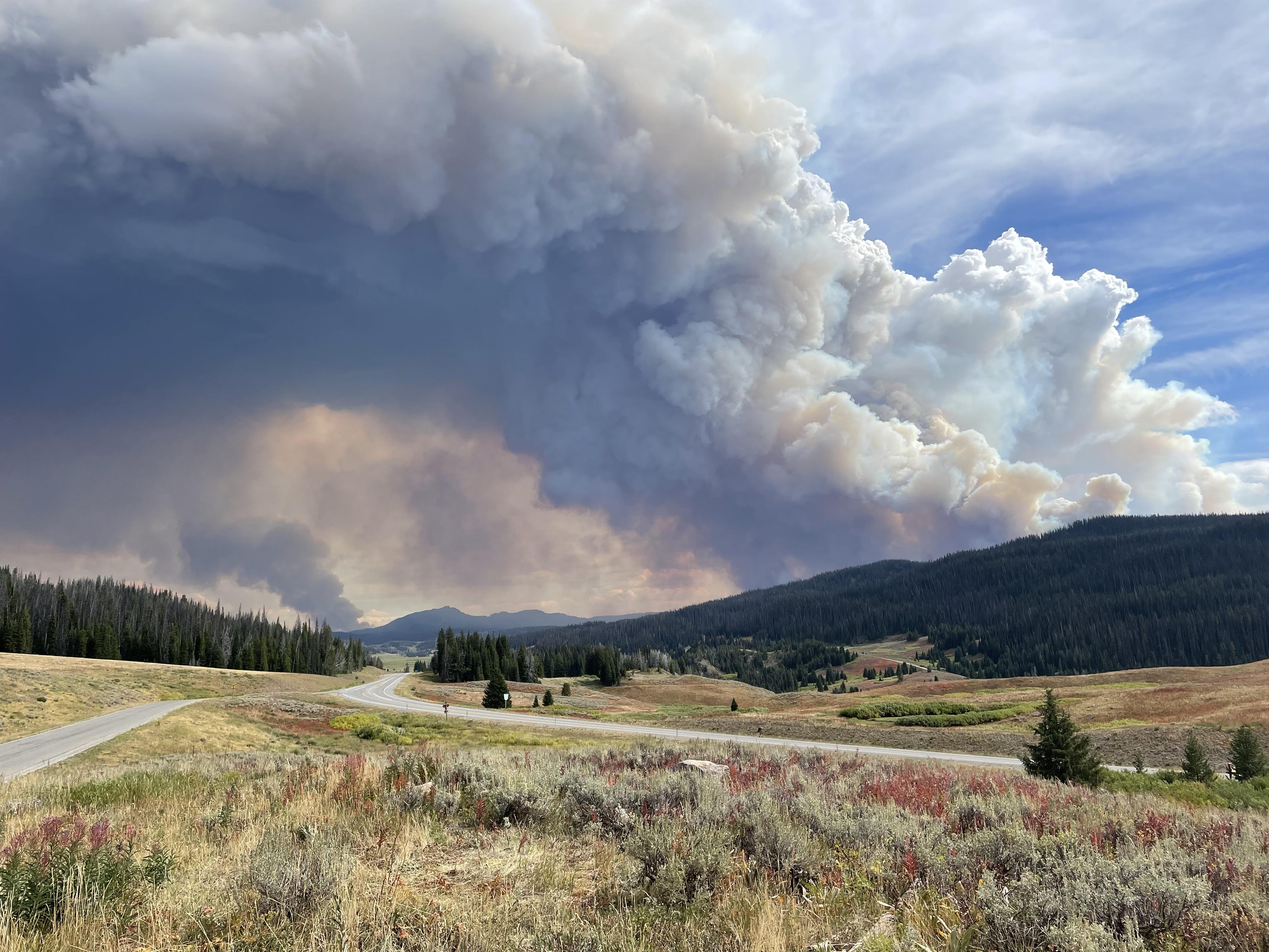
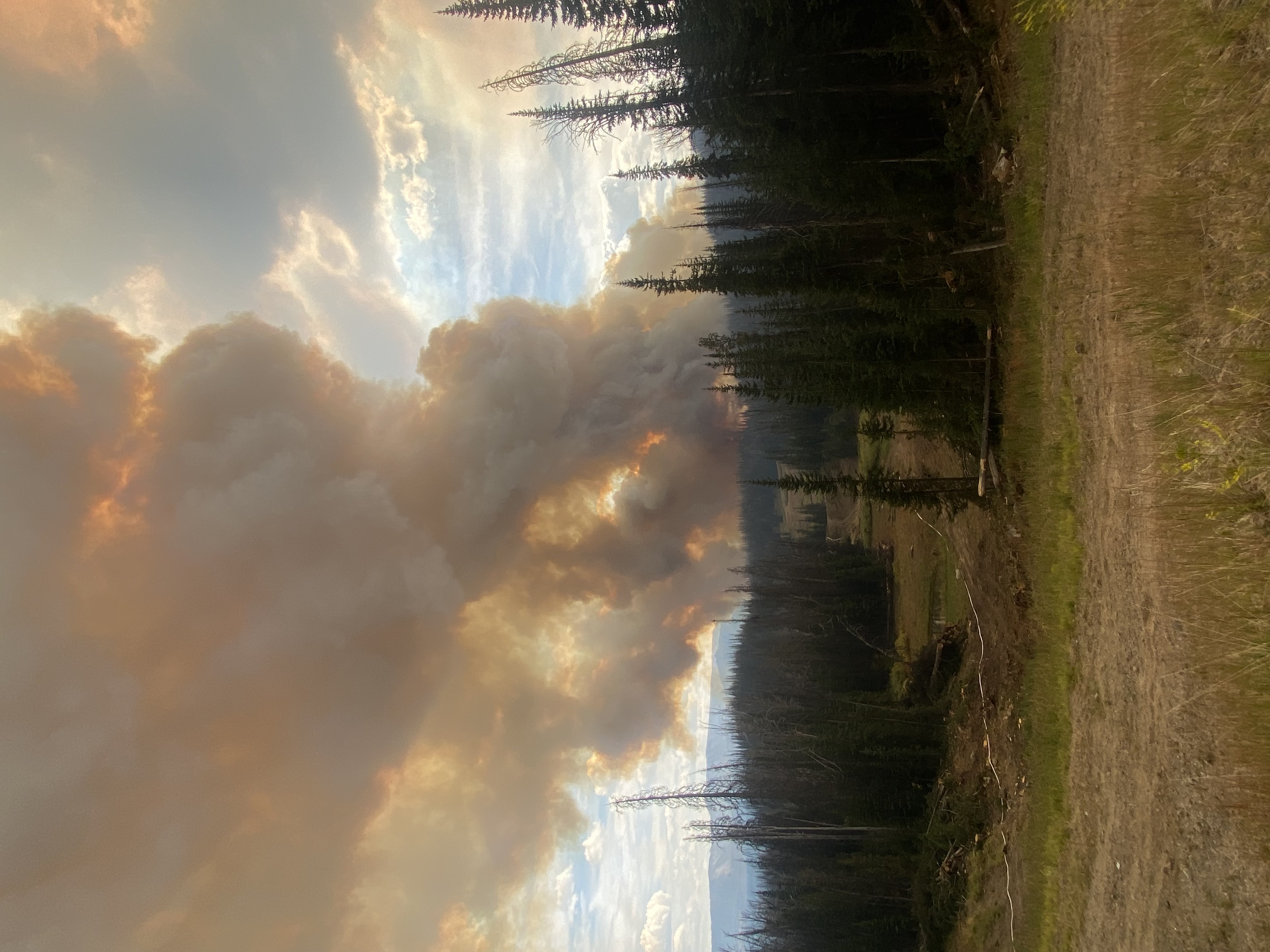
The Wyoming Department of Transportation will close US26/287 west of Dubois about 4 pm today due to excessive smoke and limited visibility near the Fish Creek Fire on Togwotee Pass.
As of this morning, more than 15,500 acres had burned on the Fish Creek Fire. The fire has been very active today and continues to burn in a northeast direction. Hot winds, low humidity and higher-than-normal temperatures are helping the fire to advance near to US26/287 (Togwotee Pass).
The duration of the highway closure is not known at this time. If you’re able, make alternative travel plans. For road conditions, please go to wyoroad.info.
Wyoming Travel Information Map (wyoroad.info)
or
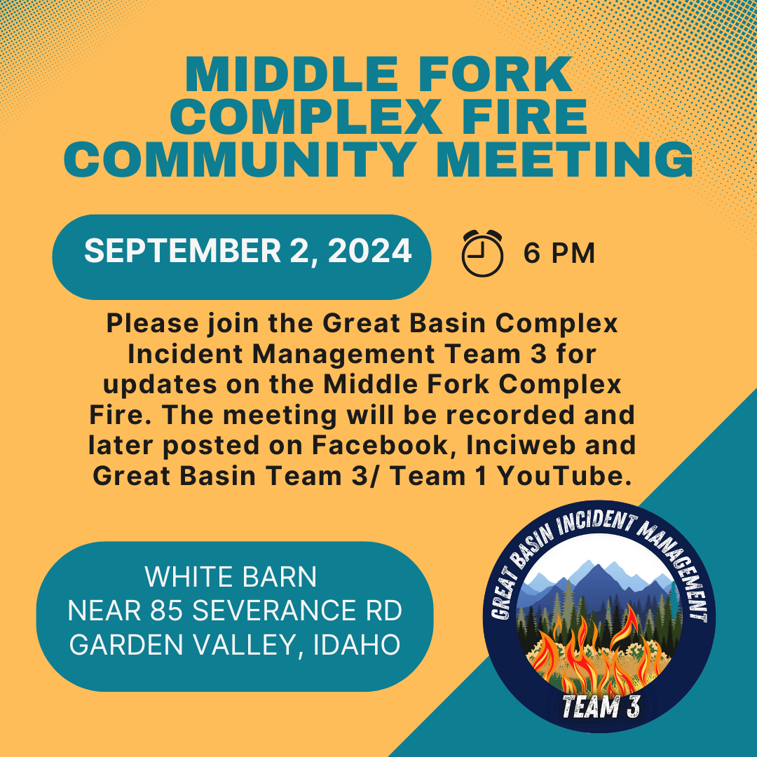
Middle Fork Complex Community Meeting Today 09 02 2024
Related Incident:
Publication Type: Announcement
Please join the Great Basin Complex Incident Management Team 3 today at 6 pm at the white barn building near 85 Severance Road, Garden Valley, Idaho for updates on the Middle Fork Complex Fire. The meeting will be recorded and later posted on Facebook and Great Basin Team 3/ Team 1 YouTube.
Park Fire Traffic Safety Reel 09 02 2024
Related Incident: Park Fire
Publication Type: Announcement
Clink Link below to view Traffic Safety Reel.
Park Fire Traffic Safety Post 09 02 2024
Related Incident: Park Fire
Publication Type: Announcement
Click Link Below to View Park Fire Traffic Safety Video...
Actualizacin del incendio Whisky Creek Sandstone y Blister Creek 09 02 2024
Related Incident: Whisky Creek FireSandstone Fire
Publication Type: News
Tamaño de Whisky Creek: 2,092 acres | Fecha de inicio: 20 de julio |Causa: De orígen humano |Contención 25%
Tamaño de Sandstone: 702 acres | Fecha de inicio: 5 de agosto | Causa: Rayo | Contención 75%
Total de recursos: 469 | Equipos de obreros: 6 | Camiones de bomberos: 6 | Topadoras: 2 | Maquinarias pesadas: 10 | Helicópteros: 4
Si llega a haber nuevos fuegos en el área, los bomberos, los camiones de bomberos y otros recursos permanecen disponibles en los incendios Whisky Creek y Sandstone si es necesario para ayudar con el ataque inicial. Estos incendios se encuentran en un terreno escarpado y accidentado en el Bosque Nacional Mt. Hood, donde los escombros rodantes y los árboles debilitados por el fuego dificultan el trabajo de extinción. Este fin de semana del Día del Trabajo, ayude a prevenir incendios forestales y proteja a los bomberos al recrear de manera responsable, respetando los cierres de incendios y cumpliendo con todas las restricciones contra incendios.
Whisky Creek:
Ayer, el clima más caliente y seco resultó en una intensidad un poco más fuerte en el interior que creó un humo ligero visible en la bifurcación este de Herman Creek. Los bomberos continuaron participando en el trabajo ligero de reparación de extinción, lo que incluye dispersar escombros leñosos, el astillado y la construcción de canales de agua sin que se comprometa la solidez de las líneas de control de incendios. Un grupo de trabajo que incluía equipos de mano, maquinarias pesadas y personal, así como tres helicópteros pesados que vertían agua, fueron desviados a un nuevo fuego que empezó en el área del campamento Knebal. El agresivo ataque inicial que realizaron frenó el fuego y lo mantuvo en unos nueve acres. Las cuadrillas también trabajan en limpiar las carreteras del Servicio Forestal (FSR) 2810 y 2820 con la ayuda de una excavadora y los camiones de agua que llegarán hoy.
Sandstone y Blister Creek:
Las cuadrillas continuaron con la reparación de extinción al terminar de triturar en el camino forestal 7015 y triturar los combustibles del incendio a lo largo del camino forestal 7020 hasta el ramal 150, así como a lo largo del camino forestal 6322. Las excavadoras removieron los escombros de las zanjas y las niveladoras repararon el camino forestal 4620. Los bomberos localizaron y controlaron algunos focos de calor cerca del perímetro del incendio para remover la amenaza de que empezaran fuegos salpicados. El incendio Blister Creek permanece dentro de su huella sin que se vea humo. Hoy los bomberos están limpiando alcantarillas y astillado a lo largo del camino forestal 7010 hasta la carretera ramal 160. Un sistema de aeronaves no tripuladas (UAS, por sus siglas en inglés) volará sobre el incendio Blister Creek en búsqueda de áreas de calor persistente con tecnología infrarroja. El personal también vigilará y patrullará el incendio Blister Creek, listos para atacar en caso de que el fuego se reavive.
Clima: El día de hoy, se verán temperaturas más frescas entre los 60 y los 70 grados y una mayor humedad relativa.
Cierres: Información sobre el cierre del Bosque Nacional Mt. Hood y el Área Escénica Nacional del Río Columbia se puede encontrar en escaneando el código QR o siguiendo el enlace en la esquina inferior derecha de la página. Los cierres se implementarn para la seguridad del público y de los equipos de bomberos.
Seguridad: El público juega un papel importante en la prevención del próximo incendio forestal. Tenga cuidado con cualquier fuente de ignición. Para obtener consejos de prevención, visite, https://keeporegongreen.org. Hay restricciones contra incendios dentro del Bosque Nacional Mt. Hood. Se puede ver más información en https://www.fs.usda.gov/main/mthood/fire.
Coffee Pot Fire Update 09 02 2024
Related Incident: Coffee Pot Fire
Publication Type: News
Unified Command: CACIIMT15 & CAL FIRE
Fire Size: 11,625 acres
Percent Contained: 13%
Personnel: 1,369
Cause: Lightning
Start Date: Saturday, August 3, 2024, at 10:05 AM
Location: Southeast of Three Rivers, CA
COFFEE POT FIRE PUBLIC MEETING: A public meeting about the Coffee Pot Fire will be held on Tuesday, September 3, at 6:00 PM at the Three Rivers Memorial Building: 43490 Sierra Drive, Three Rivers. Those unable to attend can watch the meeting live on the Sequoia and Kings Canyon National Parks Facebook page @SequoiaKingsNPS or YouTube channel @sequoiaandkingscanyonnps5018.
EVACUATION NOTICES: The Tulare County Sheriff’s Office has issued two new Evacuation ORDERS due to current fire conditions for Genasys zones TLC-E094-C and TLC-E094-E. Zone TLC-E094-C: West of the Sequoia and Kings Canyon National Park boundary, north of the East Fork Kaweah River, and east of Oak Grove. Zone TLC-094-E: The Mineral King Road area, south of River Hill, east of Case Mountain, and west of Mitchell Ranch, including the Oak Grove community. Evacuation ORDERS remain in effect for zones TLC-E094-D and TLC-E094-B.
An evacuation ORDER, also known as a mandatory evacuation, means that all residents and visitors should leave now before the fire reaches the community. If you are unable to evacuate and require assistance, please call 9-1-1. In case of sheltering needs or questions regarding sheltering, please contact the American Red Cross at 1-800-733-2767.
The Tulare County Fire Department has also issued Evacuation WARNINGS for zones TLC-E093-A, TLC-E093-B, TLC-E095, TLC-E127-B, and TLC-E128-A. The Evacuation ORDER for zone TLC-E128-B has been downgraded to a WARNING. To find your zone, please refer to: protect.genasys.com.
CURRENT SITUATION: Yesterday, crews continued to prioritize the northern flank of the fire. Northwest of Case Mountain, firefighters identified a spot fire and worked directly to contain its spread. Firefighters also worked to slow the rate of spread along constructed control lines northeast of Case Mountain, using low-intensity firing operations, fire retardant, and aircraft water-drops as the fire reached the East Fork Kaweah River. Crews continued to brush and chip along Mineral King Road and to the east, the Fire Use Modules worked to construct indirect control lines moving north toward Horse Creek and Mineral King Road. Also on the east flank, firefighters constructed direct control lines around a spot fire outside the Eden Creek Grove of giant sequoias. To the south, mop up activities are continuing along the South Fork Kaweah River containment line. Crews on the western flank worked to construct direct control lines around a spot fire south of the Monache Tub Grove of giant sequoias, supported by aircraft water-drops.
Today, firefighters on the northern flank will use aircraft low-intensity burning and water-drops to hold the fire at its containment line along the East Fork Kaweah River. Crews will continue working to contain a spot fire near Case Mountain in the northwest. On the eastern flank, firefighters will work to slow fire spread near the Eden Creek Grove of giant sequoias. To the south, firefighters will monitor the near complete containment along the South Fork Kaweah River and continue mop-up activities. On the western flank of the fire, crews are patrolling direct control lines to ensure containment.
WEATHER: Warm and dry weather continues with sunny skies, haze, and smoke. Low pressure moving through to the north of the area will bring slightly cooler weather, with marginally higher humidity, and an uptick in southwesterly winds. General winds in early morning will be light out of the northeast, shifting to the southwest by mid-morning. A strong inversion will gradually rise in the morning and then break in the afternoon. There will be little change in the weather for Tuesday.
SMOKE IMPACTS: Westerly winds will shift the smoke impacts today. Springville and Pinehurst should see less smoke, averaging MODERATE, with periods of conditions that are UNSAFE FOR SENSITIVE GROUPS. Three Rivers will see some relief, although smoke settling in overnight will still likely reach UNHEALTHY levels by the morning. Hammond and Mineral King will likely see slightly more smoke today, with levels reaching VERY UNHEALTHY at times. The Giant Forest will see UNHEALTHY conditions this afternoon and evening. Smoke is making its way east of the Sierra Nevada, which raised levels to UNSAFE FOR SENSITIVE GROUPS last night in Independence. This will lift by late morning and is unlikely to raise levels above MODERATE during the day. For more information on current wildfire smoke impacts in your community, please visit AirNow.gov or fire.airnow.gov.
FIRE INFORMATION: Fire information will not be posted on Sequoia and Kings Canyon National Parks Facebook or Instagram pages today. Fire information will be available on inciweb.wildfire.gov/incident-information/caknp-coffee-pot-fire and videos will continue to be posted on the park’s YouTube channel at @sequoiaandkingscanyonnps5018. A Public Information Officer will be at the Three Rivers Village Market daily from 10:30 AM to 4:00 PM to provide fire information and answer questions.
BLM AND PARK CLOSURES: The portion of South Fork Drive within Sequoia and Kings Canyon National Parks and trails accessed from the road, including the Ladybug and Garfield Grove Trails, are closed. Park closure information is available online at nps.gov/seki. The Bureau of Land Management has also issued a closure of the Case Mountain Extensive Recreation Management Area at blm.gov/press-release.
PUBLIC NOTICE: Wildfires are a no-fly zone for unauthorized aircraft, including drones. If you fly, we can’t. For more information, visit knowbeforeyoufly.org.
Homestead Complex Update 09 02 2024
Related Incident:
Publication Type: News
Homestead Complex Fire Update for Monday, September 2, 2024
Start Date: July 19, 2024 | Location: 15 miles Northeast of Glide | Total Number of Fires: 7 | Total Personnel: 525 | Total Fire Acreage: 5,918 | Cause: Lightning | Overall Complex Containment: 60%
Fire Operations Summary:
Firefighters are working to complete and secure all remaining primary and secondary (contingency) control lines. This work includes using crews and heavy equipment to chip and haul away forest fuels near control lines (creating a stronger fuel break). Fire managers are tracking weather forecasts that may produce favorable conditions for planned tactical burnout operations on the Horse Heaven and No Man fires. Patrol and mop-up operations continue, and suppression repair groups are working to minimize the fire impacts to resources, lands, and facilities resulting from firefighting operations. Firefighters are prepared to do initial attack on any new fire starts within the delegated fire operations area and to support local fire resources. Three of the seven fires on the complex have now reached 100% containment, these include the Salmon 33 Fire (275 ac.) on August 24, 2024, the Reynolds Butte Fire (334 ac.) on August 22, 2024, and the Lost Bucket Fire (34 ac.) on July 29, 2024.
On the No Man Fire (2,076 ac., containment: 28%), the fire continues to hold within control lines. Chipping operations will continue to strengthen primary and secondary (contingency) containment lines in preparation for possible burnout operations. On the Horse Heaven Creek Fire (2,304 ac., containment: 64%), crews will continue improving control lines doing chipping along roads northeast of the fire and setting the stage for possible burnout operations. Crews will continue to patrol and keep the fire checked-up along handline in the northwest corner down in the Horse Heaven Creek area. Efforts on the ground have been aided by helicopter bucket drops. On the Bullpup (473 ac., containment: 17%) and Fuller Lake fires (426 ac., containment: 5%) work is nearing completion to reinforce primary and secondary lines on the 300 and 200 roads located just west of these fires. Yesterday, helicopter bucket drops were used to reduce fire behavior along the east and west flanks of the Fuller Lake Fire. Suppression repair work will continue on the Reynolds Butte and Lost Bucket fires.
Weather: Continued cooler temperatures with a small chance of thunderstorms during the afternoon and evening. Highs will be in the upper 60s to low 70s. Any rain accompanying storm activity is expected to be limited. Winds will start out the day as terrain driven then changing to northwesterly in the afternoon.
Closures and Fire Restrictions:
The closure order issued by Bureau of Land Management (BLM), Roseburg District, for portions of BLM land which border the Umpqua National Forest Emergency Fire Closure north of Steamboat remains in effect: https://www.blm.gov/sites/default/files/docs/2024-07/orwa-fpo-rbg-072624.pdf
On August 30, 2024, the Umpqua National Forest decreased Public Use Restrictions (PURs) to Level 2, visit https://www.fs.usda.gov/detail/umpqua/news-events/?cid=FSEPRD1202470. For more information on PURs, IFPLs, or other fire management information, visit: https://www.fs.usda.gov/main/umpqua/fire
The Umpqua National Forest ranger stations will be closed on Monday, September 2, 2024, in observance of Labor Day.
There is a Temporary Flight Restriction (TFR) over the Homestead Complex Fire. Please remember, if you fly we can’t! If a drone or other aircraft enters the air space, all firefighting aviation equipment will be grounded.
Fire Information Line: 541-208-7100 (Staffed 8 a.m. to 8 p.m.)
Email: 2024.homesteadcomplex@firenet.gov
Facebook: https://www.facebook.com/HomesteadComplexFireInfo/
Inciweb: https://inciweb.wildfire.gov/incident-information/orupf-homestead-complex
North Willamette Complex Ore and Pyramid Daily Update 09 02 2024
Related Incident: North Willamette Complex
Publication Type: News
2024.WillametteComplex.North@firenet.gov
Information line: 541-208-1262, 8 am to 8 pm
Facebook: https://facebook.com/OreFireInformation2024;
https://www.facebook.com/PyramidFireInfo2024/
Inciweb: Willamette Complex North
Northwest Team 7 and the Willamette National Forest acknowledge the four-year anniversary of the Holiday Farm Fire and the rest of the Labor Day firestorm that occurred in Western Oregon in 2020.
SUPPRESSION OBJECTIVES: The Ore Fire and the Pyramid Fire remain under a full suppression strategy to protect values at risk, including the Middle Santiam Wilderness and private timberlands. Firefighters are building direct fire line where possible, and strategic indirect containment line as needed.
CURRENT SITUATION: Firefighters continue to make progress, with the Ore fire showing an increase of containment to forty-two percent. Weather continues to moderate over the fire with temperatures decreasing and humidities increasing. However, temperatures will increase by Wednesday and fire behavior may increase into the first week of September. Helicopters dumped over eighty bucket drops to help ground resources work hot and heavy fuels. Air resources will again serve both the Ore and Pyramid fires and the District and Forest for initial attack response.
Ore Fire: 7 miles Northeast of Blue River, 3,296 acres, 42% contained, 644 total personnel, human caused. Unmanned aerial ignitions resumed in the Waterfall Creek drainage on the southwest side of the fire. Firing took place from the 1509 road to cleanup the unburned material that the aerial ignitions could not reach. The spot fire reported on August 30th has required felling of overhead hazards to mitigate risk to firefighters. Firefighters worked towards a fifty-foot mop up from the containment line to be completed by the end of the shift. They will continue to gain more depth in the subsequent operational shifts.
Pyramid Fire: East of Middle Santiam Wilderness, 1,312 Acres, 98% contained, 230 total personnel, lightning caused. Firefighters worked with heavy equipment in a coordinated effort to remove hazardous material away from the fire line. Crews patrolled dozer lines on the west side of the fire to check for and locate any heat sources.
CLOSURES & FIRE RESTRICTIONS UPDATE: Willamette National Forest closures for all fires can be found here: Willamette National Forest - Alerts & Closures (usda.gov) Specific closure maps for the Pyramid Fire can be found here. Specific closure maps for the Ore Fire can be found here.
Everyone is reminded to stay out of all fire closures for firefighter and general safety. Violations of these prohibitions are punishable by a fine of up to $5,000. All campfires, charcoal fires, pellet fires, or any other open fires are prohibited, including in developed campgrounds and wilderness areas. Pressurized liquid or gas stoves, lanterns, and heaters that can be switched on and off are allowed. Please see Forest Order 06-18-00-24-27 for additional information.