
Incident Publication
Miners Complex Daily Update 08 31 2024
Related Incident: Miners Complex Fires
Publication Type: Announcement
11:00 AM, August 31, 2024
Estimated size: 1,098 acres
Start Date/Time: July 17, 2024
Area of Origin: 21 air miles east of Darrington WA
Cause: Lightning
Fuels/Topography: timber, rugged terrain
Structures Damaged: None, there are no homes threatened at this time.
Evacuations: None
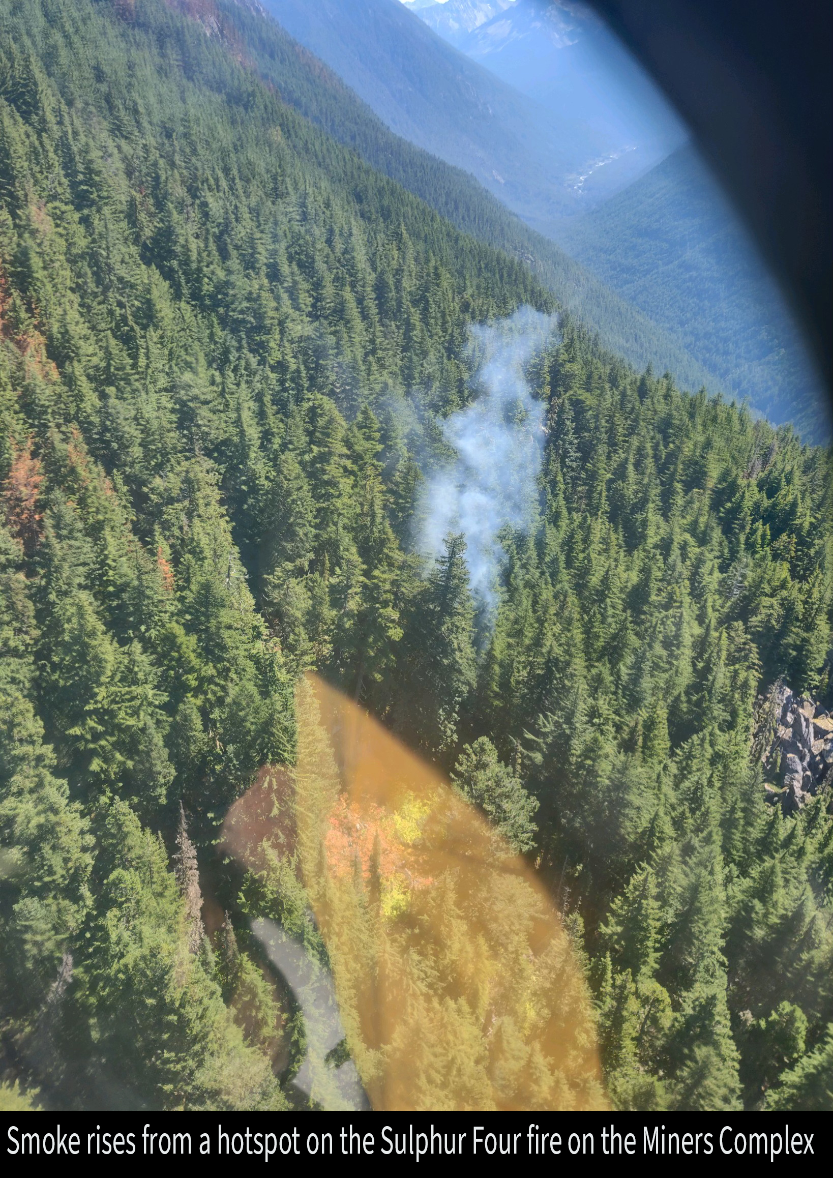
The Miners Complex consists of eight wildfires caused by lightning strikes in the Mt. Baker-Snoqualmie National Forest. The fires included in the complex are Miners Fire, Vista Ridge Fire, Dolly Creek Fire, Sulphur Three Fire, Sulphur Four Fire, Sulphur Thirty-Four Fire, Plummer, and Middle Ridge Fire.
Update: Firefighter crews continue patrols of the Miners Complex along with accompanying rehab work. The helicopter flew a fire crew into Canyon Creek, where they were able to secure a portion of the Sulphur Three Fire that is closest to the Suiattle River Trail which continues the point protect strategy for the Canyon Creek suspension bridge.
Weather: Low level offshore flow into Sunday will result in critical RH values in the afternoon and evening hours this weekend. Low level flow turning onshore late Sunday. Around daytime temperature around 88°F with east winds 6 to 8 mph in the morning becoming light, then becoming northwest 6 to 7 mph late in the afternoon.
Smoke: For more information on smoke and air quality please visit: https://wasmoke.blogspot.com/
Closures: The following is a summary of the areas closed due to the fires in the Miners Complex: Pacific Crest National Scenic Trail #2000.2 from Mica Lake to Suiattle Pass, Suiattle River Trail #784, Miners Ridge Trail #785, Buck Creek Pass Trail #789, Miners Cabin Trail #795, Grassy Point Trail #788, Sulphur Mountain Trail #794, Sulphur Creek Trail #793, Sulphur Creek Campground, Sulphur Creek Trailhead, and the Downey Creek trailhead. Suiattle River Road, closure beginning at Downey Creek trailhead. The full Closure Orders visit: https://www.fs.usda.gov/mbs Forest Restrictions: The Mt. Baker-Snoqualmie has lifted the full campfire ban and forest-wide shooting restrictions, effective 8/28/2024. Additional details at: www.fs.usda.gov/mbs
###
Educational Sparks Ignite at Garden Valley School 08 31 2024
Related Incident:
Publication Type: News
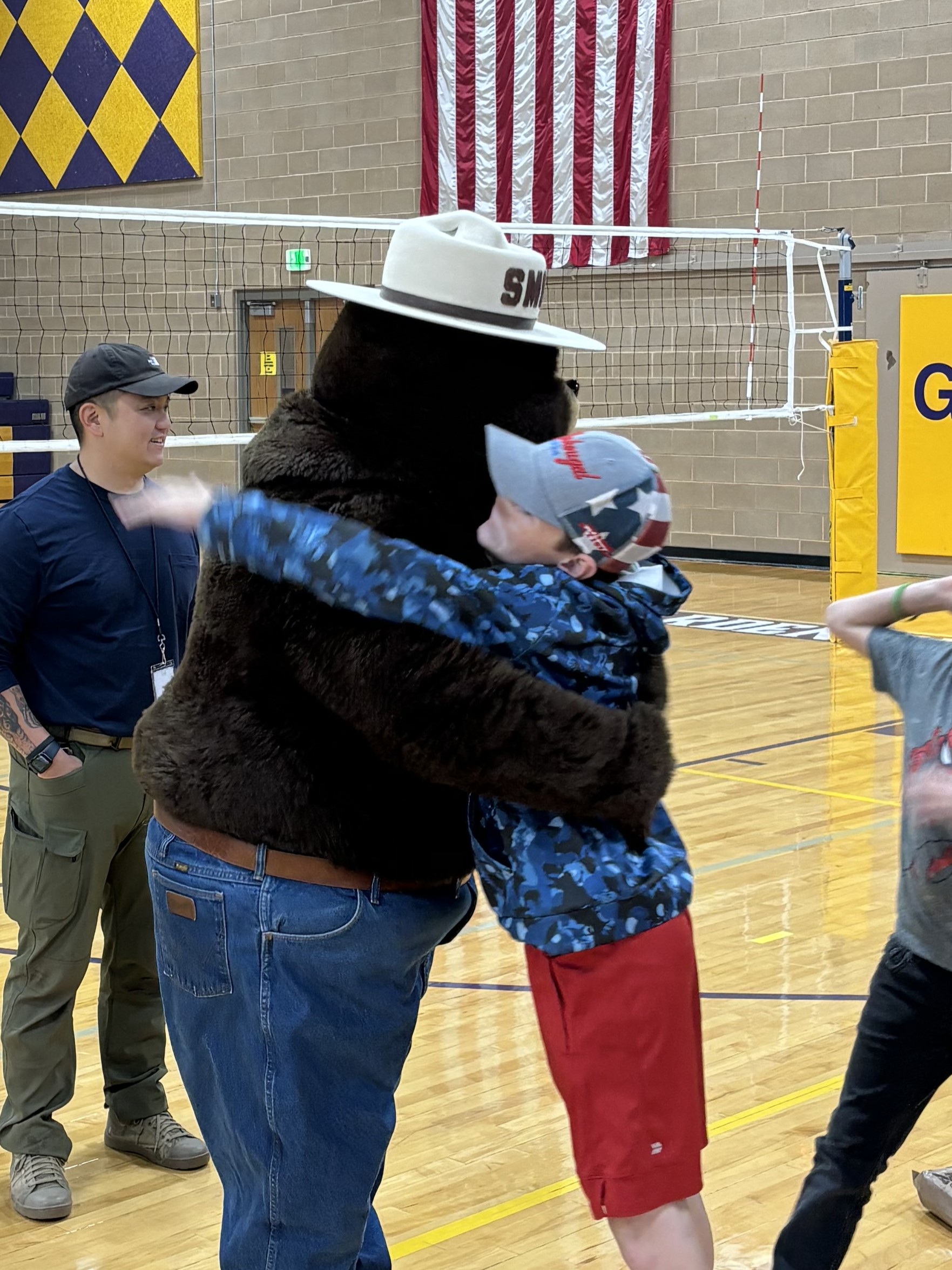
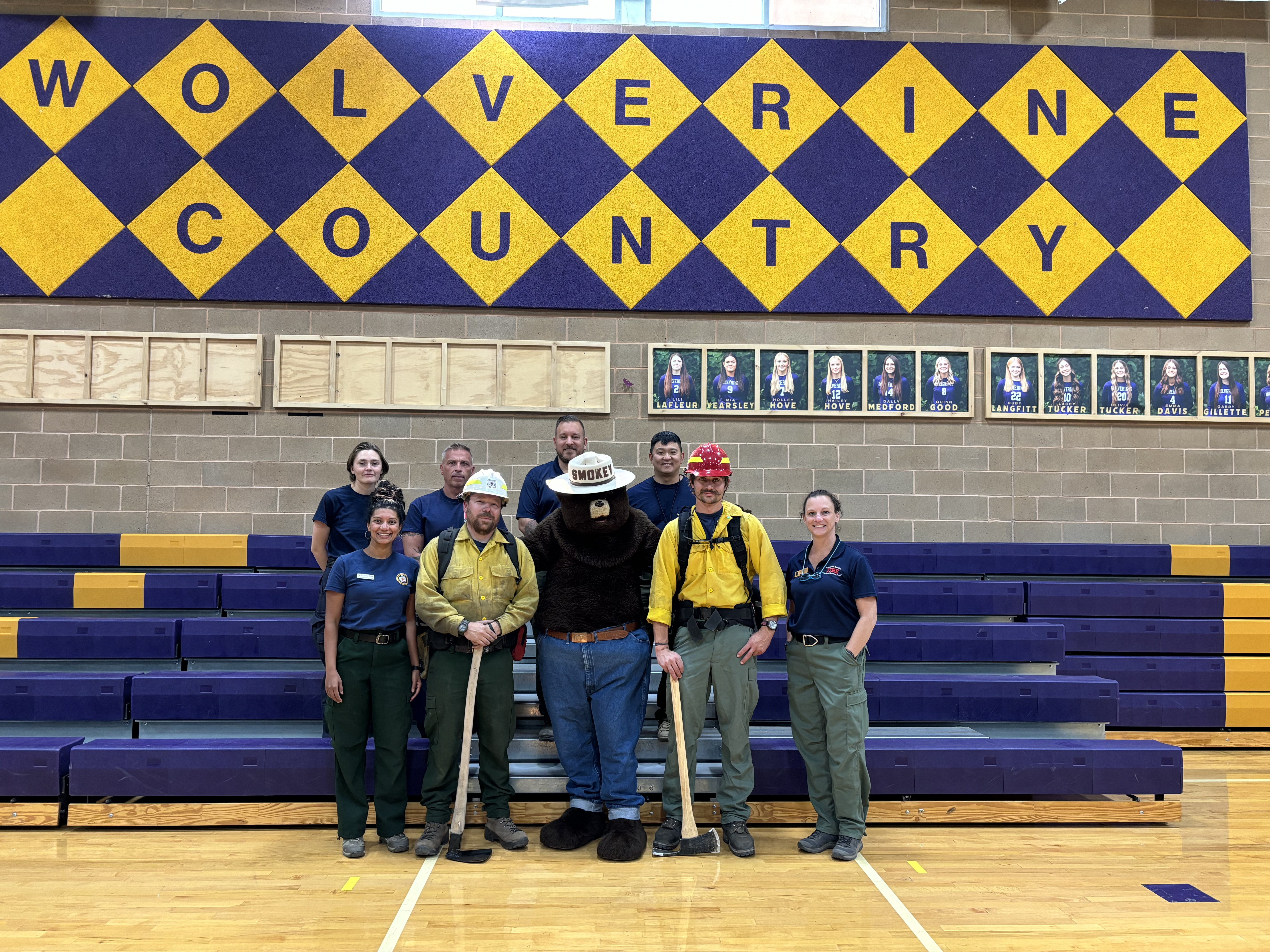
On Thursday, August 29, the Middle Fork Complex Fire’s Public Information Officers had an exciting opportunity to visit Garden Valley School in Garden Valley, Idaho, and chat with students from Kindergarten through Grade 12. The day was split into two energetic assemblies—one for the Kindergarten through Grade 5 group (elementary) and one for the Grade 6 through Grade 12 group (middle and high school).
For the younger students, the fire triangle—heat, oxygen, and fuel—was the star of the show. The officers demonstrated how these elements work together to create a fire and what happens when you take one element away. The real highlight, though, was when Smokey Bear made a surprise appearance, escorted by Fire Chief Paul Cleaveland. The kids were thrilled! As they left, a 5th-grade class passed on heartfelt letters thanking the firefighters. These letters are heading to camp and other places to spread the gratitude!
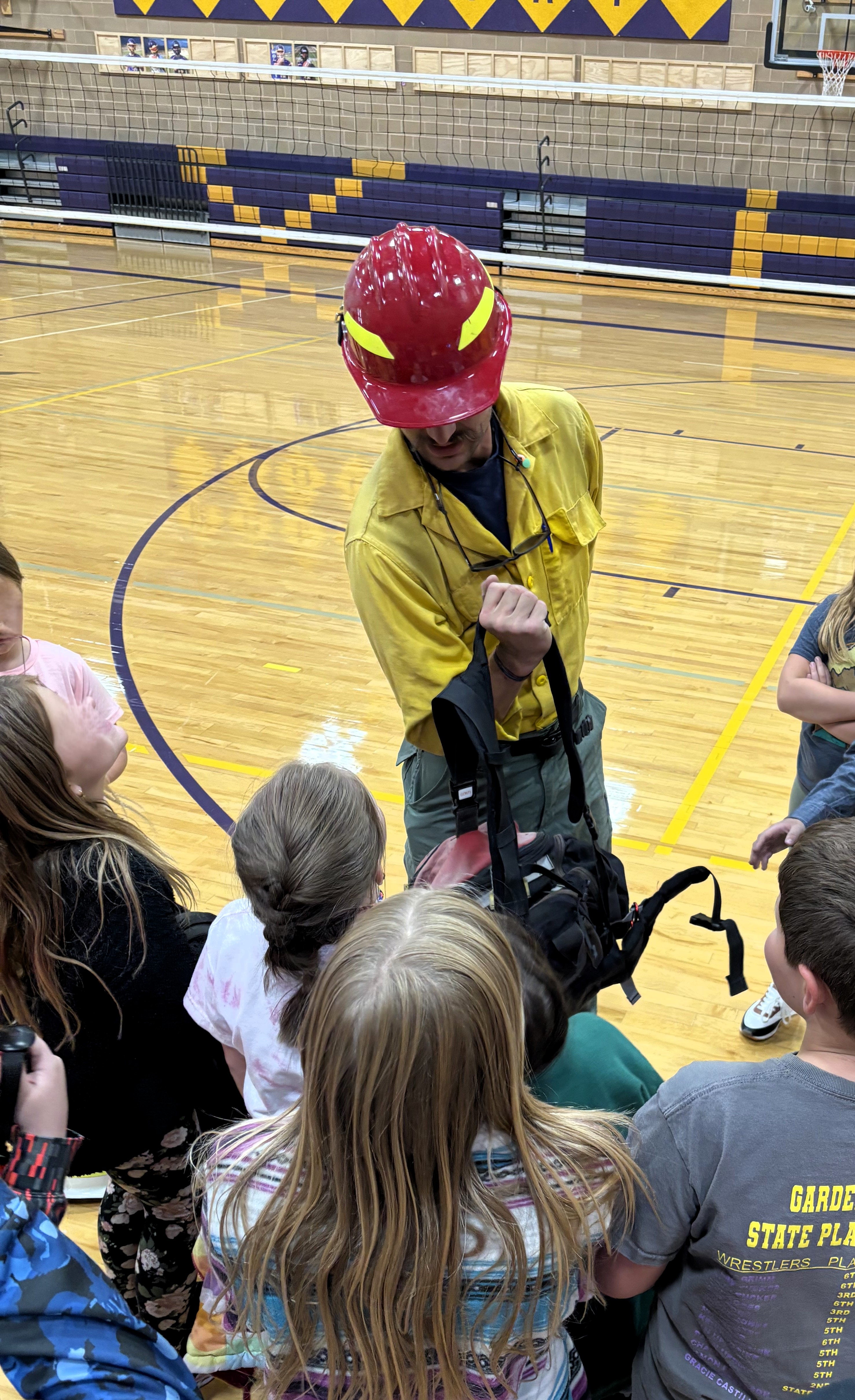
The middle and high school students had their turn to dive into the world of wildland firefighting. Sheena Waters shared her journey from firefighter to Branch Operations Director on the Middle Fork Complex, while Scott Brandt talked about his role as a Fisheries Biologist protecting everything from cultural and historic sites to rare plants and animals during wildfires. The students were engaged and eager to learn, wrapping up with a lively Q&A session that kept everyone on their toes.
A big shoutout to Garden Valley School for hosting such a fantastic day and to Stephanie Patota (Emmett District Visitor Information Assistant) and Andrew Hostad (Boise National Forest Fire Prevention) for their help in making the assemblies a blast!
Check out some pictures from the event:
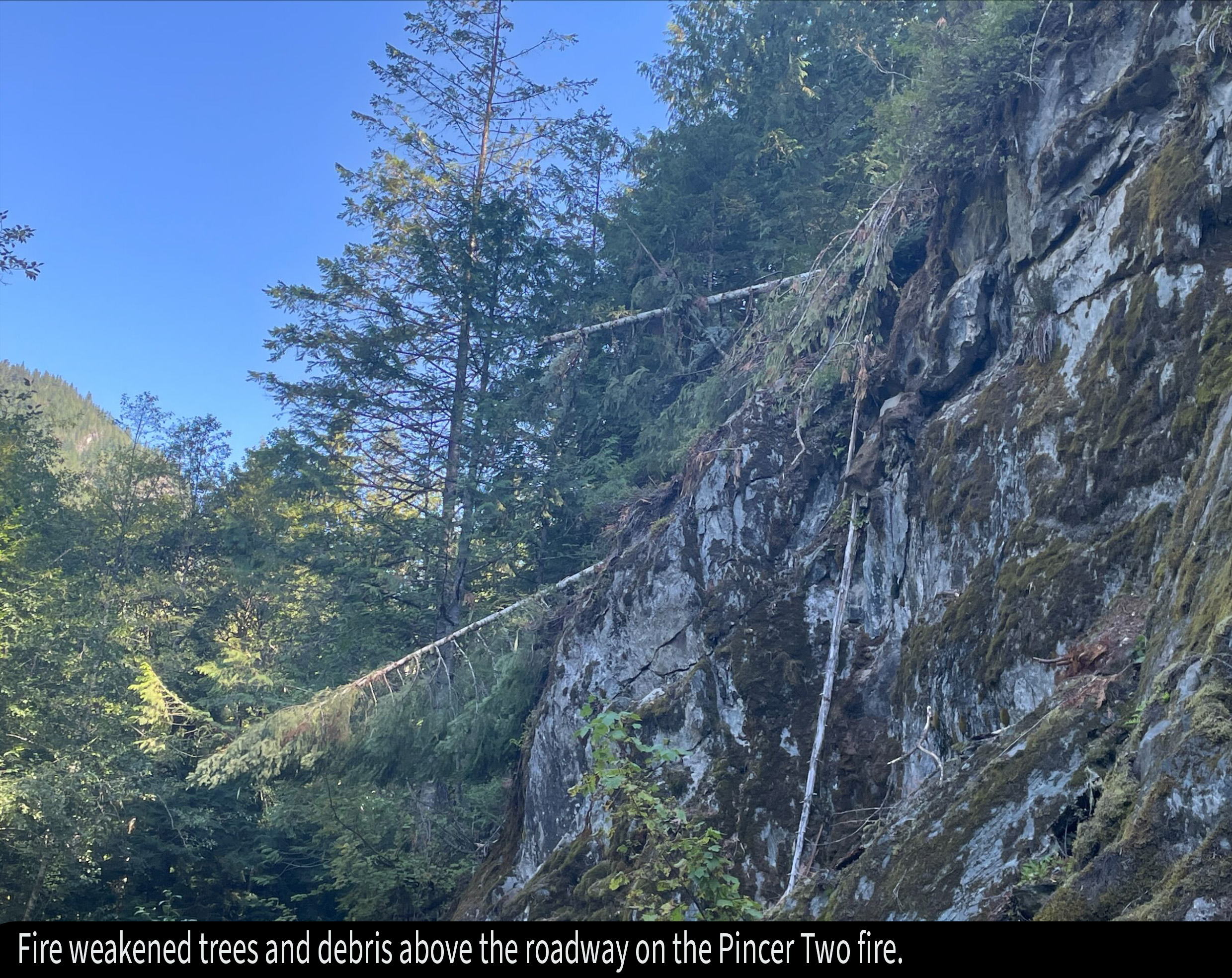
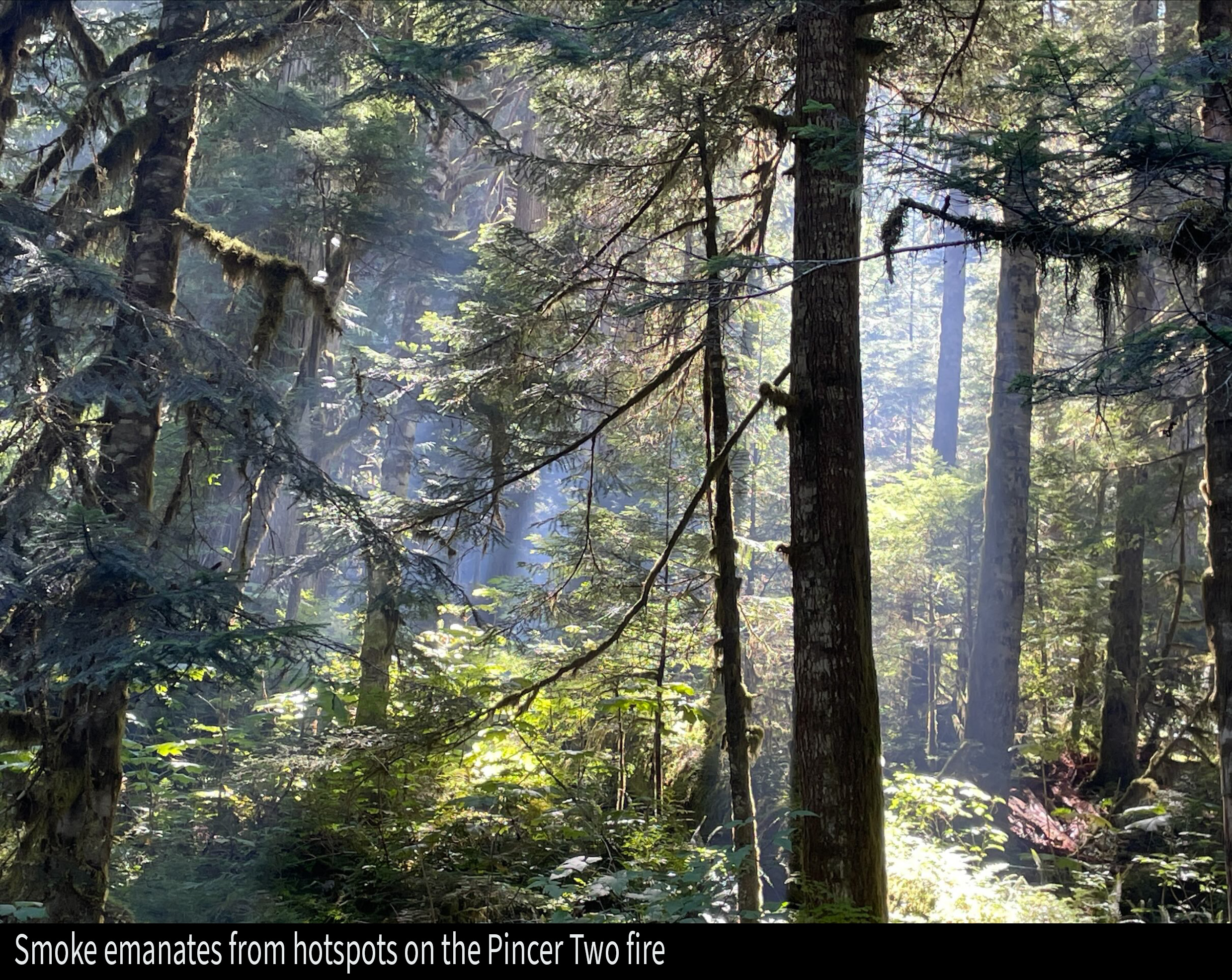
Pincer Two Fire Daily Update 08 31 2024
Related Incident: Pincer Two Fire
Publication Type: Announcement
11:00 AM, August 31, 2024
Estimated size: 211 acres
Start Date/Time: July 17, 2024
Area of Origin: Johannesburg Mountain. 1 Mile East of Mineral Park C.G.
Cause: Lightning
Fuels/Topography: Timber, rugged terrain
Structures Damaged: None, there are no homes threatened at this time.
Evacuations: None
Closures: Cascade River Road at and including Marble Creek Campground, Mineral Park Campground, and all tributary roads, trailheads, and trails are all closed. The public is not to enter the area for public and firefighter safety.
Full closure orders available at: https://www.fs.usda.gov/mbs
Update: Firefighter crews continue patrols of the Pincer Two along the Cascade River Road and Forest Road 1590, with accompanying rehab work. Recon flights will continue through the holiday weekend along with engine crew patrols as the warming weather trend continues.
Weather: Low level offshore flow into Sunday will result in critical RH values in the afternoon and evening hours this weekend. Low level flow turning onshore late Sunday. Around daytime temperature around 88°F with east winds 6 to 8 mph in the morning becoming light, then becoming northwest 6 to 7 mph late in the afternoon.
Smoke: For more information on smoke and air quality please visit: https://wasmoke.blogspot.com/
Air Space Restrictions: There are no air space restrictions at this time.
Forest Restrictions: The Mt. Baker-Snoqualmie has lifted the full campfire ban and forest-wide shooting restrictions, effective 8/28/2024. Additional details at: www.fs.usda.gov/mbs
###
Willamette Complex South Daily Update for Saturday 08 31 2024
Related Incident: Willamette Complex Fires - South
Publication Type: News
Willamette Complex South Update
Chalk, Coffeepot, McKinley, Moss Mountain, Tire Mountain, 208, and 217 Fires
Online: https://inciweb.wildfire.gov/incident-information/orwif-willamette-complex-fires-south
Facebook: https://www.facebook.com/WillametteComplexFires/
Email: 2024.willamettecomplex@firenet.gov
Fire Information Line: 541-208-1742
Saturday, August 31, 2024
Total Willamette Complex South Personnel: 622
Total Willamette Complex South Acres: 13,169
Resources (Includes Pyramid Fire Resources): 1 Type 1 Hotshot crew, 7 Type 2 crews, 3 Type 2 initial attack crews, 4 helicopters, 17 engines, 5 dozers, 150 heavy equipment (masticators, skid steers, feller bunchers, etc.)
Fire Cause: Lightning
Summary
With warmer, drier weather, some smoke was seen on Friday as smoldering heavy fuels flared up in interior areas of the fires. Helicopters made numerous water drops, assisting firefighters on the ground to check the spread of latent heat sources. The total incident acreage increased slightly as the fire crept through previously unburned interior pockets. Still, there was no additional outward spread on any of the fires in the complex. The focus remains on improving indirect firelines and contingency lines and preventing residual hot spots from spreading.
Chalk Fire (5,774 acres, 66% containment)
Patrolling continues on completed containment lines on the fire's north, east, and south sides. Crews are progressing with grading and brushing the Forest Service Road 1824 west of the fire and on other surrounding roads, improving their value as contingency lines.
Moss Mountain Fire (874 acres, 0% containment)
Firefighters worked on the east and north sides of the fire Friday, getting water on hot spots using a hose lay, supplemented by helicopter bucket drops. Today’s focus will be on reinforcing indirect lines, especially along the fire’s west edge where several hot spots remain, and uphill fire runs and torching remain possible.
208 Fire (255 acres, 0% containment)
Monitoring continues using aircraft. Ground crews keep working to improve contingency lines surrounding the fire. Helicopter water drops will be used when feasible on emerging hot spots.
217 Fire (38 acres, 100% contained), Tire Mountain Fire (23 acres, 100% contained), McKinley Creek Fire (24 acres, 100% contained), Coffeepot Fire (6,181 acres, 100% contained)
These fires remain in monitor/patrol status. Mop-up continues on the Coffeepot Fire, as scattered hot spots remain. Helicopters may drop water on hot spots as necessary to keep these fires reined in.
Weather and Fire Behavior
Humidities have remained low and temperatures high the past two nights, accelerating drying of heavy fuels after the recent rains. Relative humidities stayed in the teens most of Friday. Today will bring one more day of hot, dry weather before a weak storm system sends cooler, more humid conditions Sunday through Tuesday. Chances for precipitation from that system are low. Warmer, drier weather returns on Wednesday and Thursday.
Closures and Fire Restrictions
- For specific closure information, visit tinyurl.com/WillFireClosures2024
- For current fire restrictions, visit tinyurl.com/WillFireRestrictions2024
- Temporary Flight Restrictions (TFR): tfr.faa.gov for up-to-date areas. Wildfires are a no-fly zone for unauthorized aircraft, including drones. For more information, visit knowbeforeyoufly.org.
Johnson Fire Area Closure 09 05 2024
Related Incident:
Publication Type: Closures
U.S. Department of Agriculture, U.S. Forest Service
Bitterroot National Forest
Darby-Sula Ranger District
JOHNSON FIRE AREA CLOSURE
PROHIBITIONS
Pursuant to 16 U.S.C. § 551 and 36 C.F.R. § 261.50 (a) and (b), the following is prohibited on National Forest System (NFS) land area, including roads, trails & developed recreation sites on the Darby-Sula Ranger District, Bitterroot National Forest, described below and shown on the attached map incorporated into this Order as “Exhibit A”.
1. Going into or being upon the area described in the Order. 36 CFR § 261.52(e).
2. Public health or safety 36 CFR § 261.53(e).
3. Being on the road. 36 C.F.R. § 261.54(e).
4. Being on the trail. 36 C.F.R. § 261.55(a).
5. Entering or using a developed recreation site. 36 C.F.R. § 261.58(b).
EXEMPTIONS
Pursuant to 36 C.F.R. § 261.50(e), the following persons are exempt from this Order:
1. Any Federal, State, or Local Officer, or member of an organized rescue or firefighting resource in the performance of an official duty.
2. Persons with a Forest Service special use authorization or other authorization specifically exempting them from the effect of this Order.
AREA DESCRIPTION INCLUDING ROADS, TRAILS & DEVELOPED SITES
The closure area starts at the intersection of the East Fork Road and Forest Road 723 continuing Forest Road 723 to the intersection of the western side of Section 7 T2N R 17W. Continuing north along the west side of Section 6 T2N R 17W and Sections 31, 30, 19, 18 & 7 to the Continental Divide. Then following the Continental Divide trending east and then south to the intersection with Forest Trail 40 at Section 27 T3N R16W. Continuing south on the Continental Divide to an area where it changes direction at Section 32 T3N R16W and then continuing south into the Clifford drainage to Forest Trail 169 south to the East Fork of the Bitterroot River at the Junction of Forest Trail 433 at Section 19 T2N R16W. It continues following Forest Trail 433 to Forest Trail 198 at Section 19 T2N R16W. Following Forest Trail 198 south to the Continental Divide, then east on the Continental Divide to the intersection of Forest Trail 462 in Section 20 T1N R17W, then continuing along Forest Trail 462 to the junction with Forest Trail 171 at Section 18 T1N R17W. Then, it continues Forest Trail 171 west to Forest Trail 172 Trail at Section 13 of T1N R18W. Following Forest Trail 172 north to Forest Road 5761 at Section 14 T1N R18W. The closure then continues along Forest Road 5761, transitioning north to Forest Road 725 in Section 10 T1N R18W. On Forest Road 725 it continues north as the western boundary of the closure area back to the East Fork Road where it crosses the East Fork Road Section 24 T2N R18W following it west to the intersection of the East Fork Road and Forest Road 723.
Developed sites closed by this order are Martin Creek Campground and the East Fork Guard Station.
Access to Private Property including the Springer, Bonanza, Little East Fork and other areas are not affected by this closure.
PURPOSE
The purpose of this Order is to ensure public health and safety during fire suppression efforts of the Johnson Fire.
IMPLEMENTATION
This Order shall be in effect from September 5, 2024, at 6am until rescinded or until October 31, 2024, at 6am, whichever occurs first.
A map identifying the Described Roads and Trails is attached and made part of this Order as Exhibit A. For a digital version of this Order and Exhibit A, go to https://www.fs.usda.gov/alerts/bitterroot/alerts-notices.
Unless otherwise expressly defined in this Order, the terms used in this Order are defined by the regulations of the Secretary of Agriculture, 36 C.F.R. Chapter II, Parts 200-299. If there are terms in this Order that are not expressly defined in the Order or 36 C.F.R. Chapter II, Parts 200-299, their meaning shall be determined by their plain language definitions.
A violation of the above prohibitions is punishable as a Class B misdemeanor by a fine of not more than $5,000 for individuals and $10,000 for organizations, or by imprisonment for not more than six months, or both. 16 U.S.C. § 551; 18 U.S.C. §§ 3559, 3571, and 3581.
Contact the Darby-Sula Ranger District in Darby, MT, (406) 821-3913, or Bitterroot National Forest Supervisor’s Office in Hamilton, MT, (406) 363-7100, for more information about this Order.
This Order supersedes any previous Orders prohibiting the same or similar acts in/on the same Described Area/Roads/Trails.
Done at Hamilton, Montana this 5th day of September 2024.
Coffee Pot Fire Update 08 31 2024
Related Incident: Coffee Pot Fire
Publication Type: News
Unified Command: CIIMT5 & CAL FIRE
Fire Size: 7,526 acres
Percent Contained: 11%
Personnel: 1,459
Cause: Lightning
Start Date: Saturday, August 3, 2024, at 10:05 AM
Location: Southeast of Three Rivers, CA
FIRE INFORMATION: Fire information will not be posted on Sequoia and Kings Canyon National Parks Facebook or Instagram pages from Saturday through Monday. Fire information will be available on inciweb.wildfire.gov/incident-information/caknp-coffee-pot-fire and videos will continue to be posted on the Park’s YouTube channel at @sequoiaandkingscanyonnps5018. A Public Information Officer will be at the Three Rivers Village Market on Friday and Saturday from 10:30 AM to 4:00 PM to provide fire information and answer questions.
CURRENT SITUATION: The Coffee Pot Fire is 11% contained and approximately 77% percent of primary control lines have been constructed. Crews are continuing to improve and hold direct control lines. Overall acreage increased by 532 acres.
As expected, fire moved through the Bennett Creek drainage basin and reached the perimeter of primary control lines along the Bennett Creek ridge to the west and along the South Fork Kaweah River to the south. The direct control line along the South Fork Kaweah River is holding, and water-dropping helicopters worked to directly control fire that moved just over Scratch Creek on the southeast flank. A spot fire near Case Mountain was identified and contained with hoses and dozer lines. Fire crews used drones for a strategic firing operation in Nutmeg Grove. This was a defensive operation to protect the grove from a potential high-intensity upfill run of fire. On the northern flank, water-drops from aircraft were used to slow the rate of fire spread as it backed down toward the East Fork Kaweah River. Overnight, crews continued strategic firing operations along the northwest dozer line toward Case Mountain Road. Widening of the indirect control line along Mineral King Road is nearly complete. To the east, the Fire Use Modules continued constructing indirect control lines north toward Horse Creek and Mineral King Road. Crews continued monitoring fire activity in the Eden Creek Grove of giant sequoias.
Today, as weather becomes hotter and drier, crews are working to hold the gains made over the last two days. Firefighters are prioritizing the northern flank, working to slow fire progression with water-drops as it backs down toward the East Fork Kaweah River. Crews are holding the spot fire near Case Mountain with hose lines and by improving constructed dozer lines encircling the fire. On the western and southern flanks, firefighters are holding containment lines west of Bennett Creek and along the South Fork Kaweah River. Hand crews will continue working directly to contain the fire that spread just over Scratch Creek. On the eastern flank, Fire Use Modules continue working to construct indirect control lines to join Horse Creek and Mineral King Road.
EVACUATION NOTICES: A NEW Evacuation ORDER has been issued for zone TLC-E094-B, and a NEW Evacuation WARNING has been issued for zone TLC-E094-D. An Evacuation ORDER remains in effect for zone TLC-E128-B, and an Evacuation WARNING remains in effect for zones TLC-E128-A, TLC-E127-B, and TLC-E094-B. For a current list of evacuations and to find your zone, go to: http://protect.genasys.com/
WEATHER: Warm and dry weather continues over the area with sunny, hazy, and smoky skies. Temperatures will change little. Winds will be diurnal and terrain-driven today and into tonight. Winds will be out the northeast and downslope in the early morning, out of the southwest by mid-morning, and gusting over ridges in the afternoon. Sheltered areas will see upslope winds predominate. The inversion will break in the afternoon. The weather on Sunday will continue to be warm and dry, with low humidity.
SMOKE IMPACTS: Expect smoke impacts similar to the past few days. The area from Three Rivers to Ash Mountain will see the heaviest concentrations in the morning, with levels reaching VERY UNHEALTHY to HAZARDOUS before the smoke begins to lift in the early afternoon. The East Fork Kaweah River toward Mineral King Road will likely see HAZARDOUS levels late afternoon and early evening. The Giant Forest Village can expect smoke to move in later in the afternoon, increasing to UNHEALTHY by tonight. Springville should see improved conditions, with levels averaging MODERATE for the day. Smoke produced during the day will be transported aloft over the valley as far north as Stockton, but will be dispersed at upper levels and have minimal impacts at the surface. For more information on current wildfire smoke impacts in your community, please visit AirNow.gov or fire.airnow.gov.
BLM AND PARK CLOSURES: The portion of South Fork Drive within Sequoia and Kings Canyon National Parks and trails accessed from the road, including the Ladybug and Garfield Grove Trails, are closed. Park closure information is available online at nps.gov/seki. The Bureau of Land Management has also issued a closure of the Case Mountain Extensive Recreation Management Area at blm.gov/press-release.
MINERAL KING FIRE IMPACTS: Recreational access to the Mineral King area of Sequoia National Park is closed to the public. This applies to Mineral King campgrounds, trailheads, and area trails. All other areas of the parks will remain open through the holiday weekend but are likely to be impacted by varying levels of smoke and poor air quality.
PUBLIC NOTICE: Wildfires are a no-fly zone for unauthorized aircraft, including drones. If you fly, we can’t. For more information, visit knowbeforeyoufly.org.
Whisky Creek and Sandstone Fires Daily Update 08 31 2024
Related Incident: Whisky Creek FireSandstone Fire
Publication Type: News
Northwest Team 12
Whisky Creek, Sandstone and Blister Fires
August 31, 2024
Whisky Creek Size: 2,085 acres | Start Date: July 20 | Cause: Human | Containment: 24%
Sandstone Size: 702 acres | Start Date: August 5 | Cause: Lightning | Containment 75%
Total Resources: 536 | Hand Crews: 7 | Engines: 7 | Dozers: 1 | Heavy Equipment: 11 | Helicopters: 4
Fire suppression continues on the Whisky Creek Fire, six miles southeast of Cascade Locks, OR and the Sandstone and Blister Creek Fires, nine miles southwest of Ripplebrook, OR. The fires are burning in steep and rugged terrain on the Mt. Hood National Forest where rolling debris and fire-weakened trees challenge firefighting efforts. Firefighter and public safety remain the incident’s top priority. This Labor Day weekend please help prevent wildfires and protect firefighters by recreating responsibly, respecting fire closures, and complying with all fire restrictions. Firefighters, fire engines, and other resources have been identified on both the Whisky Creek and Sandstone Fires if needed to assist local land management agencies with new initial attack fires in the area.
Whisky Creek: Some smoke continues in the East Fork of Herman Creek due to smoldering fuels. A ground-based assessment uncovered no significant fire activity along the north and northeast flanks. This lessened fire activity enables local resource advisors to evaluate field conditions and identify the complex repairs needed after fire suppression concludes. There was light repair on Forest Service Road (FSR) 2810 while planning is underway to finish the remaining repair work. Patrolling along the eastern containment line up to Green Point Mountain continues, supplemented by an aerial reconnaissance flight yesterday. Repairs will continue along the 409 Trail while non-mechanical repairs are underway along FSR 2080 near the wilderness boundary.
Sandstone and Blister Creek: With no observed fire activity, no bucket drops were needed yesterday on the Blister Creek Fire. Grading and chipping work continues along FSR 7010-630, with mastication on FSR 7015 and chipping along FSR 4620 now complete. An Unmanned Aerial System (UAS) with infrared mapping capability is arriving tomorrow to map remaining heat in inaccessible and difficult to reach areas, to reduce risks to firefighters due to the very steep cliff sides of the Blister Creek Fire.
Weather and Smoke: Today will bring some of the highest temperatures of the incident, with highs in the upper 80s along the ridges to low 90s in the valleys. Lower relative humidity, weak overnight recovery and daytime wind shifts will increase likelihood of scattered smoldering and smoke across the fire areas. However, air quality conditions remain good for both fire areas.
Closures: Mt. Hood National Forest, Columbia River Gorge National Scenic Area, and Hood River County closure information can be found at https://linktr.ee/whisky_creek.2024. Please respect area closure orders for your safety as well as the safety of our firefighters.
Safety: The public plays an important role in preventing the next wildfire; please use caution with all potential ignition sources. For prevention tips visit: https://keeporegongreen.org. The TFR remains in effect for both fires: https://bit.ly/3T59VWv. Fire restrictions are in place within the Mt. Hood National Forest. More information can be found at: https://www.fs.usda.gov/main/mthood/fire.
Actualizacin sobre el incendio Park Viernes 31 de agosto de 2024 08 31 2024
Related Incident: Park Fire
Publication Type: News
Actualización sobre el incendio Park: Sábado, 31 de agosto de 2024
Equipo Administrativo de incidentes complejos del área suroeste
EQUIPO 2 - Comandante del incidente John Truett
Tamaño: 429,603 acres
Fecha de Inicio: 24 de Julio de 2024
Contencion: 95%
Personal Total: 1,521
Recursos: 1 helicóptero, 38 camiones, 52 topadoras, 94 camiones de agua, 17 masticadoras, 82 excavadoras, 10 minicargadoras
SITUACIÓN ACTUAL: Todos los bomberos y recursos de equipos que trabajan en tierras del Bosque Nacional Lassen afectadas por el incendio han sido asignados a uno de tres grupos basados en proyectos: caminos, árboles peligrosos y reparación de extinción de incendios. Estos grupos no se limitan a trabajar en un área geográfica específica del incendio como es el caso durante la fase de extinción. Más bien, las cuadrillas se mueven alrededor del área del incendio hacia donde más se necesitan sus habilidades y equipos. Para facilitar el trabajo posterior a la supresión y priorizar las áreas que necesitan reparación, el personal de bomberos llamado asesores de recursos está trabajando en estrecha colaboración con los supervisores de operaciones y los operadores de equipos. Actualmente hay 23 asesores de recursos trabajando en el incidente. Los asesores de recursos están familiarizados con los recursos naturales y culturales exclusivos del Bosque Nacional Lassen. Garantizan que las reparaciones de supresión sean efectivas y completas. Por ejemplo, muchas líneas de contención que ayudaron a detener la propagación del incendio se construyeron con topadoras. Los asesores de recursos y los operadores de equipos pesados ahora están devolviendo esas líneas de contención a un estado de apariencia más natural y estabilizando el suelo para evitar la erosión y la sedimentación en las vías fluviales. Las áreas ribereñas en las que el personal de bomberos y los asesores de recursos están trabajando para reparar y proteger incluyen Mill Creek, Childs Meadow y Deer Creek.
COMPORTAMIENTO DEL CLIMA Y DEL INCENDIO: Las condiciones inusualmente cálidas y secas persistirán durante el fin de semana festivo y no se esperan precipitaciones. Toda la vegetación, particularmente los pastos extremadamente abundantes, en las cercanías del incendio está muy seca y receptiva a la quema. Cualquier nuevo incendio podría propagarse rápidamente y ser difícil de contener inicialmente para los bomberos. Por lo tanto, el público debe ser especialmente cauteloso este fin de semana festivo y saber qué restricciones contra incendios están vigentes en las áreas en las que se recrean.
CIERRES Y RESTRICCIONES DE INCENDIO: Los terrenos, caminos y senderos del Bosque Nacional Lassen cerca del incendio están cerrados temporalmente según la Orden Forestal No. 06-24-07. Pedimos que las personas respeten el cierre y no intenten acceder a caminos cerrados, lo que permitirá a los bomberos concentrarse en su trabajo, que ya es peligroso, y no correr más peligro por el tráfico de vehículos.
Fire restrictions are also in effect within the Lassen National Forest under Forest Order No. 06-24-04. Both forest orders and supplemental information can be viewed here: fs.usda.gov/alerts/lassen/alerts-notices. ¡Infórmate antes de ir! Encuentre enlaces a las restricciones de incendios de otras agencias de administración de tierras en el árbol de enlaces de información sobre incendios del parque (URL y código QR a continuación).
Información sobre el incendio Park: (Suroeste CIMT 2): 530-414-9298| 2024.park@firenet.gov
Información sobre el incendio Park (CAL FIRE): 530-529-9233
![]() Árbol de enlaces incendio Park (enlaces a sitios web de información sobre incendios): linktr.ee/park_fire
Árbol de enlaces incendio Park (enlaces a sitios web de información sobre incendios): linktr.ee/park_fire
Park Fire Daily Update 08 31 2024
Related Incident: Park Fire
Publication Type: News
Park Fire Update: Saturday, August 31, 2024
Southwest Complex Incident Management Team 2
Incident Commander John Truett
Size: 429,603 acres
Start Date: July 24, 2024
Containment: 95 percent
Total Personnel: 1,514
Resources: 1 helicopter, 38 engines, 52 dozers, 94 water tenders, 17 masticators, 82 excavators, 13 feller bunchers, 10 skidsteers
CURRENT SITUATION: All firefighters and equipment resources working on fire-impacted Lassen National Forest lands have been assigned to one of three project-based groups: roads, hazard trees, and fire-suppression repair. These groups aren’t limited to working a specific geographical area of the fire as is the case during the suppression phase. Rather, crews are moving around the fire area to wherever their skills and equipment are needed most. To facilitate the post-suppression work and prioritize areas that need repairing, fire personnel called resource advisors are working closely with operations supervisors and equipment operators. There are currently 23 resource advisors working on the incident. Resource advisors are familiar with the natural and cultural resources unique to the Lassen National Forest. They ensure that suppression repairs are effective and complete. For example, many containment lines that helped halt the fire’s spread were constructed with dozers. Resource advisors and heavy-equipment operators are now returning those containment lines to a more natural-looking state and stabilizing the soil to prevent erosion and sedimentation in waterways. Riparian areas that fire personnel and resource advisors are working to repair and protect include Mill Creek, Childs Meadow, and Deer Creek.
WEATHER & FIRE BEHAVIOR: Unseasonably hot, dry conditions will persist through the holiday weekend, and no precipitation is expected. All vegetation—particularly the extremely abundant grasses—in the fire’s vicinity is very dry and receptive to burning. Any new fires could spread quickly and be difficult for firefighters to initially contain. Therefore, the public should be particularly cautious this holiday weekend and know what fire restrictions are in effect for the areas in which they are recreating.
SAFETY—AREA CLOSURES & FIRE RESTRICTIONS: Lassen National Forest lands, roads, and trails near the fire are temporarily closed under Forest Order No. 06-24-07. We ask that people observe the closure and not attempt to access closed roads, allowing firefighters to focus on their already hazardous work and not be further endangered by vehicle traffic.
Fire restrictions are also in effect within the Lassen National Forest under Forest Order No. 06-24-04. Both forest orders and supplemental information can be viewed here: fs.usda.gov/alerts/lassen/alerts-notices. Know before you go! Find links to other land management agencies’ fire restrictions in the Park Fire Information Linktree (URL and QR code below).
Park Fire Information (Southwest CIMT 2): 530-414-9298 | 2024.park@firenet.gov
![]() Park Fire Information (CAL FIRE): 530-529-9233
Park Fire Information (CAL FIRE): 530-529-9233
Park Fire Linktree (fire information website links): linktr.ee/park_fire
Williams Mine Fire Update 08 31 2024
Related Incident: Williams Mine Fire-GPNF
Publication Type: News
Williams Mine Fire Update for Saturday, August 31, 2024
The Williams Mine Fire continues to show pockets of active burning as temperatures rise and fuels dry out. Observations from the ground and by air are finding these areas are on the interior of the fire or on the northern edge in the Mt. Adams Wilderness, not threatening containment lines. The fire is consuming ground fuels and reducing the probability of catastrophic fires in the future.
Yesterday, fire personnel covered Morrison Shelter with protective wrap, along with other structures at Morrison Creek and South Climb trailheads. This is in case the fire moves into that area. Other historic structures including Gotchen Guard Station and Wicky Creek Shelter have already been wrapped. As of 8/30/24, no structures have burned on the Williams Mine Fire.
Seven masticators will be working along the FS Rd 23 today, away from other personnel and equipment. Masticators have an extendable arm with a rotating cutter head which can be used to mulch or chop up standing brush and small trees up to 8 inches in diameter. Chunks of woody debris can be propelled hundreds of feet from the machine, dispersing fuels across the ground. A large safety zone is required around these machines to avoid injury to people or damage to other vehicles.
SAFETY AND CLOSURES:
A few people are entering the closed areas on the Gifford Pinchot National Forest, including on the FS Rd 23 south of the FS Rd 23/FS Rd 90 junction. Some are cutting past roadblocks and guards; others are taking back roads. Entering the closure is extremely dangerous, especially on the FS Rd 23. Multiple pieces of heavy equipment are working on the shaded fuel break along the FS Rd 23. Other machines are working on the south and east parts of the fire. A collision with any of these machines could be fatal. Violators are also subject to fines up to $5,000 and up to six months imprisonment.
The Trout Lake Community Rummage Sale is this weekend, 8/30 to 9/2/24. Expect heavy traffic on the roads and watch for pedestrians.
The Confederated Tribes and Bands of the Yakama Nation, Tract D Recreation Area is currently closed, please see Yakama Tract D Road Closure for more information. FS Rd 23 south of FS Rd 90 is still CLOSED to the public due to fire suppression activity. The revised closure for the Mt. Adams Wilderness and FS Rd 23 closure can be found at Williams Mine Fire: Area and Road Closure. The Pacific Crest Trail (PCT) is closed from the PCT's intersection with FS Rd 23 to Potato Hill. The current area closure spans the entire Mt. Adams Wilderness.