
Incident Publication
Magic Feather AM Update 04 11 2025
Related Incident: Magic Feather Prescribed Burn
Publication Type: Announcement
Fire crews have completed a test fire and verified that conditions are good for prescribed fire ignitions today, Friday, April 11, for the Magic Feather Prescribed burn area. While weather values in the local area continue to meet prescription parameters for the project, resources are aware of and monitoring a critical fire weather outlook that is forecasted this weekend. In anticipation of today's burn and this weather outlook, managers have increased on-scene staffing. Additionally, managers have selected a targeted burn footprint for today that is interior of project control lines and surrounded by previously burned areas. Resources will remain on scene through the duration of the project work, which includes monitoring and patrolling the area after ignitions complete today.
Smoke may be notably visible in the Red Feather Lakes and Northern Front Range communities. Fire managers work closely with experts to minimize the impacts of smoke. Air quality is carefully monitored before and during a prescribed fire and all prescribed burns comply with state air quality regulations to minimize impacts to communities. To learn more about the potential health impacts of smoke visit www.colorado.gov/pacific/cdphe/wood-smoke-and-health.
Additional email notifications will be sent out periodically during ignition periods. To receive updates, make sure to join our email list. Additional information can be found here on InciWeb.
Closure Information Updated 04 10 2025
Related Incident: Magic Feather Prescribed Burn
Publication Type: Closures
Please visit https://www.fs.usda.gov/alerts/arp/alerts-notices for all alerts and closure orders for the Arapaho and Roosevelt National Forests and Pawnee National Grassland.
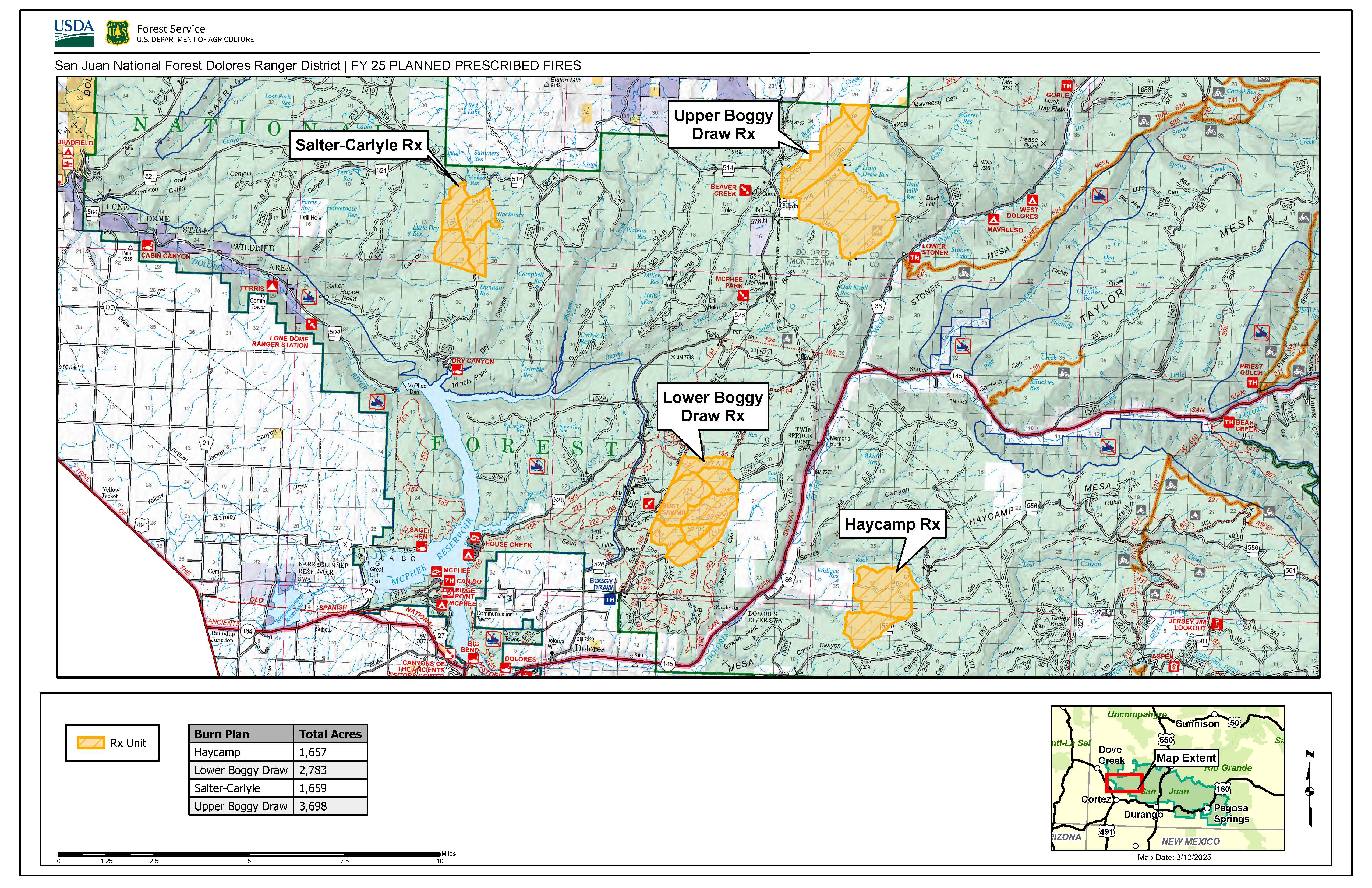
Prescribed burns planned for Dolores Ranger District 04 14 2025
Related Incident: 2025 San Juan National Forest Prescribed Fire Program
Publication Type: News
Dolores, Colo., April 14, 2025 — The San Juan National Forest’s Dolores Ranger District is planning to conduct several prescribed burns starting as early as April 21st. Operations will take place over multiple days when weather and fuel conditions are favorable and may continue throughout the early summer based on conditions. Both hand and aerial ignition methods may be utilized, following the weather, fuel and smoke parameters stated in the prescribed fire plan. Burning operations will be conducted by U.S. Forest Service personnel assisted by fire resources from cooperating agencies.
Project areas identified for burn implementation are:
- Haycamp Mesa: 1,657 acres located 10 miles east of Dolores, along the Haycamp Mesa Road, National Forest Service Road (NFSR) 556 - Haycamp Mesa Units 8, 26
- Boggy Draw: 6,481 acres located 5-15 miles northeast of Dolores, along (NFSR) 527 and (NFSR) 532 - Boggy Draw Units 15, 16, 21, 22, 25A, 25B, 25C, 28, 48, 50, 51
- Salter/Carlyle: 1,659 acres located 15 miles east of Cahone, near Salter Y along (NFSR) 510 - Salter Units 32, 33, 39, 41
This effort will reduce hazardous ground fuels, lessen the risk of unplanned large-scale wildfire, help restore ponderosa pine ecosystems, and improve wildlife habitat. Prescribed fire also reduces the ladder fuels that can carry fire into the canopy, killing mature trees.
During burning operations, smoke may be visible around Mancos, Dolores, Dove Creek, Cortez, and Highway 491 between Dove Creek and Pleasant View. Smoke may settle into low lying valleys and the Dolores River Canyon overnight. Smoke monitoring will be conducted, and ignitions will be scheduled to minimize smoke impacts to communities. Prescribed fire smoke may affect your health. More information can be found online: https://www.colorado.gov/pacific/cdphe/wood-smoke-and-health.
Maps of the prescribed burn units and additional San Juan National Forest prescribed fire program news can be found on InciWeb. For more information, please contact Acting Fire Management Officer Caleb Schutz, by email at Caleb.Schutz@usda.gov or by phone at (970) 882-6844.
For information on the San Juan National Forest, call (970) 247-4874, visit the forest website, or follow us on social media (X and Facebook).
Upcoming Magic Feather Prescribed Burn Window 04 09 2025
Related Incident: Magic Feather Prescribed Burn
Publication Type: News
Fort Collins, Colo. (April 9, 2025) — The Arapaho and Roosevelt National Forest is closely monitoring local conditions to resume prescribed fire operations on the Magic Feather Prescribed Burn, located near Red Feather Lakes, for the end of this week and into next week. The first potential day for ignitions is Friday, April 11, 2025, with favorable forecasts currently extending during various time periods through the end of next week. In the interest of public and firefighter safety, this area will be closed to the public during operations. Watch for warning signs along roads and trails near all prescribed fire areas before, after, and during prescribed burns.
Prescribed fires are used to reduce overgrown vegetation to help protect local communities, infrastructure and natural resources from wildfires. The Magic Feather Project is now in its fifth year of burning, located east and southeast of Red Feather Lakes along Red Feather Lakes Road (County Road 74E). Since April of this year, wildfire managers have successfully treated 500 acres through broadcast burning at Magic Feather.
This project is being executed in a phased manner, with 2,700 acres currently under observation for appropriate conditions. Required prescribed fire conditions include appropriate weather, fuel moistures and smoke dispersal as well as adequate personnel to support the planned project. Weather is monitored throughout the potential burn window and ignitions will not occur if conditions fall outside of the required prescriptions.
Residents and visitors in the vicinity should anticipate the presence of smoke during the prescribed burning operations. Smoke is most likely to be visible from Red Feather Lakes and Northern Front Range communities. Smoke may also impact those using the Dowdy Lake and West Lake recreation areas. Local fire departments and county emergency management officials are collaborating closely on this project, and will be notified when burning begins.
Prescribed fire smoke may affect your health. For more information, visit Wood smoke and your health. Stay informed about scheduled prescribed fires on the Arapaho and Roosevelt National Forests through the forest website, email lists, social media channels and Inciweb
Prescribed Fire Operations Planned April 7 04 06 2025
Related Incident: Lolo National Forest Prescribed Fire Operations
Publication Type: Announcement
Fire officials on the Lolo National Forest may implement prescribed fire operations this week, as weather and fuels conditions allow.
Superior Ranger District: Firefighters will burn up to 0 acres in the Second Chance Creek project area, 8 miles southeast of Superior in the North Fork Second Creek drainage. Smoke may be visible from Interstate 90 in the Lozeau area.
Plains/Thompson Falls Ranger District: Firefighters plan to conduct up to 20 acres of understory burning on the Clear Creek units 6 miles west of Thompson Falls. Minimal smoke impacts are anticipated; however, smoke may be visible from Thompson Falls.
Big Ridge Fire Update April 6 04 06 2025
Related Incident: Big Ridge Fire
Publication Type: News
April 6, 2025
Acres: 3,434 acres Start Date: 03/22/2025
Location: Clayton, GA Personnel: 115
Containment: 88% Fuels: Timber
Resources: 2 crews | 4 engines | 3 dozers | 1 helicopter |1 chipper|1 Excavator
Highlights: This will be the last update for the Big Ridge Fire unless significant activity occurs. Yesterday crews made good progress on fireline repair. The only remaining heat on the fire consists of large logs and stump holes and crews will continue searching for and extinguishing this heat. A closure order is still in place around the Big Ridge Fire for firefighter and public safety. Crews and heavy equipment will still be working and moving around the fire perimeter after this rain passes and the closure will remain in place until it is safe to lift.
The U.S. Forest Service Law Enforcement and Investigations is seeking information regarding the circumstances around the cause of the Big Ridge Fire. If anyone was in the area on March 22, 2025, and observed suspicious activity please call the Georgia Forestry Commission Arson Hotline 1-800-428-7337.
Weather: Heavy rain is expected over the fire area today into Monday. The forecast today calls for 69 degrees, 71% minimum humidity, and winds southwest 8 mph gusting to 28. Thunderstorms are possible. Following this frontal passage temperatures will be much cooler, and humidity will also be lower.
Evacuations: None.
Closures: A closure order is in place for the vicinity of the Big Ridge Fire. For details visit https://inciweb.wildfire.gov/incident-closures/gachf-big-ridge-fire
More Information:
Air Quality: https://www.airnow.gov/
Facebook: https://www.facebook.com/ChattOconeeNF
Email: 2025.BigRidge@firenet.gov
Fire Information: 770-530-3950
Corral Creek Prescribed Fire Operations April 6 04 05 2025
Related Incident: Lolo National Forest Prescribed Fire Operations
Publication Type: Announcement
Ninemile Ranger District: Firefighters will burn up to 40 acres in the Corral Creek project area, 2.5 miles south of Huson. Ignitions are scheduled to begin in the morning hours and will be completed the same day. Minimal smoke impacts are anticipated; however, smoke may be visible from Interstate 90 in the Huson area.
All prescribed fires will be implemented in compliance with Montana air quality standards and coordinated with the Montana Department of Environmental Quality and the appropriate county health departments to minimize the impacts of smoke to neighbors, cooperators, and surrounding communities.
Big Ridge Fire Update April 5 04 05 2025
Related Incident: Big Ridge Fire
Publication Type: News
April 5, 2025
Acres: 3,434 acres Start Date: 03/22/2025
Location: Clayton, GA Personnel: 199
Containment: 88% Fuels: Timber
Resources: 4 crews | 6 engines | 3 dozers | 1 helicopter |1 Chipper| 1 Excavator
Highlights: Today a Type 3 team assumed command of the Big Ridge Fire from the Southern Area Gold Complex Incident Management Team. The primary activity occurring on the fire today is fireline suppression repair. A drone with infrared was used yesterday to identify hot spots that need to be extinguished and will be used again today. The only remaining heat on the fire consists of large logs and stump holes. Crews will continue searching for and extinguishing these remaining sources of heat. No fire spread is expected today.
The U.S. Forest Service Law Enforcement and Investigations is seeking information regarding the circumstances around the cause of the Big Ridge Fire. If anyone was in the area on March 22, 2025, and observed suspicious activity please call the Georgia Forestry Commission Arson Hotline 1-800-428-7337.
Weather: The forecast today calls for 82 degrees, 40% minimum humidity, and winds south-southwest 9-13 mph. There will be occasional gusts to 27. A frontal system is forecast to impact the region Sunday into Sunday night, with widespread showers and scattered thunderstorms expected over the incident area. Chance of wetting rain is 90%. Following this frontal passage temperatures will be much cooler, and humidity will also be lower.
Evacuations: None.
Closures: A closure order is in place for the vicinity of the Big Ridge Fire. For details visit https://inciweb.wildfire.gov/incident-closures/gachf-big-ridge-fire
More Information:
Air Quality: https://www.airnow.gov/
Facebook: https://www.facebook.com/ChattOconeeNF
Email: 2025.BigRidge@firenet.gov
Fire Information: 770-530-3950
Big Ridge Fire Recorded Information Line: 706-982-4729
Forest Closure Order for Rattlesnake Branch Fire 04 04 2025
Related Incident: Rattlesnake Branch
Publication Type: Closures
UNITED STATES DEPARTMENT OF AGRICULTURE
FOREST SERVICE
NATIONAL FORESTS IN NORTH CAROLINA
PISGAH RANGER DISTRICT
PISGAH FOREST, NORTH CAROLINA
FOREST ORDER# 08-11-07-25-01
Pursuant to 16 U.S.C. § 551 and 36 CFR §§ 261.50 (a) and (b), the area of National Forest System lands in the “Rattlesnake Branch Fire Area” located on the Pisgah Ranger District of the Pisgah National Forest is closed to entry. The area is closed to entering and/or being upon or present. This order is intended to mitigate risks to public health and safety, and to provide for disaster and safety operations, and to protect the resources while responding to and recovering from the Rattlesnake Branch fire. This closure is effective until May 31, 2025, or until rescinded by an authorized Forest Service official, whichever occurs first.
The area that is closed includes National Forest System lands within the Shining Rock Wilderness as depicted on the attached map. Only National Forest System lands are impacted by this closure.
The above prohibited acts are set forth in 36 CFR section 261.53 (e) Special Closures for Public Health or Safety. It is prohibited to go into or be upon any of the area described in this order.
Pursuant to 36 CFR, § 261.50 (e), the following persons or areas are exempt from this Order:
- Persons with a special use permit or contract specifically authorizing the otherwise prohibited act of omission.
- Any Federal, State, or local officer, or member of an organized rescue or firefighting force in the performance of an official duty.
Executed in Asheville North Carolina, on April 4, 2025.
____________________________
James E. Melonas
FOREST SUPERVISOR
NATIONAL FORESTS IN NORTH CAROLINA
Violations of the above prohibition are punishable by a fine of not more than $5000.00 for an individual and $10,000 for an organization or imprisonment for not more than six months or both. Title 16 USC 551 and Title 18 USC 3559 and 3571.
Rattlesnake Branch Daily Update 04 04 2025
Related Incident: Rattlesnake Branch
Publication Type: News
Media Contact:
Southern Area Red Team
2025.RattlesnakeBranch@firenet.gov
(828) 519-8242
https://inciweb.wildfire.gov/incident-information/ncncf-rattlesnake-branch
https://www.facebook.com/nfsnc/
Rattlesnake Branch Fire Final Update -- April 4, 2025
NOTE: This is the last update of the Rattlesnake Branch Fire by the Southern
Area Red Complex Incident Management Team. A smaller team will remain in
place for the remainder of the incident and can be reach at the contact above.
CRUSO, N.C., April 4, 2025 – The Rattlesnake Branch Fire remains at
approximately 1,843 acres and 26-percent contained. With several resources
returning home, more than 110 personnel continue to work on the fire.
Yesterday’s Activities
Yesterday, many firefighters and equipment were released from the fire because
they were in excess of current needs for the Rattlesnake Branch Fire. Management
of the fire has shifted to monitoring, patrolling and completing data collection for
structure protection and potential places for fire line construction. In the Crawford
Creek Area, crews cleared roads for emergency access. Most of the assessment
work yesterday was northwest and west of the fire, near the Camp Daniel Boone
Boy Scout Camp and including the Frazier and Little East Fork Road systems. The
drone flew up to the peak of Cold Mountain and checked the southern fire perimeter
for heat signatures. Some areas of the fire received more rain yesterday.
Today’s Activities
More firefighters and equipment will be released from the fire today. Remaining
personnel will continue to patrol and mop up around structures in Crawford Creek
and Cruso, as needed, and improve fire lines to protect structures in the Burnett,
Lenoir and Dix creek drainages and around the Boy Scout Camp.
A hotshot crew will also work to assess and clear trails on Cold Mountain. Roads
and fire lines used for fire suppression around Crawford Creek, Cruso and Burnette
Cove Road will be repaired, including installing water bars on roads to prevent
erosion. Firefighters will continue to collect data on potential future fire lines and
structures for a structure protection plan, including data on interior logging logs west
of the current fire footprint.
Weather/Fire Behavior: Today will be mostly cloudy with warmer temperatures and
strong southerly winds. A strong, rainy cold front arrives Sunday, with wetting rain
(1.5 – 1.75 inches) and thunderstorms. The high temperature today will be 71 -76
degrees with 45-48 percent minimum relative humidity. Winds will be south to
southwest, 10-14 mph with gusts to 32 mph.
Minimal fire activity is expected again today due to moisture retained by dead leaves
and woody vegetation on the ground.
Closures and Restrictions: The Pisgah National Forest has modified an area
closure of the Shining Rock Wilderness Area to protect the public from wildfire and
firefighting operations. This closure includes all National Forest System land in the
Shining Rock Wilderness Area only. Please stay safe and keep out of the wilderness
area.
A temporary flight restriction is in effect in and around the fire area. This includes
use of personal drones.
For wildfire updates, follow the National Forests in North Carolina on Facebook at
www.facebook.com/nfsnc or visit https://inciweb.wildfire.gov/incidentinformation/
ncncf-rattlesnake-branch.