
Incident Publication
Descanso Ranger District Prescribed Burn 02 05 2025
Related Incident: 2025 - Cleveland National Forest, Forest Health Treatments
Publication Type: News
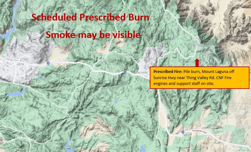
Prescribed Fire: Cleveland National Forest fuel crews are continuing a prescribed burn project off of Sunrise Highway near Thing Valley Road. Residents and visitors may see smoke from Sunrise Highway, the I-8, and surrounding communities. Crews will be burning piles of hazardous fuels (brush) today.
Prescribed Fire Updates 02 05 2025
Related Incident: Mendocino NF Fall 2024/Spring 2025 Prescribed Fire Projects
Publication Type: News
Today at the Chico Seed Orchard firefighters will be burning up to 10 acres of piles, pending favorable conditions. Some smoke may be visible. Please avoid the area and know that prescribed fire activities are carefully monitored.
On the Upper Lake Ranger District, firefighters accomplished 12 acres of pile burning yesterday, and that unit remains in patrol status. For the rest of the week no additional burning is planned on the Upper Lake/Covelo Districts.
Firefighters will be looking at additional prescribed burning opportunities next week after this weekend’s storms.
Maps of pile burn operations can be found on Inciweb under the Maps tab.
Current Pile Burning Activity 02 05 2025
Related Incident: Arapaho and Roosevelt National Forests Pile Burning
Publication Type: Announcement
Larimer County, Canyon Lakes Ranger District – Week of Feb 4 to Feb 11, 2025
Fire managers do not have any new pile burning plans for the coming week.
This past weekend, strong gusty winds in several Canyon Lakes Ranger District locations resulted in an increase in fire behavior for ignited piles, leading to more smoke and flames visible in some active project areas. Due to the change in conditions, fire crews increased their patrolling and monitoring of active pile burn project areas and completed additional mop up and securement work. This work was done at the following locations:
Glen Haven 2 & 3: Hand piles. Adjacent to Glen Haven on both sides of County Rd 43.
Thompson River 4: Hand piles. 6 miles east of Estes Park, along FSR 122 (Pole Hill Rd).
Thompson River 5: Hand piles. 4 miles southeast of Estes Park, at the intersection of Highway 36 and FSR 124.
Red Feather 5: Hand piles. 4 miles northeast of Red Feather Lakes, along County Road 67J (Prairie Divide Road).
Fire personnel will continue to patrol and monitor all recent pile burning locations until work has been completed. For the most up to date status on each unit, please visit our Rx Fire Map.
Blue Hills Fire 242025 800 pm Final Update 02 05 2025
Related Incident:
Publication Type: News
Blue Hills Fire Final Update
Size: 3,900
Containment: 100%
Cause: Under Investigation
Today, 2/4/2025, crews spent the operational shift mopping up any hotspots that were found. Through the evening, no smokes or heats were spotted throughout the fire area. Command deemed safe to say the Blue Hills fire is 100% contained and does not plan to send any more resources to this fire. All resources were released this evening.
Hughes PostFire BAER Soil Burn Severity Map Released 02 04 2025
Related Incident: Hughes Post-Fire BAER
Publication Type: News
Hughes Post-Fire BAER Soil Burn Severity Map Released
February 4, 2025
USDA Forest Service Burned Area Emergency Response (BAER) specialists recently completed their data gathering and analysis for federal lands in the Hughes Fire burned area to produce a post-fire Soil Burn Severity (SBS) map.
The BAER assessment team used initial remote sensing imagery with their field-validated soils data to develop and produce a map showing soil burn severity levels for the burned area. The SBS is broken into four different classes: unburned/very low (green), low (blue), moderate (yellow), and high (red). For more information on these different SBS classifications, see the BAER Information Brief at: https://inciweb.wildfire.gov/incident-publication/caanf-hughes-postfire-baer/baer-information-briefunderstanding-soil-burn-severity-02-03-2025.
The BAER SBS map and data display categories of unburned/very low, low, moderate, and high soil burn severity in different colors for the different categories. Of the 10,429 acres within the Hughes Fire perimeter, 3,233 acres are non-Forest Service land, 7,196 acres are National Forest System (NFS) land, and 114 acres are unevaluated urban land. Of the 10,315 acres analyzed by the Forest Service BAER team, approximately 62% of these acres are either unburned/very low or low soil burn severity, while 37% sustained a moderate soil burn severity, and about less than 1% were identified as having high soil burn severity.
You may see several types of fire severity and intensity maps produced by different incident management staffs. If they look different for the same fire, it is because they measure different metrics to describe the effects of the fire. Forest Service BAER maps are primarily measures of fire effects on soils. See also Fire Intensity vs. Soil Severity Effects BAER Information Brief at: https://inciweb.wildfire.gov/incident-publication/caanf-hughes-postfire-baer/baer-information-brief-fire-severity-and-fire-intensity-effects-02-02-2025.
Heat from fire changes soil chemistry which in turn affects what will happen during storm events after fires. The team hydrologists, soil scientists, and geologists use the final soil burn severity map to model and predict areas likely to experience flooding, erosion, sedimentation, and debris flows. The BAER team, the US Geological Survey (USGS), Natural Resources Conservation Service (NRCS), National Weather Service (NWS), and the California State Watershed Emergency Response Team (WERT) all utilize the soil burn severity map as an analysis tool to estimate post-fire watershed response to precipitation events. In specific areas that are predicted to have high levels of post-fire response, the team and their partner agencies assess the need for and feasibility of various treatments.
The Hughes Fire SBS map can be downloaded at the Hughes Post-Fire BAER InciWeb site: https://inciweb.wildfire.gov/incident-information/caanf-hughes-postfire-baer under the Maps” tab.
BAER SAFETY MESSAGE: Everyone near and downstream from the burned areas should remain alert and stay updated on weather conditions that may result in heavy rains and increased water runoff. Flash flooding may occur quickly during heavy rain events--be prepared to act and note emergency alerts issued by Los Angeles County. Current weather and emergency notifications for the Hughes Fire area can also be found at the National Weather Service website: www.weather.gov/lox/.
###
Descanso Ranger District Prescribed Burn 02 04 2025
Related Incident: 2025 - Cleveland National Forest, Forest Health Treatments
Publication Type: News
Prescribed Fire: Cleveland National Forest fuel crews are burning piles off of Sunrise Highway near Thing Valley Road. Residents and visitors may see smoke from Sunrise Highway, the I-8, and surrounding communities. Crews are planning to burn 12 piles of hazardous fuels (brush) today.
Prescribed Fire Updates 02 04 2025
Related Incident: Mendocino NF Fall 2024/Spring 2025 Prescribed Fire Projects
Publication Type: News
EDIT: Burning today in Colusa County is cancelled due to high winds. Firefighters will attempt tomorrow, pending favorable conditions.
This week on the Grindstone Ranger District, firefighters plan to burn piles in the Letts Lake basin, up to 50 acres pending favorable conditions.
We ask visitors to avoid areas where prescribed operations will be taking place. Some smoke may be visible. People should not be alarmed as the fires are carefully monitored. Local fire and government authorities are notified prior to burn days and kept informed throughout prescribed fire operations.
Maps of pile burn operations can be found on Inciweb under the Maps tab.
Blue Hills Fire 242025 1100 am Update 02 04 2025
Related Incident:
Publication Type: News
Blue Hills Fire
Size: 3,900
Containment: 85%
Cause: Under Investigation
Today, 2/4/2025, crews returned out to the fire this morning and report little to few smokes throughout the fire area. Plan for today is for crews to continue mop up operations over the fire area, especially focusing on the slop from yesterday. Fire engines will be utilized to patrol and extinguish heats found throughout the fire. The area that jumped containment yesterday afternoon was mapped at 32 acres making the total acreage of this fire being 3,900.
Blue Hills Fire 232025 800 pm Update 02 04 2025
Related Incident:
Publication Type: News
Blue Hills Fire
Size: 3,868 Acres
Containment: 85%
Cause: Under Investigation
Today, 2/3/2025, crews continued to mop up and patrol fire perimeter. An area on the south right flank of the fire was holding heat in heavy fuels, such as down cottonwood trees, and reignited in the mid afternoon around 2:30 pm causing a small estimated 30 acre slop (fire that crossed barrier or line that was intended to contain it.) over containment lines. High temperatures and low humidity allowed for fire activity to increase and thus, the slop made a strong run through tall grass and heavy woody fuels. Mutual aid was requested through Borger Fire Department and Potter County Fire and Rescue. Texas A&M Forest Service, National Parks Service, Borger FD and Potter County Fire were able to stop the forward progress of this fire through use of hose lays and UTVs because access to this location was very difficult as it was in the bottom of a dry lakebed. Crews continued mop up operations on this slop until deemed safe to leave for the night. Accurate mapping over the slop will take place tomorrow to get true acreage. Texas A&M Forest Service law enforcement is conducting an investigation into the cause of the Blue Hills Fire. Fire personnel have been released from the fire for the night and will return in the morning.
Prescribed Fire Updates 02 03 2025
Related Incident: Mendocino NF Fall 2024/Spring 2025 Prescribed Fire Projects
Publication Type: News
This week on the Upper Lake Ranger District, firefighters are potentially burning piles along the roadside on the M1 Rd (15 to 45 acres) in the Pine Mountain area.
We ask visitors to avoid areas where prescribed operations will be taking place. Some smoke may be visible. People should not be alarmed as the fires are carefully monitored. Local fire and government authorities are notified prior to burn days and kept informed throughout prescribed fire operations.