
Incident Publication
Pack Trail Fire Daily Update October 16 2024 10 16 2024
Related Incident:
Publication Type: News
Total Acres: 86,555 Confined: 62% Total Personnel: 613
PACK TRAIL FIRE
Wednesday, October 16, 2024 Update
Fire Information Phone: 307-395-2351 | Email: 2024.Packtrail @firenet.gov
Total Acres: 86,555 Confined: 62% Total Personnel: 613
Operations – Yesterday on the east side of the fire, ground crews continued to secure the 540 Road, continuing their mop-up operations along that feature. On the south side, the Pack Trail Fire saw increased fire activity during the evening periods but crews supported by aviation were able to keep the fire north of the Union Pass road. The fire continued to be active in the areas around Cowboy Camp, Strawberry Warming Hut, and Fish Creek Guard Station to various degrees. SSW winds and receptive fuels contributed to activity across the fire area. On the west flank, in the Gros Ventre River Basin, firefighters continue patrolling the Burnt Ridge area and use aircraft to slow the fire’s advance into the valley where appropriate. The structure protection group continued their work around values at risk in the valley.
Safety – Teton Interagency Fire managers are maintaining the Very High Fire Danger Rating for Grand Teton National Park, the Bridger-Teton National Forest, the Shoshone National Forest , and the National Elk Refuge. Please use caution while driving these areas, especially on narrow secondary roads. Always expect to encounter fire vehicles and heavy equipment in and around the fire area. Check with WY-DOT for possible closures due to fire activity, especially if you are planning to travel on US-26 across the Continental Divide. Closures are not expected, but with active fire in the area checking status before travel is recommended.
Due to excessively dry fuels, any spark can ignite fire which can grow rapidly into a major incident. Residents and visitors are urged to exercise extreme caution with fires or other possible ignition sources. Always build campfires away from dry grass, leaves, and overhanging branches to reduce the risk of spreading wildfire. Clear at least a 10-foot perimeter around your fire, removing any flammable material, and have enough water on hand to ensure your fire is dead out and cool to the touch before you go to sleep or leave the area.
Remember that flying a personal drone over a fire area during a temporary flight restriction is illegal and can be an extremely dangerous threat to both our aviators and firefighters on the ground. “If you fly, we can’t.”
Weather – Today’s weather conditions still present the potential for increased fire behavior in the afternoon as winds continue from the SW with potential for gusts at elevation in the 20 MPH range as the expected cold front approaches. The forecast calls for high temps in the 60’s and relative humidity between 18% and 22%. Smoke will be a factor in many areas surrounding the fire. To learn more about air quality, visit Fire.AirNow.Gov.
Evacuations – Brooks Lake Lodge, Pinnacle Cabins, Falls Camp, and Long Creek have been reduced to a Level 2 “Set” Evacuation Warning. Level 3 “Go” evacuation orders remain in effect for Lava Mountain Lodge and McKenzie Highland Ranch. The Dunoir Road Corridor has been reduced to a Level 1 “Ready” Evacuation Warning. See the Fremont County Emergency Management Facebook Page for alerts and updates. See the Teton County Emergency Management website updates and to sign up for emergency alerts through Everbridge.
Road Closures – The Union Pass Road is closed on the Pinedale District (BTNF) from Mosquito Lake to the DuNoir on the Wind River District (SHO).
Forest Closures - Closure Order #04-03-24-317 is in effect from October 14, 2024 at 12:00 p.m. through November 15, 2024 at 12:00 a.m. unless rescinded. This order supersedes previous orders, including #04-03-24-316, prohibiting the same or similar acts in the same described area.
For more information, visit: Facebook: USDA Forest Service - Bridger-Teton National Forest, USDA Forest Service - Shoshone National Forest Pack Trail Inciweb: https://inciweb.wildfire.gov/incident-information/wybtf-pack-trail-fire
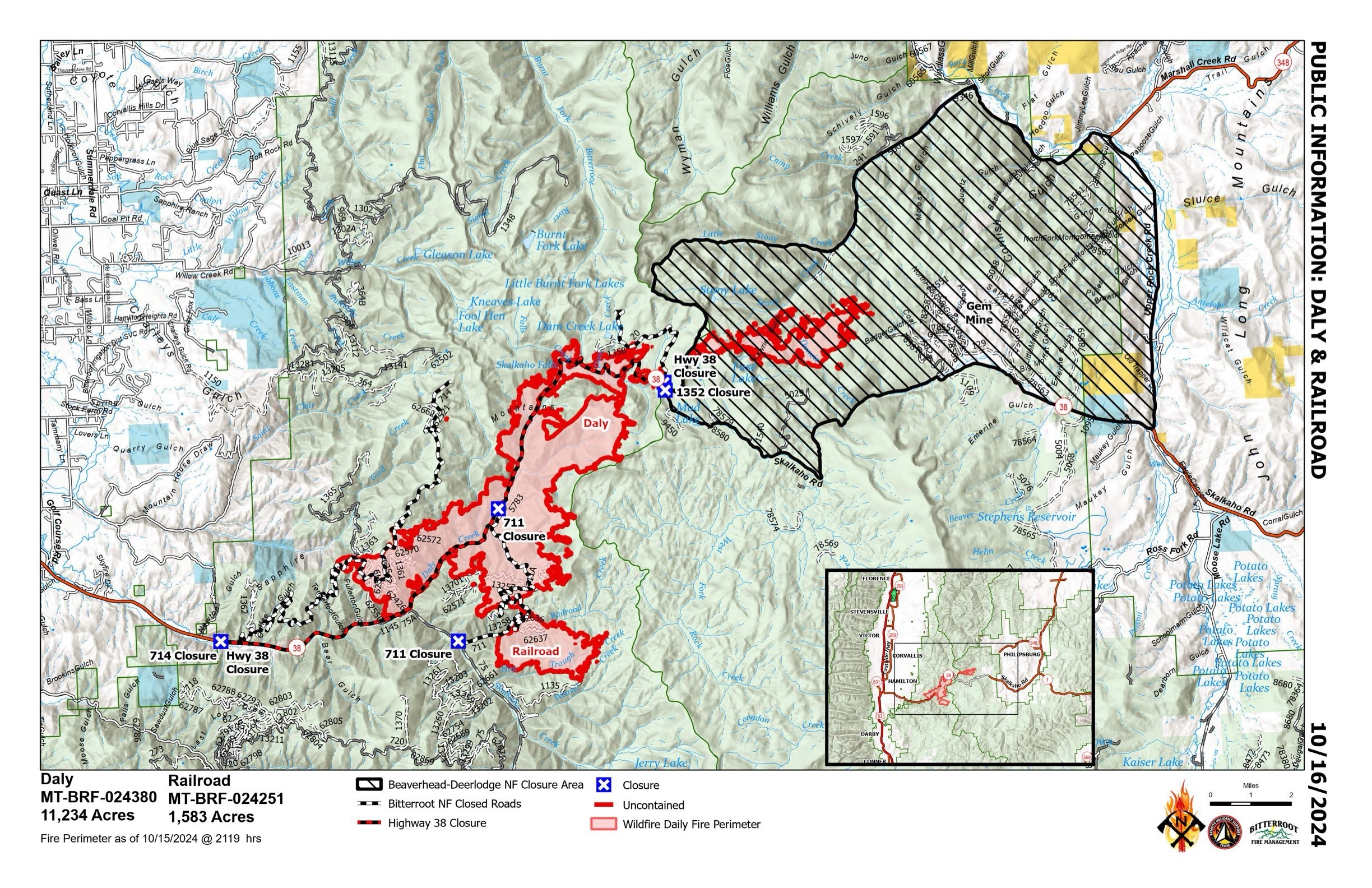
RailroadDaly Fire Update 10 16 2024
Related Incident:
Publication Type: News
Railroad-Daly Fire Update
Type 3 Incident, Incident Commander Justin Abbey, ICT3 Trainee: Chris Kramer
Location: Bitterroot NF: Railroad Creek/ Skalkaho Creek confluence, 26 miles southeast of Hamilton
Beaverhead-Deerlodge NF: 20 Miles northwest of Georgetown Lake Dam off Skalkaho Hwy 38
Start Date: 7/25/2024
Cause: Undetermined
Daly Fire Acres: 11,234 Railroad Fire Acres: 1,583 Completion: 56%
Total Personnel: 265
NOTE: Official Transfer of Command took place today @ 0700 to Justin Abbey & Chris Kramer.
CURRENT STATUS
Yesterday minimal fire behavior was observed with internal heavy fuels burning and isolated tree torching. During the night hours fire backed down closer to Hwy 38. A Fire Engine remained in that area to monitor progression towards values. Multiple helicopters aided firefighters with buckets of water to suppress areas of heat along fire perimeter.
In efforts to prevent hazard trees from falling across Skalkaho Hwy 38, sawyers continued cutting standing dead trees and used a woodchipper to shred limbs into smaller wood chips.
Today, crews will hold and monitor previous firing operations. Sawers will continue clean up above Skalkaho Hwy 38 removing the amount standing dead snags and will continue chipping ground fuels. Crews will continue constructing a shaded fuel break along coal creek road. Crews will also continue constructing a fuel break along Hwy 38 to keep fire north of Hwy 38 and east of FS Rd #75. Construction of dozer, hand line will continue along Gird Creek Ridge. Aerial resources will remain engaged to slow fires spread down canyon towards values.
Fire Crews will remain in place along Hwy 38 monitoring fire activity during the night hours.
WEATHER AND FIRE BEHAVIOR
Today will be the last of the warm and dry days this week. Elevated fire weather concerns are still anticipated for Wednesday afternoon as gusty winds increase, and low relative humidity remains. There is a decent chance of wetting rains on the terrain Wednesday night as a cold front passes through. Cool and wet conditions will continue into Thursday. Thursday night will bring snow to 4,000 feet in the Bitterroot. EVACUATIONS
On October 9, 2024 the Ravalli County Sheriff’s Office issued an Evacuation Warning for residents off of Skalkaho Highway (1700-2500 block) due to the Railroad-Daly Fire. For more information on evacuations visit the Ravalli County Sheriff Facebook page.
To register your phone number for emergency notifications in Ravalli County visit, http://hyper-reach.com/mtravallisignup.html.
CLOSURES
The Beaverhead-Deerlodge National Forest has issued an Area/Road/Trail Closure effective October 4, 2024.
The Bitterroot National Forest has also issued a road closure effective October 10, 2024.
These orders are for public and firefighter safety during fire suppression efforts on the Fire.
Closure information and maps are posted on the Bitterroot and Beaverhead-Deerlodge National Forests’ website www.fs.usda.gov/alerts/bdnf/alerts-notices and www.fs.usda.gov/alerts/bitterroot/alerts-notices.
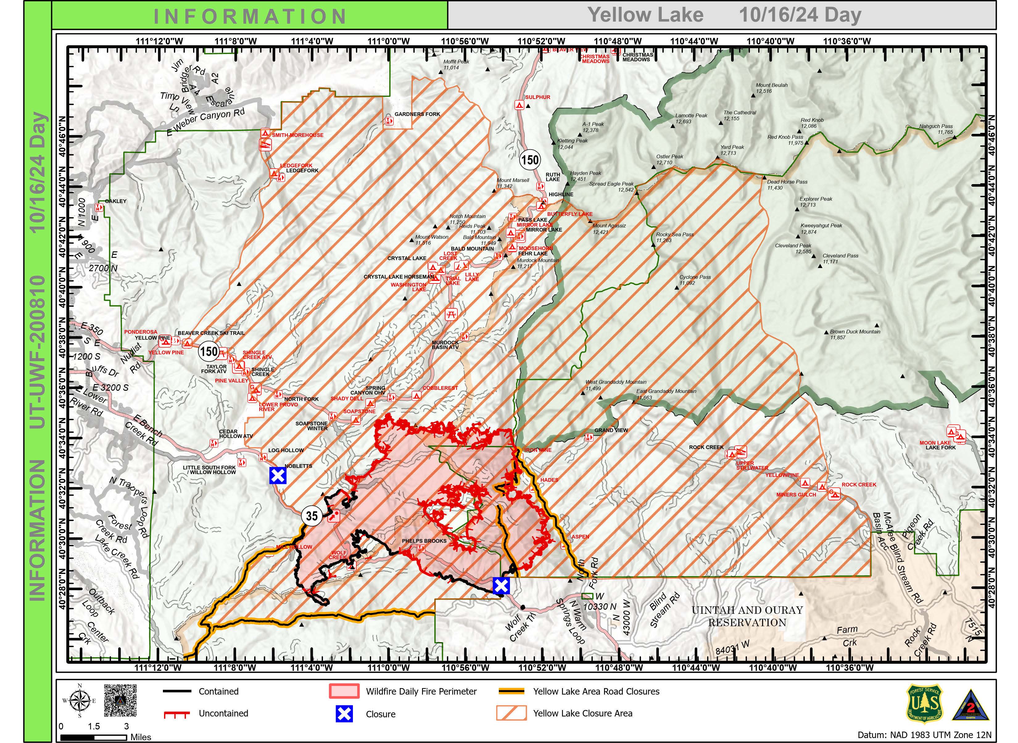
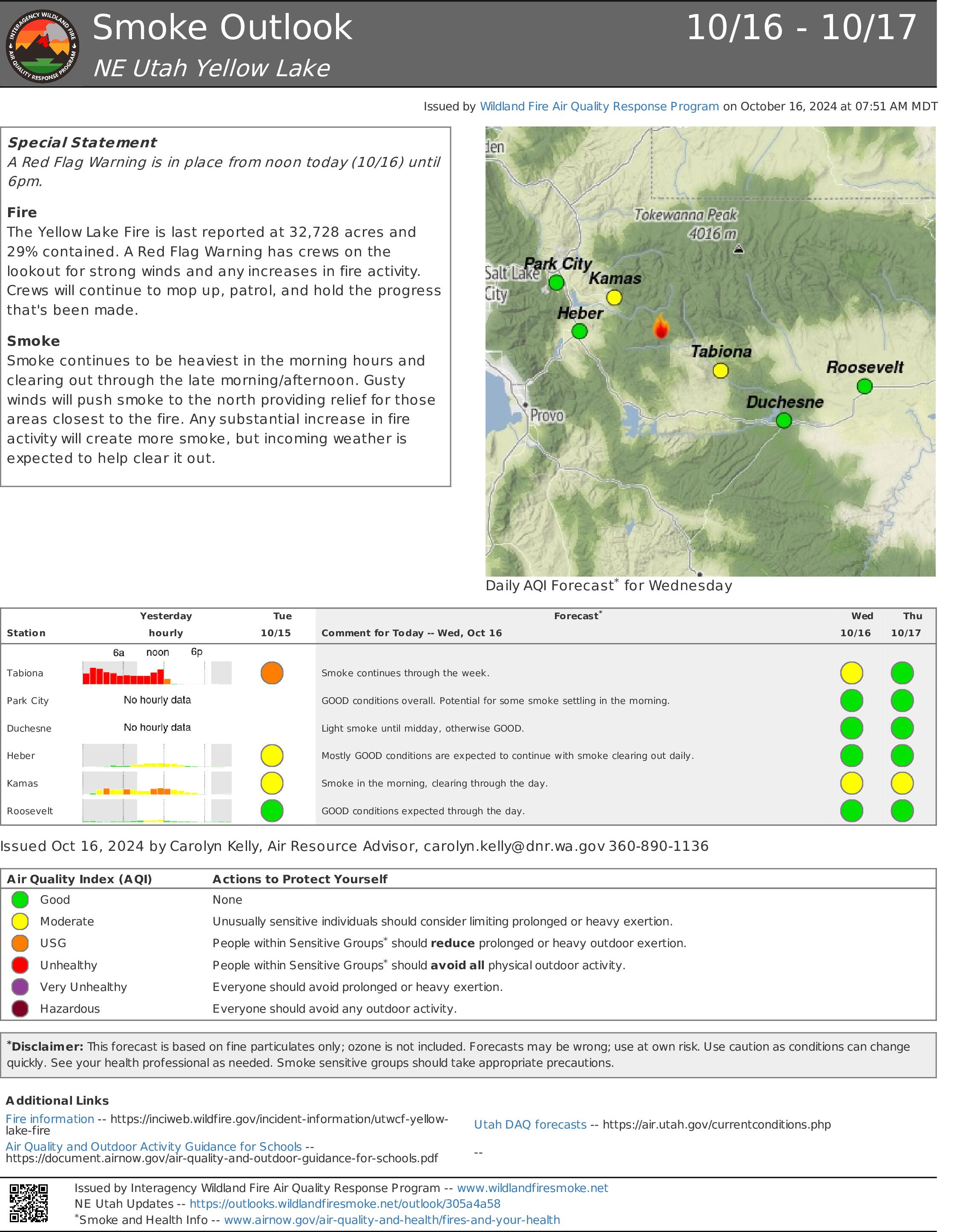
Yellow Lake Fire Update 10 16 2024
Related Incident: Yellow Lake Fire
Publication Type: News
Yellow Lake Fire
Incident Update October 16, 2024
Size at time of update: 32,919
Containment: 29%
Personnel: 779
Start: Saturday, September 28, 2024
Cause: Undetermined
Location: 10 miles southeast of Francis, Utah
An “incident specific” Red Flag Warning is in effect over the Yellow Lake Fire from noon-6:00 p.m. today due to critically dry fuels and weather conditions. Wind, rain, snow, freezing temperatures and thunderstorms with dynamic downburst winds will test the fire perimeter.
Fire managers say the biggest concern is the northwest corner of the fire. Aircraft equipped with infrared technology flew the fire last night and detected intense heat around the “nose” of the fire that extends toward Iron Mine Road. Heat was also detected near Iron Mine Lake and may have crept around rock formations above the lake.
Owners of the Soapstone Summer Homes near Mirror Lake Highway, SR 150 were escorted into the fire closure area early yesterday. Homeowners were able to retrieve personal items and prepare private property for expected freezing temperatures.
Moderate fire behavior was observed overnight within the fire perimeter on the northeast corner near the Wasatch/Duchesne County line. Night crews responded to the central unburned portion of the fire perimeter referred to as the “donut hole.” Three engines and a crew responded to fire activity in this area containing slash piles and logging decks (piles of cut trees that have been stacked). Crews were able to save most of the logging decks, however, one was consumed by flames.
The southern perimeter remains intact with direct and indirect lines, where winds have been favorable this week. Crews observed a few “glows” on the west side last night as interior fuels burned.
Fire impact on watersheds and water quality is being prioritized and mitigated across the entire burn area. Drainage control measures will be implemented to help offset erosion and sedimentation that could originate from the burn scar during periods of heavy precipitation.
A Red Flag Warning will also be in effect across western Utah today.
Forest Closures: All evacuation orders and closures remain in effect.
- Updated October 11, 2024, a closure has been increased on the Uinta-Wasatch-Cache National Forest due to the Yellow Lake Fire. This Order shall remain in effect until October 31, 2024, unless rescinded.
https://www.fs.usda.gov/Internet/FSE_DOCUMENTS/fseprd1208350.pdf - Updated October 11, 2024, a closure has been increased on the Ashley National Forest due to the Yellow Lake Fire. This closure will remain in place through December 31, 2024, or until rescinded, for public safety.
Evacuation Areas: The North and West Forks of the Duchesne River, and Granddaddy Lakes area are under a mandatory GO evacuation meaning all residents, hunters, and recreationists must leave and stay out of the area. Hanna is under a SET order, advising residents to have bags packed and be prepared to evacuate if necessary.
For updated evacuation zones, please visit:
https://emergency-management-operations-wasatch.hub.arcgis.com/
https://tricountyemergencyalert.genasys.com/portal/en
https://www.fs.usda.gov/Internet/FSE_DOCUMENTS/fseprd1208878.pdf
Final Announcement 10 16 2024
Related Incident: Tiger Creek Fire
Publication Type: Announcement
**This is the last Inciweb update unless significant fire activity occurs.**
For all future information on the Tiger Creek Fire, please visit the Umatilla National Forest Service Facebook Page, https://www.facebook.com/UmatillaNF or the Blue Mountain Fire Information Blog at https://bluemountainfireinfo.blogspot.com/
Tiger Creek Fire Daily Update 10 16 2024
Related Incident: Tiger Creek Fire
Publication Type: News
Current Situation: **This is the last update unless significant fire activity occurs. ** For all future information on the Tiger Creek Fire, please visit the Umatilla National Forest Service Facebook Page, https://www.facebook.com/UmatillaNF or the Blue Mountain Fire Information Blog at https://bluemountainfireinfo.blogspot.com/
The Tiger Creek fire remains at 534 acres, containment has increased to 89%, and personnel assigned to the fire now stands at 250. Crews continue to patrol and repair areas within the fire footprint. Due to the containment and weather predicted, many resources will be released this afternoon. California Interagency Incident Management Team 15 will be transferring command of the Tiger Creek Fire at 6pm on October 16, 2024, back to the Umatilla National Forest.
California Interagency Complex Incident Management Team 15 wishes to thank the Umatilla National Forest, Oregon Department of Forestry and Walla Walla Fair & Frontier Days for their friendliness, professionalism, and courtesy during our time on the incident. The team would also like to extend many thanks to the residents affected by the Tiger Creek Fire for their patience, understanding and hospitality over the last two weeks.
Closures and Restrictions: Access through Forest Service Road (FSR) 65 up through FSR 64 to the junction with Indian Camp is closed. Government Mountain Road/FSR 6511 is closed from North Fork Walla Walla trailhead to the junction with FSR 65 at Tiger Saddle. Government Mountain Rd/FSR 6511 is open from the west to North Fork Walla Walla trailhead. The current fire danger rating is MODERATE and public use restrictions phase A for Umatilla National Forest are in effect. For more information regarding restrictions, please contact Umatilla National Forest Toll-free Information Hotline: 1.877.958.9663.
Weather: The weather shifted last night into this morning with 100 percent chance of precipitation continuing into this afternoon. The relative humidity yesterday reached 71 percent and higher winds were recorded. The rain coming in will make for excellent recovery overnight into Thursday. Snow is possible about 3500 feet Wednesday into Thursday.
Smoke: Walla Walla’s air quality for today is good, some residents along Mill Creek may experience smoke as the fire continues to burn. Check out https://wasmoke.blogspot.com/?m=1 for more information.
Logan Fire Daily Update 10 16 2024
Related Incident: Logan Fire
Publication Type: News
Logan Fire Statistics:
Size: 15,836 acres
Completion: 10%
Total Personnel: 249
Weather: The high for today will be around 50-degrees with winds out of the southwest around 8-mph with gusts up to 15-20mph. A strong cold front will pass through the area with increasing cloud cover around noon and winds changing to northwest. Rain is expected on the fire this afternoon and overnight, with snow likely to develop tomorrow.
Current Situation: Yesterday, crews and helicopters used water to cool the fire and keep it away from the structures in the Logan Creek drainage when fire activity in the afternoon. Crews also worked to cool hot areas on the Hogback near the north end of the Big Creek Airstrip. A helicopter carried several loads of equipment from Monumental Airstrip back to the supply area in advance of the approaching storm. Crews wrapped bridges in the Smith Creek area and unwrapped Rabbit Lookout. Today, firefighters will continue to secure and strengthen their containment lines protecting Edwardsburg, and a large contingent will move out of the Big Creek area this afternoon before the storm hits. A hand crew, an engine crew, overhead and others will remain and continue to protect structures in the Edwardsburg and Big Creek Areas.
Evacuations: Logan Fire Edwardsburg Area - The Valley County Sheriff’s Office has placed a "GO" evacuation notice for the Edwardsburg area due to the movement of the Logan Fire. Evacuation orders will be sent out via, CodeRED. Please download the mobile app and sign up. Information is available via the Valley County Idaho website at https://www.co.valley.id.us/WildfireEvacuation or the Valley County Sheriff’s Facebook page, https://www.facebook.com/profile.php?id=100064415776390
Closures: The Logan Fire has a closure around the fire on the Krassel Ranger District and the map and description are located at https://www.fs.usda.gov/alerts/payette/alerts-notices The Sherrif has closed the Warren-Profile Gap Road between Elk Summit and Profile Creek intersection just north of Yellow Pine (this is a County Road). The Big Creek Airstrip is closed.
Elkhorn Fire Update 10 16 2024
Related Incident: Elkhorn Fire
Publication Type: News
Elkhorn Fire Update: 10/16/2024
Thanks to the successful work of all the firefighters who responded to the Elkhorn fire we can announce that the fire is 100% contained as of today.
While the fire is contained, that doesn’t mean that the work is done. Firefighters will continue doing suppression repair work through the coming days.
We would like to thank the Community of Watford City, including businesses and area residents for their heartfelt support throughout the incident.
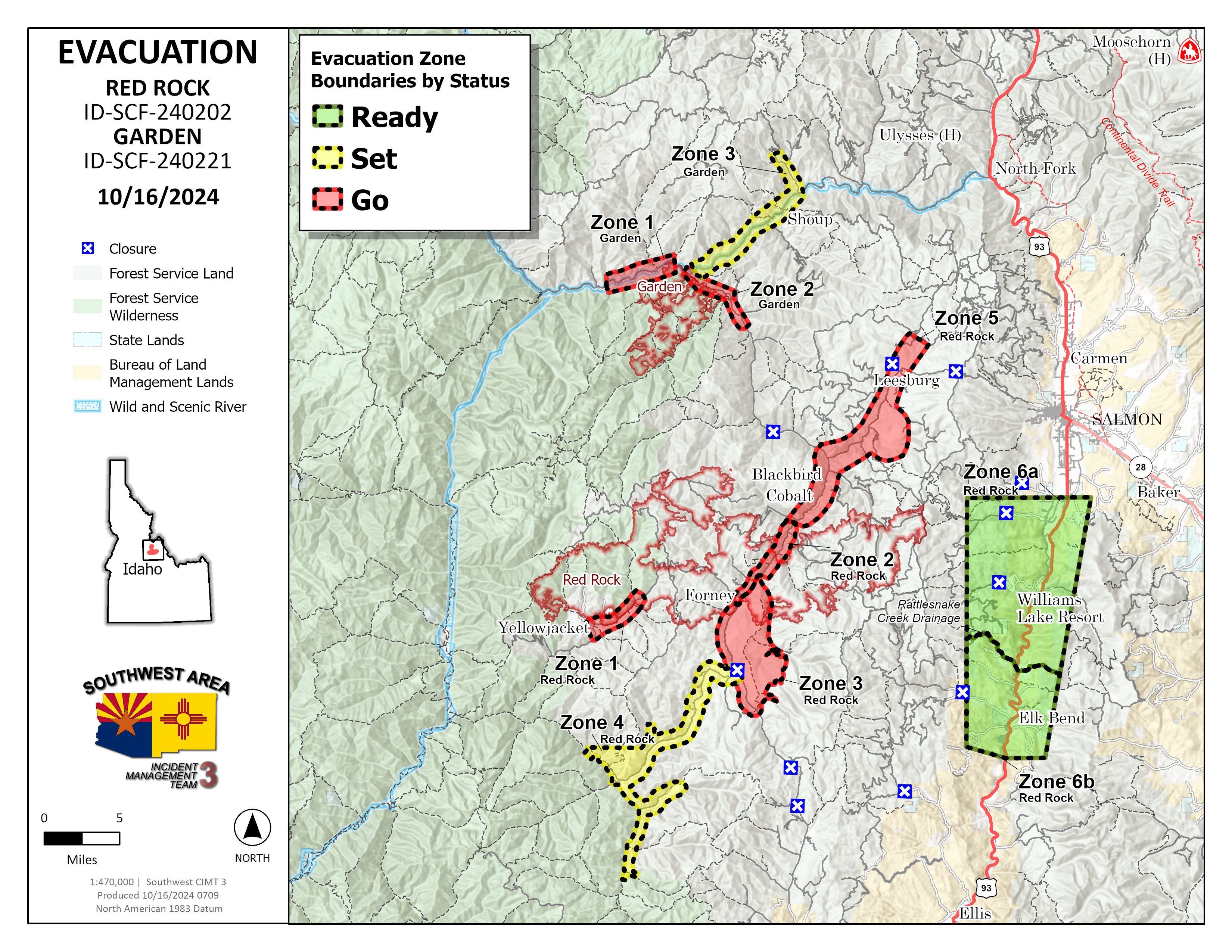
Garden and Red Rock Fires Update 10 16 2024
Related Incident:
Publication Type: News
Cold front likely to bring precipitation tonight
Red Rock Fire
Operations: Yesterday crews checked for hotspots along the handline built off Blackbird Road (FR 115) around the mine. In and around Cobalt, crews built line around some more structures near the Panther Creek Road (FR 055). Uncrewed aircraft applied fire to the interior of the perimeter on the northeast side to remove fuels ahead of the cold front which could bring increased winds. Across the rest of the east and south sides of the fire, heavy equipment and crews strengthened containment lines and mopped up the fire’s edge. Mop up continued on the spot fire in Napias Creek where downed trees have made the task challenging, but there are no concerns for fire growth.
Today, much of the focus will be on the Williams Creek Summit, down the Ridge Road toward Lake Mountain and the dozer line construction off Moyer Peak. With the passage of the cold front, higher west winds will try to push the fire towards the east, making the Ridge Road preparation the focus. Elsewhere across the fire crews are backhauling unnecessary pumps, hose and supplies and preparing other equipment for below freezing temperatures. Firefighters continue to look for and extinguish any remaining heat.
Garden Fire
Operations: Crews continued to monitor, mop up and secure lines particularly in Panther Creek and the Salmon River corridor. There are no additional ignitions planned at this time. Today crews will continue to make sure fire doesn’t spot across the river or move towards the west.
Additional Information
Weather: A vigorous cold front is forecast to travel across the Pacific Northwest on Wednesday. Skies will become mostly cloudy, allowing temperatures to be 5-10 degrees cooler than yesterday with highs in the mid-50s to lower 60s. The relative humidity will be around 10-15 percent higher and around 50 to 35% in the afternoon. Southwest winds will increase during the day with gusts to 20-25 mph along the higher ridges. Rain is forecast to spread across north central Idaho and will develop over Lemhi County in the afternoon. Cold air behind the front will lower snow levels to near 6000 feet Wednesday night down to 5000 feet on Thursday.
Smoke: Information about protecting your health from wildfire smoke is available. A smoke outlook is also available.
Closures: Salmon‐Challis National Forest has implemented a reduced Red Rock and Garden Fires Closure, Order Number: 04‐13‐24‐026. Please refer to the link below to see further information regarding the closure reduction.
Safety: A Temporary Flight Restriction (TFR) is in place over the Red Rock and Garden fire areas, which includes uncrewed aircraft systems or drones. Reminder that if you fly we can’t, unauthorized drone flights pose serious risks to firefighter and public safety and the effectiveness of wildfire suppression operations.
Please stay out of the fire area. There is still active fire behavior in the fire area, including group torching and crown runs. There are multiple roads and bridges that have been destroyed or are impassable. Entry into evacuation zones that are in “Go” status is prohibited. The updated forest closure notice that encompasses both the Red Rock Fire and Garden Fire areas includes multiple road and area closures. Barricade closures will be posted at road intersections and forest boundaries.
Evacuations: For evacuation information in Lemhi County regarding both the Red Rock and Garden fires please go to: https://www.lemhicountyidaho.org/emergency-management-department.
FOREST SERVICE BRIDGE POSTFIRE BAER ASSESSMENT TECHNICALWATERSHED RESPONSE REPORT RELEASED 10 23 2024
Related Incident: Southern California Post-Fire BAER 2024
Publication Type: News
FOREST SERVICE: BRIDGE POST-FIRE BAER ASSESSMENT TECHNICAL-WATERSHED RESPONSE REPORT RELEASED
The Forest Service—Angeles National Forest completed a Burned Area Emergency Response (BAER) post-fire assessment and technical watershed response report for the Bridge burned area and affected watersheds to determine their response, soil conditions, potential threats. The report summarizes the post-fire watershed assessment and expected response.
NOTE: Attached below as “Related Information” is a PDF documents called “BridgeBAER_PostFireTechnicalReport_10222024”.
BAER SAFETY MESSAGE: Everyone near and downstream from the burned areas should remain alert and stay updated on weather conditions that may result in heavy rains and increased water runoff. Flash flooding may occur quickly during heavy rain events--be prepared to act. Current weather and emergency notifications can be found at the National Weather Service website: www.weather.gov/lox/.
Park Fire Final Update 10 16 2024
Related Incident: Park Fire
Publication Type: News
SUSANVILLE, CA, October 16, 2024 — This will be the final update for the Park Fire. The Forest Service’s National Incident Management Organization Team 3 departed at the end of September, transferring incident management to the Lassen National Forest.
The Park Fire is now 100% contained and controlled. The Lassen National Forest continues to work to address threats to public safety resulting from the Park Fire. Through the next few months, the fire will remain in patrol status, resource protection and hazard tree mitigation work will be ongoing as well.
Over the last few months, the Lassen National Forest has completed various suppression repair activities, including hazard trees mitigation and removal, erosion control, watershed repairs, culvert repair and replacement, road blading and repair, and chipping of small materials to clear up woody debris.
There are multiple phases of post-fire actions after a wildfire, from suppression repair through long-term recovery. The Park Fire BAER Assessment Report Summary, completed on September 27, 2024, provided recommendations for the next steps in post fire recovery for your public lands. “As we work through these next phases, we look forward to working with our partners and communities to get the best results for these public lands we manage. Being a good steward is my primary focus as we tackle the difficult work ahead,” said Agency Administrator and Almanor District Ranger, Russell Nickerson.
Lassen National Forest lands, roads, and trails within the Park Fire Closure Area remain temporarily closed for the safety of the public and crews. Prior to recreating on your public lands, check Forest Order No. 06-24-07 and the closure map at fs.usda.gov/alerts/lassen/alerts-notices.
For more information about the Park Fire BAER Assessment visit https://inciweb.wildfire.gov/incident-information/calnf-park-postfire-baer. You can access the latest news and information about the Lassen National Forest at fs.usda.gov/lassen, or by following us on Facebook @LassenNationalForest or X @LassenNF.
###
USDA is an equal opportunity provider, employer and lender.