
Incident Publication
Rail Ridge Daily Update 10 15 2024
Related Incident:
Publication Type: News
Rail Ridge Fire Update
October 15, 2024
Central Oregon Wildfire Information: centraloregonfire.org
Email: 2024.railridge@firenet.gov – Phone: 541-208-7111
Social Media, Evacuation and Closure Information: https://linktr.ee/RailRidgeFire
Acres: 175,060 – Containment: 89% – Detection: 09/02/24 – Cause: Lightning – Personnel: 609
Forest visitors near the Rail Ridge Fire should be aware that Forest and BLM closures as well as fire restrictions around the Rail Ridge Fire remain in place.
NWCIMT8 will be transitioning with NWCIMT2 today at 8pm. Team 8 has appreciated the support of the local landowners, community and agency administrators during their two week assignment on the Rail Ridge Fire. Team 2 personnel arrived yesterday to begin the transition process.
Operational Update: Yesterday, winds and dry conditions caused the fire near Cougar Ridge to increase in activity, causing significant increase of smoke throughout the day. Strong winds with gusts up to 20mph were flowing from the southwest, before shifting from the northwest in the late afternoon. Cloud coverage over the area shaded the fire until about noon, causing temperatures to increase, humidity to drop, and overall fire activity to increase in the northwest. An IR flight over night shows the fire increased by 900 acres. Air resources included four Type 1 helicopters, three air tankers, and an air attack. These resources were utilized to protect the values at risk north of Cougar Ridge where an increase of fire activity was observed by dropping water buckets and retardant. Heavy machinery and crews continued to establish containment line on the northwest section of the fire. Crews continued to patrol the contained perimeter of the fire to locate hot spots, remove debris, and take down hazard trees. While some crews have been moved to the northwest of the fire to assist in containment, fire personnel continued to diligently work on repairing roads throughout the burn area, including FS Road 2150 and 24.
Today, expect to see similar fire activity as yesterday. Fire behavior is expected to increase once the smoke inversion lifts early in the day. Winds will flow in from the southwest in the morning and shift to come from the northwest by this evening. Firefighters are expecting to see an increase of torching and spotting in the heat of the day in the northwest. A change of weather, meteorologists are expecting a 70% chance of wetting rain tonight after midnight. In the highest elevations, this precipitation may appear as snow! Heavy machinery is still being used on the northwest perimeter to establish containment line along FS Road 3850. Fire managers are evaluating the terrain and infrastructure north of the containment lines on the active piece of the fire to install contingency lines. Crews will continue mop and suppression repair along contained edges of the fire. Air resources will continue to be used as needed.
Weather: High pressure will push east later today as low pressure pushed in from the west. Expect increasing clouds by later this afternoon through this evening and a chance of rain after midnight. There will be a few hours of dry conditions this afternoon with min RH down to 25%, and then quickly rise this evening. Winds will be out of the southwest this afternoon and turn west-northwest this evening and tonight with gusts of 12-15 mph. Temperatures will likely dip below freezing Wednesday night into Thursday and light snow will be possible above 4,500 ft elevation.
Forest & BLM Closures / Evacuation Information / Fire Restrictions for the Rail Ridge Fire area can be found at: https://linktr.ee/RailRidgeFire.
Nevada Lake Fire Update 10 15 2024
Related Incident:
Publication Type: Announcement
Location: 8 miles east of Helmville, MT, 0.5 miles north of Nevada Lake
Start Date: 10/14/2024
Cause: Escaped Prescribed Burn
Size: 207 acres
Containment: 0%
CURRENT STATUS
The Nevada Lake Fire is currently 207 acres and actively burning in open grass and heavy timber on the Fish, Wildlife and Parks (FWP) Nevada Lake Wildlife Management Area (WMA) and private land east of Helmville, Montana. Current resources on scene include 11 engines, two dozers, two skidgines, one excavator, and two Type 2 helicopters plus helitack personnel. A Type 3 Incident Commander is enroute, as well as additional helicopters and a Type 2 hand crew.
The wildfire is the result of a FWP escaped prescribed burn ignited on Monday, October 14, north of Nevada Lake on the WMA. The burn was declared a wildfire at approximately 4 p.m. when attempts to control areas where the prescribed fire escaped containment lines were unsuccessful. The DNRC is managing the wildfire response. Initial response efforts to the wildfire included 12 local government engines from four fire departments, four DNRC engines, and one USFS engine. A Very Large Air Tanker (VLAT) dropped two loads of retardant to help slow its progress.
Today, firefighters will focus on protecting values at risk and halting the fire’s forward progress. Ground crews will work on establishing and securing containment lines around the fire’s perimeter, while helicopters drop water on hot spots.
WEATHER AND FIRE BEHAVIOR
Today will be warm and dry ahead of a cold front passing through Wednesday. The front will bring a chance of wetting rains but also an increase in southwest to westerly winds, which could elevate fire behavior. Cooler and showery conditions will continue Thursday, with a chance of snow at 4000 feet.
EVACUATIONS AND CLOSURES
There are no evacuations or closures at this time, but the public is asked to avoid the area. Area residents should be vigilant and remain prepared. For updates, visit https://inciweb.wildfire.gov/incident-information/mtmts-nevada-lake-fireand monitor the Powell County Sheriff's Office Facebook page.
For tips on being prepared for wildfire, please visit https://www.mtfireinfo.org/pages/preparedness.
Shoe Fire Daily Update for 10 15 2024
Related Incident: Shoe Fire
Publication Type: News
Fire Information: 530-338-0317
Media Line: 909-855-4233
Hours: 08:00am to 7:00pm
Location: Shasta County, CA Start Date: Wednesday, October 9, 2024, at 6:57 p.m.
Cause: Human caused Size: 3,559 acres
Percent Contained: 7% Vegetation: Timber, Chapparal
Number of Personnel Assigned: 786
As of October 15, 2024, the Shoe Fire has burned 3,559 acres and remains at 7% containment. Last night, fire activity continued to increase in the South and East sides.
With a forecasted wind event approaching, our team has continued to bring in additional resources in preparation of expected fire growth due to the alignment of topography and weather. Strong winds and steep terrain alignment pose a risk for increased fire activity. Ground crews are working diligently to reinforce control lines along the fires edge utilizing a variety of heavy equipment, aircraft, hand crews, engines and hotshot crews. Additionally, Hirz Bay campground is currently closed to the public and is being used as a base camp for our crews.
Fire weather watch in effect from Thursday through Saturday evening for gusty north to east wind and low humidity. A Pacific storm moves through tonight into Wednesday bringing cooling with increased onshore flow and some precipitation. Gusty and drying northerly wind develops Thursday night into Saturday leading to critical weather conditions.
Mandatory evacuations remain in place for zone LKH-1448-B. Residents who have not evacuated are encouraged to do so. Evacuation information and alerts can be found by visiting protect.genasys.com
Information staff for the Shoe Fire are working diligently to provide timely and accurate information to the public. Fire updates can be found on the Shoe Fire 2024 Facebook page: www.facebook.com/2024ShoeFire/
Additionally, the Shoe fire was named after Shoeinhorse Mountain which is in close proximity to this incident.
WEATHER: The forecast for the area indicates a warming trend over the next few days with increased winds.
EVACUATIONS: Zone LKH-1448-B
ROAD CLOSURES:
- Fenders Ferry Road at Pit River 7 Bridge: West-Bound Fenders Ferry Road (Also known as 34N17 - Forest Service Road 27) at the Pit River Bridge/Pit 7
- Ferry Road is closed at McCloud Bridge: East-Bound Fenders Ferry Road at the McCloud River Bridge
![]() @ShastaTrinityNF
@ShastaTrinityNF ![]() @ shastatrinitynf
@ shastatrinitynf
Email: 2024.shoe@firenet.gov
Incident Website: https://inciweb.wildfire.gov/incident-information/cashf-shoe-fire
Forest Website: https://www.fs.usda.gov/stnf
Fire Weather Forecast: https://www.weather.gov/wrh/CAFW?area=ECC005
Last night, during the evening shift on October 13, activity continues to increase in the Beartrap area.
Additional resources have arrived and been put into place to bolster existing equipment and personnel. Fire fighters have reported successful firing operations along with the utilization of dozer lines in the north and west sides of the fire to create containment lines. The south and east sides of the fire, primarily in the Beartrap creek continue to have an increase in fire behavior. Dozers have had some limited capabilities due to road access. Aircraft and dozer operations will remain a key priority to create access to the south and east sides of the fire. Dozers continue to work to gain better access for direct fire line attack. The safety of our firefighters is priority and they will continue to make progress in a safe manner.
Fire is progressing northward fueled by down slope and down valley winds. Constant changes in wind direction will be observed today along with wind gusts, gusting between 10 to 15 miles per hour.
Mandatory evacuations remain in place for zone LKH-1448-B. Residents who have not evacuated are encouraged to do so. Evacuation information and alerts can be found by visiting protect.genasys.com
Information staff for the Shoe Fire are working diligently to provide timely and accurate information to the public. Fire updates can be found on the Shoe Fire 2024 Facebook page: www.facebook.com/2024ShoeFire/
Additionally, the Shoe fire was named after Shoeinhorse Mountain which is in close proximity to this incident.
WEATHER: The forecast for the area indicates a warming trend over the next few days with increased winds.
EVACUATIONS: Zone LKH-1448-B
ROAD CLOSURES:
- Fenders Ferry Road at Pit River 7 Bridge: West-Bound Fenders Ferry Road (Also known as 34N17 - Forest Service Road 27) at the Pit River Bridge/Pit 7
- Ferry Road is closed at McCloud Bridge: East-Bound Fenders Ferry Road at the McCloud River Bridge
Meridian Daily Update 10 15 2024
Related Incident: Meridian
Publication Type: News
Incident Commander: Derek Wittenberg
Location: Meridian Creek. Approximately 40 miles south of Ennis, MT and approximately 10 miles southwest of
Lyons Bridge on HWY 287.
Start Date: 10/08/2024
Cause: Unknown
Size: Estimated at 1425 acres as of 07:00 PM 10/14/2024
Resources on Site: 1-Type 1 helicopter, 1-20-person hand crew, 4-Type 6 engines.
Total Personnel: 44
The Meridian Fire was reported late in the day on October 8th and is located approximately 10 miles southwest of
Lyons Bridge on HWY 287 in the Meridian Creek Drainage. Fire managers from the Beaverhead-Deerlodge National
Forest have identified and prioritized critical values at risk in the fire area. Firefighting efforts will focus available
resources on the protection of structures approximately ½ mile from the fire.
There are several factors involved in making wildfire management decisions. These factors include, firefighter
safety, resource availability and threats to public safety and property. As well as, terrain, fire behavior, fire season
outlook and modeling, and past prescribed fire units and vegetation management projects in the area. Fire
managers are strategic in their approach and continually reassess conditions and alter management strategies to
protect critical values.
CURRENT STATUS/PLANNED ACTIONS:
The fire doubled in size today after it spotted across FS Trail 6019 and moved to the east/northeast to the top of
Cliff Lake Bench. Resources remained in a safety zone until fire behavior allowed for re-engagement to scout where
the fire had moved to and potential containment features. One Type 1 helicopter was used to drop water were
effective and provided aerial views and information of the fires spread. The rest of the fire showed minimal fire
activity throughout the day. Contact was made with Cliff and Wade Lake Resort in the evening and an assessment
of people in the campground was completed. Madison County Sheriff’s office was updated on the fire situation. A
higher-level Incident Commander, one Air Attack, two Type 1 helicopters, and two engines were ordered.
“Do Not Report” signs remain in place Raynolds Pass and the junction of HWY 87 and HWY 287 by Three Dollar
Bridge to minimize 911 calls impacting Madison County Dispatch. Information boards were updated are still in place
at the MT DOT Rest Area at Lyons Bridge and Cliff/Wade Lake Campground. Barriers remain in place at Hoodoo
Pass and at Miller Flat to reduce ATV/UTV traffic in the fire area. The smoke from this fire along with other fires
west of here will pool in low areas along the Madison and West Fork Madison tonight.
Tomorrow’s actions will involve placing barriers at the junction of FS RD 209 and 1209 (West Fork and Jack Pine)
to limit vehicle traffic to Miller Flat and onto Cliff Lake Bench. Another barrier will be placed at Cliff and Wade Lake
Campground to limit traffic into the campground. Fire resources will be focused on scouting the fire, locating and
assessing values, finding viable features to reduce fire spread, and working available aircraft in areas where they
can be successful.
These actions are designed to allow fire personnel to protect the identified values at risk while operating in areas
that have much better access and egress to safety.
WEATHER AND FIRE BEHAVIOR:
The fire was very active from 03:00 PM until dark burning approximately 700 acres in those four hours. This was
the most activity witnessed on the fire since it started. It is expected to remain active tomorrow on the Cliff Lake
Bench, especially in patches of mature timber while the young lodgepole stands will have reduced fire behavior.
The west aspect between the West Fork Madison and Cliff Lake Bench will have active fire behavior through the
afternoon as well.
Tomorrow’s forecast will be similar to todays weather. Wednesday, 10/16 is when the next significant weather
change is forecasted. This will bring the potential for strong, gusty winds up to 35 mph followed by a chance of
rain and snow Thursday and Friday. After that it is forecasted to remain cold with low temperatures in the teens
and low 20s into 10/26.
CLOSURES AND RESTRICTIONS:
There are no fire restrictions on the Beaverhead-Deerlodge National Forest, or any area closures pertaining to the
Meridian Fire.
Bighorn National Forest Order No 0202062408 signed 10 14 2024
Related Incident: Elk Fire 2024
Publication Type: Closures
U.S. Department of Agriculture, U.S. Forest Service
Bighorn National Forest
Tongue and Medicine Wheel Ranger Districts
Fire Area Closure
PROHIBITIONS
Pursuant to 16 U.S.C. § 551 and 36 C.F.R. § 261.50(a) and (b), the following are prohibited on the National Forest System (NFS) lands in the Tongue and Medicine Wheel Ranger Districts, Bighorn National Forest, described below and shown on the attached map incorporated into this Order as Exhibit A (the “Described Area”):
1. Going into or being upon the Described Area. 36 C.F.R. § 261.53(e).
EXEMPTIONS
Pursuant to 36 C.F.R. § 261.50(e), the following persons are exempt from this Order:
1. Persons with Forest Service Permit No. FS-7700-48 (Permit for Use of Roads, Trails, or Areas Restricted by Regulation or Order), specifically exempting them from this Order or a written determination by a Forest Service authorized officer that a permit is not required under 36 C.F.R. § 251.50(e)(1) or (2).
2. Any Federal, State, or Local Officer, or member of an organized rescue or firefighting force in the performance of an official duty.
DESCRIBED AREA
The Described Area starts at the northeastern boundary of the Bighorn National Forest where Forest Road 111, Red Springs Road leaves the Forest. It follows the Forest Boundary east then south-southeast to the location Forest System Road 319 enters the Forest. Then following and including Forest System Road 319 to its end where it meets Forest System Trail 200. Then following and including Forest System Trail 200 south along Willow Park Reservoir to Forest System Trail 038. Then following Forest System Trail 038 west-northwest to the Cloud Peak Wilderness boundary. Then following the northern wilderness boundary to the Sheridan County/Big Horn County line near Woodchuck Pass. Then following the county line northwest to where it crosses Forest System Road 226. Then following and including Forest System Road 226 north to where it meets Forest System Road 26. Then following and including Forest System Road 26 west-northwest to Highway 14. Then turning north following Highway 14 to
Order Number: 02-02-06-24-08
Burgess Junction. Then to the west following Highway 14A to Forest System Road 14. Then turns north following and including Forest Road 14 north to Forest System Road 11. Then following and including Forest System Road 11 north-northwest to Forest System Road 111. Then following and including Forest System Road 111 northeast to the Forest Boundary.
This closure includes all National Forest System Roads and Trails within the Described Area.
PURPOSE
The purpose of this Order is to protect firefighter and public safety during the response to the Elk Fire.
IMPLEMENTATION
1. This Order shall be in effect from October 14, 2024 at 08:00 a.m. through December 31, 2024, at 12:00 a.m., unless rescinded.
2. A map identifying the Described Area, Roads, and Trails is attached and made part of this Order as Exhibit A. For a digital version of this Order and Exhibit A, go to https://www.fs.usda.gov/detail/bighorn/alerts-notices/?cid=fseprd1090225.
3. Unless otherwise expressly defined in this Order, the terms used in this Order are defined by the regulations of the Secretary of Agriculture, 36 C.F.R. Chapter II, Parts 200-299. If there are terms in this Order that are not expressly defined in the Order or 36 C.F.R. Chapter II, Parts 200-299, their meaning shall be determined by their plain language definitions.
4. A violation of the above prohibitions is punishable as a Class B misdemeanor by a fine of not more than $5,000 for individuals and $10,000 for organizations, or by imprisonment for not more than six months, or both. 16 U.S.C. § 551; 18 U.S.C. §§ 3559, 3571, and 3581.
5. Contact the Bighorn National Forest Supervisor’s Office in Sheridan, Wyoming, (307) 674-2600, for more information about this Order.
6. This Order supersedes any previous Orders prohibiting the same or similar acts in the same Described Area.
Signed and issued on October 14, 2024.
____________________________________________
Andrew K. Johnson, Forest Supervisor
Bighorn National Forest
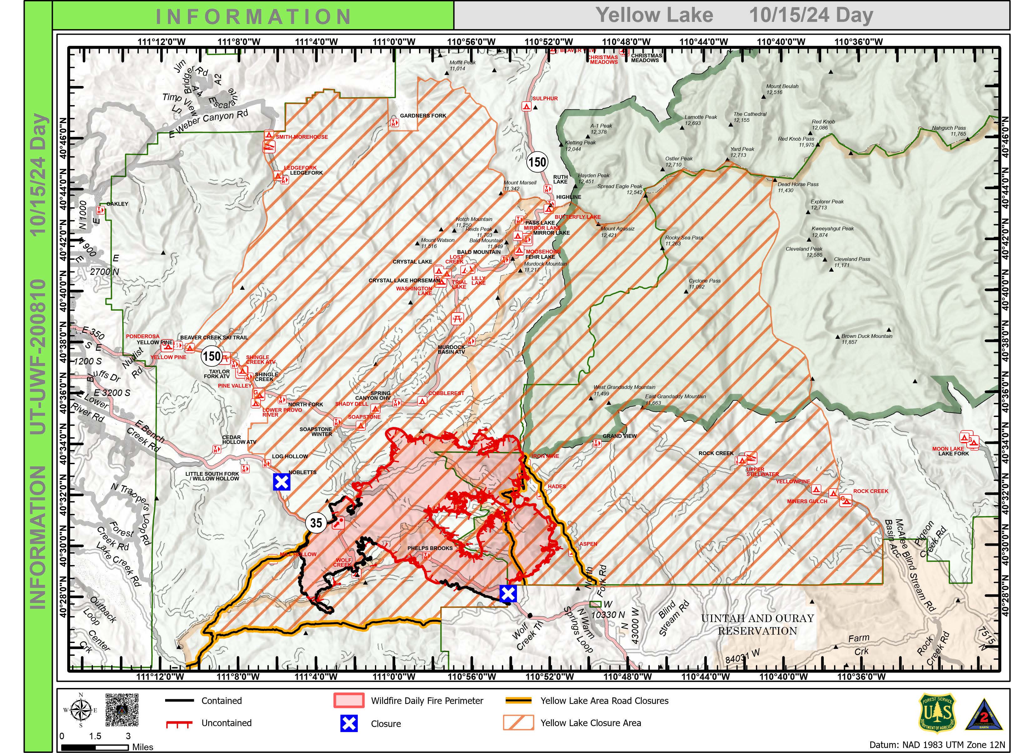
Yellow Lake Fire Update 10 15 2024
Related Incident: Yellow Lake Fire
Publication Type: News
Yellow Lake Fire
Incident Update October 15, 2024
Size at time of update: 31,193
Containment: 29%
Personnel: 889
Start: Saturday, September 28, 2024
Cause: Undetermined
Location: 10 miles southeast of Francis, Utah
The most active part of the fire occurred in the northwest finger as burning snags continued to glow overnight. Jackpot fuels occasionally flared in the Iron Mine Lake area. Fire managers praised the Uinta-Wasatch-Cache National Forest on previously completed fuel thinning projects. The fuel breaks slowed fire progression and currently have it in a backing alignment. The multi-year project was implemented to reduce fuels along both sides of Mirror Lake Highway. Water-scooping airplanes and helicopters will continue operations today, dropping water to further cool the fire’s northern edge. Dozers are also reinforcing lines in the area in addition to hand crews.
Some flanking was observed on the east side of the Fire. Along the North Fork of the Duchesne River, the fire continued to slowly back down the slope toward the river. One finger of the fire reached the bottom of the slope near the river, forming an anchor point for fire crews to work from while protecting nearby properties. Crews are employing a point-protection strategy, setting up pumps, hoses, and sprinklers on structures along the North Fork.
On the southeast edge of the fire, dozer and hand crews are constructing a secondary control line away from the fire’s edge running from the West Fork of the Duchesne to the Lookout Mountain area. Dozers are pushing additional fire breaks along Wolf Creek Road while avoiding hazard trees.
Patrol continues on the western flank of the fire, from East Fork Mill Hollow up to Soapstone Mountain, although there has been no recent fire activity. Chipping and fuel removal along the control line is progressing in this area.
All control lines will continue to be strengthened today anticipation of stronger winds on Wednesday followed by a cold front and predicted rain and snow starting Thursday.
All evacuation orders and closures remain in effect.
Forest Closures:
- Updated October 11, 2024, a closure was increased on the Uinta-Wasatch-Cache National Forest due to the Yellow Lake Fire. This Order shall remain in effect until October 31, 2024, unless rescinded. https://www.fs.usda.gov/Internet/FSE_DOCUMENTS/fseprd1208350.pdf
- Updated October 11, 2024, a closure was increased on the Ashley National Forest due to the Yellow Lake Fire. This closure will remain in place through December 31, 2024, or until rescinded, for public safety.
Evacuation Areas: The North and West Forks of the Duchesne River, and Granddaddy Lakes area are under a mandatory GO evacuation meaning all residents, hunters, and recreationists must leave and stay out of the area. Hanna is under a SET order, advising residents to have bags packed and be prepared to evacuate if necessary.
For updated evacuation zones, please visit:
https://emergency-management-operations-wasatch.hub.arcgis.com/
https://tricountyemergencyalert.genasys.com/portal/en
https://www.fs.usda.gov/Internet/FSE_DOCUMENTS/fseprd1208878.pdf
Valley Fire Update 10 15 2024
Related Incident: 2024 Valley Fire
Publication Type: News
Incident Activity: There are still hot spots on the north/northeast portion of the fire closest to Robie Creek. Helicopter water drops Monday helped ground crews address areas of remaining burning fuels. Crews continue with mop up and are monitoring containment lines. Fire activity remains a safe distance from the community. Crews continue to monitor the south and west portions of the fire burn area visible from Boise.
Repair of Fire Suppression Activity: Crews are shifting from fire suppression to suppression repair. There are 22 miles of dozer line that were put in place to prevent the Valley Fire from reaching homes near the Boise Foothills as well as handline built by firefighters on the ground. Suppression repair includes using excavators to bring containment lines back to a more natural ground surface that is ready for vegetation regrowth. About 2 miles have been completed so far.
No Fly Zone: Helicopter water drops may still be needed for the Valley Fire. Please remember, flying drones in the fire area is NOT ALLOWED. Drones pose a safety risk for firefighting aircraft and medical rescues that require an airlift.
Recreation Message: The public is asked to be aware of closures prior to being in the area and honor closures. Closures are in place for public safety. Even if there is no visible fire activity, there could be hot spots, damaged trees that could fall, fire traffic on narrow dirt roads, and other safety concerns.
Closures and Evacuation Status: All roads and trails on the Boise Front segment of the Boise River WMA west of Highway 21 and north of Warm Springs Avenue are closed to all entry until further notice. This closure also extends to all travel off roads and trails. The Robie Creek area is still in a "Ready" or Stage 1 evacuation status.
Weather: Warmer today with highs averaging 75 degrees in the Valley Fire area. Winds will be at 8 mph potentially reaching 12 mph in the afternoon.
Valley Fire Overview: The fire was reported Friday, October 4, 2024, about 1 mile east of Boise on the north side of Idaho State Highway 21. The fire was very visible from East Boise as it burned in mostly grassy fuels in the Boise Foothills. Quick work on initial attack stopped the fire from reaching nearby homes. No injuries have been reported or primary residences lost. The current fire cost estimate is $3 million.
New Pack Trail Forest Closure Order 040324317 in Effect from October 14 2024 through November 15 20204 10 15 2024
Related Incident:
Publication Type: News
All National Forest System Lands, roads and trails within the described area as shown on Exhibit A Pack Trail Fire area, road, and trail closure map are closed.
PURPOSE
The purpose of this Order is to protect public safety during Pack Trail Fire.
IMPLEMENTATION
1. This Order shall be in effect from October 14, 2024, at 12:00 P.M. through November 15, 2024, at 12:00 A.M., unless rescinded.
2. A map identifying the Described Area/Roads/Trails is attached and made part of this Order as Exhibit A. For a digital version of this Order and Exhibit A, go to https://www.fs.usda.gov/alerts/btnf/alerts-notices
3. Unless otherwise expressly defined in this Order, the terms used in this Order are defined by the regulations of the Secretary of Agriculture, 36 C.F.R. Chapter II, Parts 200-299. If there are terms in this Order that are not expressly defined in the Order or 36 C.F.R. Chapter II, Parts 200-299, their meaning shall be determined by their plain language definitions.
4. A violation of the above prohibitions is punishable as a Class B misdemeanor by a fine of not more than $5,000 for individuals and $10,000 for organizations, or by imprisonment for not more than six months, or both. 16 U.S.C. § 551; 18 U.S.C. §§ 3559, 3571, and 3581.
5. Contact the Jackson Ranger District in Jackson, WY, (307) 739-5400, Pinedale Ranger District in Pinedale, WY, (307) 367- 4326 and Bridger-Teton National Forest Supervisor’s Office in Jackson, WY, (307) 739- 5500, or the Wind River Ranger District in Dubois, WY, (307) 455-2466 for more information about this Order.
6. This Order supersedes any previous Orders prohibiting the same or similar acts in the same Described Area.
Signed and issued on October 14, 2024.
Pack Trail Daily Update October 15 2024 10 15 2024
Related Incident:
Publication Type: News
Pack Trail Daily Update October 15, 2024
Total Acres: 86,555
Confined: 62%
Total Personnel: 613
CACIMT10 will transition command of the fire to Great Basin CIIMT5 at 0700 tomorrow, October 16th.
Operations – Today, shifting winds, picking up in the afternoon, will likely lead to increased fire activity. Yesterday, on the east side of the fire, ground crews secured hot spots along the 540 Road, continued cleaning up containment lines along Trout Creek. On the South side, the Pack Trail Fire continued to slowly move into areas around Cowboy Camp, Strawberry Warming Hut, and Fish Creek Guard Station. Firefighters utilized aircraft to suppress hot spots, while mopping up, patrolling, maintaining and testing sprinkler systems set up around homes and other values at risk. The fire remains confined north of Union Pass Road. On the west flank, in the Gros Ventre River Basin, firefighters are patrolling the Burnt Ridge area and also using aircraft to slow the fire’s incursion into the valley. There has been a major effort to prepare and protect a stand of endangered White Bark Pine. The structure protection group continues wrapping buildings in protective foil, laying hose lines, and setting up sprinkler systems around additional structures. Night crews continue to patrol accessible areas of the fire and reported there was minimal fire activity in the interior and nothing that threatened the containment lines overnight.
Safety – Teton Interagency Fire managers are maintaining the Very High Fire Danger Rating for Grand Teton National Park, the Bridger-Teton National Forest, the Shoshone National Forest, and the National Elk Refuge. Please use caution while driving these areas, especially on narrow secondary roads. Always expect to encounter fire vehicles and heavy equipment in and around the fire area. Check with WY-DOT for possible closures due to fire activity, especially if you are planning to travel on US-26 across the Continental Divide. Due to excessively dry fuels, any spark can ignite fire which can grow rapidly into a major incident. Residents and visitors are urged to exercise extreme caution with fires or other possible ignition sources. Always build campfires away from dry grass, leaves, and overhanging branches to reduce the risk of spreading wildfire. Clear at least a 10-foot perimeter around your fire, removing any flammable material, and have enough water on hand to ensure your fire is dead out and cool to the touch before you go to sleep or leave the area.
Remember that flying a personal drone over a fire area during a temporary flight restriction is illegal and can be an extremely dangerous threat to both our aviators and firefighters on the ground. “If you fly, we can’t.”
Weather – Today’s weather conditions present the potential for increased fire behavior in the afternoon as winds shift directions coming from the SW at 8-12 MPH, with gusts reaching up to 20 MPH. The forecast calls for high temps in the 60’s and relative humidity between 18% and 22%.
Smoke will be a factor in many areas surrounding the fire. To learn more about air quality, visit Fire.AirNow.Gov.
Evacuations – Brooks Lake Lodge, Pinnacle Cabins, Falls Camp, and Long Creek have been reduced to a Level 2 “Set” Evacuation Warning. Level 3 “Go” evacuation orders remain in effect for Lava Mountain Lodge and McKenzie Highland Ranch. The Dunoir Road Corridor has been reduced to a Level 1 “Ready” Evacuation Warning. See the Fremont County Emergency Management Facebook Page for alerts and updates. See the Teton County Emergency Management website updates and to sign up for emergency alerts through Everbridge.
Road Closures – The Union Pass Road is closed on the Pinedale District (BTNF) from Mosquito Lake to the DuNoir on the Wind River District (SHO).
Forest Closures - Closure Order #04-03-24-317 is in effect from October 14, 2024 at 12:00 p.m. through November 15, 2024 at 12:00 a.m. unless rescinded. This order supersedes previous orders, including #04-03-24-316, prohibiting the same or similar acts in the same described area.
For more information, visit: Facebook: USDA Forest Service - Bridger-Teton National Forest, USDA Forest Service - Shoshone National Forest Pack Trail Inciweb: https://inciweb.wildfire.gov/incident-information/wybtf-pack-trail-fire
Elk Fire Update 10 15 2024
Related Incident: Elk Fire 2024
Publication Type: News
Elk Fire Update – October 15, 2024
Rocky Mountain Area Complex Incident Management Team 3
Casey Cheesbrough, Incident Commander
Size: 91,905 acres (2,590-acre increase)
Total Personnel: 939
Containment: 26 percent
Cause: Lightning
Resources: 13 aircraft | 19 crews | 67 engines | 8 dozers | 19 water tenders | 5 masticators | 8 skidders | 5 feller bunchers 4 processor | 3 chippers
Key Messages: Expect increased fire activity and smoke today because of unseasonably warm temperatures, low humidity, and extremely dry fuels.
The Sheridan County Sheriff’s Office released updates to evacuation statuses and road closures yesterday. Evacuation status for an area southwest of Dayton near Horseshoe Road changed from Go to Set, allowing residents to return to the area. Some roads near Dayton, Parkman, and Sheridan were re-opened to the public. For more detailed information about evacuation statuses and road closures go to the Sheridan County Emergency Management website: tinyurl.com/2s38bcc5.
Wyoming Department of Transportation (WYDOT) opened portions of US 14 and US 14A previously closed due to the Elk Fire. WYDOT opened US 14 from Greybull to Burgess Junction and US 14A from Burgess Junction to Lovell.
US 14 from Burgess Junction east to Dayton remains closed. View the WYDOT road-closure map here: wyoroad.info.
Current Situation: Warm, dry conditions yesterday intensified fire activity. Along the southern edge, the fire continued to move southeast toward the seven-mile-long control line that was created over the last several days. Overnight, it crossed Rapid Creek. Night operations inserted a hotshot crew, that created handline to slow the fire’s forward progression at the Forest Service Trail 238.
Further south of the fire, crews continued the ongoing work of widening and clearing trees and vegetation with heavy equipment along Red Grade Road. Today, additional crews from the recently completed chipping operations along the 144 Road north of the fire will join in the work along Red Grade Road.
Crews continue to improve structure protection in the Burgess Junction area, while also using heavy equipment to widen and clear the 15 and 16 Roads to create a box of fireline around the area.
An aerial reconnaissance flight detected some fire activity in the northwest corner of the fire yesterday. Crews worked quickly to create a control line and secure the area. Patrols will continue in the northwest corner of the fire, along the north side near the 144 Road, and along the containment line on the eastern side of the fire to mop-up any hotspots.
Weather & Fire Behavior: Today’s temperatures will be up to 20 degrees higher than normal for this time of year and will combine with relative humidity as low as 16 percent to produce a high probability of significant fire activity and smoke production. For air-quality and smoke information, go to airnow.gov.
Evacuations and Closures: For information on Johnson County evacuations, go to Johnson County Emergency Management’s Facebook page: facebook.com/JohnsonCoWYEMC. For info on Sheridan County evacuations and road closures, go to the Sheridan County Emergency Management website: tinyurl.com/2s38bcc5. You can also call the Sheridan County Sheriff’s Office (307-672-3455) or Sheridan County Emergency Management (307-752-2174). The Red Cross has an evacuation center at the Sheridan County Fairgrounds that can accommodate people, RVs/campers, pets, and livestock. Call 307-752-2174 or 307-683-6965 to make arrangements. US Highway 14 is closed between Burgess Junction and Dayton. View the Wyoming Department of Transportation road-closure map here: wyoroad.info. Bighorn National Forest closure has been expanded to include Forest System Roads 319 and a portion of 226 and Forest System Trail 200 and a portion of Trail 038 under Order 02-02-06-24-08. The order and map can be viewed here: fs.usda.gov/alerts/bighorn/alerts-notices.
Elk Fire Information:
Phone: 307-303-7642 (8 am to 8 pm)
Email: 2024.Elk@firenet.gov
Linktree: linktr.ee/2024ElkFire