
Incident Publication
Quick Facts Birch Fire October 13 10 13 2024
Related Incident:
Publication Type: News
October 12, 2024: The Inversion did not lift over the Birch Fire area. Between 3:30 pm and 4:30 pm, there was some clearing of the skies but not over the fire area. At 5:00 pm, the inversion settled back in over the area. Minimal fire activity in the East Fork of Indian Creek, fire is burning the upper third of the west side of the drainage. There was an infrared flight from last night, updated acres is 21,729 acres. Growth was in Indian Creek with the rest of the fire showing little activity.
Elkhorn Fire Update 10 13 2024
Related Incident: Elkhorn Fire
Publication Type: News
On Saturday, firefighters continued to work hot spots mainly in the interior of the fire area. The work that the firefighters completed over the past week was tested by the higher winds. Their efforts proved to be successful as the fire lines held.
Today, there in an increase in containment to 75%.
In the coming days, Suppression Repair work will begin in some areas. Suppression repair is the work done to repair or minimize the fire impacts to resources and lands that resulted from firefighting activities.
Elkhorn Fire Update 10 12 2024
Related Incident: Elkhorn Fire
Publication Type: News
It’s been a long week, and it’s one of the few remaining warm weekends before winter blows across the land. If you’re thinking about getting out for some well-deserved recreational activities this weekend, we’re with you! Great!
However, due to current severe fire dangers and ongoing fire operations, such as the Elkhorn Fire blazing throughout the western North Dakota region, recreational activities are restricted.
For instance, travel by all-wheeled motor vehicles on non-surfaced (Prairie Two-track) National Forest System Roads is currently prohibited as per the DPG’s Emergency Fire Order and Restrictions.
Additionally, activity restrictions and exemptions exist for building, maintaining, attending, or using a fire, campfire, or stove fire.
However, there are conditional provisions for liquid petroleum stoves and grills and set conditions for smoking in designated spaces.
To read the official Order, view the accompanying map, or find more helpful DPG information, please visit our website: https://www.fs.usda.gov/alerts/dpg/alerts-notices/?aid=91474
Please be careful out there and if you detect any fire, please call 911 immediately so the amazing first responders can do what they do best!
Thank you for your support and patience, and have a safe, awesome, and fun-filled weekend!
Sheridan County Evacuation Information 10 12 2024
Related Incident: Elk Fire 2024
Publication Type: Announcement
For the most recent up-to-date evacuation information, visit Sheridan County Emergency Management's news listing webpage.
Forest Service Closure Reduced 10 12 2024
Related Incident:
Publication Type: Closures
RED ROCK AND GARDEN FIRE CLOSURES REDUCED
OCTOBER 12, 2024
The Central Idaho Dispatch Zone is at HIGH Fire Danger
Fire behavior has moderated on the Red Rock and Garden Fires. With the changed weather and fire behavior, the Salmon-Challis National Forest has implemented a reduced Red Rock and Garden Fires Closure, Order Number: 04‐13‐24‐026 as of 8:00 pm, today, Saturday, October 12, 2024.
Description of #04-13-24-026 (effective as of 8:00pm, Saturday, October 12, 2024):
DESCRIBED AREA/ROADS/TRAILS
Beginning at Ebenezer Bar on the Salmon River Road 030 south from Ebenezer Bar to Dome Mountain and continuing south to Big Deer Creek Trail 029 on Big Deer Creek, then west and south to Big Horn Crags Campground and Yellowjacket Lake Campground. Then following south on Hoodoo Creek Trail 107 to where it meets the Frank Church River of No Return Wilderness Boundary. Then following south from the Frank Church River of No Return Wilderness Boundary to where it meets Yellow Jacket Road 112. The following Yellow Jacket Road 112 and Little Yellow Jacket to where it meets Duck Point Road 201. Then following Duck Point Road 201 to where it meets Birdseye Creek. The following Birdseye Creek west to where it intersects Silver Creek Road 108. The following Silver Creek Road 108 to where it meets Morgan-Panther Creek Road 055. The following Morgan-Panther Creek Road 055 to where it meets Opal Creek Road 252. Then following Opal Creek Road 252, Moyer Creek Road 103, and the South Fork of Moyer Creek to Taylor Mountain. Then following the ridge north and east to Iron Lake Campground and along Iron Creek to where it meets the West Fork Iron Creek Road 046. Then following West Fork Iron Creek Road 046 and Iron Creek Road 045 to the boundary of the Salmon Challis National Forest. Then following the Forest Boundary north to its intersection with the Leesburg Stage Road 002, along this road to the Ridge Road 020, then on Sharkey Creek Road 272 to Leesburg, then due west from Leesburg to its intersection with Jureano Mountain Road 300, then along this road to its intersection with the Moose Creek Road 061, then on Jureano Lookout Road 325 following this road to its end on Trapper Ridge. Then following Trapper Gulch to its junction with Morgan-Panther Creek Road 055. Then following Morgan-Panther Creek Road 055 to its junction with Salmon River Road 030. Then following Salmon River Road 030 to its junction with Ebenezer Bar.
The purpose of this order is to protect public health and safety from the effects of the Red Rock and Garden Fires.
This Order shall be in effect from October 12, 2024, at 8:00 pm until October 31, 2024, or until rescinded.
Shoe Fire Daily Update for 10 12 2024
Related Incident: Shoe Fire
Publication Type: News
Location: Shasta County, CA
Start Date: Wednesday, October 9, 2024, at 6:57 p.m.
Cause: Under Investigation
Size: 2,304
Percent Contained: 0%
Vegetation: Timber, Chapparal
Number of Personnel Assigned: 418
As of October 12, 2024, the Shoe Fire has burned 2,304 acres and remains at 0% containment. Last night, during the evening shift on October 11, fire behavior was moderated due to increased precipitation.
Complex California Interagency Incident Management Team 13 has taken command of the fire as of 7:00 a.m., October 12, 2024.
Firefighters are combating the fire, which is currently advancing northeast along the Sulanharas drainage. Due to the steep and rugged terrain, aerial resources are the primary focus, with water-dropping operations set to continue throughout the day. Ground crews are diligently working to establish containment lines to support full suppression efforts. Structure protection measures are in place, with firefighters prepared to respond swiftly if the fire threatens any residences.
Fire is predominantly moving northward, fueled by timber in the challenging landscape. While extreme wind patterns are not anticipated in the area, any moisture recovery from the previous operational period may diminish due to rising temperatures and low relative humidity expected throughout the day.
There is currently a mandatory evacuation in the Lakehead area in zone LKH-1448-B. Residents are urged to evacuate immediately as there is imminent fire danger. Evacuation information and alerts can be found by visiting protect.genasys.com
The information staff of the Shoe Fire are working diligently to provide timely and accurate information to the public. Fire updates can routinely be found on the dedicated Shoe Fire 2024 Facebook page: www.facebook.com/2024ShoeFire/
WEATHER: The forecast for the area indicates a cooling trend over the next few days, along with a possibility of rain.
EVACUATIONS: Zone LKH-1448-B
ROAD CLOSURES:
- Fenders Ferry Road at Pit River 7 Bridge: West-Bound Fenders Ferry Road (Also known as 34N17 - Forest Service Road 27) at the Pit River Bridge/Pit 7
- Ferry Road is closed at McCloud Bridge: East-Bound Fenders Ferry Road at the McCloud River Bridge
Garden Fire Closure Order Lifted 10 12 2024
Related Incident:
Publication Type: Closures
GARDEN FIRE CLOSURE #04-13-24-025 TERMINATED
Release Date: Oct 12, 2024
Fire behavior has moderated on the Garden Fire and the risk of the fire spotting across the Salmon River has been reduced. With the changed weather and fire behavior, the Salmon‐Challis National Forest has terminated the Garden Fire Closure, Order Number: 04‐13‐24‐025.
The following description of #04-13-24-025 is now open:
DESCRIBED AREA, ROADS AND TRAILS (now open):
Beginning at the junction of Salmon River Road 030 and Spring Creek Road 038 and following Spring Creek Road 038 to its junction with Colson Creek-State Line Road 123, then following Colson Creek-State Line Road 123 to its junction with Long Tom Road 166, the following Long Tom Road 166 to Long Tom Lookout, then following the ridgeline south to Long Tom Picnic Area, then following the Salmon River Road 030 back to its junction with Spring Creek Road 038.
Corn Lake Road 064, East Fork of Spring Creek Road 042, and Cadagan area are also closed.
The forest is asking visitors to be aware of the HIGH fire danger for the Salmon-Challis National Forest. Ensure your campfire is dead out. If it is too hot to touch, it is too hot to leave! One Less Spark Means One Less Wildfire.
Visit the Salmon Challis NF: www.fs.usda.gov/scnf/ for more information
Yellow Lake Fire Update 10 12 2024
Related Incident: Yellow Lake Fire
Publication Type: News
Yellow Lake Fire
Incident Update October 12, 2024
Size at time of update: 26,197
Containment: 21%
Personnel: 848
Start: Saturday, September 28, 2024
Cause: Undetermined
Location: 10 miles southeast of Francis, Utah
Full suppression strategy continues today on the Yellow Lake Fire using ground crews, supported by numerous aircraft. Five scooper planes worked throughout the day on Friday dropping water to slow fire progression on the east side of the fire. Retardant drops were also used where needed. This allows ground crews to safely enter more active portions of the fire. Dozer and hand lines can then be constructed down to the soil level where water and retardant often cannot reach due to tree canopy, brush, ground litter, and other obstructions. The north and east sides remain most active and are the current priorities.
Eight log decks have been destroyed within timber sale areas. They are considered “structures” according to reporting requirements but, no building structures have been damaged to date.
Fire crews were able to catch a spot fire overnight on Iron Mine Mountain. This fire line is being reinforced today.
Burning snags, isolated interior torching and wind driven runs will occur today as southwest winds dominate fire behavior. Smoke plumes are anticipated. Wind direction should be favorable on the south edge of the fire. Increased spotting potential could occur today if opposing canyon winds in the North Fork of the Duchesne drainage clash with southwest winds.
Minimal activity has been observed on the west side of the fire perimeter.
A public meeting to present information on the Yellow Lake Fire is planned for 3:00 p.m. on Sunday, October 13th, at the Kamas Middle School Auditorium.
Forest Closures:
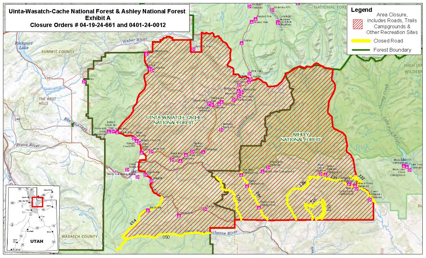
- Updated October 11, 2024, a closure has been increased on the Uinta-Wasatch-Cache National Forest due to the Yellow Lake Fire. This Order shall remain in effect until October 31, 2024, unless rescinded.
https://www.fs.usda.gov/Internet/FSE_DOCUMENTS/fseprd1208350.pdf - Updated October 11, 2024, a closure has been increased on the Ashley National Forest due to the Yellow Lake Fire. This closure will remain in place through December 31, 2024, or until rescinded, for public safety.
Evacuation Areas: The North and West Forks of the Duchesne River, and Granddaddy Lakes area are under a mandatory GO evacuation meaning all residents, hunters, and recreationists must leave and stay out of the area. Hanna is under a SET order, advising residents to have bags packed and be prepared to evacuate if necessary.
For updated evacuation zones, please visit:
https://emergency-management-operations-wasatch.hub.arcgis.com/
https://tricountyemergencyalert.genasys.com/portal/en
https://www.fs.usda.gov/Internet/FSE_DOCUMENTS/fseprd1208878.pdf
Valley Fire Update 10 12 2024
Related Incident: 2024 Valley Fire
Publication Type: News
Fire Containment Line Breakdown: There are 22 miles of dozer line. 21 miles of that line is considered contained which means the fire is not expected to cross that line moving forward. There are several miles of handline which is line built by firefighters along the fire perimeter. There is around 7 miles of uncontained line. The public may notice changes in the landscape because of this fire suppression work. That work was successful in preventing the fire from reaching homes in Boise. Part of the work of the Incident Management Team is to assist with addressing the impact of firefighting actions.
Incident Activity: Helicopter water drops continued much of the day Friday. Fire activity is still a safe distance from the community of Robie Creek. Crews remain in the south and west portions of the fire visible from Boise monitoring the area and extinguishing any remaining hot spots and talking with the public. The fire is under the jurisdiction of the Idaho Department of Lands and is a full fire suppression effort. No injuries have been reported.
Fuels and Fire Behavior Advisory: Fuels, such as grasses and timber, are back to critically dry conditions in the Great Basin, with record-level dry conditions in many cases. Extreme Fire Behavior is observed on existing fires as well as new and emerging fires.
Weather: Dry conditions continue with highs averaging 70 degrees in the Valley Fire area and light winds.
Evacuations and Closures: No primary residences have been lost. The Robie Creek area is still in a "Ready" or Stage 1 evacuation status. There is a Boise National Forest Valley Fire Area, Road and Trail Closure. Contact the Mountain Home Ranger District at 208-587-7961. For the safety of the public and the efficiency of firefighting crews, all roads and trails on the Boise Front segment of the Boise River WMA west of Highway 21 and north of Warm Springs Avenue are closed to all entry until further notice. This closure also extends to all travel off roads and trails.
Valley Fire Overview: The fire was reported Friday, October 4, 2024, about 1 mile east of Boise on the north side of Idaho State Highway 21. The fire was very visible from East Boise as it burned in mostly grassy fuels in the Boise Foothills. Quick work on initial attack stopped the fire from reaching nearby homes.
No Fly Zone: A privately-operated drone entered the restricted fire area this week. Flying drones in the fire area is NOT ALLOWED. Drones pose a safety risk for firefighting aircraft and can result in having to stop air operations. Please remember, if you fly, we can’t.
Rail Ridge Daily Update 10 12 2024
Related Incident:
Publication Type: Announcement
Rail Ridge Fire Update
October 12, 2024
Central Oregon Wildfire Information: centraloregonfire.org
Email: 2024.railridge@firenet.gov – Phone: 541-208-7111
Social Media, Evacuation and Closure Information: https://linktr.ee/RailRidgeFire
Acres: 174,438 – Containment: 89% – Detection: 09/02/24 – Cause: Lightning – Personnel: 616
Operational Update: Yesterday, cool and humid weather, combined with cloud cover led to another day of minimal fire behavior. Suppression repairs continued, including removal of hazard trees and road grading. The firefighters are prioritizing patrolling contained lines while monitoring mop-up of stump holes and hot spots that are still smoldering. UAS checked for heat over the uncontained pieces of line on the northern fire edge and confirmed that the perimeter is secure, and these areas are now considered contained. Helicopters assisted in giving fire behavior analysts a flight to assess the current fire behavior activity as well as flights to assist in communication tower support.
The uncontained fire within Cottonwood Creek and Cougar Mountain continues to spread at slow rates with minimal fire behavior. An indirect strategy continues to be the primary plan, due to significant hazards to firefighters if they attempted direct actions. These hazards include steep, remote, rugged terrain, a high density of snags and heavy fuel loading making travel on foot difficult. The indirect strategy provides firefighters the ability to use road systems and heavy equipment in more favorable terrain and fuels.
Today, weather is expected to be similar to yesterday with lower relative humidity in the afternoon. Primary fire behavior at this time is backing, flanking, and isolated torching. Fuels remain dry and active fire behavior is possible. Widely scattered interior heat sources continue to smolder due to long-term drying. These interior flare-ups will continue to produce smoke for days to come. Heavy equipment and fire crews will begin to prepare FS Road 3850 into containment line along the western edge of the active fire area. To the north, dozers and crews are preparing containment line to the east through BLM and private lands. Crews are setting up sprinklers and preparing around cabins and other values at risk that are within the new planned containment lines. Firefighters continue to use MIST mop-up tactics around the Black Canyon Wilderness. Air resources will continue to assist firefighter needs with bucket drops and other support as needed. Suppression repair work continues.
The fire team and local agencies continue to work with local landowners, businesses, and affiliates who need access within the fire area closures. Due to the multitude of hazards within the fire area, these requests are being prioritized and official escorts are being provided as safety and availability of escorts are feasible.
Weather: Expecting mostly cloudy skies today with min RH values in the low 30s. Clouds will move out of the region late this afternoon and evening with high pressure building overhead. Expect dry and mostly sunny skies for the first part of next week. Winds will be mainly terrain driven through the weekend.
Forest & BLM Closures / Evacuation Information / Fire Restrictions for the Rail Ridge Fire area can be found at: https://linktr.ee/RailRidgeFire.