
Incident Publication
Moss Mountain Fire Closure Reduced October 10 2024 10 11 2024
Related Incident: Willamette Complex Fires - South
Publication Type: News
The Willamette National Forest has reduced the emergency closure area for the Moss Mountain Fire following effective firefighting efforts and favorable weather conditions. The closure order, which is for public and firefighter safety, is in effect Oct. 10, 2024, through Nov. 15, 2025, unless modified sooner.
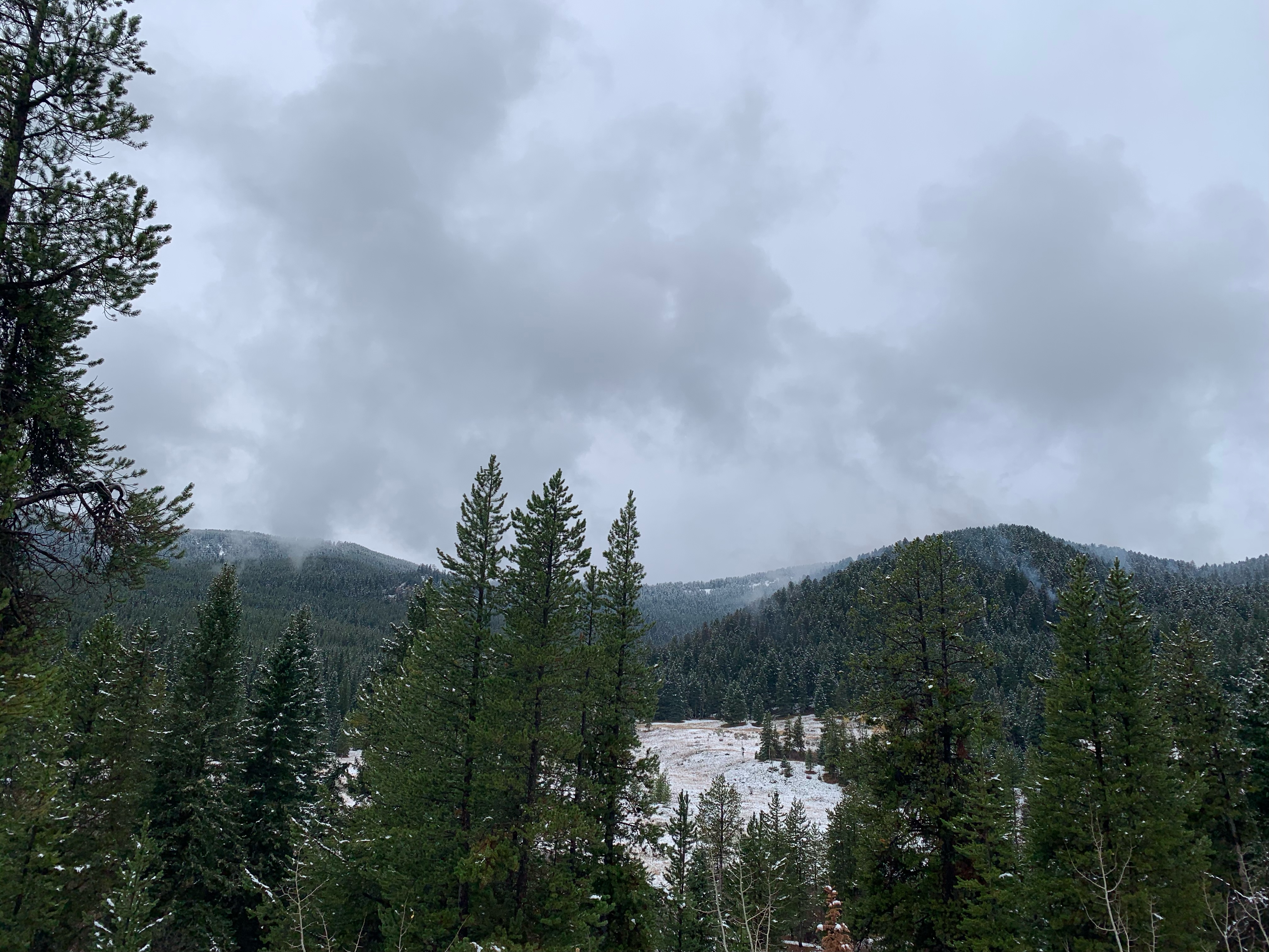
The lightning-sparked Moss Mountain Fire, which is adjacent to the Diamond Peak Wilderness, is approximately 2,724 acres in size and 10% contained. It was reported July 18, 2024, following a lightning event that caused multiple wildfires across the region.
Recreation sites that are now open include Bingham Boat Ramp, Middle Fork Trailhead (Sand Prairie), Middle Fork Trailhead (FSR-2127), Middle Fork Trailhead (Coal Creek), and Staley Ridge/Dome Rock Trailhead.
Recreation sites that have been removed from the closure order but that are CLOSED for the season include Sand Prairie Campground, Secret Campground, Camper’s Flat Campground, Sacandaga Campground, and Youngs Flat/Everage Flats Campground.
Trails and trailheads that remain closed include Corrigan Lake #3654, Bear Mountain Trailhead #3602, Blue Lake Trailhead #3645, Diamond Peak Trailhead #3699, Pioneer Gulch Trailhead #3630, Pool Creek Trailhead #4228, Vivian Lake Trailhead #3662, and all other trails within the Diamond Peak Wilderness.
For a map of the Moss Mountain closure area and a complete list of recreation sites and roads included in the order, visit https://www.fs.usda.gov/alerts/willamette/alerts-notices.
Please be aware of current restrictions before you head out into the forest and share information with others. As fire restrictions change, information will be available at https://www.fs.usda.gov/main/willamette/fire.
COMPLETED Prescribed Burn in Hyalite CanyonLangohr Road Area 10 18 2024
Related Incident: 2024 Custer Gallatin National Forest Prescribed Fire Program
Publication Type: News
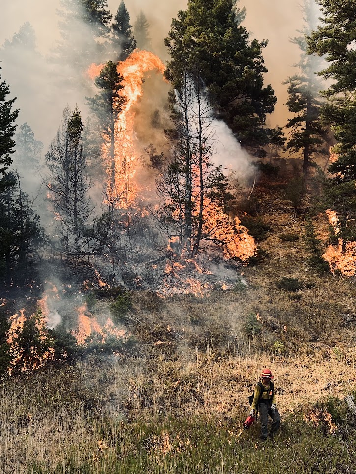
Bozeman, MT (Oct 18, 2024) – In Hyalite Canyon, fire managers HAVE COMPLETED prescribed burning on 116 acres within the Bozeman Municipal Watershed, BMW Unit 19, off the Langohr Road. This prescribed burn took place October15th and reduced fuel loads and lowered the risk of high severity wildland fires in the Bozeman Municipal Watershed.
Lingering smoke and flames may still be visible. Air quality is a key factor considered by land and fire managers during every phase of the prescribed fire and burning is only permitted when weather conditions are suitable for safe operations. Fire officials collaborate with the National Weather Service to ensure that the weather is favorable before, during, and after burning, as well as with the Montana Department of Environmental Quality to ensure smoke dispersal opportunities.
Hyalite Canyon traffic has only one way in and one way out. To ensure safety during operations, delays may occur as crews utilize Hyalite Canyon Road. Please exercise caution if traveling in the area as roadways may be impacted by smoke and fire traffic.
For additional information on these prescribed burns or how current closures could impact your visit to the forest, please visit us online at www.bznwatershed.com, on Facebook at Custer Gallatin National Forest, on Inciweb at 2024 Custer Gallatin National Forest Prescribed Fire Program or by calling the Bozeman Ranger District office at 406-522-2520. For additional information on the Forest Service Wildfire Crisis Strategy, please see Confronting the Wildfire Crisis | US Forest Service (usda.gov).
Elk Fire Evacuation Information 10 11 2024
Related Incident: Elk Fire 2024
Publication Type: Announcement
For the most up-to-date evacuation information, visit Sheridan County Emergency Management's news listings webpage.
DALYRAILROADFIRE ROADCLOSURE Bitterroot National Forest 10 11 2024
Related Incident:
Publication Type: Closures
U.S. Department of Agriculture, U.S. Forest Service
BITTERROOT National Forest Darby-Sula Ranger District
DALY-RAILROAD ROAD CLOSURE
PROHIBITIONS
Pursuant to 16 U.S.C. § 551 and 36 C.F.R. § 261.50 (b), the following is prohibited on the National Forest System (NFS) roads on the Darby-Sula Ranger Districts, Bitterroot National Forest, described below and shown on the attached map incorporated into this Order as Exhibit A (the “Described Roads):
Being on the road. 36 C.F.R. § 261.54(e).
EXEMPTIONS
Pursuant to 36 C.F.R. § 261.50(e), the following persons are exempt from this Order:
- Any Federal, State, or Local Officer, or member of an organized rescue or firefighting resource in the performance of an official duty.
- Persons with a Forest Service special use authorization or other authorization specifically exempting them from the effect of this Order.
DESCRIBED ROADS AND TRAILS
- Forest Service Road 711
- Forest Service Road 714
- Forest Service Road 1352
PURPOSE
The purpose of this Order is to ensure public health and safety during fire suppression efforts of the Daly-Railroad Fire.
IMPLEMENTATION
1. This Order shall be in effect from October 10th, 2024, at 0600 until rescinded or until December 1st, 2024, at 0001, whichever occurs first.
A map identifying the Described Roads is attached and made part of this Order as Exhibit A. For a digital version of this Order and Exhibit A, go to Bitterroot National Forest - Alerts &Closures (usda.gov)
Unless otherwise expressly defined in this Order, the terms used in this Order are defined by the regulations of the Secretary of Agriculture, 36 C.F.R. Chapter II, Parts 200-299. If there are terms in this Order that are not expressly defined in the Order or 36 C.F.R. Chapter II, Parts 200-299, their meaning shall be determined by their plain language definitions.
A violation of the above prohibitions is punishable as a Class B misdemeanor by a fine of not more than $5,000 for individuals and $10,000 for organizations, or by imprisonment for not more than six months, or both. 16 U.S.C. § 551; 18 U.S.C.
§§ 3559, 3571, and 3581.
Contact the Darby-Sula Ranger District in Darby, MT, (406) 821-3913, or Bitterroot National Forest Supervisor’s Office in Hamilton, MT, (406) 363-7100, for more information about this Order.
This Order supersedes any previous Orders prohibiting the same or similar acts in/on the same Described Roads.
Done at Hamilton, Montana this 10th day of October 2024.
Bachelor Complex Update 10 11 2024
Related Incident: Bachelor Complex Fires
Publication Type: News
Bachelor Complex Update October 11, 2024
There was minimal fire activity on the 14,529-acre Little Lava Fire yesterday and it remains 63% contained. Firefighters took advantage of cooler temperatures and cloud cover to continue securing and establishing control lines.
Yesterday, firefighters worked to extinguish sources of heat 100 feet in along the fire’s edge on the northeastern flank. Crews identified and mopped up a small spot fire east of the slopover across Forest Service Road (FSR) 45 near FSR 4188 that had been smoldering since the increased fire activity on Tuesday. Resources continued reducing fuels along FSR 45 on the eastern flank and FSR 4525 and FSR 4529 on the western flank to prepare the roads as control lines ahead of the fire.
Limiting fire progression to the east remains the priority today. Mop-up operations along the northeastern flank of the fire will continue to secure control lines. Firefighters are also gridding to the north and east ahead of the fire to look for any additional smoldering spot fires that might be lingering from the increased fire activity on Tuesday.
Crews and heavy equipment will continue constructing a shaded fuel break as needed along FSR 45 to reduce fuels and prepare the road as an eastern control line. Air resources are available to help the crews that are working to keep the northeastern corner of the fire in check while a control line is established along FSR 45. Resources are also assessing safe and effective opportunities to engage the fire more directly on the northeastern edge.
Cooler temperatures are expected over the next couple days which will aid suppression efforts.
The Deschutes National Forest updated and increased the temporary emergency fire closure area for the Bachelor Complex yesterday. The closure area was expanded east to include the area west of FSR 4180 north to Cascade Lakes Highway. The expansion was due to continued fire activity on the Little Lava Fire as hot and dry conditions persist and incursions into the prior closure area. A map of the updated closure area and the order can be viewed here: https://www.fs.usda.gov/alerts/deschutes/alerts-notices.
For current wildfire information, the public can visit centraloregonfire.org or follow fire information on X (Twitter) @CentralORFire.
Bachelor Complex Update 10 09 2024
Related Incident: Bachelor Complex Fires
Publication Type: News
Bachelor Complex Update October 9, 2024
The Little Lava Fire was very active yesterday due to dry fuel conditions and gusty winds. Currently, the fire is estimated to be 14,529 acres and remains 63% contained.
Weather conditions were favorable today and firefighters made great progress. Dozer line was constructed around the roughly 100-acre slopover that became established east of Forest Service Road (FSR) 45 yesterday near FSR 4188. Just south of the slopover, crews used tactical burning operations along the west side of FSR 45 to remove a pocket of unburned fuel ahead of the main fire to secure this section of the road. Aircraft was very active throughout the day dropping water to limit fire growth and cool hot spots.
Additional resources arrived at the fire today including one hotshot crew, four engines, and three dozers. Additional resources have also been ordered.
Tomorrow, the priority will continue to be limiting fire progression to the east. Firefighters plan to install hose lays along the dozer line and begin mopping up the 100-acre slopover across FSR 45 near FSR 4188. Crews will continue reducing fuels along FSR 45 to prepare the road as an eastern control line. Resources will also continue to look for safe and effective opportunities to engage the fire more directly on the northeastern edge.
Tomorrow’s weather forecast will be favorable for fire suppression efforts. Temperatures are expected to be 60-65 degrees with light easterly winds.
An emergency fire area closure remains in place for the Bachelor Complex to provide for public and firefighter safety. Firefighters have recently encountered members of the public within the closure area which can hinder fire suppression efforts and is unsafe as the fire isn’t fully contained. A map of the current closure area and the order can be viewed here: https://www.fs.usda.gov/alerts/deschutes/alerts-notices
For current wildfire information, the public can visit centraloregonfire.org or follow fire information on X (Twitter) @CentralORFire.
# # #
Tiger Creek Fire Daily Update 10 11 2024
Related Incident: Tiger Creek Fire
Publication Type: News
Current Situation: Acreage has decreased to 532 acres with improved ground mapping on the Tiger Creek Fire and 19 percent containment has been achieved with 486 firefighting resources assigned. Full suppression of the fire remains the top priority of the crews operating on the fire.
Crews continued to mop up, monitor, and patrol the south edge of the fire and south end of the 65 road near Tiger Creek as it remains a concern to containment. Hose lays continue to be placed and several were rerouted for better water delivery to the fire line to ease mop-up activity, including the horseshoe area of the fire. Sawyer crews have completed the removal of fire weakened and hazard trees along the fire’s edge to enable safer working conditions for fire crews. Hand line has been completed all the way around the eastern spot fire with hose lays in place to assist in mop-up of the spot fire. A road crew will begin evaluating areas impacted by heavy fire equipment and traffic along the 65 road.
Closures and Restrictions: Access through Forest Service Road (FSR) 65 up through FSR 64 to the junction with Indian Camp is closed. Government Mountain Road/FSR 6511 is closed from North Fork Walla Walla trailhead to the junction with FSR 65 at Tiger Saddle. Government Mountain Rd/FSR 6511 is open from the west to North Fork Walla Walla trailhead. The current fire danger rating is MODERATE and public use restrictions phase A for Umatilla National Forest are in effect. For more information regarding restrictions, please contact Umatilla National Forest Toll-free Information Hotline: 1.877.958.9663.
Weather: Humidity recoveries overnight were moderate to excellent. A stronger inversion will be expected today and will lift late morning. Moderate cloud cover until midday will be present. Temperatures will be trending warmer. As cloud cover decreases over the day, winds are expected to increase but remain light. Today’s weather will see highs in the mid 50s to mid 60s and afternoon humidity will reach 35-45%. The winds will be westerly at 3-6 mph with a few higher gusts on the ridgelines. Tomorrow, expected weather will partly cloudy becoming clear in the afternoon with temperatures around 55-65 degrees.
Smoke: Walla Walla’s air quality for today is good to moderate, some residents along Mill Creek may experience smoke as the fire continues to burn. Check out https://wasmoke.blogspot.com/?m=1 for more information.
RailroadDaly Fire Update 10 11 2024
Related Incident:
Publication Type: News
Type 3 Incident Command Team, Incident Commander Matt Young
Location: Bitterroot NF: Railroad Creek/ Skalkaho Creek confluence, 26 miles southeast of Hamilton
Beaverhead-Deerlodge NF: 20 Miles northwest of Georgetown Lake Dam off Skalkaho Hwy 38
Start Date: 7/25/2024
Cause: Undetermined
Daly Fire Acres: 9,493 Railroad Fire Acres: 1,441 Completion: 56%
Total Personnel: 230
Current Status
With the cooler temperatures, the Railroad-Daly fire showed minor growth in acres yesterday. Fire crews utilized firing operations to burn ground fuels between control line and the fires flaming front from Gird Point Rd to Hwy 38. Helicopters aided firefighters during firing operations to cool down fires edge.
Today crews will assess the need to continue firing operations in the Gird Point area in efforts to establish an anchor point. Structure protection will continue between Gird Creek Road and Hwy 38. Firefighters will proceed with scouting for natural control features to aid with operations.
Weather and Fire Behavior
Today cloud cover is predicted to provide slightly cooler temperatures and slightly higher relative humidity. Wind is predicted to be between 6-9 mph with gusts of 20 mph in the afternoon.
Clouds and cooler temperatures will help to moderate fire behavior on existing wildfires. Smoke and haze will still be a concern, particularly over portions of Southwest Montana.
By midday Friday, the HRRR smoke model shows heavy smoke surging into Western Montana from regional wildfires. Conditions can change quickly as weather could stimulate active fires and the likelihood of new starts increases. Please keep track of concentrations at todaysair.mtdeq.us or the Fire and Smoke Map.
EVACUATIONS
On October 9, 2024 the Ravalli County Sheriff’s Office issued an Evacuation Warning for residents off of Skalkaho Highway (1700-2500 block) due to the Railroad-Daly Fire. For more information on evacuations visit the Ravalli County Sheriff Facebook page.
To register your phone number for emergency notifications in Ravalli County visit, http://hyper-reach.com/mtravallisignup.html.
CLOSURES
For additional information on the Skalkaho Hwy 38 road closure visit Montana Department of Transportation.
Beaverhead-Deerlodge National Forest has issued an Area/Road/Trail Closure (Closure #01020824-19) effective October 4, 2024. This Order is for public and firefighter safety during fire suppression efforts of the Fire. Closure information and maps are posted on the Bitterroot and Beaverhead-Deerlodge National Forests’ website www.fs.usda.gov/alerts/bdnf/alerts-notices and www.fs.usda.gov/alerts/bitterroot/alerts-notices.
Pack Trail Daily Update October 11 2024 10 11 2024
Related Incident:
Publication Type: News
Pack Trail Daily Update October 11, 2024
Total Acres: 68,956 Confined: 64%
Total Personnel: 571
Operations – Today, due to near – red flag conditions, there will be significant fire behavior. Yesterday, the Pack Trail Fire continued backing into the area of Cowboy Camp, Strawberry Warming Hut and Fish Creek Guard Station near Union Pass Road where firefighters continue to clean up hotspots, patrol and refill tanks for the sprinklers. Crews continue to address hotspots and monitor the fire, which is holding north of Union Pass Road. On the west flank, firefighters continue to patrol the Burnt Ridge area, where fire continues to slowly creep downhill. Structure crews continue to wrap buildings, install hose lays and sprinklers at Elk Track Ranch and in the Gros Ventre area. On the east side, there was active fire behavior overnight and is expected to continue today. Crews are conducting structure protection in the Highway 26 corridor. Yesterday, crews worked in the Union Pass Subdivision to reduce hazardous fuels around homes. On the north side, there was no new fire activity, but some heat remains in the interior and smoke may be visible. Crews continue to patrol the area checking for new smoke and growth.
Safety - Drivers on US-26 may experience periods of smoke today due to high winds. Please use caution while driving, use headlights, and expect to encounter fire vehicles along the road. If planning travel on US-26 across the Continental Divide monitor WY-DOT for possible closures due to fire activity.
Teton Interagency Fire managers are maintaining the Very High Fire Danger Rating for Grand Teton National Park, the Bridger-Teton National Forest, and the National Elk Refuge. Due to excessively dry fuels, any spark can ignite fire which can spread rapidly, becoming a large fire and exhibit extreme fire intensity. Residents and visitors are urged to exercise extreme caution with fire or possible ignition sources. Always build your campfires away from dry grass, leaves, and overhanging branches to reduce the risk of spreading wildfire. Clear at least a 10-foot perimeter around your fire, removing any flammable material, and make sure your fire is dead out and cool to touch before you go to sleep, or leave the area.
Weather – Today’s weather and unstable atmosphere brings potential for significant fire behavior. Today will be sunny with temperatures in the mid 60s. The wind will be from the West/Southwest at 12-16 MPH with gusts up to 27. Relative humidity is18-23%. To learn more about air quality, visit Fire.AirNow.Gov.
Road Closures – The Union Pass Road is closed on the Pinedale District (BTNF) from Mosquito Lake to the Moon Lake Road on the Wind River District (SHO).
Evacuations – The Upper Gros Ventre area (Goosewing and Elk Track Ranches) in Teton County have been put into a Level 2 “Set” Evacuation Warning. Evacuations and evacuation alerts for several subdivisions and ranches in Fremont County, WY remain in place. See the Fremont County Emergency Management Facebook Page for alerts and updates. See the Teton County Emergency Management website updates and to sign up for emergency alerts through Everbridge.
Forest Closures - Closure Order #04-03-24-316 is in effect from October 9, 2024 at 12:00 p.m. through November 1, 2024 at 6:00 a.m. unless rescinded. This order supersedes previous orders, including #04-03-24-315, prohibiting the same or similar acts in the same described area.
For more information, visit: Facebook: USDA Forest Service - Bridger-Teton National Forest, USDA Forest Service - Shoshone National Forest Pack Trail Inciweb: https://inciweb.wildfire.gov/incident-information/wybtf-pack-trail-fire
Rail Ridge Daily Update 10 11 2024
Related Incident:
Publication Type: Announcement
Rail Ridge Fire Update
October 11, 2024
Central Oregon Wildfire Information: centraloregonfire.org
Email: 2024.railridge@firenet.gov – Phone: 541-208-7111
Social Media, Evacuation and Closure Information: https://linktr.ee/RailRidgeFire
Acres: 174,081 – Containment: 89% – Detection: 09/02/24 – Cause: Lightning – Personnel: 620
Visitors looking to hunt or recreate on public lands over the holiday weekend should be aware that Forest and BLM closures around the Rail Ridge Fire remain in place. These closures are in place to protect members of the public from hazards such as damaged roads, hazard trees, burning stumpholes and unstable ground as well as fire crews and equipment working around the fire. Although the weather forecast is more favorable for fire suppression than it has been in several days, the area has not had any measurable precipitation and the potential for fire activity to increase remains a factor.
Operational Update: Yesterday, fire personnel continued the use of the Unmanned Aircraft System (UAS) with Plastic Sphere Dispensers (PSD) for aerial ignition operations to help build depth in the Black Canyon Wilderness. The UAS was also used to fly the smaller uncontained lines on the northern side of the fire, using IR to look for hot spots close to the fires edge. Moderated weather allowed crews to regain focus on the suppression repair of dozer lines, and removal of hazard trees within the fire area.
Today, we will see favorable weather conditions again which will allow fire personnel to continue to focus on suppression repairs and mopup, including removing hazardous trees and locating hot spots like stumpholes that are still smoldering. Minimum Impact Suppression Tactics (MIST) are being used to mopup and manage the fire in the Black Canyon Wilderness. On the northwest side of the fire due to the difficult to access terrain, firefighters will be utilizing roadways and natural barriers to create fire breaks as much as possible. The fire team and private landowners are working together to better assess the terrain and access points on the northern side of the uncontained fire area. Opportunities are being explored that would allow firefighters to minimize the growth of this active fire area on Cougar Ridge. Helicopters will be used today to assess helispots and put in radio repeater sites. Air resources will continue to be available to firefighters to utilize as needed to minimize fire spread and severity.
The fire team and local agencies continue to work with local landowners, businesses and affiliates who need access into the fire area closures. Due to the multitude of hazards within the fire area, these requests are being prioritized and official escorts are being provided as safety and availability of escorts are feasible.
Weather: Favorable fire weather conditions will continue today, however minimum RH values will be a bit drier during the peak heating hours this afternoon, in the 20-30% range. Winds will remain mostly terrain driven and fairly light, with gusts up to 10-12 mph possible in the late afternoon. High pressure will remain positioned over the area through the weekend and into the first half of next week, with dry conditions expected.
Forest & BLM Closures / Evacuation Information / Fire Restrictions for the Rail Ridge Fire area can be found at: https://linktr.ee/RailRidgeFire.