
Incident Publication
Bingham Fire Update for Thursday October 3 2024 10 03 2024
Related Incident: Bingham Fire
Publication Type: News
Marcel Potvin, Incident Commander
Start date: Sept. 30, 2024
Location: Detroit Ranger District,
Willamette National Forest
Cause: Undetermined
Fire size: 195 acres
Full Suppression
Personnel: 126, including 4 Crews, 10 Engines, 1 Dozer
The Bingham Fire, located east of the Bingham Ridge Trailhead near Marion Forks, was reported on the evening of Sept. 30, 2024. The fire is burning partially within an older fire scar along the Bingham Ridge Trail that extends into the Mount Jefferson Wilderness area.
LEVEL 3: GO NOW! Evacuation Alerts have been issued by the Linn County Sheriff’s Office for a large area of the Mount Jefferson Wilderness. Additionally, LEVEL 2: GET SET Evacuation Alerts have been issued for the area around Marion Forks Campground, and Marion Forks Fish Hatchery. The Level 2 evacuation area also extends along Highway 22, to ½-mile west of Highway 22, from Pamelia Road (NFS Road 2246) south to Parrish Lake Road (NFS Road 2266). Please refer to the Linn County Wildfire Map for more information: https://tinyurl.com/LinnCoFireMap. Highway 22 remains open at this time.
A large evacuation area like this is necessary to give wildfire response teams enough space to safely travel to and fight the fire, as crews will be on road systems, trails, and air assets may be utilizing nearby water sources. The fire itself is much smaller than the evacuation area. The Willamette National Forest will be issuing an updated formal closure later today in the same footprint of the Level 3 Evacuation. The Pacific Crest Trail will remain open.
Firefighters are working as direct as possible to the fire’s edge. In the last two days, 18 smokejumpers, 11 rappelers, 3 hand crews, 1 hot shot crew, 10 engines, 4 professional falling teams and 1 dozer have responded to the fire and are preparing primary fire line and opening access routes to the fire area. Possible secondary and contingency fire lines are being discussed and scouted in the next few days. Shared air resources including helicopters and airtankers were able to complete multiple retardant and water drops on the fire to successfully slow the rate of spread. Additional resources have been ordered to support the full suppression actions.
WEATHER: Yesterday, cooler weather and higher humidity levels moderated fire behavior. Light easterly winds are forecasted for the fire area through mid-day Friday, with possible temperatures reaching the lower to mid-70s with lower relative humidity on Thursday. On Friday afternoon, rain is forecasted in the area, with the potential for up to 0.25 inches of precipitation. Smoke may be visible from Detroit, Idanha, and along Highway 22 today.
SAFETY: Members of the public are encouraged to heed local evacuation orders issued by the county sheriff’s office and emergency notification systems. Know the Ready, Set, Go levels and make appropriate preparations. READY your belongings; SET your things at the door or prepack them in your car; GO and leave immediately.
Yellow Lake Fire Update 10 03 2024
Related Incident: Yellow Lake Fire
Publication Type: News
Oct 3,2024— Firefighters are working diligently on the Yellow Fork Fire, and it is now 6% contained. The current acreage is 2,560. Despite containment only slowly increasing, firefighters are making progress on the fire.
Crews continue to enhance the fuel break around the fire, using handline, bulldozer line, natural barriers, and thinning fuels. This indirect line is near completion along the gas pipeline corridor, as well as near the Mill Hollow area. Structure protection is near completion at the YMCA camp and the ranger station. Firefighters have been installing hoselay in these areas, both for suppression efforts now and mop up later. No structures or recreation property have been damaged.
Crews are strategically firing along the indirect line to decrease unburned fuel along firebreaks between the current fire perimeter. This methodical approach has been successful, reducing the timeframe to reach containment and open Highway 35. There is a predicted wind shift this weekend, where winds will be coming from the south instead of the north. These firing operations may continue to occur to enhance the fuelbreaks prior to the predicted wind shift and create a strong northern perimeter.
This fire remains a full suppression fire. Fire managers are working to reach containment safely. It’s important to understand that containment does not mean the fire has not grown. Containment indicates that fire managers are confident that it will not grow along that portion of the perimeter. In heavy fuels like timber that can retain heat for long periods of time, it is imperative that crews are methodical about assuring there are no heat sources that could reignite later and spot across the existing lines. Containment is expected to increase slowly as crews stop progression and reduce all heat sources that could threaten the lines.
Highway 35 remains closed for at least 24-48 hours, until fire activity decreases and the road can be cleared of debris.
The fire has been determined to be human caused, but it is still under investigation. More information will be released once the final investigation report is completed.
The Yellow Lake Fire is located east of Mill Hollow Reservoir on the Uinta-Wasatch-Cache National Forest, with 384 personnel assigned to the incident.
.jpg?VersionId=Yf9vLaBzaR6mmCNFB24CFM3ub0FoYfpu)
Rail Ridge Fire Update 10 03 2024
Related Incident:
Publication Type: News
Rail Ridge Fire Update
October 03, 2024
Central Oregon Wildfire Information: centraloregonfire.org
Email: 2024.railridge@firenet.gov – Phone: 541-208-7111
Social Media, Evacuation and Closure Information: https://linktr.ee/RailRidgeFire
Acres: 167,718 – Containment: 89% – Detection: 09/02/24 – Cause: Lightning – Personnel: 795
Northwest Complex Incident Management Team 8, lead by Incident Commander Brian Ebert took command of the Rail Ridge Fire this morning at 6:00am. Thank You to Alaska Complex Incident Management Team #3 for your time, dedication and hard work on the Rail Ridge Fire.
Operational Update
Yesterday, calmer winds across the fire area led to subdued fire growth. The additional acreage burned was on the west/northwest area of the fire in the Black Canyon Wilderness in Honeymoon Creek. The tactical burning accomplished previously on the southern edge of the wilderness is still holding as a strong containment feature. Around the other contained areas of the fire, firefighters continued mop-up, patrol and suppression repair. The northern edge of the fire still has areas of fire perimeter which remain uncontained due to inaccessible terrain. Firefighters will continue to monitor these areas and work toward containment as they can safely engage.
Today, the fire team will continue to assess the fire activity in the wilderness and have management action points in place and are prepared to act on as the fire progresses. Firefighters continue construct contingency control lines and strengthen containment in the Black Canyon Wilderness, adding depth to lines that are already in place. Fire activity today is expected to be similar to yesterday. Even with the cooler night temperatures, the critically dry fuels will continue to burn and smoke will be visible across the fire footprint. The contained areas of the fire will continue to be patrolled, mopped up and suppression repairs are ongoing with resource advisors.
Weather
A cold start in the morning hours today will lead to similar temperatures as yesterday in the low 70’s. Winds will be light today and mostly terrain-driven across the fire area. Dry conditions will persist with stronger winds from the southwest on Friday.
Evacuations
Level 1 evacuations in Grant County were dropped yesterday and the level 2 evacuations remain. Wheeler County evacuation remain the same.
For Current Evacuation Levels all affected counties, please visit: https://linktr.ee/RailRidgeFire
Closures: The U.S. Forest Service and Bureau of Land Management have implemented closures for the Rail Ridge Fire. For more details and closure maps, visit https://linktr.ee/RailRidgeFire
Bingham Fire Update Wednesday October 2 2024 10 02 2024
Related Incident: Bingham Fire
Publication Type: News
Detroit Ranger District - Located 1.5 miles east of the Bingham Ridge Trailhead in the Mount Jefferson Wilderness east of Marion Forks. The fire is approximately 181 acres according to an infrared detection flight. The fire cause is undetermined. Resources on scene include hand crews, engine crews, dozers, smoke jumpers, rappelers, and aerial resources.
The Forest and Linn County Emergency Managers are working to determine necessary closures for firefighter and public safety. The public is asked to continue avoiding Forest Service Road (FSR) 2253 and the Bingham Ridge Trail #3421 to allow emergency responders and fire crews the space they need to work.
Visitors with permits that include Bingham Ridge Trailhead in the Central Cascades Wilderness Permit system will receive a notification of an upcoming emergency closure.
Public Meeting for Fish Creek and Pack Trail Fire Updates Scheduled For Friday 10 04 2024
Related Incident:
Publication Type: Announcement
A public meeting to discuss the current fire situation will be held Friday, October 4 at 6:00 p.m. The public meeting will be held at the National Museum of Military Vehicles at 6419 US Highway 26 in Dubois.
Line Fire Fact Sheet 10 03 2024
Related Incident: Line Fire
Publication Type: News
Yesterday, firefighters made great progress on the Line Fire overcoming high heat and steep terrain to keep the fire in its current footprint. Night flying helicopters are being utilized to extinguish heat both along the fire perimeter as well as extinguishing burning fuels in the interior. Today, crews will continue to monitor and patrol along the Highway 330 corridor on the western flank of the fire. Fire crews have been inserted to go direct along the fire’s edge with the assistance of water dropping helicopters along Siberia Creek. On the eastern flank of the fire, firefighters will continue to mop up, strengthen and improve containment lines.
A Community Meeting has been scheduled at the Big Bear Performing Arts Center at 1:00 p.m. on Saturday, October 5, 2024. The address is 39707 Big Bear Blvd, Big Bear Lake, CA. 92315.
HomesteadDiamond Complexes Daily Fire Update 10 03 2024
Related Incident: Lane 1 Fire
Publication Type: News
Homestead/Diamond Complexes Fire Update
Oct. 3, 2024
Fire Information: 541-208-7100, 8 AM - 8 PM
InciWeb-Homestead: https://t.ly/syeHa and InciWeb-Diamond: https://bit.ly/4gCfLsp
Six fires within the Homestead and Diamond Complexes remain under active management by Northwest Team 12. Firefighting resources from the Homestead/Diamond Complexes remain available for initial attack response to new fire starts in the area as needed.
The Oregon Department of Transportation temporarily lowered the speed limit on Hwy 138 in front of the Fire Incident Command Post just east of Glide to 45 MPH for the safety of firefighters and community residents.
Homestead Complex: 10,284 acres, 35% contained │ Diamond Complex: 11,141 acres, 90% contained │ Total personnel: 371
Although westerly winds brought slightly cooler and more humid conditions yesterday, fires continued to creep and back into very dry fuels. Today will return to unseasonably warm and very dry conditions, with a corresponding potential increase in fire activity.
A heavy helicopter dropped 27,900 gallons of water on the northwest corner of the Horse Heaven Fire yesterday to slow the fire from backing into the Horse Heaven Creek drainage. Mastication work is making progress on the north side of the fire area along Forest Service Road (FSR) 092 and an extensive grading operation continues along Forest Service FSR 3831. A few days of work chipping along interior roads remains for crews and heavy equipment to complete.
Fire activity on the Fuller Lake Fire remains at a low intensity, consuming surface fuels and an abundance of dead and downed trees in the Boulder Creek Wilderness. Fire managers continue to monitor the fire activity in the Wilderness to determine the need for additional action. Teams of sawyers continue to identify and mitigate hazard trees along FSR 5851 that have been weakened by the fire. Road work within the Bullpup Fire area is making good progress. Road repairs on FSR 3816 are ongoing, and repair work is nearing completion on FSRs 200 and 300.
The No Man Fire continues to be in a patrol and monitor state, with engine crews on the lookout for any smokes that may materialize.
Two fires remain uncontained on the Diamond Complex. On the Potter Fire, dump trucks finished hauling slash to the Diamond Lake area and chipping will resume today. Grading along FSR 3703 is underway and making steady progress. The Pine Bench Fire continues to show no visible smoke.
Closures: The Umpqua National Forest and the Bureau of Land Management (BLM) have revised closure orders. Two closure orders impact the Umpqua National Forest https://t.ly/Mvn6G. A BLM Roseburg District closure order remain also remains in place https://t.ly/uWX6l. A Temporary Flight Restriction remains in effect https://bit.ly/3XJL0cD.
Weather: High pressure today will result in warmer and drier conditions, with temperatures forecasted to be 75-82 degrees in the valleys. There will be a weather disturbance on Friday that will cool temperatures and bring some light precipitation to the region late in the day Friday.
Goosmus Fire Update 10032024 10 03 2024
Related Incident: Goosmus Fire
Publication Type: News
Yesterday, crews continued making progress identifying and falling hazard trees along local roads and the fire line. Crews have been working with Palm IR units on the eastern and western flanks, helping them to identify remaining smoldering material that could threaten containment and extinguishing them.
Today, interior pockets are continuing to consume material and overall fire behavior with visible smoke is reducing. Crews will continue to work inward up to 100 feet from the fireline to extinguish remaining smoldering materials. Palm IR units continue to work northward to identify smoldering pockets of material to help crews finalize containment. Rehabilitation of non-primary containment lines (dozer lines or hand lines that are not used to contain the fire) are being evaluated for equipment or crew needs for completion. The State Mobilize engine strike teams are demobilizing and returning to their home districts.
The fire investigation has determined that the cause of the fire was non-negligence, green tree striking a powerline near Highway 21, during the wind event on September 25th.
Prescribed Burns in Hyalite Canyon South of Bozeman and in the North Bridgers are Postponed 10 03 2024
Related Incident: 2024 Custer Gallatin National Forest Prescribed Fire Program
Publication Type: Announcement
Bozeman Ranger District fire managers are postponing ignitions on planned burns in Hyalite Canyon near Langohr campground, south of Bozeman, Montana. As well as planned burns in the South Brackett Creek and Fairy Lake areas of the North Bridgers. Associated closures for the burn areas are lifted.
Fire managers remain in constant coordination with weather forecasters and smoke specialists leading up to and during a prescribed burn.
At this time, forecasted weather conditions (specifically potential high winds and low relative humidity) are no longer providing favorable conditions to conduct prescribed fire operations. Although conditions could be favorable today, conditions don’t appear favorable into Friday and over the weekend which could lead to challenges with holding and mop up operations.
The Bozeman Ranger District will continue to look for favorable burning conditions in the near future and new notifications will occur at that time.
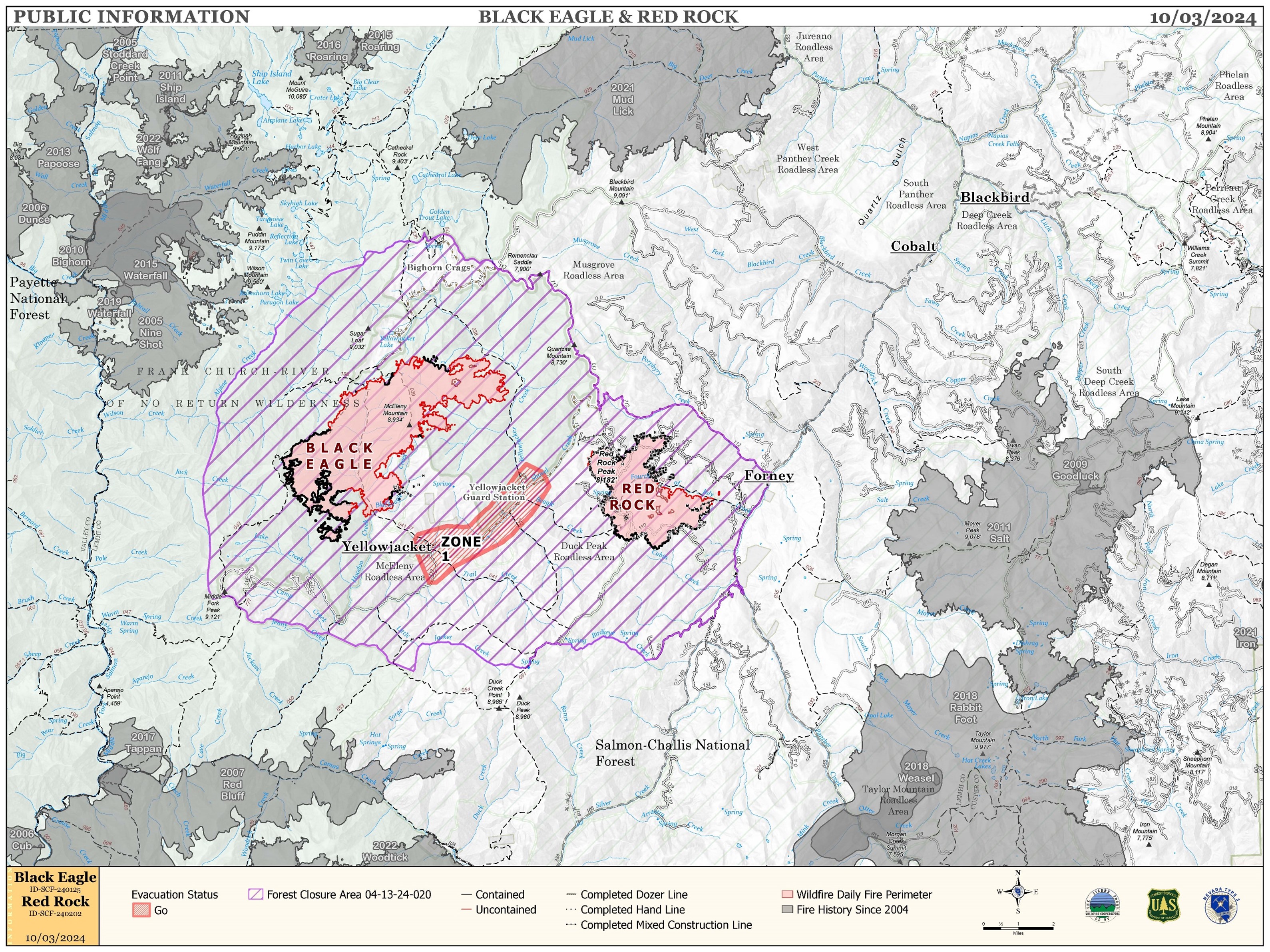
Red Rock and Black Eagle Fire Daily Update 10 03 2024
Related Incident:
Publication Type: News
FIRE ACTIVITY:
The Red Rock Fire is at 3,615 acres and 78% containment.
Over the last few days the Red Rock Fire added about 250 acres, primarily on the northeast side of the fire in the Fourth of July Creek area. Firefighters are conducting burnout operations there to bring the fire safely down to the creek. Poor overnight humidity recovery and westerly winds gusting over 20 mph allowed for alignment of fuels in east-west drainages in the interior of the fire as well. On the north, south, and west sides of the fire, where containment has been established, crews are monitoring fire activity and beginning suppression repair work.
The Black Eagle Fire is at 7,935 acres and 16% containment.
The Black Eagle Fire added about 500 acres over the last few days, primarily in designated wilderness on the north side of the fire. The west to east drainages remain in alignment with westerly winds and activity was observed in Blackeagle Creek as well as the drainages above Yellowjacket Creek. Use of aircraft was needed to maintain control features.
WEATHER:
Weak high pressure over the fire area will bring light southwesterly winds and cooler temperatures today. Due to the cooler morning temperatures, the morning humidity recovery will be higher than the past few evenings, but the afternoon humidity will again dip into the lower teens. Today’s forecast high for the fire area is 60 with southwest winds only reaching about seven mph with gusts to 16 mph. A more powerful system will move into the Pacific Northwest Friday, bringing strong winds but continued dry conditions.
FIRE BEHAVIOR:
Nearly all fuels are available across both fires, though heavy dead and down fuels remain most problematic for firefighters. Areas where humidities fall below 25% with gusty afternoon winds can experience increased activity, including short-range spotting. Opportunities to attack the fire directly will likely be confined to morning hours and when effective water support is available.
FOREST CLOSURES: For forest closure information please go to: https://www.fs.usda.gov/alerts/scnf/alerts-notices
EVACUATIONS: For evacuation information in Lemhi County regarding these fires please go to: Emergency Management Department | Lemhi County, ID (lemhicountyidaho.org).