
Dolan Fire Evening Update August 30 2020
Related Incident:
Publication Type: News
Incident Information:
Start / Report Date: Aug. 18, 2020 Cause: Unknown
Fuels Involved: Chaparral, Brush, Timber understory
Size: 27,936
Location: Hwy 1(MM32.20) N of Limekiln State Park, 10 miles S of Big Sur
Containment: 25%
Injuries: 0
Total Personnel: 1,025
Resources:
Hand Crews: 16
Engines: 77
Dozers: 9
Helicopters: 10
Water Tenders: 25
Current Situation:
Today there was a smoke inversion over the fire and a morning marine inversion on the west side. These inversions contributed to reduced fire behavior on all perimeters.
Crews made progress on the north edge of the fire along McWay Ridge and are cautiously optimistic that they will be able to hold the fire to that ridge. Work is still required in the area to manage the fire activity and the unburned vegetation that remains at risk of igniting. The east perimeter progressed today, traveling further into the Ventana Wilderness.
The eastern half of the south side is actively burning on Twin Peak Ridge, above Limekiln State Park. Crews are planning to keep working on the containment line which will parallel the fire’s southern trajectory to protect the communities of Hermitage and Lucia. The western half of the south side is now contained. Crews will patrol the contained line and firefighters are confident that it is looking good.
Highway 1 has a section that is still burning on the east side of the highway in very steep terrain. Crews are monitoring the area to prevent the fire from spreading to the west side of the road, but given the rugged terrain, they are unable to get close to the burn. Large debris continues to roll onto, and across, the freeway. Patrols are watching for hazardous rolling material and removing it from the road.
The fire poses a risk to multiple businesses, parks, recreational sites, and communication infrastructure as well as the communities of Hermitage and Lucia in the south, and Partington Ridge in the north. Among natural resources threatened are the Ventana Wilderness, coastal watershed, and habitat for threatened and endangered species, including the California condor.
Fire activity in the western United States has caused a high demand for fire personnel and equipment. The nation is at the highest level, Preparedness Level 5 (PL5). In PL5 over 80% of the nation’s incident management teams and wildland firefighting personnel are committed to incidents. Currently, there are 73 large uncontained fires nationwide. Fires have burned over 3.9 million acres with over 1.2 million acres burned in California alone. Resource orders are being prioritized to fires across the west. Acreage reported here is an estimate and will be updated when IR images are available.
Carmel Fire Info: https://www.fire.ca.gov/incidents/2020/8/18/carmel-fire/
River Fire Info: https://www.fire.ca.gov/incidents/2020/8/16/river-fire/
Updates and Meetings: Fire Information is producing two daily written updates. To request an update, email 2020.dolan@firenet.gov and provide your email address.
There was a virtual community meeting today at 2 PM. The meeting was live-streamed on the Los Padres National Forest Facebook page can be viewed retroactively.
Weather: A marine inversion is forecasted to develop in the early morning to around 1200 feet deep and it will cover the west flank of the fire. Otherwise, clear and smoky skies are in the forecast. Weather conditions will be monitored closely to adapt and execute an appropriate plan.
Evacuations / Closures: Click here for an interactive map of Monterey County evacuations. For information about state highway closures go to https://roads.dot.ca.gov/.
Nacimiento-Fergusson Road is closed to all traffic (public and residential) from Highway 1 to the Fort Hunter Liggett base boundary line 16 miles inland. This closure includes the intersection with South Coast Ridge Road at Nacimiento-Fergusson Road summit. Los Burros Road, Plaskett Road and South Coast Ridge Road are closed to all but residential traffic.
Smoke: The air quality in communities around the fire are forecasted to range from Good to Unhealthy for Sensitive Groups (USG). Smoke and haze will likely be visible, especially in the afternoon when the marine layer lifts. Smoke intensity will continue to depend on the activity of the Dolan, River and Carmel fires.
A!ert Monterey County: To receive emergency notifications regarding evacuations and critical events in Monterey County please sign up for A!ert Monterey County at the following website: https://member.everbridge.net/453003085611217/login.
Cooperating and Assisting Organizations: National Weather Service, California Highway Patrol, Monterey County Sheriff’s Department, Big Sur Volunteers, Cal Trans, California State Parks, OES, Ventana Wilderness Alliance
Dolan Fire Morning Update August 30 2020
Related Incident:
Publication Type: News
Incident Information:
Start / Report Date: Aug. 18, 2020
Cause: Unknown
Location: Hwy 1(MM32.20) N of Limekiln State Park, 10 miles S of Big Sur
Fuels Involved: Chaparral, Brush, Timber understory
Size: 25,587
Containment: 25%
Injuries: 0
Resources:
Hand Crews: 17
Engines: 89
Dozers: 10
Helicopters: 8
Water Tenders: 29
Total Personnel: 1,055
Current Situation:
Last night firefighters continued to work in the steep terrain along McWay Ridge to establish fireline. Patches and lines of unburnt vegetation remain, and crews are keeping a close eye on fire activity. Crews are making good progress and are cautiously optimistic, but the containment lines will be tested by hot and dry weather that is forecasted to come in this afternoon and over the next few days. Air operations will be used when visibility allows, typically in the afternoons.
Good progress was made on the containment line around Hermitage last overnight. Firefighters continue to assess the fire behavior and plan for the southeast line in the Twin Peak and Cone Peak area. Crews will work along Nacimiento-Fergusson Road to prepare the road as a potential fireline.
Crews made progress along Highway 1 overnight and will continue work to fully contain the perimeter along the highway. The road remains closed because of the risk of the fire spreading to the west side and falling debris. The fire could ignite on the west side due to rolling materials or if the fire travels down underpasses and drainages. The east perimeter progressed today, traveling further into the Ventana Wilderness.
The fire poses a risk to multiple businesses, parks, recreational sites, and communication infrastructure as well as the communities of Hermitage and Lucia in the south, and Partington Ridge in the north. Among natural resources threatened are the Ventana Wilderness, coastal watershed, and habitat for threatened and endangered species, including the California condor.
Fire activity in the western United States has caused a high demand for fire personnel and equipment. The nation is at the highest level, Preparedness Level 5 (PL5). In PL5 over 80% of the nation’s incident management teams and wildland firefighting personnel are committed to incidents. Currently, there are 73 large uncontained fires nationwide. Fires have burned over 3.9 million acres with over 1.2 million acres burned in California alone. Resource orders are being prioritized to fires across the west. Acreage reported here is an estimate and will be updated when IR images are available.
Carmel Fire Info: https://www.fire.ca.gov/incidents/2020/8/18/carmel-fire/
River Fire Info: https://www.fire.ca.gov/incidents/2020/8/16/river-fire/
Updates and Meetings: Fire Information is producing two daily written updates. To request an update, email 2020.dolan@firenet.gov and provide your email address.
There will be a virtual community meeting today at 2 PM. The meeting will be live-streamed on the Los Padres National Forest Facebook page can be viewed live or retroactively.
Weather: The marine inversion is around 1500 feet deep and covers the west flank of the fire. It is expected to lift midmorning. Otherwise, clear and smoky skies are in the forecast for the east side and for the afternoon in the west. Weather conditions will be monitored closely to adapt and execute an appropriate plan.
Evacuations / Closures: Click here for an interactive map of Monterey County evacuations. For information about state highway closures go to https://roads.dot.ca.gov/.
Nacimiento-Fergusson Road is closed to all traffic (public and residential) from Highway 1 to the Fort Hunter Liggett base boundary line 16 miles inland. This closure includes the intersection with South Coast Ridge Road at Nacimiento-Fergusson Road summit. Los Burros Road, Plaskett Road and South Coast Ridge Road are closed to all but residential traffic.
Smoke: The air quality in communities around the fire are forecasted to range from Good to Unhealthy for Sensitive Groups (USG). Smoke and haze will likely be visible, especially in the afternoon when the marine layer lifts. Smoke intensity will continue to depend on the activity of the Dolan, River and Carmel fires.
A!ert Monterey County: To receive emergency notifications regarding evacuations and critical events in Monterey County please sign up for A!ert Monterey County at the following website: https://member.everbridge.net/453003085611217/login.
Cooperating and Assisting Organizations: National Weather Service, California Highway Patrol, Monterey County Sheriff’s Department, Big Sur Volunteers, Cal Trans, California State Parks, OES, Ventana Wilderness Alliance.
Safety Message: This will be a long duration event. Residents in the affected area are encouraged to continue to prepare for the possibility of fire in their area in advance. Go to https://www.ready.gov/wildfires to learn how to prepare.
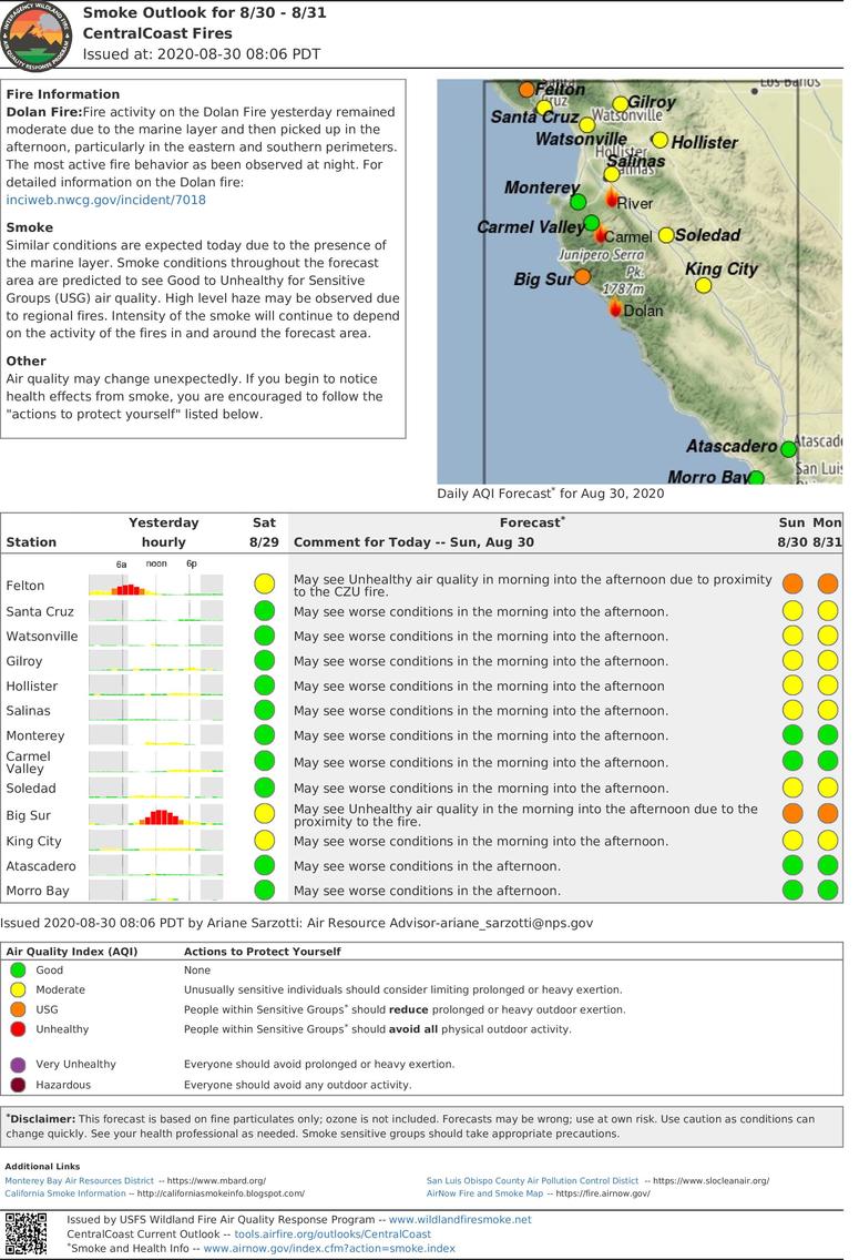
Central Coast Fires Smoke Outlook for 830 831
Related Incident:
Publication Type: News
Issued at: 2020-08-30 08:06 PDT
Fire Information
Dolan Fire: Fire activity on the Dolan Fire yesterday remained moderate due to the marine layer and then picked up in the afternoon, particularly in the eastern and southern perimeters. The most active fire behavior as been observed at night. For detailed information on the Dolan fire: inciweb.nwcg.gov/incident/7018
Smoke
Similar conditions are expected today due to the presence of the marine layer. Smoke conditions throughout the forecast area are predicted to see Good to Unhealthy for Sensitive Groups (USG) air quality. High level haze may be observed due to regional fires. Intensity of the smoke will continue to depend on the activity of the fires in and around the forecast area.
Other
Air quality may change unexpectedly. If you begin to notice health effects from smoke, you are encouraged to follow the "actions to protect yourself" listed below.
Dolan Fire Evening Update August 29 2020
Related Incident:
Publication Type: News
Incident Information:
Start / Report Date: Aug. 18, 2020
Cause: Unknown
Location: Hwy 1(MM32.20) N of Limekiln State Park, 10 miles S of Big Sur
Fuels Involved: Chaparral, Brush, Timber understory
Size: 25,587
Containment: 25%
Injuries: 0
Resources:
Hand Crews: 17
Engines: 89
Dozers: 10
Helicopters: 8
Water Tenders: 29
Total Personnel: 1,055
Current Situation:
In the north, along McWay Ridge, firefighters made good headway connecting open lines from the top and the bottom in very steep terrain. Some patches and lines of unburnt vegetation remain and threaten the containment line. Crews will keep a close eye on fire activity and work on the area throughout the night. The east perimeter progressed today, traveling further into the Ventana Wilderness.
In the southeast, the fire began to move down Twin Peak Ridge. Crews are working to keep that area in check and are evaluating how to best contain that edge. Firefighters are working on a line southeast of Cone Peak to stop the fire as it advances. They continue to monitor the fire behavior around Twin and Cone Peaks and will attack direct if the opportunity presents itself. They have also scouted Nacimiento-Fergusson Road and will begin tomorrow to prepare the road as a potential fireline.
Crews will patrol Highway 1 overnight and work to contain the perimeter along the highway. The fire still threatens to burn towards the west side of the highway via drainages and underpasses. Rolling materials pose a risk to roll onto or over the highway to the west side and could spark flames.
Fire activity along the western edge will likely subside early in the early morning as the marine layer comes in. The east perimeter is expected to travel east overnight. The fire on the north side is predicted to become more active tonight and crews are working hard in the area to maintain the perimeter.
The fire poses a risk to multiple businesses, parks, recreational sites, and communication infrastructure as well as the communities of Hermitage and Lucia in the south, and Partington Ridge in the north. Among natural resources threatened are the Ventana Wilderness, coastal watershed, and habitat for threatened and endangered species, including the California condor.
Fire activity in the western United States has caused a high demand for fire personnel and equipment. The nation is at the highest level, Preparedness Level 5 (PL5). In PL5 over 80% of the nation’s incident management teams and wildland firefighting personnel are committed to incidents. Currently, there are 77 large uncontained fires nationwide. Fires have burned over 3.9 million acres with over 1.2 million acres burned in California alone. Resource orders are being prioritized to fires across the west. Acreage reported here is an estimate and will be updated when IR images are available.
Carmel Fire Info: https://www.fire.ca.gov/incidents/2020/8/18/carmel-fire/
River Fire Info: https://www.fire.ca.gov/incidents/2020/8/16/river-fire/
Updates and Meetings: Fire Information is producing two daily written updates. To request an update, email 2020.dolan@firenet.gov and provide your email address.
There will be a virtual community meeting tomorrow at 2 PM. The meeting will be live-streamed on the Los Padres National Forest Facebook page and can be viewed live or retroactively.
Weather: The marine inversion is around 1500 feet deep and covers the west flank of the fire. It is expected to lift midmorning. Otherwise, clear and smoky skies are in the forecast for the east side and for the afternoon in the west. Weather conditions will be monitored closely to adapt and execute an appropriate plan.
Evacuations / Closures: Click here for an interactive map of Monterey County evacuations. For information about state highway closures go to https://roads.dot.ca.gov/.
Nacimiento-Fergusson Road is closed to all traffic (public and residential) from Highway 1 to the Fort Hunter Liggett base boundary line 16 miles inland. This closure includes the intersection with South Coast Ridge Road at Nacimiento-Fergusson Road summit. Los Burros Road, Plaskett Road and South Coast Ridge Road are closed to all but residential traffic.
Smoke: The Monterey Bay Air Resources District has issued a Wildfire Air Quality Advisory. When the concentration of smoke has reached UNHEALTHY levels of the AQI, residents should limit their activity by staying indoors with the doors and windows closed to avoid breathing smoke. Updates on the current air quality forecast and Air Monitoring data can be found at http://air.mbard.org/.
A!ert Monterey County: To receive emergency notifications regarding evacuations and critical events in Monterey County please sign up for A!ert Monterey County at the following website: https://member.everbridge.net/453003085611217/login.
Cooperating and Assisting Organizations: National Weather Service, California Highway Patrol, Monterey County Sheriff’s Department, Big Sur Volunteers, Cal Trans, California State Parks, OES, Ventana Wilderness Alliance.
Safety Message: This will be a long duration event. Residents in the affected area are encouraged to continue to prepare for the possibility of fire in their area in advance. Go to https://www.ready.gov/wildfires to learn how to prepare.
Pronstico de Humo para 2908 3008
Related Incident:
Publication Type: News
Actualizado: 2020-08-29 12:09 PDT
Aviso Especial
Para obtener información detallada sobre los avisos locales de calidad del aire, consulte los enlaces mas adelante. Hay una advertencia de Bandera Roja por ráfagas de viento y relámpagos secos en efecto hasta las 5:00 pm de hoy.
Incéndios
Fuego CZU: https://www.fire.ca.gov/incidents/2020/8/16/czulightning-complex-including-warnella-fire/
Fuego River:
https://www.fire.ca.gov/incidents/2020/8/16/river-fire/
Fuego Carmel:
https://www.fire.ca.gov/incidents/2020/8/18/carmel-fire/
Fuego Dolan: https://inciweb.nwcg.gov/incident/7018/
Humo
Hoy se esperan condiciones similares a las de ayer debido a la presencia de la capa marina. Se pronostica que las condiciones de humo en toda el área de pronóstico muestren una calidad de aire de Buena a Insalubre. La intensidad del humo seguirá dependiendo de la actividad de los incendios dentro y alrededor del área de pronóstico.
Más
La calidad del aire puede cambiar inesperadamente. Si comienza a notar los efectos del humo en la salud, le recomendamos que siga las "acciones para protegerse" en los enlaces a continuación.
Dolan Fire Road Closures
Related Incident:
Publication Type: Closures
Closures: For information about state highway closures go to https://roads.dot.ca.gov/.
Nacimiento-Fergusson Road is closed to all traffic (public and residential) from Highway 1 to the Fort Hunter Liggett base boundary line 16 miles inland. This closure includes the intersection with South Coast Ridge Road at Nacimiento-Fergusson Road summit. Los Burros Road, Plaskett Road and South Coast Ridge Road are closed to all but residential traffic.
This information is subject to change and is current at of 9 a.m. on Monday, August 31.
Dolan Fire Morning Update August 29 2020
Related Incident:
Publication Type: News
Incident Information:
Start / Report Date: Aug. 18, 2020
Cause: Unknown
Fuels Involved: Chaparral, Brush, Timber understory
Location: Hwy 1(MM32.20) N of Limekiln State Park, 10 miles S of Big Sur
Size: 25,587
Containment: 20%
Injuries: 0
Resources:
Hand Crews: 16
Engines: 84
Dozers: 10
Helicopters: 8
Water Tenders: 31
Total Personnel: 1,019
Current Situation:
Crews have made good progress along the north, west, and south perimeters and the fire activity in those sections was relatively calm overnight. Good progress was made along McWay Ridge, including along the spot that had escaped the perimeter yesterday, and crews are cautiously optimistic that the line will hold.
The fire held around the Twin Peak area on the southeast edge. Firefighters continue to assess Cone Peak and will be analyzing the fire behavior to determine how they will attack the fire on that southeast edge. The east perimeter grew overnight and progressed over Lost Valley Creek.
Crews will patrol Highway 1 and work to contain more of the perimeter along the highway. The fire still threatens to burn towards the west side of the highway via drainages and underpasses. Rolling materials also pose a risk to roll onto or over the highway to the west side and could spark flames. Patrolling and working the fire along the highway remains a priority. The other priority is to protect the local communities in the north and south and crews will be actively working in those areas.
Fire activity will pick up around midmorning when the marine layer lifts. Smoke and fire impacts may be visible, especially in the afternoon. Expect the east perimeter of the fire to move east throughout the day.
The fire poses a risk to multiple businesses, parks, recreational sites, and communication infrastructure as well as the communities of Hermitage and Lucia in the south, and Partington Ridge in the north. Among natural resources threatened are the Ventana Wilderness, coastal watershed, and habitat for threatened and endangered species, including the California condor.
Fire activity in the western United States has caused a high demand for fire personnel and equipment. The nation is at the highest level, Preparedness Level 5 (PL5). In PL5 over 80% of the nation’s incident management teams and wildland firefighting personnel are committed to incidents. Currently, there are 77 large uncontained fires nationwide. Fires have burned over 3.9 million acres with over 1.2 million acres burned in California alone. Resource orders are being prioritized to fires across the west. Acreage reported here is an estimate and will be updated when IR images are available.
Carmel Fire Info: https://www.fire.ca.gov/incidents/2020/8/18/carmel-fire/
River Fire Info: https://www.fire.ca.gov/incidents/2020/8/16/river-fire/
Updates and Meetings: Fire Information is producing two daily written updates. To request an update, email 2020.dolan@firenet.gov and provide your email address.
Weather: The marine inversion is around 1200 feet deep and covers the west flank of the fire. It is expected to lift midmorning. Otherwise, clear and smoky skies are in the forecast for the east side and for the afternoon in the west. Weather conditions will be monitored closely to adapt and execute an appropriate plan.
Evacuations / Closures: Click here for an interactive map of Monterey County evacuations. For information about state highway closures go to https://roads.dot.ca.gov/. Nacimiento-Fergusson Road is closed to all traffic (public and residential) from Highway 1 to the Fort Hunter Liggett base boundary line 16 miles inland. This closure includes the intersection with South Coast Ridge Road at Nacimiento-Fergusson Road summit.
Smoke: The Monterey Bay Air Resources District has issued a Wildfire Air Quality Advisory. When the concentration of smoke has reached UNHEALTHY levels of the AQI, residents should limit their activity by staying indoors with the doors and windows closed to avoid breathing smoke. Updates on the current air quality forecast and Air Monitoring data can be found at http://air.mbard.org/.
A!ert Monterey County: To receive emergency notifications regarding evacuations and critical events in Monterey County please sign up for A!ert Monterey County at the following website: https://member.everbridge.net/453003085611217/login.
Cooperating and Assisting Organizations: National Weather Service, California Highway Patrol, Monterey County Sheriff’s Department, Big Sur Volunteers, Cal Trans, California State Parks, OES, Ventana Wilderness Alliance.
Safety Message: This will be a long duration event. Residents in the affected area are encouraged to continue to prepare for the possibility of fire in their area in advance. Go to https://www.ready.gov/wildfires to learn how to prepare.
CentralCoast Fires Smoke Outlook for August 29 and 30
Related Incident:
Publication Type: News
Issued at: 2020-08-29 08:37 PDT
Fire Information
CZU:https://www.fire.ca.gov/incidents/2020/8/16/czu-lightningcomplex-including-warnella-fire/
River:https://www.fire.ca.gov/incidents/2020/8/16/river-fire/
Carmel:https://www.fire.ca.gov/incidents/2020/8/18/carmelfire
Dolan:https://inciweb.nwcg.gov/incident/7018
Smoke
Similar conditions are expected today due to the presence of the marine layer. Smoke conditions throughout the forecast area are predicted to see Good to Unhealthy air quality. Intensity of the smoke will continue to depend on the activity of the fires in and around the forecast area.
Other
Air quality may change unexpectedly. If you begin to notice health effects from smoke, you are encouraged to follow the "actions to protect yourself" listed below.
Dolan Fire Evening Update August 28 2020
Related Incident:
Publication Type: News
Incident Information:
Start / Report Date: Aug. 18, 2020 Cause: Unknown
Fuels Involved: Chaparral, Brush, Timber understory
Size: 24,860
Location: Hwy 1(MM32.20) N of Limekiln State Park, 10 miles S of Big Sur
Containment: 20%
Injuries: 0
Total Personnel: 1,019
Resources:
Hand Crews: 16
Engines: 84
Dozers: 10
Helicopters: 8
Water Tenders: 31
Current Situation:
Today the fire was very active on the north side, picking up around 10 AM. Crews worked hard to maintain the northern fire perimeter along McWay Ridge despite the active fire behavior. There is a spot along this Ridge where the fire escaped the perimeter by a few meters and firefighters are working to clean up that area and pull the fire back.
In the southeast, firefighters are assessing how to best engage the fire around Cone Peak. If the fire behavior is low and slow, then crews can engage directly along the fireline and potentially cut it off before Cone Peak. If fire behavior is active and aggressive, then firefighters will pull back create a new line to the southeast of Cone Peak.
The east side of the fire progressed and continues to grow as crews prioritize the north and the south sides of the fire to protect local communities in the north and south. The west side of the fire along Highway 1 is the next highest priority. Long stretches of the fire east of the highway have been contained, but some sections are persisting to smolder, burn, and deploy rolling material over the highway. Crews will be patrolling Highway 1 overnight to prevent the fire from crossing via rolling material or by burning down drainages and underpasses.
Overnight the fire is expected to be active until early in the morning, slowing down before dawn, and then picking back up as the marine layer lifts around 10 AM.
There is a new road closure at Nacimiento-Fergusson Road, which is closed to all traffic (public and residential) from Highway 1 to the Fort Hunter Liggett base boundary line 16 miles inland. This closure includes the intersection with South Coast Ridge Road at Nacimiento-Fergusson Road summit. All other road closures remain in place.
The fire continues to pose a risk to multiple businesses, parks, recreational sites, and communication infrastructure as well as the communities of Hermitage and Lucia in the south, and Partington Ridge in the north. Among natural resources threatened are the Ventana Wilderness, coastal watershed, and habitat for threatened and endangered species, including the California condor.
Fire activity in the western United States has caused a high demand for fire personnel and equipment. The nation is at the highest level, Preparedness Level 5 (PL5). In PL5 over 80% of the nation’s incident management teams and wildland firefighting personnel are committed to incidents. Currently, there are 82 large uncontained fires nationwide. Fires have burned over 3.8 million acres with over 1.1 million acres burned in California alone. Resource orders are being prioritized to fires across the west. Acreage reported here is an estimate and will be updated when IR images are available.
Carmel Fire Info: https://www.fire.ca.gov/incidents/2020/8/18/carmel-fire/
River Fire Info: https://www.fire.ca.gov/incidents/2020/8/16/river-fire/
Updates and Meetings: Fire Information is producing two daily written updates. To request an update, email 2020.dolan@firenet.gov and provide your email address. There was a community meeting today at 2 PM. The meeting was live-streamed on the Los Padres National Forest Facebook page can be viewed retroactively.
Weather: The marine inversion will develop overnight to around 1200 feet deep and will create morning low clouds and fog across the west flank of the fire. Clear and smoky skies are expected for the afternoon in the west. The eastern perimeter burns in drier and warmer conditions. Weather conditions will be monitored closely to adapt and execute an appropriate plan.
Evacuations / Closures: Click here for an interactive map of Monterey County evacuations. For information about state highway closures go to https://roads.dot.ca.gov/. Los Burros Road, Plaskett Ridge Road, and South Coast Ridge Road are closed to all but residents.
Smoke: The Monterey Bay Air Resources District has issued a Wildfire Air Quality Advisory. When the concentration of smoke has reached UNHEALTHY levels of the AQI, residents should limit their activity by staying indoors with the doors and windows closed to avoid breathing smoke. Updates on the current air quality forecast and Air Monitoring data can be found at http://air.mbard.org/.
A!ert Monterey County: To receive emergency notifications regarding evacuations and critical events in Monterey County please sign up for A!ert Monterey County at the following website: https://member.everbridge.net/453003085611217/login.
Cooperating and Assisting Organizations: National Weather Service, California Highway Patrol, Monterey County Sheriff’s Department, Big Sur Volunteers, Cal Trans, California State Parks, OES, Ventana Wilderness Alliance
Safety Message: This will be a long duration event. Residents in the affected area are encouraged to continue to prepare for the possibility of fire in their area in advance. Go to https://www.ready.gov/wildfires to learn how to prepare.
Pronstico de Humo para 2808 2908
Related Incident:
Publication Type: News
Actualizado: 2020-08-28 11:08 PDT
Aviso Especial
Para obtener información detallada sobre los avisos locales de calidad del aire, consulte los enlaces mas adelante. Hay una advertencia de Bandera Roja por ráfagas de viento y relámpagos secos en efecto hasta las 5:00 pm de hoy.
Incéndios
Fuego CZU: https://www.fire.ca.gov/incidents/2020/8/16/czulightning-complex-includingwarnella-fire/
Fuego River:
https://www.fire.ca.gov/incidents/2020/8/16/river-fire/
Fuego Carmel:
https://www.fire.ca.gov/incidents/2020/8/18/carmel-fire/
Fuego Dolan: https://inciweb.nwcg.gov/incident/7018/
Humo
Ayer vimos un poco de mejoría en la calidad de aire con respecto al día anterior. Hoy se esperan condiciones similares debido a la presencia de la capa marina. Se pronostica una tendencia a condiciones calientes y secas durante los próximos días, y hasta la próxima semana. Se pronostica que las condiciones de humo en toda el área de pronóstico muestren una calidad de aire de buena a Muy Insalubre. La intensidad del humo seguirá dependiendo de la actividad de los incendios, dentro y alrededor del área de pronóstico.
Más
La calidad del aire puede cambiar inesperadamente. Si comienza a notar los efectos del humo en la salud, le recomendamos que siga las "acciones para protegerse" en los enlaces a continuación.