
RED FLAG WARNING in Effect for Monday and Tuesday
Related Incident:
Publication Type: Announcement
The National Weather Service has issued a Red Flag Warning for the area of the White River Fire on Monday, September 7th from 11 a.m. through Tuesday 11 p.m.
A dry cold front arrives tomorrow bringing extreme fire weather conditions across much of Oregon.
Multiple days of 100+ degree temperatures along with low humidity and sustained high, and sometimes erratic, winds have created conditions that are ideal for wildland fire combustion and rapid spread.
Firefighters have made tremendous progress on strengthening containment lines over the last few days. We are prepared for these lines to be tested throughout the day.
Mt Hood National Forest Fire Restrictions remain in effect: https://www.fs.usda.gov/Internet/FSE_DOCUMENTS/fseprd776420.pdf
What is fire suppression repair
Related Incident:
Publication Type: News
This is the time in the fire when you hear us talking about "suppression repair," but what is it?
Fire suppression repair is a series of immediate post-fire actions taken to repair damages and minimize potential soil erosion and impacts resulting from fire suppression activities.
This work usually begins before the fire is contained and before the demobilization of an Incident Management Team.
This work repairs the hand and dozer fire lines, roads, trails, staging areas, safety zones and drop points used during fire suppression effort.
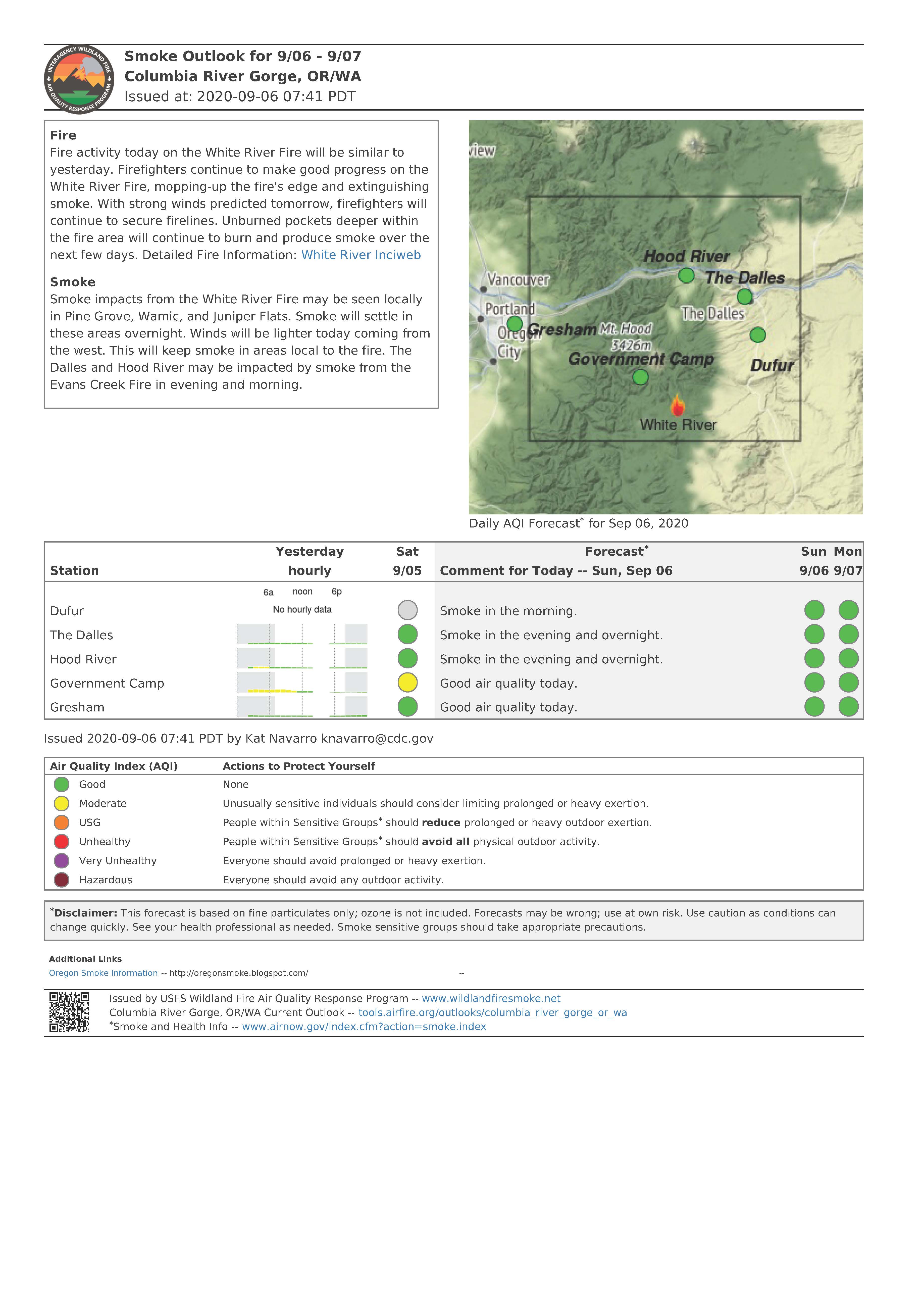
Smoke Outlook for Sunday September 6 2020
Related Incident:
Publication Type: News
Not much smoke expected from the White River Fire today. West and north winds should keep smoke from the Lionshead Fire out of our forecast area.
For a complete report visit: https://fires.airfire.org/outlooks/columbia_river_gorge_or_wa
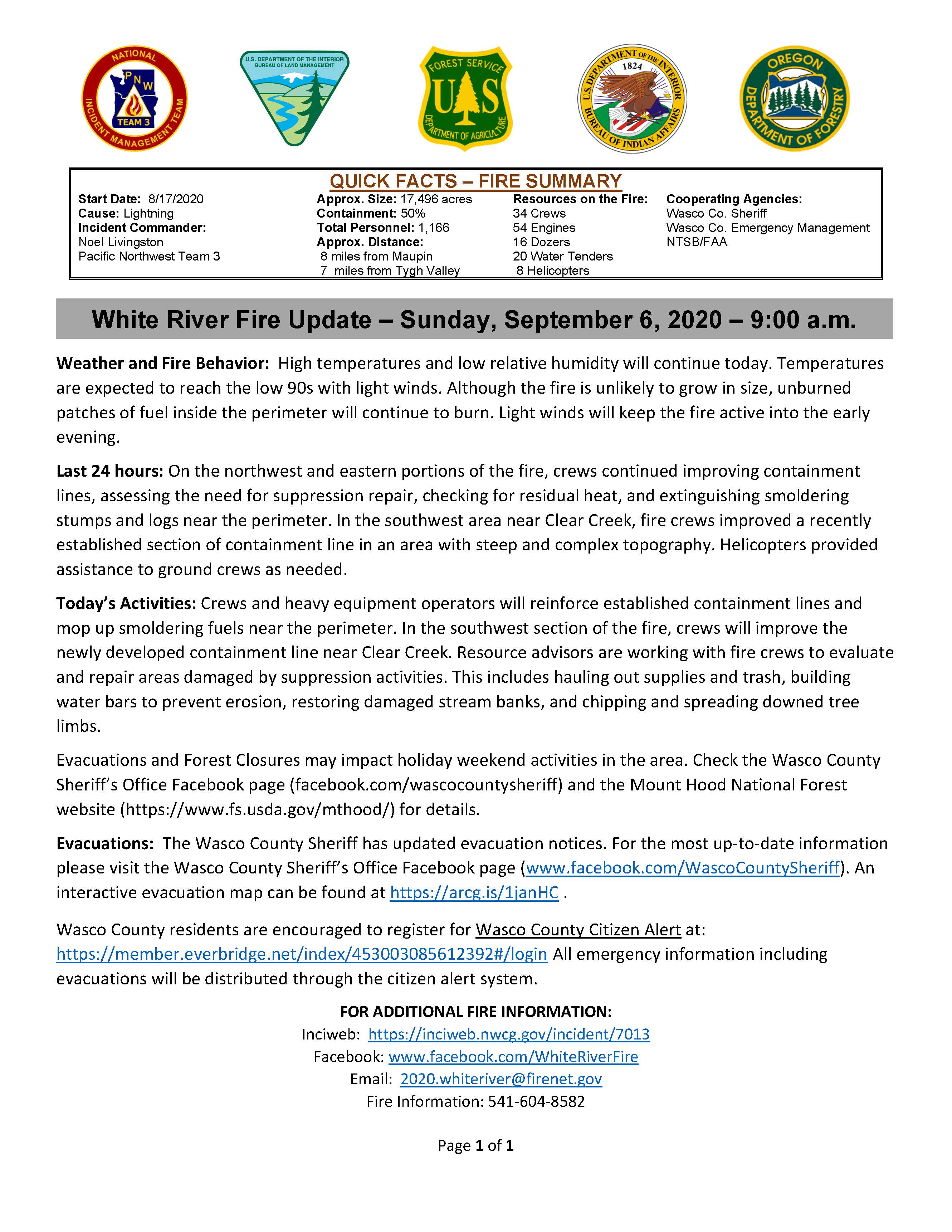
Daily Update for Sunday September 6 2020
Related Incident:
Publication Type: News
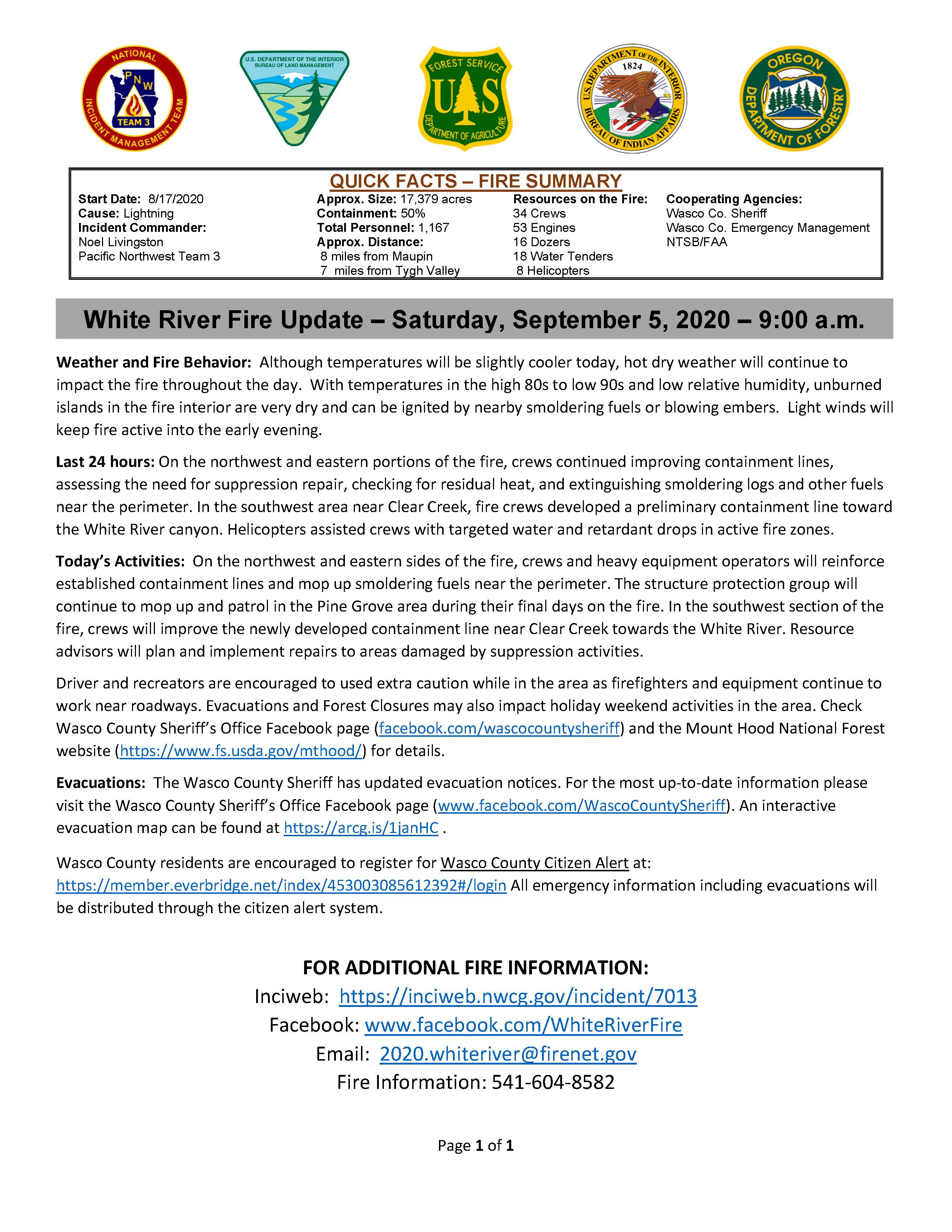
Quick Facts - Fire Summary
Start Date: 8/17/2020
Cause: Lightning
Incident Commander: Noel Livingston, Pacific Northwest Team 3
Approximate Size: 17,496 acres
Containment: 50%
Total Personnel: 1,166
Approximate Distance: 8 miles from Maupin/7 miles from Tygh Valley
Resources on the Fire:
34 crews
54 engines
16 dozers 20
water tenders
8 helicopters
Cooperating Agencies:
Wasco County Sheriff
Wasco County Emergency Management
NTSB/FAA
Weather and Fire Behavior: High temperatures and low relative humidity will continue today. Temperatures are expected to reach the low 90s with light winds. Although the fire is unlikely to grow in size, unburned patches of fuel inside the perimeter will continue to burn. Light winds will keep the fire active into the early evening.
Last 24 hours: On the northwest and eastern portions of the fire, crews continued improving containment lines, assessing the need for suppression repair, checking for residual heat, and extinguishing smoldering stumps and logs near the perimeter. In the southwest area near Clear Creek, fire crews improved a recently established section of containment line in an area with steep and complex topography. Helicopters provided assistance to ground crews as needed.
Today’s Activities: Crews and heavy equipment operators will reinforce established containment lines and mop up smoldering fuels near the perimeter. In the southwest section of the fire, crews will improve the newly developed containment line near Clear Creek. Resource advisors are working with fire crews to evaluate and repair areas damaged by suppression activities. This includes hauling out supplies and trash, building water bars to prevent erosion, restoring damaged stream banks, and chipping and spreading downed tree limbs.
Evacuations and Forest Closures may impact holiday weekend activities in the area. Check the Wasco County Sheriff’s Office Facebook page (facebook.com/wascocountysheriff) and the Mount Hood National Forest website (https://www.fs.usda.gov/mthood/) for details.
Evacuations: The Wasco County Sheriff has updated evacuation notices. For the most up-to-date information please visit the Wasco County Sheriff’s Office Facebook page (www.facebook.com/WascoCountySheriff). An interactive evacuation map can be found at https://arcg.is/1janHC .
Wasco County residents are encouraged to register for Wasco County Citizen Alert at: https://member.everbridge.net/index/453003085612392#/login All emergency information including evacuations will be distributed through the citizen alert system.
FOR ADDITIONAL FIRE INFORMATION:
Inciweb: https://inciweb.nwcg.gov/incident/7013
Facebook: www.facebook.com/WhiteRiverFire
Email: 2020.whiteriver@firenet.gov
Fire Information: 541-604-8582
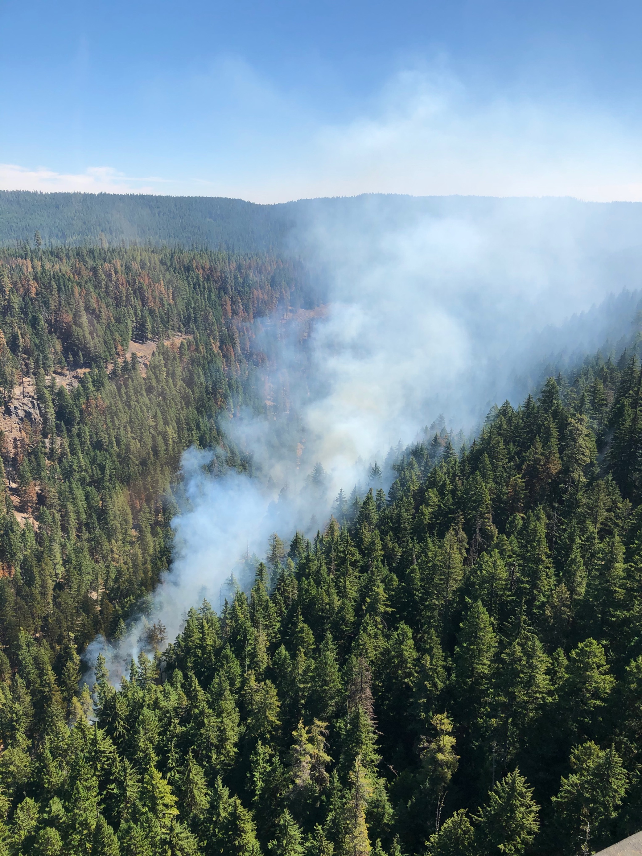
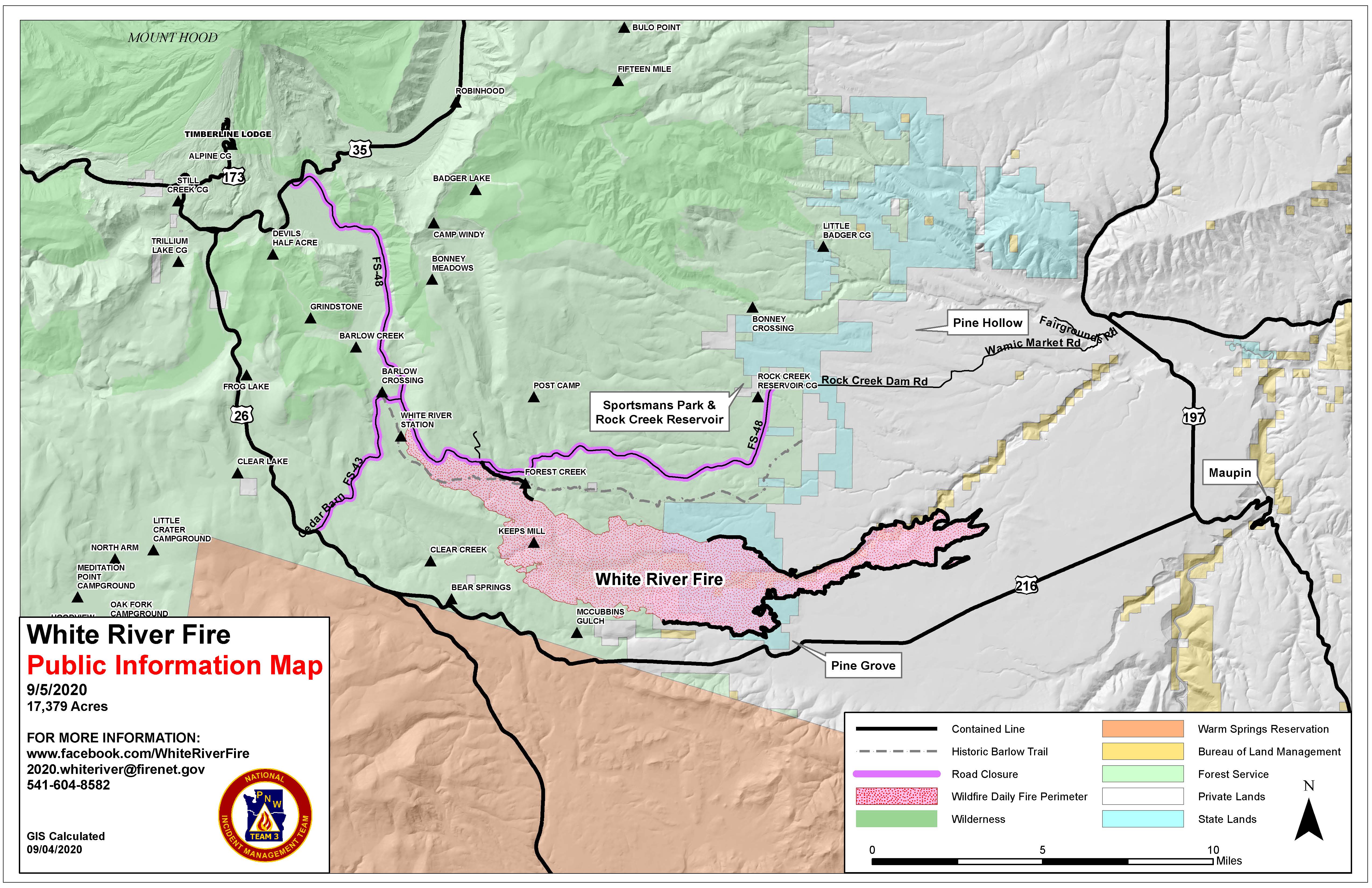
Burn Out Operation In Process Near Clear Creek
Related Incident:
Publication Type: Announcement
Firefighters are in the process of a burn out operation to improve the southwest portion of the fire line near Clear Creek. This technique reinforces the fire perimeter by removing vegetation between the containment line and the fire's edge. #WhiteRiverFire
3 Mile and Dodson Road Residents Expect Increased Fire Traffic
Related Incident:
Publication Type: Announcement
Special Safety Alert:
Residents on 3 Mile Road and Dodson Road in Wamic may see increased fire traffic today, Saturday, September 5th through Sunday, September 6th.Fire traffic will be diverted around Wamic to avoid congestion from this weekend’s Sportsman’s Grass Car Races. Best of luck to the racers!
Smoke Outlook for Saturday September 5 2020
Related Incident:
Publication Type: News
Yesterday smoke in the area was coming from Lionshead Fire, but NW winds today on that fire should keep our skies clear. For a complete report visit: https://fires.airfire.org/outlooks/columbia_river_gorge_or_wa
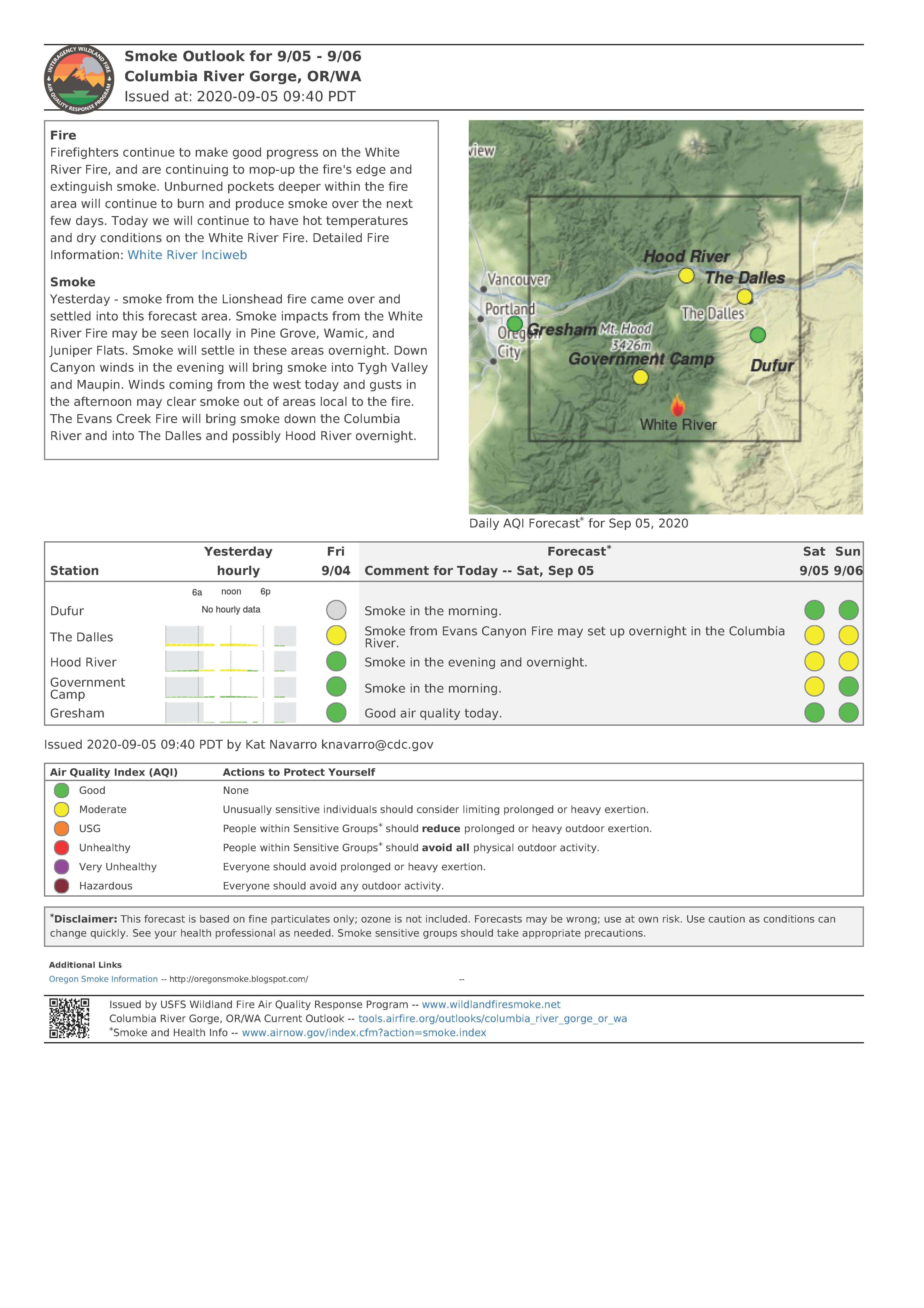
Daily Update for Saturday September 5 2020
Related Incident:
Publication Type: News
Quick Facts - Fire Summary
Start Date: 8/17/2020
Cause: Lightning
Incident Commander: Noel Livingston, Pacific Northwest Team 3
Approximate Size: 17,379 acres
Containment: 50%
Total Personnel: 1,167
Approximate Distance: 8 miles from Maupin/7 miles from Tygh Valley
Resources on the Fire:
34 crews
53 engines
16 dozers
18 water tenders
8 helicopters
Cooperating Agencies:
Wasco County Sheriff
Wasco County Emergency Management
NTSB/FAA
Weather and Fire Behavior: Although temperatures will be slightly cooler today, hot dry weather will continue to impact the fire throughout the day. With temperatures in the high 80s to low 90s and low relative humidity, unburned islands in the fire interior are very dry and can be ignited by nearby smoldering fuels or blowing embers. Light winds will keep fire active into the early evening.
Last 24 hours: On the northwest and eastern portions of the fire, crews continued improving containment lines, assessing the need for suppression repair, checking for residual heat, and extinguishing smoldering logs and other fuels near the perimeter. In the southwest area near Clear Creek, fire crews developed a preliminary containment line toward the White River canyon. Helicopters assisted crews with targeted water and retardant drops in active fire zones.
Today’s Activities: On the northwest and eastern sides of the fire, crews and heavy equipment operators will reinforce established containment lines and mop up smoldering fuels near the perimeter. The structure protection group will continue to mop up and patrol in the Pine Grove area during their final days on the fire. In the southwest section of the fire, crews will improve the newly developed containment line near Clear Creek towards the White River. Resource advisors will plan and implement repairs to areas damaged by suppression activities.
Driver and recreators are encouraged to used extra caution while in the area as firefighters and equipment continue to work near roadways. Evacuations and Forest Closures may also impact holiday weekend activities in the area. Check Wasco County Sheriff’s Office Facebook page (facebook.com/wascocountysheriff) and the Mount Hood National Forest website (https://www.fs.usda.gov/mthood/) for details.
Evacuations: The Wasco County Sheriff has updated evacuation notices. For the most up-to-date information please visit the Wasco County Sheriff’s Office Facebook page (www.facebook.com/WascoCountySheriff). An interactive evacuation map can be found at https://arcg.is/1janHC .
Wasco County residents are encouraged to register for Wasco County Citizen Alert at: https://member.everbridge.net/index/453003085612392#/login All emergency information including evacuations will be distributed through the citizen alert system.
FOR ADDITIONAL FIRE INFORMATION:
Inciweb: https://inciweb.nwcg.gov/incident/7013
Facebook: www.facebook.com/WhiteRiverFire
Email: 2020.whiteriver@firenet.gov
Fire Information: 541-604-8582
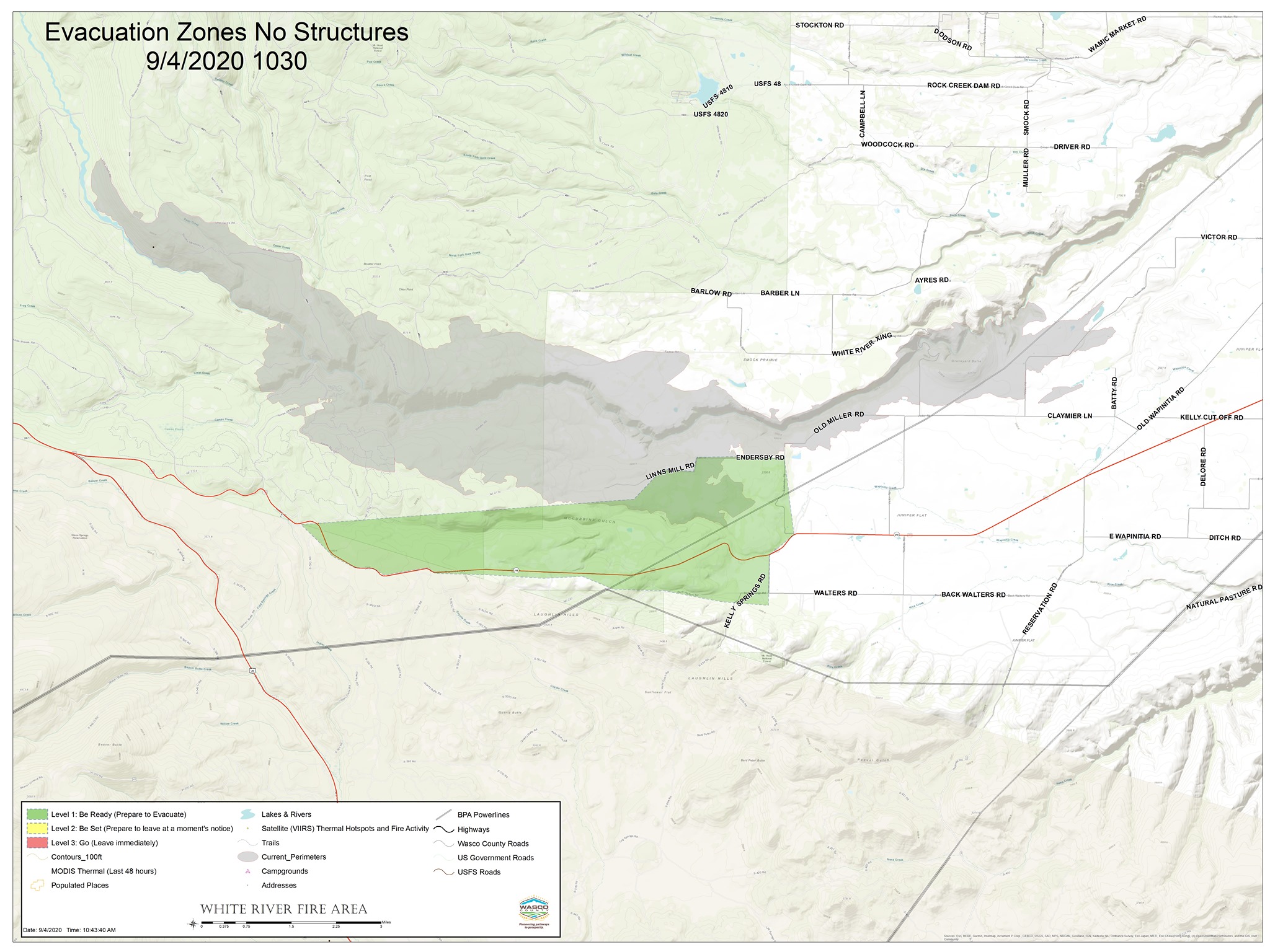
Wasco County Sheriffs Office Lifts Evaucation Levels Pine Grove Level 1
Related Incident:
Publication Type: Announcement
White River Fire Update 31Contact:Sheridan, McClellan, Wasco County Emergency Manager sheridanm@co.wasco.or.us White River Fire Update - Evacuation orders have changed as of Friday, September 4th, 2020. The firefighting teams have made excellent progress these last couple days in containing the fire, containment of the fire is now at 41% and 17,349 acres.Evacuation Levels have been lifted for Smock Rd, Sportsman's Park and Juniper Flat. Pine Grove has been lowered to Level 1 Get Ready.Level 1 GET READY for Pine Grove from the area east from Bear Springs Ranger Station along Hwy 216 through Pine Grove to the intersection of Endersby Rd and 216, also included are all of Endersby Rd, Linns Mill Rd and Kelly Springs Rd has been lowered to Level 1 GET READY.Evacuation Notice for all residences east side of Endersby Rd and East Side of Kelly Springs Rd to Hwy 197 has been lifted. Evacuation Notice for the area from Woodcock Rd to Driver Rd to White River Crossing to include Muller Rd, Smock Rd, Ayres Rd, Barber Lane and Barlow Rd has been lifted. The Evacuation Notice for Sportsman’s Park has been lifted.Below is information taken directly from the Pacific Northwest Team 3 Press release.Last 24 hours: On the northwest side of the fire, crews continued improving containment lines, assessing the need for rehabilitation, and extinguishing smoldering logs and other fuels near the perimeter. On the eastern half of the fire on both the north and south sides of the perimeter, crews patrolled containment lines, making improvements and checking for residual heat under junipers. In the southwest area near Clear Creek, fire crews scouted and planned for building containment line toward the White River canyon. Helicopters assisted crews with targeted water and retardant drops in active fire zones. Today’s Activities: On the northwest and eastern sides of the fire, crews and heavy equipment operators will reinforce established containment lines, mop up smoldering fuels near the perimeter, and plan for rehabilitating areas impacted by suppression efforts. The structure protection group will continue to mop up and patrol in the Pine Grove area. In the southwest section of the fire, crews will scout for and develop containment line in steep and complex terrain near the White River.Please continue to stay out of the area to allow crews to continue work. For more information about the White River Fire, contact Wasco County Emergency Management at 541-989-0200 or visit the Wasco County Sheriff’s Office Facebook page.