
North Complex Evening Update September 10 2020
Related Incident:
Publication Type: News
Current Situation
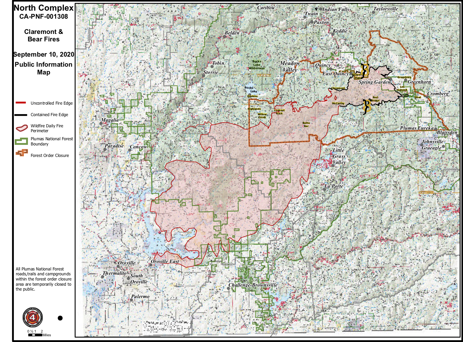
North Zone: From Lee Summit to Claremont Peak, the fire remains in the current footprint. Crews are engaged with tactical firing operations near Lookout Rock and reinforcing structure protection in the Bucks Lake, Haskins, and Highlands areas. Crews are prepping existing roads and building dozer lines to tie in with old fire scars and contingency lines from the Camp Fire. This will eventually tie in with Highway 70 north of Elephant Butte.
Evacuations and Road Closures
Butte County Sheriff’s Office: https://www.facebook.com/bcsonews
Plumas County Sheriff’s Office: https://www.facebook.com/plumascountysheriff
Yuba County Sheriff’s Office: https://www.facebook.com/yubacountysheriff
Planning Meeting daily at 7 P.M.: https://usfs.zoomgov.com/j/1600484186
North Complex Fire AM Update 09102020
Related Incident:
Publication Type: News
Current Situation
Evacuations and Road Closures
Butte County Sheriff’s Office: https://www.facebook.com/bcsonews
Plumas County Sheriff’s Office: https://www.facebook.com/plumascountysheriff
Yuba County Sheriff’s Office: https://www.facebook.com/yubacountysheriff
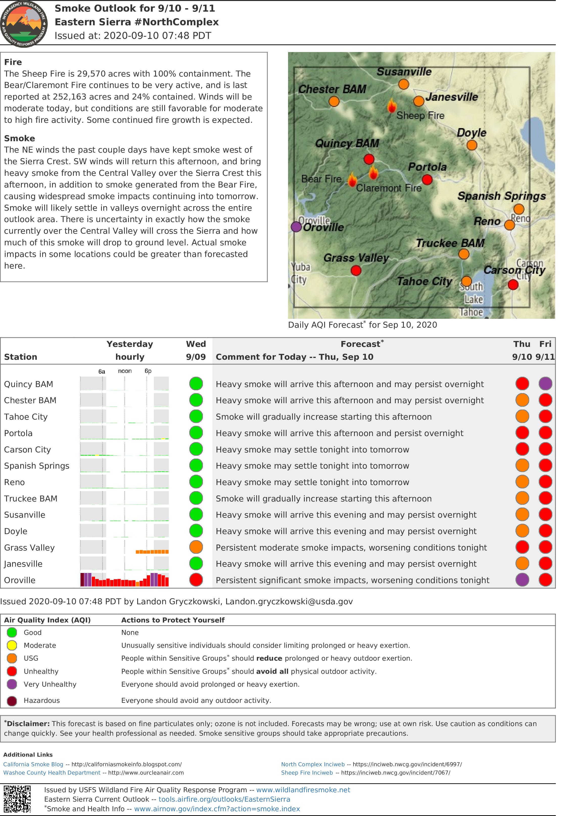
Typical southwest breezes will return this afternoon with warm and dry conditions. A smoke inversion is likely to increase smoky conditions. For specific smoke impacts to your area, visit www.airnow.gov.
Forest Closures
https://www.fs.usda.gov/Internet/FSE_DOCUMENTS/fseprd801413.pdf
Planning Meeting daily at 7 P.M.: https://usfs.zoomgov.com/j/1600484186
Smoke Outlook for 09102020
Related Incident:
Publication Type: News
The Sheep Fire is 29,570 acres with 100% containment. The
Smoke
The NE winds the past couple days have kept smoke west of
US Forest Closure Order 992020
Related Incident:
Publication Type: Closures
CA National Forests Temporary Closure (includes Plumas NF)
VALLEJO, Calif., September 9, 2020 – Due to unprecedented and historic fire conditions throughout the state, the USDA Forest Service Pacific Southwest Region is announcing a temporary closure of an additional ten National Forests, meaning all eighteen National Forests in California are now closed. The closure of the additional ten forests will be effective at 5:00 pm today. These additional forests include the Eldorado National Forest, Klamath National Forest, Lassen National Forest, Mendocino National Forest, Modoc National Forest, Six Rivers National Forest, Plumas National Forest, Shasta-Trinity National Forest, Tahoe National Forest, and Lake Tahoe Basin Management Unit. This decision will be re-evaluated daily as conditions change.
We had closed eight National Forests on Monday evening, Sept. 7, 2020. Explosive growth of fires throughout California during the day and late evening of Sept. 8th led to this updated decision.
“The number of large fires and extreme fire behavior we are seeing across the State is historic," said Regional Forester Randy Moore. "These temporary closures are necessary to protect the public and our firefighters, and we will keep them in place until conditions improve and we are confident that National Forest visitors can recreate safely. I ask all Californians and visitors to take these closures and evacuations seriously for their own safety and to allow our firefighters to focus on the mission of safely suppressing these fires."
The Forest Service thanks our partners and the public for their cooperation and understanding of this monumental fire threat. It is critical that all Californians and national forest visitors follow these important closures and restrictions for their own safety and the safety of our firefighters. Citizens with specific questions within their area amy call their local forests for more information.
The Forest Service manages 18 National Forests in the Pacific Southwest Region, which encompasses over 20 million acres across California, and assists forest landowners in California, Hawaii and the U.S. Affiliated Pacific Islands. National forests supply 50 percent of the water in California and form the watershed of most major aqueducts and more than 2,400 reservoirs throughout the state. For more information, visit www.fs.usda.gov/R5.
North Complex Evening Update September 9 2020
Related Incident:
Publication Type: News
Current Situation
Butte County Sheriff’s Office: https://www.facebook.com/bcsonews
Plumas County Sheriff’s Office: https://www.facebook.com/plumascountysheriff
Yuba County Sheriff’s Office: https://www.facebook.com/yubacountysheriff
Weather and Air Quality
Winds tapered off this afternoon and shifted east. The next few days will see a shift in winds to a southwest flow more typical of this time of year. Warm and dry conditions are expected to continue. For specific smoke impacts to your area, visit www.airnow.gov.
Forest Closures
Due to unprecedented and historic fire conditions throughout the state, the USDA Forest Service Pacific Southwest Region is announcing a temporary closure all eighteen National Forests in California, including the Plumas National Forest, are now closed. https://www.fs.usda.gov/Internet/FSE_DOCUMENTS/fseprd801413.pdf
Cooperators Meeting daily at 10 a.m.: https://usfs.zoomgov.com/j/1602646317
Planning Meeting daily at 7 p.m.: https://usfs.zoomgov.com/j/1600484186
Plumas County Evacuation Shelter Information
Related Incident:
Publication Type: Announcement
Plumas County
Plumas County residents who have shelter needs due to an evacuation please contact Plumas County Social Services at 530-283-6350. Due to the small amount of individuals who have expressed a shelter need we will be handling those needs requests as they come in for now. We will continually reassess. For animals in need of shelter, both large and small please contact Plumas County Animal Services at 530-283-3673. We have locations prepared for animals.
Plumas County MANDATORY EVACUATION ORDER
Related Incident:
Publication Type: Announcement
11:15 a.m.
A Mandatory Evacuation Order is in effect for Bucks LakeFrom Bucks Lake Rd (Highway 162) at the Plumas/Butte County Line east to Bucks Lake Road at Big Creek Road. This includes Bucklin Road from Mill Creek Campground south to Bucks Lake Road and, all residents, recreational reactional facilities, campgrounds in the Bucks Lake area. You should leave the area immediately! If you remain, emergency personnel may not be able to help you. If you have shelter needs please contact Plumas County Social Services at 530-283-6350.
Plumas County Evacuation Advisory
Related Incident:
Publication Type: Announcement
11:00 a.m.
Plumas County
An Evacuation Advisory is in effect for:Meadow Valley: From Bucks Lake Road at Big Creek Road east to Snake Lake Road. andFeather River Canyon (HWY 70): From the Plumas/Butte County Line east to Belden, this includes the Community of Belden. Please make preparations to evacuate. If you have special needs, you may want to evacuate now. If you have large animals, you should make arrangements to move them immediately. If the situation changes, additional alerts may be sent with updated information.
Yuba County Evacuation Advisory
Related Incident:
Publication Type: Announcement
10:50 a.m.
Yuba County
New Voluntary Evacuation Advisory: Due to ongoing threat from nearby fires, Yuba County Sheriff Department is now calling for a voluntary evacuation of the Oregon House/Dobbins region that is north of Marysville Rd between French Town Rd to the west, Indiana Ranch Rd to the east and Forsythe Rd to the north. Code Red Alerts are going out to the region pictured below. All other evacuation orders in the region remain in place. Evacuate to Marysville Rd southbound to Marysville. Evacuee staging area at Yuba Sutter Fairgrounds, Franklin and Garden Hwy, Yuba City.
Butte County EVACUATION WARNING FOR THE TOWN OF PARADISE
Related Incident:
Publication Type: Announcement
10:00 a.m.
Butte County- EVACUATION WARNING - FROM THE TOWN OF PARADISE -
An Evacuation Warning has been issued for Paradise Zone 14, east of Pentz Rd. Evacuation warnings have been issued for the Concow area. Cal Fire is closely monitoring Pentz Rd. for spot fires. Please be aware of dark intersections due to the current PSPS. Treat dark intersections as a 4-way stop.