
Actualizacin del Fuego Pine Gulch Agosto 24 2020
Related Incident:
Publication Type: News
Actualización del Fuego Pine Gulch
Agosto 24, 2020 - 10 a.m.
Equipo de Gestión de Incidentes de Rocky Mountain - Tipo 1 - Dan Dallas, Comandante del Incidente
Centro de información: (970) 628-0130, 8 a.m . 8 p.m.
Consultas de los medios: (970) 812-3706, de 8 a.m. a 8 p.m.
Notas especiales: Habrá una reunión de la comunidad virtual ESTA NOCHE, Lunes el 24 de agosto, a las 6 p.m. Vaya a www.facebook.com/PineGulchFireCO/live o use Zoom Meeting ID: 967 6212 6444 Contraseña: 8675309
Situación actual: Ahora, el incendio de Pine Gulch tiene una contención 44%. Después de varios días de ser probado por los vientos, el borde del fuego en el Este no se ha movido. Casi todo el perímetro el Este y parte del norte se considera contenido, al igual que una parte del sur / suroeste. El enfoque operativo principal ahora está en las Divisiones D / E / F y entre las Divisiónes B / A.
Se espera que el comportamiento del fuego sea moderado hoy; sin embargo, las celdas de tormenta que pasan tienen el potencial de vientos erráticos y esto podría aumentar el comportamiento del fuego y causar crecimiento en el norte, oeste y sur.
El fuego permaneció activo durante la noche en la División E, donde está retrocediendo y flanqueando los desagües. Las topadoras trabajaron durante la noche en las carreteras 266 y 265A, mientras que los equipos continuaron asegurando y limpiando áreas a lo largo de la carretera 266 y la carretera 139 donde habían realizado exitosas operaciones de quema en las noches anteriores. Hay un área entre carretera 256 y carreteras 266/267 Road que sigue siendo una prioridad. Los vientos podrían empujar el fuego hacia el norte en esta área. El ataque directo no es una opción; el área es empinada y rocosa y no es seguro para los bomberos. Los bomberos están trabajando en opciones alternativas aquí, incluida una línea de control indirecta, una línea topadora y la posibilidad de realizar operaciones de quema para llevar el fuego a un área más manejable y accesible. Si el clima lo permite, los aviones volarán en esta área hoy y ayudarán a controlar el borde del fuego. Los bomberos y el equipo pesado aún están fortaleziendo las líneas de control secundarias al norte en las Divisiones F y L. Los operadores de equipos pesados completarán su trabajo en las carreteras 207 y 209 en la División L hoy, y se reubicarán para continuar trabajando en las carreteras de la División F. Los equipos de protección de estructuras evaluarán las estructuras en las Divisiones F y G.
Los bomberos continúan monitoreando el comportamiento del fuego entre las Divisiones B / A. El fuego aquí permanece dentro de las líneas de contención, pero quema activamente los combustibles disponibles. Como en la División E, las celdas de tormenta sigue siendo la preocupación. Los gerentes de incendios seguirán buscando más opciones indirectas para ayudar a prevenir la propagación hacia el sur.
Condiciones meteorológicas y del combustible: se pronostican tormentas eléctricas hoy a partir de las 2 p.m. con una mayor probabilidad de moverse directamente sobre el fuego tal como en días anteriores. Los vientos racheados y los relámpagos son la principal preocupación; no se espera que haya lluvia con éstas tormentas. Las ráfagas de la tormenta podrían ser de hasta 25 mph. Las temperaturas será un poco más frías hoy, entre 80 y 90 grados, y despues comenzarán
a disminuir durante la semana. La humedad relativa será del 11-13%. Los vientos serán de oeste a noroeste, 7-9 mph con ráfagas de 14. Al final de la semana, las posibilidades de lluvia aumentarán al 20%, y los vientos serán del sur / suroeste.
Evacuaciones: Condado de Garfield: 4A Ridge Road (256), Salt Wash (205), King Road (258), Clear Creek Road (211), Carr Creek Road (207), Kimball Creek Road (202). Una orden previa a la evacuación está en vigor para todos los residentes del condado de Garfield al oeste de CO-139 hacia la frontera de Utah, y cualquier residente que haya sido evacuado permanece en situación previa a la evacuación. Para obtener más información: www.garfieldcounty.net. Actualmente no hay evacuaciones previas o evacuaciones en el condado de Mesa: www.sheriff.mesacounty.us/FireInformation. Cierres: Roan Creek Road (204) en North Dry Fork (200). La V 2/10 Rd. en la 44 Rd, Coal Canyon Rd. justo después del campo de tiro de Cameo. La carretera 21 al norte del límite de BLM, la carretera 16 en la carretera V 8/10 y la carretera Q 5/10 están cerradas en 18 Rd. CO-139 Douglas Pass al norte de Loma desde la milla 6 hasta la milla 39. BLM aterriza al norte de Loma, Fruita, Grand Junction y Palisade. Consulte: www.tinyurl.com/PineGulchBLM
Calidad del aire: Se pueden emitir avisos de salud sobre la calidad del aire en áreas cercanas a los incendios de Pine Gulch y Grizzly Creek. Una perspectiva de humo para Pine Gulch Fire está disponible donde se publica esta actualización y en https://fires.airfire.org/outlooks/WesternColorado. Para obtener más información sobre los niveles de humo, visite https://airnow.gov
Alertas de emergencia: para el condado de Garfield, visite garco911.com. Alertas del condado de Mesa, visite bit.ly/Emergency_Alerts.
Restricciones de vuelo temporales: Hay una restricción de vuelo temporal sobre el incendio de Pine Gulch. Los incendios forestales son una zona prohibida para los drones. Si vuela, no podemos. Para obtener más información, visite http://knowbeforeyoufly.org
Estadísticas del Fuego Pine Gulch:
Tamaño: 133,783 acres
Contención: 44%
Personal total: 907
Ubicación: Aproximadamente 18 miles al norte de
Grand Junction, CO
Reportado: July 31, aproximadamente 5:15 p.m.
Causa: Relámpago
Para mas información:
Officina: (970) 628-0130, 8 a.m. to 8 p.m.
Consultas de los medios: (970) 812-3706, 8 a.m. – 8 p.m.
Corro Electrónico: 2020.PineGulch@firenet.gov
Inciweb: https://inciweb.nwcg.gov/incident/6906/
Facebook: https://facebook.com/PineGulchFireCO
Mapa Interactivo: https://arcg.is/W0izr
Perspectiva de humo: https://fires.airfire.org/outlooks/WesternColorado
Los Recursos Incluyen: 3 equipos de bomberos de tipo 1, 8 Equipos de bomberos de tipo 2, 6 helicópteros, 72 camiones de bombero, 14 topadores, 23 camiones de agua, y varias personas de apoyo.
Pine Gulch Fire Update Monday August 24
Related Incident:
Publication Type: News
Pine Gulch Fire Update
August 24, 2020 – 9:00 a.m.
Rocky Mountain Incident Management Team - Dan Dallas, Incident Commander
Information Center: (970) 628-0130, 8 a.m. – 8 p.m.
Media Inquiries: (970) 812-3706, 8 a.m. – 8 p.m.
Special Notes: There will be a Virtual Community Meeting TONIGHT, August 24, at 6 p.m. Go to www.facebook.com/PineGulchFireCO/live or use Zoom Meeting ID: 967 6212 6444 Password: 8675309
Current Situation: The Pine Gulch Fire is now 44% contained. After several days of being tested by winds, the fire edge on the east has not moved. Nearly the entire eastern perimeter and part of the north is now considered contained, as is a portion on the south/southwest. Primary operational focus is now on Divisions D/E/F and at the Division B/A break.
Fire behavior is expected to be moderate today; however, passing storm cells have the potential for erratic winds, and this could increase fire behavior and cause growth in the north, west, and south.
Fire remained active overnight in Division E where it is backing and flanking down drainages. Dozers worked overnight on the 266 and 265A roads, while crews continued securing and mopping up areas along the 266 Road and Hwy 139 where they had performed successful burning operations on previous nights. There is a horseshoe shaped area between the 256 Road and the 266/267 Road that remains a priority. Outflow winds could push fire north in this area. Direct attack is not an option; the area is steep, rugged, and rocky and not safe for firefighters. Firefighters are working on alternative options here including indirect control line, dozer line, and the possibility of burning operations to bring the fire to a more manageable and accessible area. Weather allowing, aircraft will fly in this area today and help check the fire’s edge. Firefighters and heavy equipment are still strengthening secondary control lines to the north in Divisions F and L. Heavy equipment operators will complete their work on the 207 and 209 Roads in Division L today, and they will relocate to continue work on roads in Division F. Structure protection crews will assess structures in Divisions F and G.
Firefighters continue monitoring fire behavior at the Divisions B/A break. Fire here remains inside containment lines but is actively burning the available fuels. As in Division E, storm cells remain the concern. Fire managers will keep scouting for further indirect options to help prevent southerly spread.
Weather & Fuel Conditions: Thunderstorms are forecasted today starting after 2 p.m. with a higher likelihood of moving directly over the fire than on past days. Gusty winds and lightning are the main concern; rainfall is not predicted. Storm outflow gusts could be up to 25 mph. Temperatures should be slightly cooler today in the high 80s to low 90s and then start to decrease through the week. Relative humidity will be 11-13%. Winds will be west to northwest, 7-9 mph with gusts to 14. By the end of the week, chances of rain will increase to 20%, and winds will become south/southwest.
Evacuations: Garfield County: 4A Ridge Road (256), Salt Wash (205), King Road (258), Clear Creek Road (211), Carr Creek Road (207), Kimball Creek Road (202). A pre-evacuation order is in effect for all residents of Garfield County west of CO-139 to the Utah border, and any formerly evacuated residents remain in pre-evacuation. For more information: www.garfieldcounty.net. There are currently no pre-evacuations or evacuations in Mesa County: www.sheriff.mesacounty.us/FireInformation. Closures: Roan Creek Road (204) at North Dry Fork (200). The V 2/10 Rd. at the 44 Rd, Coal Canyon Rd. just past the Cameo Shooting Range. The 21 Road north of the BLM boundary, 16 Road at V 8/10 Road, and the Q 5/10 Road is closed at 18 Rd. CO-139 Douglas Pass north of Loma from mile marker 6 to mile marker 39. BLM lands north of Loma, Fruita, Grand Junction, and Palisade. Please see: www.tinyurl.com/PineGulchBLM
Air Quality: Air Quality Health Advisories may be issued in areas near the Pine Gulch and Grizzly Creek fires. A smoke outlook for the Pine Gulch Fire is available where this update is posted and at https://fires.airfire.org/outlooks/WesternColorado. For more information on smoke levels, please visit https://airnow.gov.
Emergency Alerts: For Garfield County, please visit garco911.com. Mesa County alerts, please visit bit.ly/Emergency_Alerts.
Temporary Flight Restrictions: A Temporary Flight Restriction is in place over the Pine Gulch Fire. Wildfires are a No Drone Zone. If you fly, we can’t. For more information, visit http://knowbeforeyoufly.org.
Pine Gulch Fire Statistics:
Size: approximately 133,783 acres
Containment: 44%
Total Personnel: 907
Location: Approximately 18 miles north of Grand Junction, CO
Reported: July 31, approximately 5:15 p.m.
Cause: Lightning
For More Information:
Information Office: (970) 628-0130, 8 a.m. to 8 p.m.
Media Inquiries: (970) 812-3706, 8 a.m. – 8 p.m.
Email: 2020.PineGulch@firenet.gov
Inciweb: https://inciweb.nwcg.gov/incident/6906/
Facebook: https://facebook.com/PineGulchFireCO
Interactive Fire Map: https://arcg.is/W0izr
Smoke Outlook: https://fires.airfire.org/outlooks/WesternColorado
Resources Include: 3 Type 1 hand crews, 8 Type 2 hand crews, 6 helicopters, 72 engines, 14 bulldozers,
23 water tenders, and overhead/support personnel
Actualizacin del Fuego Pine Gulch Agosto 23 2020
Related Incident:
Publication Type: News
Actualización del Fuego Pine Gulch
Agosto 23, 2020 - 10 a.m.
Equipo de Gestión de Incidentes de Rocky Mountain - Tipo 1 - Dan Dallas, Comandante del Incidente
Centro de información: (970) 628-0130, 8 a.m . 8 p.m.
Consultas de los medios: (970) 812-3706, de 8 a.m. a 8 p.m.
Notas especiales: Habrá una reunión de la comunidad virtual el lunes 24 de Agosto a las 6 p.m. Estén atentos a nuestros sitios de red sociál para mas información.
Situación actual: La línea de topadoras entre las Divisiónes B / A en el lado sur del fuego se mantiene bien. Todavía hay áreas de calor y áreas que no han quemado en esta área. A medida que los vientos se alinean, este combustible disponible puede arder cerca de la línea de control. La aeronave se utilizará para enfriar el borde o poner retardant según sea necesario para ayudar a mantener el fuego al oeste de la línea de topadoras. El resto de la División B permanece en estado de patrulla y monitoreo hasta que el fuego se acerca a las barreras naturales y combustibles más pequeños donde los bomberos pueden atacarlo con seguridad. Los equipos de la División D están monitoreando la propagación del fuego hacia el oeste y el sur y están identificando más barreras naturales y opciones indirectas. La protección de la estructura permanece en las Divisiones B y D.
Ayer en la División E, los vientos aumentaron y empujaron el fuego hacia sí mismo; las columnas de humo eran muy visibles. Las operaciones de quemado en la División E han tenido mucho éxito. Anoche, los bomberos utilizaron el UAS (sistema aéreo no tripulado) para realizar operaciones de quema, llevando el fuego hacia el oeste por la carretera 266 y luego hacia el sur por la carretera 139 hasta el marcador de la milla 22. Esta fue una cantidad significativa de trabajo para lograr en un turno. El UAS sigue siendo la mejor herramienta que los bomberos pueden utilizar durante la noche y es un recurso valioso en este terreno escarpado. Hoy en día, se pueden usar aviones en la División E para enfriar el borde del fuego y, por lo tanto, ayudar en los esfuerzos de los bomberos trabajando en la línea.
Varios operadores de equipos pesados están trabajando en las Divisiones F y L para ampliar y mejorar las carreteras, incluida la 256 Road y otras hacia el norte. Los bomberos continuarán buscando opciones más indirectas en las Divisiones F y L, así como en la División G más al norte. También se está llevando más equipo pesado a la División K para seguir mejorando la línea de control en el área de drenaje de Roan Creek. El borde del fuego es que la División K todavía se mantiene bien hasta las Divisiones Z y A, donde el fuego no ha progresado hacia el este durante más de diez días.
Los bomberos trabajando durante la noche están realizando una gran cantidad de trabajo. Las operaciones de quema exitosas han requerido paciencia y precisión, y los bomberos están logrando avances significativos. Pine Gulch Fire ha podido adquirir más recursos, incluidos camiones de bombero y más helicópteros. Ahora hay más de 950 personas trabajando en Pine Gulch Fire.
Condiciones climáticas y de combustible: Hoy ya está nublado y nuevamente hay una pequeña posibilidad de tormentas eléctricas con un potencial de viento de hasta 25 mph. Las temperaturas se mantienen altas en los 90 grados bajo y medio, y la humedad relativa será del 9-11%. Los vientos vendrán del norte y noroeste a 7-9 mph con ráfagas de hasta 14. La inversión debería romperse alrededor de las 12 p.m. y podría provocar cambios rápidos en el comportamiento del fuego; la atmósfera permanece inestable. La próxima semana comenzará a traer la posibilidad de algunas lluvias. Los combustibles permanecen muy secos con potencial para mancharse.
Evacuaciones: Condado de Garfield: 4A Ridge Road (256), Salt Wash (205), King Road (258), Clear Creek Road (211), Carr Creek Road (207), Kimball Creek Road (202). Una orden previa a la evacuación está en vigor para todos los residentes del condado de Garfield al oeste de CO-139 hacia la frontera de Utah, y cualquier residente que haya sido evacuado permanece en situación previa a la evacuación. Para obtener más información: www.garfieldcounty.net. Actualmente no hay evacuaciones previas o evacuaciones en el condado de Mesa: www.sheriff.mesacounty.us/FireInformation. Cierres: Roan Creek Road (204) en North Dry Fork (200). La V 2/10 Rd. en la 44 Rd, Coal Canyon Rd. justo después del campo de tiro de Cameo. La carretera 21 al norte del límite de BLM, la carretera 16 en la carretera V 8/10 y la carretera Q 5/10 están cerradas en 18 Rd. CO-139 Douglas Pass al norte de Loma desde la milla 6 hasta la milla 39. BLM aterriza al norte de Loma, Fruita, Grand Junction y Palisade. Consulte: www.tinyurl.com/PineGulchBLM
Calidad del aire: Se pueden emitir avisos de salud sobre la calidad del aire en áreas cercanas a los incendios de Pine Gulch y Grizzly Creek. Una perspectiva de humo para Pine Gulch Fire está disponible donde se publica esta actualización y en https://fires.airfire.org/outlooks/WesternColorado. Para obtener más información sobre los niveles de humo, visite https://airnow.gov
Alertas de emergencia: para el condado de Garfield, visite garco911.com. Alertas del condado de Mesa, visite bit.ly/Emergency_Alerts.
Restricciones de vuelo temporales: Hay una restricción de vuelo temporal sobre el incendio de Pine Gulch. Los incendios forestales son una zona prohibida para los drones. Si vuela, no podemos. Para obtener más información, visite http://knowbeforeyoufly.org
Estadísticas del Fuego Pine Gulch:
Tamaño: 129,715 acres
Contención: 19%
Personal total: 952
Ubicación: Aproximadamente 18 miles al norte de
Grand Junction, CO
Reportado: July 31, aproximadamente 5:15 p.m.
Causa: Relámpago
Para mas información:
Officina: (970) 628-0130, 8 a.m. to 8 p.m.
Consultas de los medios: (970) 812-3706, 8 a.m. – 8 p.m.
Corro Electrónico: 2020.PineGulch@firenet.gov
Inciweb: https://inciweb.nwcg.gov/incident/6906/
Facebook: https://facebook.com/PineGulchFireCO
Mapa Interactivo: https://arcg.is/W0izr
Perspectiva de humo: https://fires.airfire.org/outlooks/WesternColorado
Los Recursos Incluyen: 4 equipos de bomberos de tipo 1, 11 Equipos de bomberos de tipo 2, 6 helicópteros, 68 camiones de bombero, 14 topadores, 24 camiones de agua, y varias personas de apoyo.
Pine Gulch Fire Virtual Meeting Monday August 24 6 pm MDT
Related Incident:
Publication Type: Announcement
The Rocky Mountain Incident Management Team will hold a virtual public meeting livestreamed at 6 p.m. MDT, Monday, August 24.
Please go to Facebook to watch, https://www.facebook.com/PineGulchFireCO/live/
Viewers do not need a Facebook account to watch the meeting. The live stream will appear at the top of the Pine Gulch Fire Facebook page a few minutes before 6:00 p.m.
ZOOM can also be used to view the meeting, enter this code and password: Meeting ID: 967 6212 6444 Password: 8675309
Direct Link: https://zoom.us/j/96762126444?pwd=dngvOWRZbTh5QldlSjNZbnN5RDU1UT09
Facebook: https://www.facebook.com/PineGulchFireCO/live/
Pine Gulch Fire Update Sunday August 23
Related Incident:
Publication Type: News
Pine Gulch Fire Update
August 23, 2020 – 9:30 a.m.
Rocky Mountain Incident Management Team - Dan Dallas, Incident Commander
Information Center: (970) 628-0130, 8 a.m. – 8 p.m.
Media Inquiries: (970) 812-3706, 8 a.m. – 8 p.m.
Special Notes: There will be a Virtual Community Meeting on Monday, August 24, at 6 p.m. Stay tuned for Zoom log-in information and monitor our social media sites.
Current Situation: The dozer line near the Division B/A break on the south side of the fire is holding well. There are still areas of heat and unburned fuel in this area. As winds align, this available fuel may burn near the control line. Aircraft will be utilized to cool the edge or drop retardant as needed to help keep fire west of the dozer line. The rest of Division B remains in patrol and monitor status until the fire moves closer to natural barriers and lighter fuels where firefighters can engage it safely. Crews in Division D are monitoring for fire spread to the west and south and are identifying more natural barriers and indirect options. Structure protection remains in place in Divisions B and D.
Yesterday in Division E, winds increased and pushed the fire back toward itself; columns of smoke were highly visible. Burnout operations in Division E have been very successful. Last night, firefighters utilized the UAS (Unmanned Aerial System) to perform burning operations, bringing fire all the way west on the 266 Road and then south on Hwy 139 to mile marker 22. This was a significant amount of work to accomplish in one shift. The UAS remains the best tool for crews to utilize at night and is a valuable resource in this steep and rugged terrain. Aircraft may be used in Division E today to cool the fire’s edge and therefore assist efforts of crews on the ground.
Several heavy equipment operators are working in Divisions F and L to widen and improve roads including the 256 Road and others to the north. Crews continue to scout for more indirect options in Divisions F and L as well as in Division G farther north. More heavy equipment is also being brought into Division K to keep improving control line in the Roan Creek drainage area. The fire’s edge is Division K is still holding well all the way into Divisions Z and A where the fire has not progressed east for over ten days.
Night operations are fully staffed, and crews are performing substantial amounts of work overnight. Successful burning operations have required patience and precision, and crews are making significant strides. The Pine Gulch Fire has been able to acquire more resources, including engines and access to more helicopters. There are now over 950 people working on the Pine Gulch Fire.
Weather & Fuel Conditions: Today is already cloudy and again has a small chance of thunderstorms with outflow wind potential up to 25 mph. Temperatures remain hot in the low to mid 90s, and relative humidity will be 9-11%. Winds will come from the north and northwest at 7-9 mph with gusts up to 14. The inversion should break around 12 p.m. and could cause rapid changes in fire behavior; the atmosphere remains unstable. Next week will start to bring the chance of some rain showers. Fuels remain very dry with potential for spotting.
Evacuations: Garfield County: 4A Ridge Road (256), Salt Wash (205), King Road (258), Clear Creek Road (211), Carr Creek Road (207), Kimball Creek Road (202). A pre-evacuation order is in effect for all residents of Garfield County west of CO-139 to the Utah border, and any formerly evacuated residents remain in pre-evacuation. For more information: www.garfieldcounty.net. There are currently no pre-evacuations or evacuations in Mesa County: www.sheriff.mesacounty.us/FireInformation. Closures: Roan Creek Road (204) at North Dry Fork (200). The V 2/10 Rd. at the 44 Rd, Coal Canyon Rd. just past the Cameo Shooting Range. The 21 Road north of the BLM boundary, 16 Road at V 8/10 Road, and the Q 5/10 Road is closed at 18 Rd. CO-139 Douglas Pass north of Loma from mile marker 6 to mile marker 39. BLM lands north of Loma, Fruita, Grand Junction, and Palisade. Please see: www.tinyurl.com/PineGulchBLM
Air Quality: Air Quality Health Advisories may be issued in areas near the Pine Gulch and Grizzly Creek fires. A smoke outlook for the Pine Gulch Fire is available where this update is posted and at https://fires.airfire.org/outlooks/WesternColorado. For more information on smoke levels, please visit https://airnow.gov.
Emergency Alerts: For Garfield County, please visit garco911.com. Mesa County alerts, please visit bit.ly/Emergency_Alerts.
Temporary Flight Restrictions: A Temporary Flight Restriction is in place over the Pine Gulch Fire. Wildfires are a No Drone Zone. If you fly, we can’t. For more information, visit http://knowbeforeyoufly.org.
Pine Gulch Fire Statistics:
Size: approximately 129,715 acres
Containment: 19%
Total Personnel: 952
Location: Approximately 18 miles north of Grand Junction, CO
Reported: July 31, approximately 5:15 p.m.
Cause: Lightning
For More Information:
Information Office: (970) 628-0130, 8 a.m. to 8 p.m.
Media Inquiries: (970) 812-3706, 8 a.m. – 8 p.m.
Email: 2020.PineGulch@firenet.gov
Inciweb: https://inciweb.nwcg.gov/incident/6906/
Facebook: https://facebook.com/PineGulchFireCO
Interactive Fire Map: https://arcg.is/W0izr
Smoke Outlook: https://fires.airfire.org/outlooks/WesternColorado
Resources Include: 4 Type 1 hand crews, 11 Type 2 hand crews, 6 helicopters, 68 engines, 14 bulldozers, 24 water tenders, and overhead/support personnel
Actualizacin del Fuego Pine Gulch Agosto 22 2020
Related Incident:
Publication Type: News
Actualización del Fuego Pine Gulch
Agosto 22, 2020 - 10 a.m.
Equipo de Gestión de Incidentes de Rocky Mountain - Tipo 1 - Dan Dallas, Comandante del Incidente
Centro de información: (970) 628-0130, 8 a.m . 8 p.m.
Consultas de los medios: (970) 812-3706, de 8 a.m. a 8 p.m.
Notas especiales: Habrá una reunión de la comunidad virtual el lunes 24 de Agosto a las 6 p.m. Estén atentos a nuestros sitios de redes sociales para mas información mañana.
Situación actual: Existe una pequeña posibilidad de que se desarrollen tormentas eléctricas hacia el oeste después de las 2 p.m. hoy, lo que podría producir vientos fuertes de hasta 20 mph y provocar un comportamiento de fuego activo.
Las operaciones estratégicas de quema han tenido éxito en los últimos días, y estas operaciones serán vitales para avanzar el plan, mientras los bomberos trabajan para limitar la propagación del incendio Pine Gulch. Acciónes precisas y deliberadas serán clave, mientras los bomberos trabajan para eliminar el combustible en frente del incendio.
Entre las Divisiónes B / A, los equipos completaron las operaciones de quema durante la noche, llevando el fuego hacia la cicatriz de quemaduras de Hunter Fire. Esta área se mantiene bien y los bomberos ahora mantendrán y reforzarán la línea de control. Todavía hay calor en el borde del fuego en el sur y suroeste de la División B, y las tácticas directas no son una opción segura en esta topografía. Los bomberos están monitoreando el fuego en esta área a medida que avanza lentamente hacia las barreras naturales y los combustibles más pequeños donde será más seguro controlar el fuego. La protección de las estructuras en esta área esta completada entre el incendio y la autopista 139 en la División B.
El enfoque de las operaciones de hoy será desde el borde de la División D, pasando a la División E. Anoche, los bomberos comenzaron operaciones de quema lentas y deliberadas a lo largo de una cresta en la carretera 266 que corre de este a oeste entre el incendio y la autopista 139. Comenzaron su trabajo cerca de un área de piedras y roca en el extremo este de la carretera 266 y pudieron llevar y controlar el fuego aproximadamente una milla al oeste a lo largo de la carretera. Si las condiciones lo permiten, los bomberos continuarán esta operación hoy, trabajando para llevar el fuego hacia el oeste a lo largo de la carretera 266 y conectarlo con la carretera 139. El objetivo es limitar la propagación del fuego hacia la carretera 256, así como crear un punto de anclaje sólido (un lugar ya quemado desde el cual pueden trabajar los bomberos sin riesgo) para atender cualquier incendio que sí se mueva hacia el norte hacia la Carretera 256. Si el clima y el humo lo permiten, los aviones respaldarán estos esfuerzos de los bomberos en tierra. Los bomberos también están utilizando igniciones UAS (sistemas aéreos no tripulados). UAS ha sido una herramienta de gran éxito en Pine Gulch Fire, reduciendo la necesidad de encendidos de mano y limitando así la exposición de los bomberos.
Los equipos de la División F seguirán preparando la 256 Road, así como las opciones secundarias hacia el norte. Los operadores de equipo pesado y los equipos de mano todavía están preparando carreteras en las Divisiones F y L, y los bomberos están identificando valores en riesgo y evaluando las necesidades de protección. El lado occidental de 204 Road en la División K se mantiene bien, y los equipos aquí están limpiando. Hay una línea negra / contenida a lo largo de 204 Road moviéndose hacia el este desde la intersección de 207 Road. Todo el borde del fuego se mantiene bien desde aquí moviéndose hacia el este y el sur, a través de la División Z y hasta el fondo de la División A. El fuego en las Divisiones Z y A no se ha movido más hacia el este por más de una semana.
Condiciones climáticas y del combustible: la alta presión permanece en la región, lo que mantiene el clima cálido y seco y mantiene el potencial de incendios activos tanto de día como de noche. Las temperaturas serán de 96 con una humedad relativa del 9-11%. Existe una pequeña posibilidad de que se desarrollen tormentas eléctricas hacia el oeste después de las 2 p.m., lo que podría producir vientos de hasta 20 mph. Los patrones de viento son similares a los de días anteriores, viniendo del noreste, luego del norte, luego del noroeste a medida que avanzan los días, 5-9 mph con ráfagas de 14. El lado suroeste del fuego podría volver a ver un viento del sur. Los combustibles permanecen extremadamente secos y receptivos a la quema activa y las manchas, y la atmósfera permanece inestable.
Evacuaciones: Condado de Garfield: 4A Ridge Road (256), Salt Wash (205), King Road (258), Clear Creek Road (211), Carr Creek Road (207), Kimball Creek Road (202). Una orden pre-evacuación está puesto para todos los residentes del condado de Garfield al oeste de CO-139 hacia la frontera de Utah, y cualquier residente que haya sido evacuado permanece en situación pre-evacuación. Para obtener más información: www.garfieldcounty.net. En este momento, no hay evacuaciones previas o evacuaciones en el condado de Mesa: www.sheriff.mesacounty.us/FireInformation. Cierres: Roan Creek Road (204) en North Dry Fork (200). La V 2/10 Rd. en la 44 Rd, Coal Canyon Rd. justo después del campo de tiro de Cameo. La carretera 21 al norte del límite de BLM, la carretera 16 en la carretera V 8/10 y la carretera Q 5/10 están cerradas en 18 Rd. CO-139 Douglas Pass al norte de Loma desde la milla 6 hasta la milla 39. BLM aterriza al norte de Loma, Fruita, Grand Junction y Palisade. Consulte: www.tinyurl.com/PineGulchBLM
Calidad del aire: Se pueden emitir avisos de salud sobre la calidad del aire en áreas cercanas a los incendios de Pine Gulch y Grizzly Creek. Una perspectiva de humo para Pine Gulch Fire está disponible donde se publica esta actualización y en https://fires.airfire.org/outlooks/WesternColorado. Para obtener más información sobre los niveles de humo, visite https://airnow.gov
Alertas de emergencia: para el condado de Garfield, visite garco911.com. Alertas del condado de Mesa, visite bit.ly/Emergency_Alerts.
Restricciones de vuelo temporales: Hay una restricción de vuelo temporal sobre el incendio de Pine Gulch. Los incendios forestales son una zona prohibida para los drones. Si vuela, no podemos. Para obtener más información, visite http://knowbeforeyoufly.org
Estadísticas del Fuego Pine Gulch:
Tamaño: 126,613 acres
Contención: 19%
Personal total: 911
Ubicación: Aproximadamente 18 miles al norte de
Grand Junction, CO
Reportado: July 31, aproximadamente 5:15 p.m.
Causa: Relámpago
Para mas información:
Officina: (970) 628-0130, 8 a.m. to 8 p.m.
Consultas de los medios: (970) 812-3706, 8 a.m. – 8 p.m.
Corro Electrónico: 2020.PineGulch@firenet.gov
Inciweb: https://inciweb.nwcg.gov/incident/6906/
Facebook: https://facebook.com/PineGulchFireCO
Mapa Interactivo: https://arcg.is/W0izr
Perspectiva de humo: https://fires.airfire.org/outlooks/WesternColorado
Los Recursos Incluyen: 3 equipos de bomberos de tipo 1, 9 Equipos de bomberos de tipo 2, 6 helicópteros, 67 camiones de bombero, 13 topadores, 25 camiones de agua, y varias personas de apoyo.
Pine Gulch Fire Update Saturday August 22
Related Incident:
Publication Type: News
Pine Gulch Fire Update
August 22, 2020 – 9:30 a.m.
Rocky Mountain Incident Management Team - Dan Dallas, Incident Commander
Information Center: (970) 628-0130, 8 a.m. – 8 p.m.
Media Inquiries: (970) 812-3706, 8 a.m. – 8 p.m.
Special Notes: There will be a Virtual Community Meeting on Monday, August 24, at 6 p.m. Stay tuned for Zoom
log-in information and monitor our social media sites.
Current Situation: There is a small chance of thunderstorms developing to the west after 2 p.m. today, which could produce outflow winds up to 20 mph and cause active fire behavior.
Strategic burning operations have been successful over the past several days, and these operations will be vital moving forward as firefighters work to limit the spread of the Pine Gulch Fire. Precision, patience, and deliberate action will be key as firefighters work to remove fuel ahead of the fire.
At the Division B/A break, crews completed burning operations overnight, bringing fire down toward the old Hunter Fire burn scar. This area is holding well, and firefighters will now hold and reinforce control line. There is still heat in the fire’s edge on the south and southwest in Division B, and direct tactics are not a safe option in this topography. Crews are monitoring fire in this area as it slowly moves toward natural barriers and lighter fuels where it will be safer to engage. Structure protection is in place and complete for structures between the fire and Hwy 139 in Division B.
The focus of today’s operations will be from the edge of Division D, moving into Division E. Last night, crews began slow and deliberate burning operations along a ridge on the 266 Road that runs east/west between the fire and Hwy 139. They began their work near some rock scree at the east end of the 266 Road and were able to bring fire approximately one mile west along the road. Conditions allowing, firefighters will continue this operation today, working to bring fire west along the 266 Road and connect it to Hwy 139. The goal is to limit fire spread toward the 256 Road, as well as to create a solid anchor point (a safe, already burned place from which firefighters can work) to address any fire that does move north toward the 256 Road. Weather and smoke allowing, aircraft will support these efforts of firefighters on the ground. Firefighters are also utilizing UAS ignitions (Unmanned Aerial Systems). UAS has been a highly successful tool on the Pine Gulch Fire, reducing the need for hand ignitions and thus limiting firefighter exposure.
Crews in Division F will keep preparing the 256 Road as well as secondary options to the north. Heavy equipment operators and hand crews are still preparing roads in Divisions F and L, and firefighters are identifying values at risk and assessing for protection needs. The western side of the 204 Road in Division K is holding well, and crews here are mopping up. There is black/contained line all along the 204 Road moving east from the intersection of the 207 Road. The entire fire edge is holding well from here moving east and south, through Division Z, and down to the bottom of Division A. Fire in Divisions Z and A has not moved further east for many days.
Weather & Fuel Conditions: High pressure remains in the region, keeping the weather hot and dry and sustaining the potential for active fire both day and night. Temperatures will be a high of 96 with relative humidity 9-11%. There is a small chance of thunderstorms developing to the west after 2 p.m., which could produce outflow winds up to 20 mph. Wind pattens are similar to previous days, coming from the northeast, then north, then northwest as the days goes on, 5-9 mph with gusts to 14. The southwest side of the fire could again see a southerly wind. Fuels remain extremely dry and receptive to active burning and spotting, and the atmosphere remains unstable.
Evacuations: Garfield County: 4A Ridge Road (256), Salt Wash (205), King Road (258), Clear Creek Road (211), Carr Creek Road (207), Kimball Creek Road (202). A pre-evacuation order is in effect for all residents of Garfield County west of CO-139 to the Utah border, and any formerly evacuated residents remain in pre-evacuation. For more information: www.garfieldcounty.net. There are currently no pre-evacuations or evacuations in Mesa County: www.sheriff.mesacounty.us/FireInformation. Closures: Roan Creek Road (204) at North Dry Fork (200). The V 2/10 Rd. at the 44 Rd, Coal Canyon Rd. just past the Cameo Shooting Range. The 21 Road north of the BLM boundary, 16 Road at V 8/10 Road, and the Q 5/10 Road is closed at 18 Rd. CO-139 Douglas Pass north of Loma from mile marker 6 to mile marker 39. BLM lands north of Loma, Fruita, Grand Junction, and Palisade. Please see: www.tinyurl.com/PineGulchBLM
Air Quality: Air Quality Health Advisories may be issued in areas near the Pine Gulch and Grizzly Creek fires. A smoke outlook for the Pine Gulch Fire is available where this update is posted and at https://fires.airfire.org/outlooks/WesternColorado. For more information on smoke levels, please visit https://airnow.gov.
Emergency Alerts: For Garfield County, please visit garco911.com. Mesa County alerts, please visit bit.ly/Emergency_Alerts.
Temporary Flight Restrictions: A Temporary Flight Restriction is in place over the Pine Gulch Fire. Wildfires are a No Drone Zone. If you fly, we can’t. For more information, visit http://knowbeforeyoufly.org.
Pine Gulch Fire Statistics:
Size: approximately 126,613 acres
Containment: 19%
Total Personnel: 911
Location: Approximately 18 miles north of
Grand Junction, CO
Reported: July 31, approximately 5:15 p.m.
Cause: Lightning
For More Information:
Information Office: (970) 628-0130, 8 a.m. to 8 p.m.
Media Inquiries: (970) 812-3706, 8 a.m. – 8 p.m.
Email: 2020.PineGulch@firenet.gov
Inciweb: https://inciweb.nwcg.gov/incident/6906/
Facebook: https://facebook.com/PineGulchFireCO
Interactive Fire Map: https://arcg.is/W0izr
Smoke Outlook: https://fires.airfire.org/outlooks/WesternColorado
Resources Include: 3 Type 1 hand crews, 9 Type 2 hand crews, 6 helicopters, 67 engines, 13 bulldozers,
25 water tenders, and overhead/support personnel
Actualizacin del Fuego Pine Gulch Agosto 21 2020
Related Incident:
Publication Type: News
Actualización del Fuego Pine Gulch
Agosto 21, 2020 - 10 a.m.
Equipo de Gestión de Incidentes de Rocky Mountain - Tipo 1 - Dan Dallas, Comandante del Incidente
Centro de información: (970) 628-0130, 8 a.m . 8 p.m.
Consultas de los medios: (970) 812-3706, de 8 a.m. a 8 p.m.
Notas especiales: El BLM ha implementado un cierre de área para las tierras de BLM al norte de Loma, Fruita, Grand Junction y Palisade. Consulte: www.tinyurl.com/PineGulchBLM
Situación actual: Ayer, el comportamiento del fuego fue relativamente moderado durante la mayor parte del día; sin embargo, aumentó por la tarde. La mayor parte de la actividad fue en el lado sur del fuego, cerca de la cicatriz del fuego Hunter entre las Divisiónes B / A. Las células de tormenta se asentaron sobre el fuego en esta área, y los vientos empujaron el fuego hacia el este hacia la línea de control establecida como se predijo, pero la línea de control se mantiene. Los bomberos también realizaron operaciones de quema exitosas en esta área durante la noche, ayudando a contener el fuego en la línea de control. A medida que la inversión se eleva y los vientos se alinean con el terreno, esta área puede volver a activarse hoy y los bomberos realizarán más operaciones de quema si las condiciones lo permiten. Más al oeste en la División B, el fuego comenzó a llenar el área en Garvey Canyon que todavía no ha quemado, ayudando a apoyar ese borde del fuego. En las Divisiones D y E en el oeste, el enfoque permanece en la Hwy 139 como línea de contención, y los bomberos buscarán oportunidades para realizar operaciones de quema entre la carretera y el incendio según las condiciones lo permitan. Las carreteras 256 y 289 siguen siendo funciones de control; sin embargo, los combustibles aquí son pesados y el terreno es empinado, por lo que es un área insegura para atacar directamente el fuego. Si las condiciones lo permiten, los bomberos realizarán operaciones de quema en los próximos días para ayudar a mantener el fuego al este de Douglas Pass, donde es posible que puedan atacarlo en un terreno más favorable. Los administradores de incendios también reconocen la realidad de que el clima y el terreno próximos podrían alinearse de una manera que provoque el crecimiento en el área de Douglas Pass. Por lo tanto, los equipos están realizando una evaluación de la estructura y preparación para los valores en la parte superior de Douglas Pass, y los bomberos están preparando varias carreteras al norte de la 256 Road en las Divisiones F y L. Los operadores de equipos pesados ya han estado trabajando durante varios días para mejorar las carreteras en División L al norte. En la División K, mantener el fuego al sur de la 204 Road sigue siendo una prioridad. El lado este del fuego se ha controlado a sí mismo en barreras naturales como los bookcliffs, y las divisiones Z y A han continuado resistiendo la prueba de los vientos.
Los bomberos asignados específicamente a grupos de protección de estructuras trabajarán en el lado oeste del incendio hoy y a lo largo de la Hwy 139 para evaluar y preparar los valores en esa área. Las operaciones de Pine Gulch Fire están activas las 24 horas del día. Las operaciones nocturnas cuentan con una gran cantidad de personal, y los bomberos patrullan, evalúan y realizan operaciones de quema si es necesario.
Condiciones meteorológicas y de combustible: Hoy suele estar soleado con algunos cúmulos por la tarde. Las tormentas eléctricas son posibles, pero el aire más seco se está moviendo hacia la región, por lo que las posibilidades son mínimas. La alta presión persiste, manteniendo las condiciones cálidas y secas con temperaturas de hasta 95ºC y humedad relativa del 10-12%. Las humedades pueden volver a caer a un solo dígito a medida que avanza la semana. Los vientos de hoy vendrán del ENE, cambiando para venir desde el N y finalmente el NW a 8-11 mph con ráfagas de 10-20 mph. La División B pudo volver a ver vientos del sur / suroeste. Las condiciones atmosféricas generales siguen siendo inestables.
Evacuaciones: Condado de Garfield: 4A Ridge Road (256), Salt Wash (205), King Road (258), Clear Creek Road (211), Carr Creek Road (207), Kimball Creek Road (202). Hay una orden pre-evacuación para todos los residentes del condado de Garfield al oeste de CO-139 hacia la frontera de Utah, y cualquier residente que haya sido evacuado permanece en situación de pre-evacuación. Para obtener más información: www.garfieldcounty.net. No hay evacuaciones en el condado de Mesa: www.sheriff.mesacounty.us/FireInformation. Cierres: Roan Creek Road (204) en North Dry Fork (200). La V 2/10 Rd. en la 44 Rd, Coal Canyon Rd. justo después del campo de tiro de Cameo. La carretera 21 al norte del límite de BLM, la carretera 16 en la carretera V 8/10 y la carretera Q 5/10 están cerradas en 18 Rd. CO-139 Douglas Pass al norte de Loma desde la milla 6 hasta la milla 39. BLM aterriza al norte de Loma, Fruita, Grand Junction y Palisade. Consulte: www.tinyurl.com/PineGulchBLM
Calidad del aire: Se pueden emitir avisos de salud sobre la calidad del aire en áreas cercanas a los incendios de Pine Gulch y Grizzly Creek. Una perspectiva de humo para Pine Gulch Fire está disponible donde se publica esta actualización y en https://fires.airfire.org/outlooks/WesternColorado. Para obtener más información sobre los niveles de humo, visite https://airnow.gov
Alertas de emergencia: para el condado de Garfield, visite garco911.com. Alertas del condado de Mesa, visite bit.ly/Emergency_Alerts.
Restricciones de vuelo temporales: Hay una restricción de vuelo temporal sobre el incendio de Pine Gulch. Los incendios forestales son una zona prohibida para los drones. Si vuela, no podemos. Para obtener más información, visite http://knowbeforeyoufly.org
Estadísticas del Fuego Pine Gulch:
Tamaño: 124,934 acres
Contención: 17%
Personal total: 893
Ubicación: Aproximadamente 18 miles al norte de
Grand Junction, CO
Reportado: July 31, aproximadamente 5:15 p.m.
Causa: Relámpago
Para mas información:
Officina: (970) 628-0130, 8 a.m. to 8 p.m.
Consultas de los medios: (970) 812-3706, 8 a.m. – 8 p.m.
Corro Electrónico: 2020.PineGulch@firenet.gov
Inciweb: https://inciweb.nwcg.gov/incident/6906/
Facebook: https://facebook.com/PineGulchFireCO
Mapa Interactivo: https://arcg.is/W0izr
Perspectiva de humo: https://fires.airfire.org/outlooks/WesternColorado
Los Recursos Incluyen: 3 equipos de bomberos de tipo 1, 9 Equipos de bomberos de tipo 2, 9 helicópteros, 64 camiones de bombero, 11 topadores, 16 camiones de agua, y varias personas de apoyo.
Pine Gulch Fire Update Friday August 21
Related Incident:
Publication Type: News
Pine Gulch Fire Update
August 21, 2020 - 10 a.m.
Rocky Mountain Incident Management Team - Dan Dallas, Incident Commander
Information Center: (970) 628-0130, 8 a.m. – 8 p.m.
Media Inquiries: (970) 812-3706, 8 a.m. – 8 p.m.
Special Notes: The BLM has implemented an area closure for BLM lands north of Loma, Fruita, Grand Junction, and Palisade. Please see: www.tinyurl.com/PineGulchBLM
Current Situation: Yesterday, fire behavior remained relatively moderate for most of the day; however, it increased in the afternoon. Most of the activity was on the south side of the fire, near the Hunter Burn scar at the Division B/A break. Storm cells settled over the fire in this area, and outflow winds pushed fire east toward the established dozer line as predicted, but the dozer line is holding. Crews also accomplished successful burning operations in this area overnight, helping to hold the fire at the dozer line. As the inversion lifts and winds align with terrain, this area may become active again today, and crews will perform more burning operations as conditions permit. Further west in Division B, fire began to fill in the unburned area in Garvey Canyon, helping to even up that edge of the fire. In Divisions D and E on the west, the focus remains on Hwy 139 as a containment line, and crews will look for opportunities to perform burning operations between the highway and the fire as conditions allow. The 256 and 289 Roads remain control features; however, fuels here are heavy and terrain is steep, making it an unsafe area to directly engage the fire. If conditions allow, firefighters will perform burning operations in the coming days to help keep the fire east of Douglas Pass, where they may be able to engage it on more favorable ground. Fire managers also acknowledge the reality that upcoming weather and terrain could align in a way that causes growth into the Douglas Pass area. Crews are therefore performing structure assessment and preparation for values at the top of Douglas Pass, and firefighters are preparing multiple roads north of the 256 Road in Divisions F and L. Heavy equipment operators have already been working for several days to widen and improve roads in Division L to the north. In Division K, keeping the fire south of the 204 Road remains a priority. The east side of the fire has checked itself on natural barriers such as the Book Cliffs, and Divisions Z and A have continued to withstand the test of winds.
Firefighters assigned specifically to structure protection groups will be working on the west side of the fire today and along Hwy 139 to assess and prepare values in that area. Pine Gulch Fire operations are active 24 hours a day. Night operations are heavily staffed, with firefighters patrolling, assessing, and performing burning operations if called for.
Weather & Fuel Conditions: Mostly sunny today with a few cumulus clouds developing in the afternoon. Thunderstorms are possible, but drier air is moving into the region, so chances are slight. High pressure persists, keeping conditions hot and dry with temperatures up to 95 and relative humidity from 10-12%. Humidities may drop into single digits again as week goes on. Today’s winds will come from the ENE, shifting to come form the N and finally the NW at 8-11 mph with gusts 10-20 mph. Division B could again see winds from the south/southwest. Overall atmospheric conditions remain unstable.
Evacuations: Garfield County: 4A Ridge Road (256), Salt Wash (205), King Road (258), Clear Creek Road (211), Carr Creek Road (207), Kimball Creek Road (202). A pre-evacuation order is in effect for all residents of Garfield County west of CO-139 to the Utah border, and any formerly evacuated residents remain in pre-evacuation. For more information: www.garfieldcounty.net. There are currently no pre-evacuations or evacuations in Mesa County: www.sheriff.mesacounty.us/FireInformation. Closures: Roan Creek Road (204) at North Dry Fork (200). The V 2/10 Rd. at the 44 Rd, Coal Canyon Rd. just past the Cameo Shooting Range. The 21 Road north of the BLM boundary, 16 Road at V 8/10 Road, and the Q 5/10 Road is closed at 18 Rd. CO-139 Douglas Pass north of Loma from mile marker 6 to mile marker 39. BLM lands north of Loma, Fruita, Grand Junction, and Palisade. Please see: www.tinyurl.com/PineGulchBLM
Air Quality: Air Quality Health Advisories may be issued in areas near the Pine Gulch and Grizzly Creek fires. A smoke outlook for the Pine Gulch Fire is available where this update is posted and at https://fires.airfire.org/outlooks/WesternColorado. For more information on smoke levels, please visit https://airnow.gov.
Emergency Alerts: For Garfield County, please visit garco911.com. Mesa County alerts, please visit bit.ly/Emergency_Alerts.
Temporary Flight Restrictions: A Temporary Flight Restriction is in place over the Pine Gulch Fire. Wildfires are a No Drone Zone. If you fly, we can’t. For more information, visit http://knowbeforeyoufly.org.
Pine Gulch Fire Statistics:
Size: approximately 124,934 acres
Containment: 17%
Total Personnel: 893
Location: Approximately 18 miles north of Grand Junction, CO
Reported: July 31, approximately 5:15 p.m.
Cause: Lightning
For More Information:
Information Office: (970) 628-0130, 8 a.m. to 8 p.m.
Media Inquiries: (970) 812-3706, 8 a.m. – 8 p.m.
Email: 2020.PineGulch@firenet.gov
Inciweb: https://inciweb.nwcg.gov/incident/6906/
Facebook: https://facebook.com/PineGulchFireCO
Interactive Fire Map: https://arcg.is/W0izr
Smoke Outlook: https://fires.airfire.org/outlooks/WesternColorado
Resources Include: 3 Type 1 hand crews, 9 Type 2 hand crews, 9 helicopters, 64 engines, 11 bulldozers,
16 water tenders, and overhead/support personnel
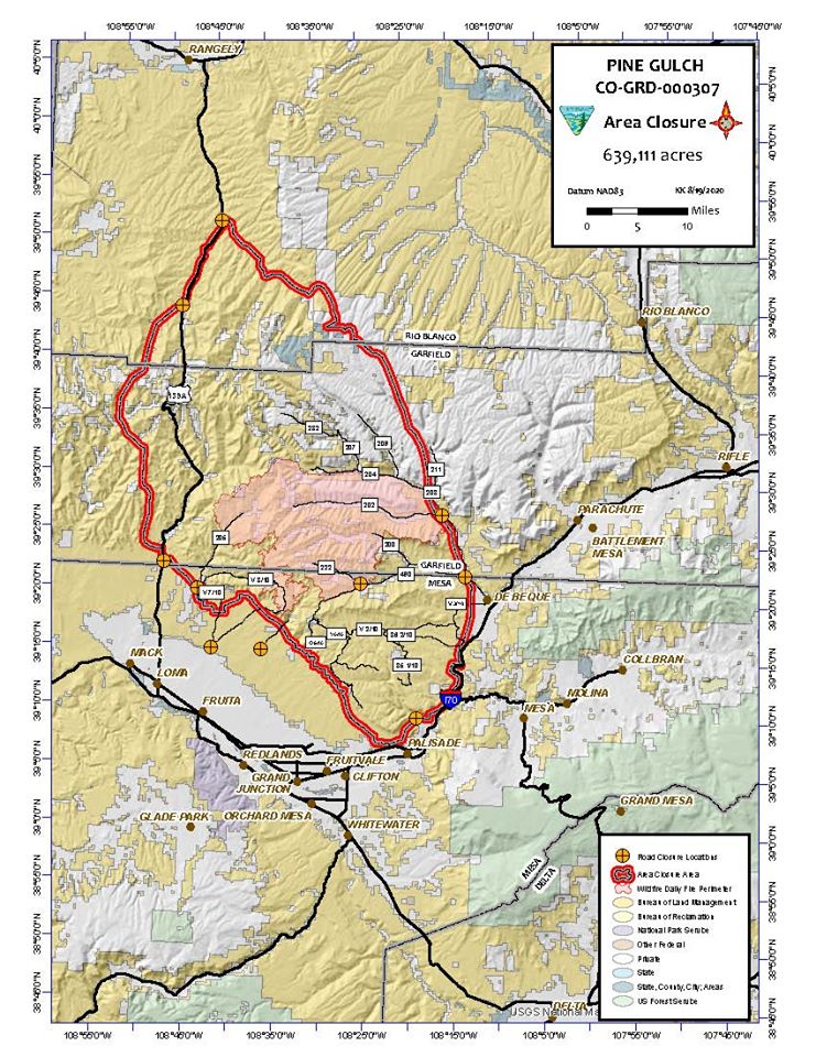
BLM Issues Closure Notice Aug 20 2020
Related Incident:
Publication Type: Closures
On August 20, the Bureau of Land Management issued a Closure Notice due to the Pine Gulch Fire. Please read the complete document in the PDF file at the bottom of this page. Also please see the link to the associated map of the closure.
BLM lands north of Loma, Fruita, Grand Junction, and Palisade, starting at the Bookcliffs; includes North Fruita Desert SRMA Campground; west and north of DeBeque on CR-204 and CR-211; from this point north on Rio Blanco CR-26A to intersection with CR-103; due west from CR-28 to CR-27; north on CR-27 to HWY 139; south on HWY 139 to Trail Canyon BLM RD 1056; south on BLM RD 1056 towards Atchee; following Demeree Canyon south; crossing HWY 139 and west to base of Bookcliffs.
More information can be found at these websites: https://www.facebook.com/BLMColorado
https://www.blm.gov/office/grand-junction-field-office