
Red Salmon Complex 8112020 PM Update
Related Incident:
Publication Type: News
Current Situation: The Red Salmon Complex is 8,024 acres and 35% contained. The Red and Salmon fires are burning in the Trinity Alps Wilderness on the Six Rivers and Shasta-Trinity National Forests. Both fires are being managed for full suppression. The reduction in acreage is because the Jones Point Fire has transitioned back to the Hoopa Valley Tribe. It is 137 acres and 91% contained.
Red Fire: The fire is 7,257 acres and 19% contained. Crews brought fire along the western edge of the Red Fire heading toward Mill Creek Gap. This fire eventually will connect on the northern perimeter near the South Fork of Red Cap Creek and Black Mountain. From the North Fork of Mill Creek, crews are firing south along Pack Saddle Ridge. Previous firing operations are connecting to the main body of the fire providing greater security for containment lines.
Salmon Fire: This fire is 767 acres and 89% contained. There is containment line all the way around the fire. All firing operations along containment lines are holding and backing downhill. Mop-up and patrol operations will be continued around the fire.
Weather: Tonight, temperatures will be cooler with good relative humidity recovery, however winds are forecast to be slightly stronger over the fire area.
Air quality: Heavy low-level smoke continues to drain into valley bottoms near the fire area and along the Bigfoot Highway affecting Orleans, Weitchpec, Hoopa and other communities in this region. These areas are expected to see periods of Unhealthy air quality with improving conditions late in the day. An air resource advisor is providing daily smoke forecasts and air quality information. Refer to fires.airfire.org/outlooks/NWCalifornia.
Closures: The Red-Salmon Fire Complex Forest Closure takes effect on August 8, 2020. All National Forest System roads within the Red-Salmon Fire Complex Closure Area are closed as well as: Forest Road Nos. 07N53 (Grizzly Camp), 07N15 (Fawn Ridge), 10N05 (Upper Leary Creek), 10N01 (Trinity Summit), and 07N10 (Lone Pine Ridge). All National Forest System trails within the Red-Salmon Fire Complex Closure Area are closed as well as: Forest Trail Nos. 6E04 (Orleans Mt Trail), 5438 (Nordheimer), 12W08 (East Fork New River), and 12W02 (Salmon Summit). Big Rock River Access.
COVID-19: COVID-19 precautions are a priority at all incident camps with daily temperature screenings of personnel and implementing measures such as wearing face coverings and social distancing to prevent coronavirus spread. Community and firefighter safety are a top priority of both the incident management team and the National Forests.Red Salmon Complex 8112020 AM Update
Related Incident:
Publication Type: News
Current Situation: The Red Salmon Complex is 8,138 acres and 35% contained. The Jones Point Fire will be transitioning back to the Hoopa Valley Tribe at 6:00 pm tonight. The Red and Salmon fires are burning in the Trinity Alps Wilderness on the Six Rivers and Shasta-Trinity National Forests. All three fires are being managed for full suppression. Firing operations will pick up today around both the Red and Salmon fires, this combined with continued interior burning will produce more smoke throughout the entirety of the fire.
Red Fire: The fire is 7,234 acres and 17% contained. Fire behavior is expected to stay active in pockets of unburned fuel with group tree torching and short up-slope runs. Increased smoke production is expected in areas where firing operations will be conducted to tie in with the main body of the fire. The fire pushed the line along Packsaddle Ridge and crews successfully caught several slopovers while they worked to keep firing operations ahead of the progressing fire.
Crews will bring fire along the western edge of the Red Fire heading toward Mill Creek Gap. This fire eventually will connect on the northern perimeter near the South Fork of Red Cap Creek and Black Mountain. From the North Fork of Mill Creek, crews are firing south along Pack Saddle Ridge. Previous firing operations are beginning to connect to the main body of the fire and provide greater security for containment lines.
Salmon Fire: This fire is 767 acres and 89% contained. There is containment line all the way around the fire. Crews connected firing operations from the north to the Salmon Fire and will be burning from Salmon Mountain south to widen the depth of containment line. Mop-up and patrol operations will continue around the fire cleaning up areas of heat and ensuring containment lines hold.
Jones Point Fire: The Jones Point Fire is 137 acres and 75% contained. Last night, firefighters patrolled the line for heat. Today, mop-up operations will progress, focusing on isolated heat located with infrared flight over the fire last night.
Weather: Moderate instability will remain today as a weak upper low pressure begins to drift over the fire area. Today, temperatures will cool by about 5 degrees; however, a drier air mas will arrive bringing a slight increase in humidity.
Air quality: Heavy low-level smoke continues to drain into valley bottoms near the fire area and along the Bigfoot Highway affecting Orleans, Weitchpec, Hoopa and other communities in this region. These areas are expected to see periods of Unhealthy air quality with improving conditions late in the day. Westerly winds yesterday drifted higher level smoke east of the fire affecting communities such as Etna. These west winds remain today and smoke impacts in the Unhealthy for Sensitive Groups are expected for Etna and the Scott Valley today. Higher level smoke and haze is being transported far the northeast.
An air resource advisor is providing daily smoke forecasts and air quality information. Refer to fires.airfire.org/outlooks/NWCalifornia.
Closures: The Red-Salmon Fire Complex Forest Closure takes effect on August 8, 2020. All National Forest System roads within the Red-Salmon Fire Complex Closure Area are closed as well as: Forest Road Nos. 07N53 (Grizzly Camp), 07N15 (Fawn Ridge), 10N05 (Upper Leary Creek), 10N01 (Trinity Summit), and 07N10 (Lone Pine Ridge). All National Forest System trails within the Red-Salmon Fire Complex Closure Area are closed as well as: Forest Trail Nos. 6E04 (Orleans Mt Trail), 5438 (Nordheimer), 12W08 (East Fork New River), and 12W02 (Salmon Summit). Big Rock River Access.
COVID-19: COVID-19 precautions are a priority at all incident camps with daily temperature screenings of personnel and implementing measures such as wearing face coverings and social distancing to prevent coronavirus spread. Community and firefighter safety are a top priority of both the incident management team and the National Forests.Smoke Outlook 8112020
Related Incident:
Publication Type: News
Special Statement
The North Coast Unified Air Quality Management District has issued an air quality advisory for the communities in and around Orleans and Hoopa.
Fire
Fire activity is expected to remain active today and moving
forward with continued smoke production. Detailed fire
information can be found at:
https://inciweb.nwcg.gov/incident/6891
Smoke
Heavy low-level smoke continues to drain into valley bottoms near the fire area and along the Bigfoot Highway affecting Orleans, Weitchpec, Hoopa and other communities in this region. These areas are expected to see periods of Unhealthy air quality with improving conditions late in the day. Westerly winds yesterday drifted higher level smoke east of the fire affecting communities such as Etna. These west winds remain today and smoke impacts in the Unhealthy for Sensitive Groups are expected for Etna and the Scott Valley today. Higher level smoke and haze is being transported far the northeast.
Red Salmon Complex 8102020 PM update
Related Incident:
Publication Type: News
Current Situation: The Red Salmon Complex is 7,053 acres and 35% contained. Fire activity picked up today with hotter and dryer temperatures over the area. The Jones Point fire located on the Hoopa Valley Reservation, southwest of the Red and Salmon Fire, started August 8 and has been added to the complex. The Red and Salmon fires are burning in the Trinity Alps Wilderness on the Six Rivers and Shasta-Trinity National Forests. All three fires are being managed for full suppression.
Red Fire: Fire behavior increased today with short uphill runs on the west flank of the fire and interior single tree torching. The fire is 6,155 acres and 17% contained. The north flank of the fire held in place and crews will patrol the fire looking for heat and resume firing operations as conditions allow. Firefighters will be conducting burning operations from the confluence of the forest boundaries near Salmon Mountain and taking fire south toward the Salmon Fire with the goal of tying the two fires together. Crews brought fire along the western edge of the Red Fire heading north from the North Fork of Mill Creek toward Forest Road 9N31. This fire eventually will connect to the northern perimeter near the South Fork of Red Cap Creek and Black Mountain. From the North Fork of Mill Creek, crews are firing south along Pack Saddle Ridge.
Salmon Fire: This fire is 761 acres and 89% contained. There is containment line all the way around the fire. Today, firefighters worked to strengthen containment lines and continued mop-up around the fire.
Jones Point Fire: The Jones Point Fire is 137 acres and 75% contained. Firefighters strengthened containment lines and continued mop-up operations. Nightshift will patrol the fire for heat.
Weather: Tonight, temperatures are expected to remain warm with poor humidity recovery over the Red and Salmon Fire. The Jones Point Fire is expected to have good humidity recovery aiding fire suppression efforts.
Air quality: Smoky conditions are forecast across the area. Early in the day expect drainage bottoms, especially along the Highway 96 corridor between Willow Creek and Somes Bar, to experience increased smoke impacts. Areas southeast of the fire may see increased smoke levels in the afternoon and overnight. An air resource advisor is providing daily smoke forecasts and air quality information. Refer to fires.airfire.org/outlooks/NWCalifornia.
Closures: The Red-Salmon Fire Complex Forest Closure takes effect on August 8, 2020. All National Forest System roads within the Red-Salmon Fire Complex Closure Area are closed as well as: Forest Road Nos. 07N53 (Grizzly Camp), 07N15 (Fawn Ridge), 10N05 (Upper Leary Creek), 10N01 (Trinity Summit), and 07N10 (Lone Pine Ridge). All National Forest System trails within the Red-Salmon Fire Complex Closure Area are closed as well as: Forest Trail Nos. 6E04 (Orleans Mt Trail), 5438 (Nordheimer), 12W08 (East Fork New River), and 12W02 (Salmon Summit). Big Rock River Access.
COVID-19: COVID-19 precautions are a priority at all incident camps with daily temperature screenings of personnel and implementing measures such as wearing face coverings and social distancing to prevent coronavirus spread. Community and firefighter safety are a top priority of both the incident management team and the National Forests.
###
Emergency Closure News Release for Red Salmon Complex eff Aug 8 2020
Related Incident:
Publication Type: Closures
Emergency Closure Order for Red Salmon Complex
YREKA, Calif. — An emergency closure order has been implemented on the Klamath, Shasta-Trinity and Six Rivers National Forest lands to provide for public safety and to facilitate wildfire suppression efforts for the Red Salmon Complex. The temporary closure order was implemented due to extreme fire behavior—the result of many years of drought, heavy fuel loading and erratic winds. The closure order will remain in effect until the fire is declared out. It is difficult to predict when that will occur so forest visitors planning activities for the weeks or months ahead in the closure area should plan for an alternative area if the need becomes necessary.
Going into or being on National Forest lands, roads, or trails within the closure area is prohibited. The order applies to the following National Forest System roads in the closure area: 07N53 (Grizzley Camp); 07N15 (Fawn Ridge); 10N05 (Upper Leary Creek) and 10N01 (Trinity Summit). And the order applies to the following National Forest System trails in the closure area: 6E04 (Orleans Mt. Trail); 5438 (Nordheimer); 12W08 (East Fork New River) and 12W02 (Salmon Summit).
It is important to understand that the closure order only applies to National Forest land, roads and trails within the closure order boundary. The following persons are exempt from this order: persons with Forest Service Permits specifically exempting them from the order; Federal, State or local officers of an organized rescue or fire fighting force; and owners or lessees of land in the closure area needing access to their property. Refer to the one page closure order for specific details.
East Fork Trailhead located about six miles northeast of Denny, California serves as a easily locatable starting point for the boundary of the Red Salmon Closure area. From East Fork Trailhead the boundary travels east about four miles to Jakes Upper Camp and at that point turns north and continues about 10 miles. At that 10 mile point the boundary turns west for two miles before continuing north seven miles to Methodist River Access on Highway 93. The boundary continues approximately 6 miles northwest along the northwest side of Highway 93 to Quail Flat.
At Quail Flat the boundary turns west and continues for one mile to Nordheimer Trailhead. From Nordheimer the boundary turns south for two miles to Horn Creek Gap. From Horn Creek Gap the boundary turns west for 11 miles. At the eleven mile point the boundary turns south for three miles to an intersection with the northwest corner of the property line for the Hoopa Valley Indian Reservation. The boundary parallels the eastern boundary of the reservation for approximately 11 miles to Tish Tang Trailhead. From Tish Tang the boundary travels about two miles south, turns east for one mile, turns south for about two miles, turns east for one mile and then south for one mile. At that point, approximately two miles northeast of Grooves Prairie Campground, the boundary turns east and travels about nine miles back to East Fork Trailhead.
A one page closure order, a map of the closure area and a legal description of the boundary of the closure is available on the Klamath National Forest website at https://www.fs.usda.gov/alerts/klamath/alerts-notices
Smoke Outlook 8102020
Related Incident:
Publication Type: News
Smoke Outlook for 8/10 - 8/11
Fire
A red flag warning has been issued today due to dry and very unstable conditions. Large fire growth is possible today. This forecast also includes areas potentially impacted by smoke from the Jones Point Fire.
Smoke
Smoky conditions are forecast across the area today as large fire growth may occur. Early in the day expect drainage bottoms, especially along the Highway 96 corridor between Willow Creek and Somes Bar, to experience increased smoke impacts. In the afternoon, ventilation is anticipated to improve as winds increase and shift. Areas southeast of the fire may see increased smoke levels in the afternoon and overnight.
Other
If you begin to notice health effects from smoke, you are encouraged to follow the "actions to protect yourself" listed below. Always remember, if you smell smoke you are breathing smoke.Red Salmon Complex 8102020 AM Update
Related Incident:
Publication Type: News
Current Situation: The Red Salmon Complex is 7,031 acres and 30% contained. A red flag warning is in effect over the fire area because of high temperatures and unstable air aloft. The Jones Point fire located on the Hoopa Valley Reservation, southwest of the Red and Salmon Fire, started August 8 and has been added to the complex. The Red and Salmon fires are burning in the Trinity Alps Wilderness on the Six Rivers and Shasta-Trinity National Forests. All three fires are being managed for full suppression.
Red Fire: With significant fire weather forecasted, the possibility of long-range spotting and short-duration crown runs exists. Fire behavior has been moderated over the past week as an inversion held in place. That inversion has weakened, increasing the possibility that communities will see an increased smoke column from the Red Fire. The fire is 6,146 acres and 14% contained. Along the northern edge, firefighters have strengthened and improved the line from Black Mountain to Salmon Summit Trailhead as well as built black line from Black Mountain west utilizing strategic firing operations. These burns have created a barrier that will be used to stop the progression of the fire. The west edge of the fire is holding, and crews are monitoring and patrolling. Firefighters will be firing from the confluence of the forest boundaries near Salmon Mountain and taking fire south toward the Salmon Fire with the goal of tying the two fires together.Crews brought fire along the western edge of the Red Fire heading north from the North Fork of Mill Creek toward Forest Road 9N31. This fire eventually will connect to the northern perimeter near the South Fork of Red Cap Creek and Black Mountain. From the North Fork of Mill Creek, crews are firing south along Pack Saddle Ridge.
Salmon Fire: This fire is 759 acres and 70% contained. Crews will strengthen containment lines today as well as construct hose lays along Backbone Ridge heading south. The hose lays will be used to secure firing operations when the opportunity presents itself.
Jones Point Fire: Firefighters have built containment line around the 126-acre Jones Point Fire and will work on mopping up any remaining heat sources today. Crews worked throughout the night to contain the fire and resources will be reassigned to other areas as needed.
Weather: A red flag warning has been issued over the fire area for increased temperatures, low relative humidity and unstable air. The combination of factors could lead to increased fire behavior and a more noticeable smoke column than has been seen in recent days.
Air quality: Smoky conditions are forecast across the area today as large fire growth may occur. Early in the day expect drainage bottoms, especially along the Highway 96 corridor between Willow Creek and Somes Bar, to experience increased smoke impacts. In the afternoon, ventilation is anticipated to improve as winds increase and shift. Areas southeast of the fire may see increased smoke levels in the afternoon and overnight. An air resource advisor is providing daily smoke forecasts and air quality information. Refer to fires.airfire.org/outlooks/NWCalifornia.
Closures: The Red-Salmon Fire Complex Forest Closure takes effect on August 8, 2020. All National Forest System roads within the Red-Salmon Fire Complex Closure Area are closed as well as: Forest Road Nos. 07N53 (Grizzly Camp), 07N15 (Fawn Ridge), 10N05 (Upper Leary Creek), 10N01 (Trinity Summit), and 07N10 (Lone Pine Ridge). All National Forest System trails within the Red-Salmon Fire Complex Closure Area are closed as well as: Forest Trail Nos. 6E04 (Orleans Mt Trail), 5438 (Nordheimer), 12W08 (East Fork New River), and 12W02 (Salmon Summit). Big Rock River Access.
COVID-19: COVID-19 precautions are a priority at all incident camps with daily temperature screenings of personnel and implementing measures such as wearing face coverings and social distancing to prevent coronavirus spread. Community and firefighter safety are a top priority of both the incident management team and the National Forests.
Red Salmon Complex 892020 PM Update
Related Incident:
Publication Type: News
Current Situation: The Red Salmon Complex 5,977 acres and 30% contained. A red flag warning is in effect through tomorrow over the fires area. Today, California Interagency Incident Management Team 14 has taken management of the Jones Point fire located on the Hoopa Valley Reservation, southwest of the Red and Salmon Fire. The Red and Salmon fires are burning in the Trinity Alps Wilderness on the Six Rivers and Shasta-Trinity National Forests. The Jones Point Fire is burning on the Hoopa Valley Reservation. All three fires are being managed for full suppression.
Red Fire: Fire activity was moderate today. The fire is 5,218 acres and 14% contained. Today, crews made significant progress along the fire’s northern edge through strategic firing operations which put fire on the ground and cleaned up unburned fuel along the line from Black Mountain west along Lubbs Trail and Forest Road 10N01 to the Salmon Summit Trailhead. From there they worked to connect firing operations with the Salmon Fire to just south of Salmon Mountain. These firing operations are backing down from containment lines to the main fire. Crews continue to strengthen indirect contingency lines. On the west side of the fire, crews focused on cleaning up the line and more firing operations along Packsaddle Ridge north of the North Fork of Mill Creek. Firing operations on the north and west sides of the fire will eventually be tied together forming a solid containment line to hold the fire.
Salmon Fire: This fire is 759 acres and 70% contained. Today, crews strengthened containment lines around Salmon Mountain and worked to connect lines around the southwest corner of the fire. The fire is staying within its current footprint as any activity comes from unburned pockets of fuel within containment lines.
Jones Point Fire: The Jones Point Fire started August 8 on the Hoopa Valley Reservation just north of Willow Creek, CA. This fire is a human caused wildfire. It is 132 acres. Crews have line around the entirety of the fire. The line is a mix of dozer line, handline and wet line. This fire has been taken under the command of the team and is part of the Red Salmon Complex. Tonight, crews will work to build more line and improve existing containment lines.
Weather: A red flag warning has been issued over the fire area through Monday evening for increased temperatures and low relative humidity. Tonight, humidity levels will remain low in the Red and Salmon fire areas while Jones Point will see increased humidity.
Air quality: Widespread smokey conditions are possible as large fire, growth might occur. In the morning and early afternoon expect drainage bottoms, especially along the Highway 96 corridor between Willow Creek and Somes Bar, to experience increased smoke impacts. An air resource advisor is providing daily smoke forecasts and air quality information. Refer to fires.airfire.org/outlooks/NWCalifornia.
Closures: The Red-Salmon Fire Complex Forest Closure takes effect on August 8, 2020. All National Forest System roads within the Red-Salmon Fire Complex Closure Area are closed as well as: Forest Road Nos. 07N53 (Grizzly Camp), 07N15 (Fawn Ridge), 10N05 (Upper Leary Creek), 10N01 (Trinity Summit), and 07N10 (Lone Pine Ridge). All National Forest System trails within the Red-Salmon Fire Complex Closure Area are closed as well as: Forest Trail Nos. 6E04 (Orleans Mt Trail), 5438 (Nordheimer), 12W08 (East Fork New River), and 12W02 (Salmon Summit). Big Rock River Access.
COVID-19: COVID-19 precautions are a priority at all incident camps with daily temperature screenings of personnel and implementing measures such as wearing face coverings and social distancing to prevent coronavirus spread. Community and firefighter safety are a top priority of both the incident management team and the National Forests.
Red Salmon Complex 892020 AM Update
Related Incident:
Publication Type: News
Current Situation: A red flag warning has been issued today and tomorrow for the fire area. The Red Salmon Complex 5,977 acres and 12% contained. Both fires are burning in the Trinity Alps Wilderness on the Six Rivers and Shasta-Trinity National Forests. Crews are utilizing minimum impact suppression techniques in the wilderness as well as control lines from past fires as contingency lines.
Red Fire: Fire activity increased yesterday afternoon crossing Red Cap Creek on the west flank. The fire is 5,218 acres and 5% contained. Yesterday, crews made significant progress along the fire’s northern edge through strategic firing operations putting fire on the ground from just east of Black Mountain heading west along Lubbs Trail and Forest Road 10N01 to the Salmon Summit Trailhead. From there they worked to connect the firing operations with the Salmon Fire to just south of Salmon Mountain. These firing operations are backing down from containment lines to the main fire to prevent fire from spreading across it. Today, crews will strengthen indirect contingency lines on the west flank of the fires.
Salmon Fire: This fire is 759 acres and 29% contained. Yesterday, firefighters finished both direct and indirect containment lines around the fire. Today, crews will strengthen those containment lines and conduct mop-up operations around the fire. The fire is staying within its current footprint as any activity comes from unburned pockets of fuel within containment lines.
Weather: A red flag warning has been issued over the fire area starting today through Monday for increased temperatures and low relative humidity. The atmosphere is unstable enough today where intense heat could break the weak mid-level inversion and produce a convection column.
Air quality: Widespread smokey conditions are possible today as large fire, growth may occur. In the morning and early afternoon expect drainage bottoms, especially along the Highway 96 corridor between Willow Creek and Somes Bar, to experience increased smoke impacts. An air resource advisor is providing daily smoke forecasts and air quality information. Refer to fires.airfire.org/outlooks/NWCalifornia.
Closures: The Red-Salmon Fire Complex Forest Closure takes effect on August 8, 2020. All National Forest System roads within the Red-Salmon Fire Complex Closure Area are closed as well as: Forest Road Nos. 07N53 (Grizzly Camp), 07N15 (Fawn Ridge), 10N05 (Upper Leary Creek), 10N01 (Trinity Summit), and 07N10 (Lone Pine Ridge). All National Forest System trails within the Red-Salmon Fire Complex Closure Area are closed as well as: Forest Trail Nos. 6E04 (Orleans Mt Trail), 5438 (Nordheimer), 12W08 (East Fork New River), and 12W02 (Salmon Summit). Big Rock River Access.
COVID-19: COVID-19 precautions are a priority at all incident camps with daily temperature screenings of personnel and implementing measures such as wearing face coverings and social distancing to prevent coronavirus spread. Community and firefighter safety are a top priority of both the incident management team and the National Forests.
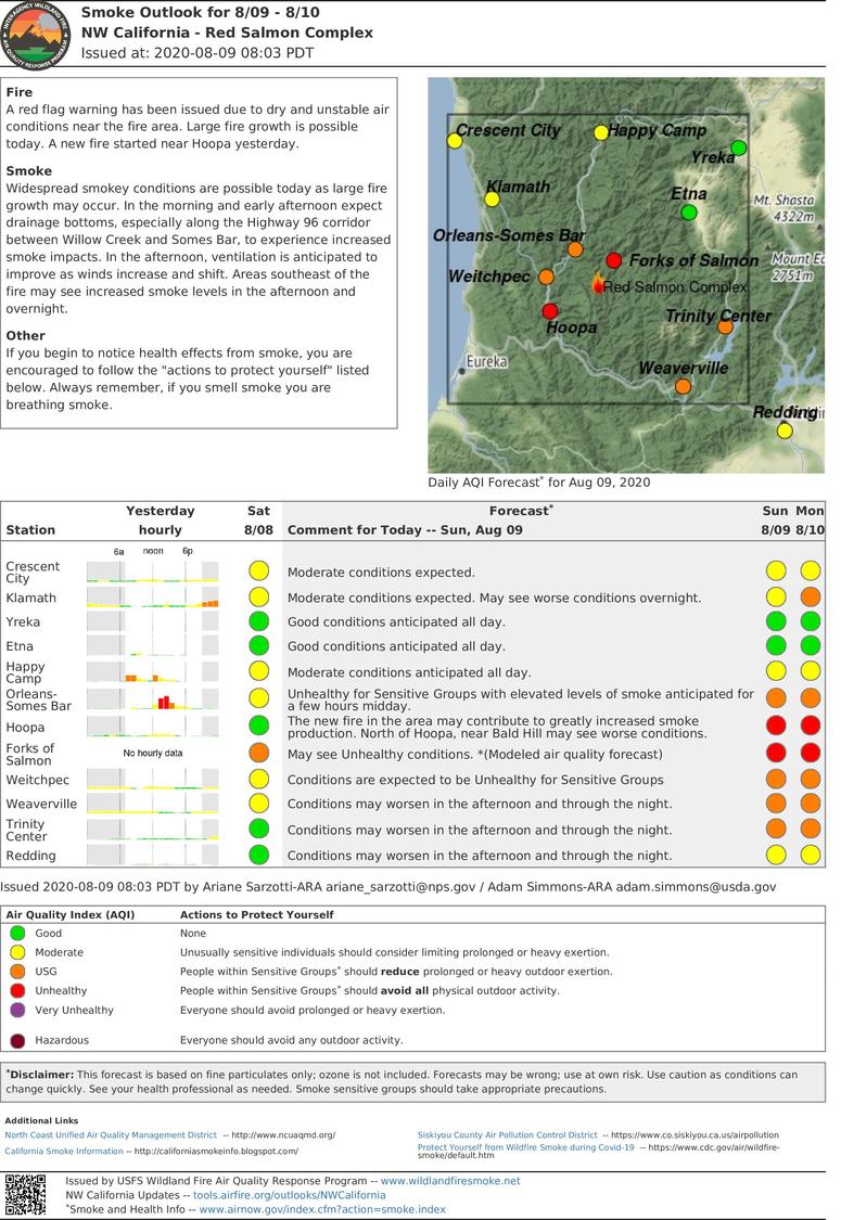
Smoke Outlook 892020
Related Incident:
Publication Type: News
Fire
A red flag warning has been issued due to dry and unstable air conditions near the fire area. Large fire growth is possible today. A new fire started near Hoopa yesterday.
Smoke
Widespread smokey conditions are possible today as large fire growth may occur. In the morning and early afternoon expect drainage bottoms, especially along the Highway 96 corridor between Willow Creek and Somes Bar, to experience increased smoke impacts. In the afternoon, ventilation is anticipated to improve as winds increase and shift. Areas southeast of the fire may see increased smoke levels in the afternoon and overnight.
Other
If you begin to notice health effects from smoke, you are encouraged to follow the "actions to protect yourself" listed below. Always remember, if you smell smoke you are breathing smoke.