
Emergency Trail Segment Closures in the Cow Fire Area
Related Incident:
Publication Type: Closures
Several back-country trail segments have been closed for public safety and firefighter focus. All segments are on R35E T18S Section 31 and R35E T19S Sections 4,5,6,8,9,17 and 18 of the Templeton Mountain topo map. The segments are:
w 3507 from Templeton Cow Camp east to the intersection with 3412/3512 near Strawberry Creek
w 3510 from the intersection with 3512 near Strawberry Creek east to the South Fork of the Kern River
w 3512 from the intersection with 3510 (near Strawberry Creek) south to Schaeffer Stringer near Iron Spring
w 3511 from where it intersects 3512 south to where it crosses Schaeffer Stringer
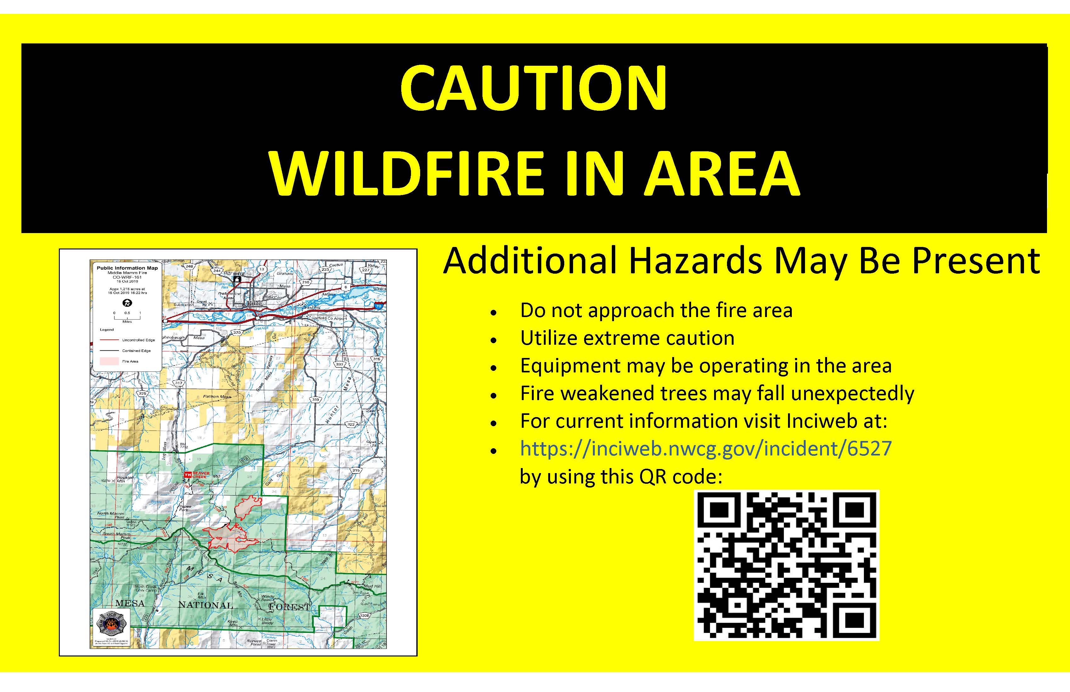
October 15 Middle Mamm Fire Update
Related Incident:
Publication Type: News
October 15, 2019, 2:00 p.m.
White River National Forest
Dan Nielsen, Incident Commander
Danielle Shedden, Incident Commadner (Trainee)
Middle Mamm Fire to Transition to Local Control
Current Situation: The Middle Mamm Fire saw a mild increase in fire activity on Monday due to moderate afternoon winds. The fire pushed northward in Division Z causing a small increase in acreage. The fire is now 1069 acres. Containment remains at 23% of the total perimeter to contained.
On Monday, fire crews continued to monitor and patrol the fire’s perimeter during the morning. During the afternoon crews switched to holding operations due to increased wind activity. These operations allowed crews to monitor specific sections of the fire’s perimeter while remaining available to respond to any spot fires.
On Tuesday morning at 6:00 a.m., the fire will transition back to a local Type 4 Organization under the leadership of Incident Commander Dan Nielson and Incident Commander (Trainee) Danielle Shedden. The organization will be staffed by approximately 70 personnel consisting of several hand crews, engines and aircraft. These resources will continue to conduct patrol and monitor operations while completing mop up and suppression repair in areas near values at risk.
On Sunday, fire crews used favorable weather conditions to make significant progress in securing fire line and mop up operations. The fire consumed interior fuels and produced smoke from within the fire’s perimeter. Suppression repair activities took place as crews rehabilitated line and created water bars to mitigate erosion.
Weather & Fuel Conditions: Temperatures are expected to range from the mid-50s to low 60s and minimum humidity is anticipated to be 10-15%. Downslope winds will be light in the early morning before switching to light upslope winds by mid-morning. In the afternoon there will be westerly winds with gusts. Temperatures are projected to peak in the mid-70s midweek before dropping into the high 40s over the weekend.
Evacuations and Closures: A revised area closure is in effect for the area of the fire on the White River National Forest. Closure orders on BLM lands near the fire, along with the Grand Mesa National Forest has been lifted. These closures are in place to ensure firefighter and public safety.
Closures may affect access for first rifle season hunters in Game Management Unit (GMU) 42. The revised closure prohibits unauthorized use on US Forest Service lands in the entire Middle Mamm drainage, Gant Gulch, and a portion of Battlement Trail A (Forest System Trail 2160) remain closed. All Forest Service trails and roads within the defined area are closed to public access.
Additional information on these closures, along with a map for alternative access to GMU 42 is available on the Middle Mamm Inciweb page at https://go.usa.gov/xVzW9.
Fire Restrictions: There are currently no fire restrictions in place on the White River National Forest.
Temporary Flight Restrictions: A temporary flight restriction is in place for the area immediate around and within the Middle Mamm Fire. The public is reminded that drones are not allowed in or around active wildfires – if you fly we can’t!
Fire Statistics:
Size: 1069 acresContainment: 23%
Total Personnel: 70
Cause: Lightning
Location: 10 miles south of Rifle, CO
Contact Information:
Public Information Office: (970) 930-1548
Email: 2019.middlemamm@firenet.gov
Facebook: facebook.com/MiddleMammFire/
October 14 Middle Mamm Fire Update
Related Incident:
Publication Type: News
Middle Mamm Fire Update
October 14, 2019 – 10:00 a.m.
Rocky Mountain Incident Management Team Black
Troy Hagan, Incident Commander
Public Information Office: (970) 930-1548
Hours of Operation: 8 a.m. - 8 p.m.
Middle Mamm Fire Reaches 23% Containment
Current Situation: Firefighters continue to make progress on the Middle Mamm Fire.
The Middle Mamm Fire is being managed under multiple strategies. Approximately 34% of the perimeter is identified to be contained where the fire could threaten values at risk, specifically where the fire is near private lands or infrastructure. Of this 34% that will be contained, 23% of the containment line was completed as of Sunday evening.
On Sunday, fire crews used favorable weather conditions to make significant progress in securing fire line and mop up operations. The fire consumed interior fuels and produced smoke from within the fire’s perimeter. Suppression repair activities took place as crews rehabilitated line and created water bars to mitigate erosion.
Three hand crews, five engines, and two helicopters will remain assigned to the incident on Monday. These crews will continue monitoring and patrolling established lines while performing mop up and rehabilitation on eligible areas.
Weather & Fuel Conditions: Temperatures are expected to range from the mid-50s to low 60s and minimum humidity is anticipated to be 10-15%. Southwest winds will be light in the morning and are forecasted to shift to moderate westerly winds with gusts around noon. Temperatures are projected to peak in the mid-70s midweek before dropping into the high 40s over the weekend.
Evacuations and Closures: Closures are in effect for the area of the fire on the White River and the Grand Mesa national forests. Additionally, a closure order is in place on BLM lands near the fire. These closures are in place to ensure firefighter and public safety.
Closures may affect access for first rifle season hunters in Game Management Unit (GMU) 42. A closure is in effect on West Mamm Road (County Road 319) approximately five miles south of Airport Road. Hunters should be aware of closure areas before entering public lands. A portion of Forest Service Trail (FST) 2160 (Battlement Trail) remains closed between the intersection of Beaver Creek Trail (FST 2161) and Mudd Hill Road (Forest Road 271); another portion of Battlement Trail (FST 527) is closed between the intersection of Brush Creek Trail (FST 529) and East Brush Creek Trail (FST 504).
Additional information on these closures, along with a map for alternative access to GMU 42 is available on the Middle Mamm Inciweb page at https://go.usa.gov/xVzW9.
Fire Restrictions: There are currently no fire restrictions in place on the White River National Forest, in Garfield County, or on BLM-Colorado River Valley Field Office lands.
Temporary Flight Restrictions: A temporary flight restriction is in place for the area immediate around and within the Middle Mamm Fire. The public is reminded that drones are not allowed in or around active wildfires – if you fly we can’t!
For More Information:
Public Information Office: (970) 930-1548
InciWeb: https://inciweb.nwcg.gov/incident/6527/
Facebook: facebook.com/MiddleMammFire/
Middle Mamm Fire Statistics:
Size: 1007 acres
Containment: 23%
Total Personnel: 177
Cause: Lightning
Location: Approximately 10 miles south of Rifle, CO
October 13 Middle Mamm Fire Update
Related Incident:
Publication Type: News
Middle Mamm Fire Update
October 13, 2019 – 10:00 a.m.
Rocky Mountain Incident Management Team Black
Troy Hagan, Incident Commander
Public Information Office: (970) 930-1548
Hours of Operation: 8 a.m. - 8 p.m.
Crews Make Progress on Middle Mamm Fire on Saturday
Current Situation: Saturday was another day of minimal activity for the Middle Mamm Fire. The fire remains at 1007 acres. The interior of the fire produced smoke from pockets of unburned fuels as afternoon temperatures warmed and winds became breezier. These interior smokes are expected to remain active as the fire continues to work through fuels on the forest floor in healthy aspen stands. Fire activity on the perimeter remained minimal.
Crews accomplished a significant amount of mop up in various locations around the fire’s perimeter. Crews also began conducting repair work on secured control lines in the East Mamm creek drainage, rehabilitating impacts of suppression operations and restoring the landscape to its natural state.
On Sunday, firefighters will continue mop up operations. Fire activity is expected to be more active on south-facing slopes with more exposure to sun and places where slope aligns with wind. Smoke will continue to be visible from I-70 between Silt and Glenwood Springs.
Weather & Fuel Conditions: Temperatures are expected to range from the mid to high 50s and minimum humidity will be 8-13% with light southwest winds in the morning that will shift to the northwest around noon. Temperatures are projected to rise over the weekend, reaching the high 60s next week before dropping back into the 50s next weekend.
Evacuations and Closures: Closures are in effect for the area of the fire on the White River and the Grand Mesa national forests. Additionally, a closure order is in place on BLM lands near the fire. These closures are in place to ensure firefighter and public safety.
Closures may affect access for first rifle season hunters in Game Management Unit (GMU) 42. A closure is in effect on West Mamm Road (County Road 319) approximately five miles south of Airport Road. Hunters should be aware of closure areas before entering public lands. A portion of Forest Service Trail (FST) 2160 (Battlement Trail) remains closed between the intersection of Beaver Creek Trail (FST 2161) and Mudd Hill Road (Forest Road 271); another portion of Battlement Trail (FST 527) is closed between the intersection of Brush Creek Trail (FST 529) and East Brush Creek Trail (FST 504).
Additional information on these closures, along with a map for alternative access to GMU 42 is available on the Middle Mamm Inciweb page at https://go.usa.gov/xVzW9.
Fire Restrictions: There are currently no fire restrictions in place on the White River National Forest, in Garfield County, or on BLM-Colorado River Valley Field Office lands.
Temporary Flight Restrictions: A temporary flight restriction is in place for the area immediately around the Middle Mamm Fire. The public is reminded that drones are not allowed around active wildfires – if you fly we can’t!
For More Information:
Public Information Office: (970) 930-1548
InciWeb: https://inciweb.nwcg.gov/incident/6527/
Facebook: facebook.com/MiddleMammFire/
Middle Mamm Fire Statistics:
Size: 1007 acres
Containment: 2%
Total Personnel: 204
Cause: Lightning
Location: Approximately 10 miles south of Rifle, CO
October 12 Middle Mamm Fire Update
Related Incident:
Publication Type: News
Middle Mamm Fire Update
October 12, 2019 – 10:00 a.m.
Rocky Mountain Incident Management Team Black
Troy Hagan, Incident Commander
Public Information Office: (970) 930-1548
Hours of Operation: 8 a.m. - 8 p.m.
Middle Mamm Fire Remains Quiet on Friday
Current Situation: The 1007-acre Middle Mamm Fire remained quiet on Friday. For the third straight day, fire behavior was minimal after overnight precipitation on Wednesday and sub-freezing temperatures the previous two nights. Fire crews spent the day conducting mop up, identifying areas for mastication operations, and reinforcing lines. The fire remains primarily on national forest lands.
On Saturday, firefighters will work with a mastication equipment to clear and grind viable vegetation to bolster control line bordering private lands. Crews are taking advantage of favorable conditions to improve direct and indirect lines ahead of a forecasted increase in temperature in the coming days. The fire is expected to continue smolder throughout the weekend with smoke being visible from I-70 between Silt and Glenwood Springs, along with the City of Rifle.
Weather & Fuel Conditions: Temperatures in the fire area are expected to reach into the mid-50s and minimum humidity will be 9-14% with light morning winds forecast out of the southeast before shifting to the west during the afternoon. Temperatures are projected to rise over the weekend, reaching the high-60s next week before dropping back into the 50s next weekend.
Evacuations and Closures: Closures are in effect for the area of the fire on the White River and the Grand Mesa national forests. Additionally, a closure order is in place on BLM lands near the fire. These closures are in place to ensure firefighter and public safety.
Closures may affect access for first rifle season hunters in Game Management Unit (GMU) 42. A closure is in effect on West Mamm Road (County Road 319) approximately five miles south of Airport Road. Hunters should be aware of closure areas before entering public lands. A portion of Forest Service Trail (FST) 2160 (Battlement Trail) remains closed between the intersection of Beaver Creek Trail (FST 2161) and Mudd Hill Road (Forest Road 271); another portion of Battlement Trail (FST 527) is closed between the intersection of Brush Creek Trail (FST 529) and East Brush Creek Trail (FST 504). Additional information on these closures, along with a map for alternative access to GMU 42 is available on the Middle Mamm Inciweb page at https://go.usa.gov/xVzW9.
Fire Restrictions: There are currently no fire restrictions in place on the White River National Forest, in Garfield County, or on BLM-Colorado River Valley Field Office lands.
Temporary Flight Restrictions: A temporary flight restriction is in place for the area immediate around and within the Middle Mamm Fire. The public is reminded that drones are not allowed in or around active wildfires – if you fly we can’t!
For More Information:
Public Information Office: (970) 930-1548
InciWeb: https://inciweb.nwcg.gov/incident/6527/
Facebook: facebook.com/MiddleMammFire/
Middle Mamm Fire Statistics:
Size: 1007 acres
Containment: 2%
Total Personnel: 232
Cause: Lightning
Location: Approximately 10 miles south of Rifle, CO
Hunting Access to Game Management Unit 42
Related Incident:
Publication Type: Announcement
Due to the road closure at road 319, the attached map shows alternate routes into Game Management Unit 42 for hunting on National Forest Land. The options listed below correspond to the numbers listed on the attached map.
Option 1: This will give you access to the Beaver Creek Trailhead. There is parking at the trailhead, then access is by foot or horse only. The Beaver Creek trail is open, however any access off the trail to the east is under a closure order and there is no access due to the Middle Mamm Fire.
Option 2: This will give you access to the Battlement Trailhead. The access from the east side of Battlement Mesa to the trailhead is a rough road. There is parking at the trailhead and users can continue on foot or by horse. The road beyond the trailhead is extremely rough and not passible by standard pickup trucks or passenger type vehicles
Option 3: This will take you to the far southeast side of GMU 24.
Please respect private property when accessing Federal lands. Both Battlement and Beaver Creek trails cross private lands in order to access the National Forest.
October 11 Middle Mamm Fire Update
Related Incident:
Publication Type: News
Middle Mamm Fire Update
October 11, 2019 – 10:00 a.m.
Rocky Mountain Incident Management Team Black
Troy Hagan, Incident Commander
Public Information Office: (970) 930-1548
Hours of Operation: 8 a.m. - 8 p.m.
Middle Mamm Fire Experiences Minimal Activity on Wednesday
Current Situation: The 1001-acre Middle Mamm Fire experienced little fire activity on Thursday. Overnight precipitation on Wednesday totaled ½ to 2” of snow over of the fire. That snow remains in the area, which saw a high of 32 degrees on Thursday. The two type 1 helicopters spent the afternoon conducting water drops along fire’s edge reinforcing control lines adjacent to private property. Fire crews patrolled the fire, improved containment lines, identified hot spots, and mopped up where necessary. The fire remains mostly on national forest and BLM lands.
On Friday, crews are expected to continue Thursday’s work of patrolling and monitoring lines, and mopping up. Using another day of optimal conditions to their advantage, air resources will remain available to fire crews and will be utilized to reinforce the fire’s perimeter ahead of a forecasted temperature increase on Saturday. The fire is anticipated to smolder on Friday, and as temperatures warm, may produce some visible smoke in the afternoon. Smoke may be visible from I-70 between Silt and Glenwood Springs, and the city of Rifle.
Weather & Fuel Conditions: Temperatures in the fire area are expected to range from the high-30s to the mid-40s and minimum humidity will be 15-20% with light winds forecast out of the southwest. Temperatures are projected to rise over the weekend, reaching the high-60s by the beginning of next week.
Evacuations and Closures: Closures are in effect for the area of the fire on the White River and the Grand Mesa national forests. Additionally, a closure order is in place on BLM lands near the fire. These closures may impact first rifle season hunters in Game Management Unit 42 as a portion of Forest Service Trail (FST) 2160 (Battlement Trail) remains closed between the intersection of Beaver Creek Trail (FST 2161) and Mudd Hill Road (Forest Road 271), and a portion of Battlement Trail (FST 527) which is closed between the intersection of Brush Creek Trail (FST 529) and East Brush Creek Trail (FST 504). Access to West Mamm Road (County Road 319) remains under restricted access. These closures will remain in place to ensure firefighter and public safety. Additional information on these closures is available on the Middle Mamm Inciweb page.
Fire Restrictions: There are currently no fire restrictions in place on the White River National Forest, in Garfield County, or on BLM-Colorado River Valley Field Office lands.
Temporary Flight Restrictions: A temporary flight restriction is in place for the area immediate around and within the Middle Mamm Fire. On Monday, a drone incursion caused air resources to be grounded during prime flying conditions. The public is reminded that drones are not allowed in or around active wildfires – if you fly we can’t!
For More Information:
Public Information Office: (970) 930-1548
InciWeb: https://inciweb.nwcg.gov/incident/6527/
Facebook: facebook.com/MiddleMammFire/
Middle Mamm Fire Statistics:
Size: 1001 acres
Containment: 2%
Total Personnel: 175
Cause: Lightning
Location: Approximately 10 miles south of Rifle, CO
October 10 Middle Mamm Fire Update
Related Incident:
Publication Type: News
Due to an error this morning, this update was not posted at 11 a.m. when it was issued. Our apologies.
Middle Mamm Fire Update
October 10, 2019 – 10:00 a.m.
Rocky Mountain Incident Management Team Black
Troy Hagan, Incident Commander
Information Center: (970) 930-1548
Hours of Operation: 8 a.m. - 8 p.m.
Middle Mamm Fire Experiences Minimal Activity on Wednesday
Current Situation: The 1001-acre Middle Mamm Fire experienced light fire activity on Wednesday despite the winds associated with yesterday’s frontal passage. The west side of the fire experienced some increased activity as consistent afternoon winds pushed a small spot fire on to adjacent private lands, which was quickly contained. Preparations undertaken on Monday and Tuesday allowed crews to quickly and effectively respond to the situation, preventing further growth. Cooler temperatures and cloud cover moderated fire behavior in the afternoon. At 1900 hours yesterday the Rocky Mountain Type 2 Incident Management (Team Black) took command of the fire, which remains largely on national forest and BLM lands.
Favorable weather conditions on Wednesday morning aided air resources in conducting retardant and water drops on the north end of the fire, allowing crews time to reinforce both direct and indirect lines. During the afternoon, fire crews patrolled and monitored the fire as winds moved into the area from northwest Colorado. These winds caused a spot fire on private land off of the west side of the fire, which was quickly contained. Preparations undertaken on Monday and Tuesday allowed crews to quickly respond, establishing containment lines around the spot fire before it could spread.
On Thursday, crews are expected to monitor and patrol the fire. Fire behavior is expected to be minimal today with the increased humidity and cold temperatures that moved into the area overnight. Multiple air resources remained assigned to the fire including two Type 1 and one Type 2 helicopters. Single engine air tankers based in Rifle and large air tankers based in Grand Junction are available, if needed. The fire is expected to smolder through the day and smoke will be visible from I-70 between Silt and Glenwood Springs.
Weather & Fuel Conditions: Temperatures in the fire area are expected to reach the mid 30s and minimum humidity will be 23-28%. Winds are forecast to be 5-10 mph out of the northwest with afternoon gusts of up to 25 mph. Scattered snow showers in the morning and isolated snow showers in the afternoon are expected today with minimal accumulation. Temperatures are projected to remain low Thursday and Friday and will gradually increase into the weekend.
Evacuations and Closures: The Garfield County Sheriff’s Office lifted a pre-evacuation notice for residents in the Middle Mamm Creek area this morning. Closures are in effect for the area of the fire on the White River and the Grand Mesa national forests. Additionally, a closure order is in place on BLM lands near the fire. These closures are in place to ensure firefighter and public safety. Additional information on these closures is available on the Middle Mamm Inciweb page.
Fire Restrictions: There are currently no fire restrictions in place.
Temporary Flight Restrictions: A temporary flight restriction is in place for the area immediate around and within the Middle Mamm Fire. On Monday, a drone incursion caused air resources to be grounded during prime flying conditions. The public is reminded that drones are not allowed in or around active wildfires – if you fly we can’t!
For More Information:
InciWeb: https://inciweb.nwcg.gov/incident/6527/
Facebook: facebook.com/MiddleMammFire/
Fire Info Line: (970) 930-1548
Middle Mamm Fire Statistics:
Size: 1001 acres
Containment: 2%
Total Personnel: 142
Cause: Lightning
Location: Approximately 10 miles south of Rifle, CO
Drone grounds aviation resources on the Middle Mamm Fire
Related Incident:
Publication Type: News
_________________________________________________________________________
Pre-evacuation order: There is currently a soft road closure, limiting traffic to local residents at the intersection of CR 319 (West Mamm Creek) and CR 322 (Shaeffer Cut-off). This could become a hard closure with only emergency responders allowed access. Similarly, the intersection of CR 315 (Mamm Creek Road) and CR 316 (Knuckles cut-off) could be established if necessary. Residents to the south and southwest of these two points are under a pre-evacuation order and encouraged to be on high alert.
Facebook: https://www.facebook.com/MiddleMammFire/