
Air Quality Report 8819
Related Incident:
Publication Type: News
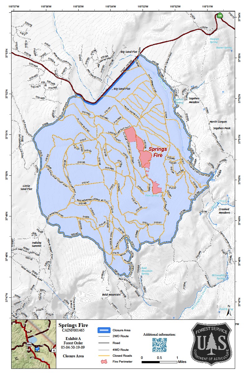
Fire
The Springs Fire, a lightning-ignited wildfire, grew last night approximately 90 more acres in lighter fuels, under continued favorable tactical firing conditions, and is now at approximately 330 acres as of this morning. Lighter fuels ahead of the fire will likely result in less daily smoke emissions over the next few days, even if daily acreages increase. Most firing today will occur in the evening, after the potential for thunderstorms passes. The pattern of slow growth and tactical firing in the evening is will likely continue today and tomorrow.
Smoke
Locally heavy smoke in the vicinity of the fire was again evident this morning over highway 120 east near the fire, with a distinct haze layer also visible over the eastern end of the Mono Basin. Reduced smoke emissions, stronger southwesterly transport winds over the fire area, along with the potential for wetter thunderstorms will likely reduce these impacts today and tomorrow. This improved dispersion will also likely mean less morning smoke/haze aloft over down the Hammil and Owens Valley in the late evening/early morning. All monitors in the forecast area are expected to remain in good range today and tomorrow
Air Quality Report 8919
Related Incident:
Publication Type: News
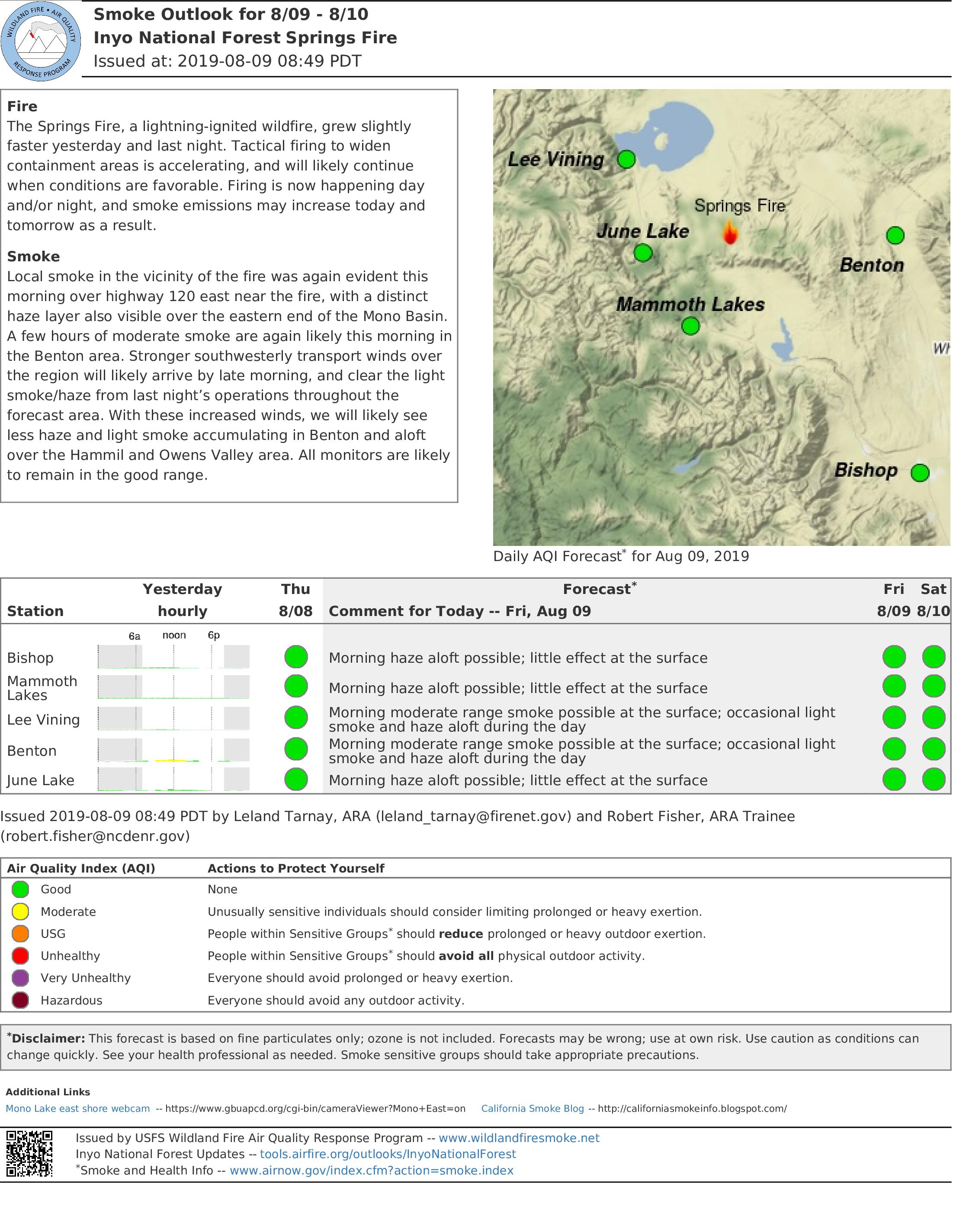
Fire
The Springs Fire, a lightning-ignited wildfire, grew slightly
faster yesterday and last night. Tactical firing to widen
containment areas is accelerating, and will likely continue
when conditions are favorable. Firing is now happening day
and/or night, and smoke emissions may increase today and
tomorrow as a result.
Smoke
Local smoke in the vicinity of the fire was again evident this
morning over highway 120 east near the fire, with a distinct
haze layer also visible over the eastern end of the Mono Basin.
A few hours of moderate smoke are again likely this morning in
the Benton area. Stronger southwesterly transport winds over
the region will likely arrive by late morning, and clear the light
smoke/haze from last night’s operations throughout the
forecast area. With these increased winds, we will likely see
less haze and light smoke accumulating in Benton and aloft
over the Hammil and Owens Valley area. All monitors are likely
to remain in the good range.
Air Quality Summary Saturday August 3 2019
Related Incident:
Publication Type: Announcement
Smoke forecastTwo fires are actively burning on the Nez Perc-Clearwater National Forest and continue to impact neighboring communities. Fire activity has decreased today due to fires receiving precipitation yesterday and last night, but drying will continue through the weekend with increased consumption on fires. Predominate west -south west winds will move more smoke into the Missoula Valley, Bitterroot Valley areas, and other areas to the east and north.The Barren Hill and Crab fire continues to produce smoke and haze impacting Powell, Id and Hamilton, Mt.
See the full forecast by clicking on the link.
Final Update Unless Significant New Activity Occurs
Related Incident:
Publication Type: News
The Phoenix National Incident Management Organization (NIMO) Team that has been working on the Devore Creek Fire for the past thirteen days will transfer command to a local, Type 3 organization tomorrow morning. The NIMO team leaves behind a detailed plan of actions that can be used if the fire comes back to life in a way that threatens people or property. The fire is expected to burn until sustained rain or snow arrives in the fall. Until then, local fire personnel will use two remote cameras to actively keep an eye on the Devore Creek Fire and take action as needed. Two National Park Service personnel are stationed in the Stehekin Valley and are ready to help coordinate additional actions if necessary.
The National Park Service has reopened the portion of the Stehekin River Trail that was closed during the past two weeks. There are hoses deployed along the trail that would be used if the fire should advance close to the Stehekin Valley. We ask the public to leave all firefighting equipment where they find it. Three other trails that lead into the fire area remain closed for the safety of the public.
Beginning tomorrow morning, the phone number now associated with the fire will no longer be in use but people with questions can call the Chelan Ranger District at (508)-682-4900, Mon-Fri from 7:45am to 4:30pm. The incident Inciweb and Facebook pages will be updated if there are new developments.
-End-
More Rain Possible Today on Fire
Related Incident:
Publication Type: News
August 10, 2019 – 9:00 a.m.
Acres: 450
Location: 3 air miles southwest of Stehekin, WA
Completion: Season-ending weather event
Cause: Lightning
Estimated Cost: $1,058,000
Report Date: July 26, 2019 (ignited by the lightning storms that came through on July 23 and 24)
Personnel: 58, including 1 hand crew, 2 helicopters, 31 overhead personnel
Current Activity: At least a tenth of inch of rain has fallen on the Devore Creek Fire area since midnight and more scattered showers are possible throughout the day today. No rain fell on the fire Friday but fire growth was moderated by cooler temperatures and higher humidity. Higher humidity levels and cooler temperatures are forecast through next week.
A community meeting will be held in Stehekin tomorrow at 5:30 p.m. at the (new) Stehekin School. Staff from the Forest Service, National Park Service, Washington Department of Natural Resources, the Chelan County Office of Emergency Management, and the Incident Management Team will provide a brief overview of long term plans for the fire and will be available to answer questions.
Work on a community protection line near Stehekin, as well as mitigation around US Forest Service and National Park facilities, have been completed. Most firefighters will be leaving Stehekin today but remain prepared to protect the area if the fire becomes active again. Fire personnel will actively observe the fire each day through two remote cameras. Two National Park Service personnel are currently stationed in the Stehekin Valley and are ready to help coordinate additional actions if necessary. No further infrared flights over the fire are planned at this time.
Evacuations: None. (Stehekin is on Level 1 advisement status.) Visit Chelan County Emergency Management on Facebook for additional information. https://www.facebook.com/CCSOEM/
Closures: On the Okanogan-Wenatchee National Forest, Devore Creek Trail #1244, Company Creek Trail #1243, and Ten Mile Creek Trail #1241 are currently closed for public safety. Company Creek Trail is closed at the trailhead in Lake Chelan National Recreation Area. The Stehekin River Trail in Lake Chelan National Recreation Area is closed temporarily between Weaver Point and the Stehekin airstrip.
Smoke Information: Air quality monitoring stations are located throughout the area, including Chelan, Twisp, Winthrop and (temporarily). For current data on smoke in this area visit: http://bit.ly/2GZnv8V For more information on smoke and your health visit wasmoke.blogspot.com or en Espanol tinyurl.com/yanjrv7m.
Other: All Chelan and Stehekin area businesses are open, please consider supporting local tourism.
Devore Creek Fire Information: 602-726-5482
Inciweb: inciweb.nwcg.gov/incident/6463
Facebook: @DevoreCreekFire
Text Message: follow okawennf to 40404 (iphone)
Twitter: @OkaWenNF
#DevoreCreekFire #WaWildfire #FireForest
-End-
Devore Creek Fire Community Meeting August 11 2019 at 530 pm
Related Incident:
Publication Type: Announcement
Devore Fire Community Meeting
August 11, 2019 at 5:30 pm New Stehekin School
Staff from the Forest Service, National Park Service, Washington Department of Natural Resources, the Chelan County Office of Emergency Management, and the Incident Management Team will provide a brief overview of current operations, the long term strategy for the fire, and will be available to answer questions.
Negligible Smoke Impacts Today
Related Incident:
Publication Type: Announcement
Smoke
Scattered rainfall should keep smoke spread to a minimum today. No significant air quality impacts are expected.
Fire
The Devore Creek Fire is currently 450 acres, which is an increase of 25 acres. The most active parts of the fire are in pockets of dead-and-down on the northern and western edges. The fire remains in the Devore Creek drainage. Fire behavior will be limited today by cloud cover and scattered rainfall.
Please see attached pdf file for the complete smoke report.
Cool Damp Weather Expected to Minimize Fire Activity
Related Incident:
Publication Type: News
August 09, 2019 – 9:00 a.m.
Acres: 450
Location: 3 air miles southwest of Stehekin, WACompletion: Season-ending weather event
Cause: Lightning Estimated Cost: $965,000
Report Date: July 26, 2019 (ignited by the lightning storms that came through on July 23 and 24)
Personnel: 59, including 1 hand crew, 2 helicopters, 31 overhead personnel
Current Activity: Water drops, cloud cover and cooler temperatures combined to keep the Devore Creek Fire in check Thursday. An infrared flight overnight showed only 25 acres of growth in the last 24 hours. Higher humidity at the fire area today and more clouds means the chances for rapid fire growth today are small. No impacts to air quality are anticipated.
Yesterday a heavy lift helicopter made approximately two dozen bucket drops of water on the fire. The goal was to cool the fire’s edge and dampen some smaller areas of fire that are burning away from the main body of fire. This tactic was used strategically to knock down pockets of heat near rocky areas to strengthen the effectiveness of these natural barriers in limiting fire growth. With weather anticipated to slow the fire naturally today, no water drops are anticipated today. The fire is approximately three miles from Stehekin, burning in steep, rugged terrain. Firefighters are prepared to protect the community if the fire should advance that far.
Although the forecast calls for a good chance for rain tomorrow, it is unlikely to be enough to completely extinguish the fire. The Devore Creek area has not burned within recorded history and a tremendous amount of vegetation and woody debris has built up on the ground. In addition there are numerous standing dead trees. As a result, residents and visitors should expect to see smoke from this fire once again after things dry out. The fire is not expected to go out until regular fall rains or snow put it out.
Evacuations: None. (Stehekin on Level 1 or “Ready” status.) Visit Chelan County Emergency Management on Facebook for additional information. https://www.facebook.com/CCSOEM/
Closures: On the Okanogan-Wenatchee National Forest, Devore Creek Trail #1244, Company Creek Trail #1243, and Ten Mile Creek Trail #1241 are currently closed for public safety. Company Creek Trail is closed at the trailhead in Lake Chelan National Recreation Area. The Stehekin River Trail in Lake Chelan National Recreation Area is closed temporarily between Weaver Point and the Stehekin airstrip.
Smoke Information: Air quality monitoring stations are located throughout the area, including Chelan, Twisp, Winthrop and Stehekin. For today’s smoke outlook visit: http://bit.ly/2yIZ1w8 and more information on smoke and your health visit wasmoke.blogspot.com or en Espanol tinyurl.com/yanjrv7m.
Other: All Chelan and Stehekin area businesses are open, please consider supporting local tourism.
Devore Creek Fire Information: 602-726-5482
Email: 2019.devorecreek@firenet.gov
Inciweb: inciweb.nwcg.gov/incident/6463
Facebook: @DevoreCreekFire
Text Message: follow okawennf to 40404 (iphone)
Twitter: @OkaWenNF
#DevoreCreekFire #WaWildfire #FireForest
-End-
Aug 8 Devore Creek Fire Operational Update Video
Related Incident:
Publication Type: News
A video of Operations Section Chief Jon Teutrine's August 8th Devore Creek Fire update has been posted to https://www.facebook.com/DevoreCreekFire/videos/643494402814143/.