

Highlighted Media
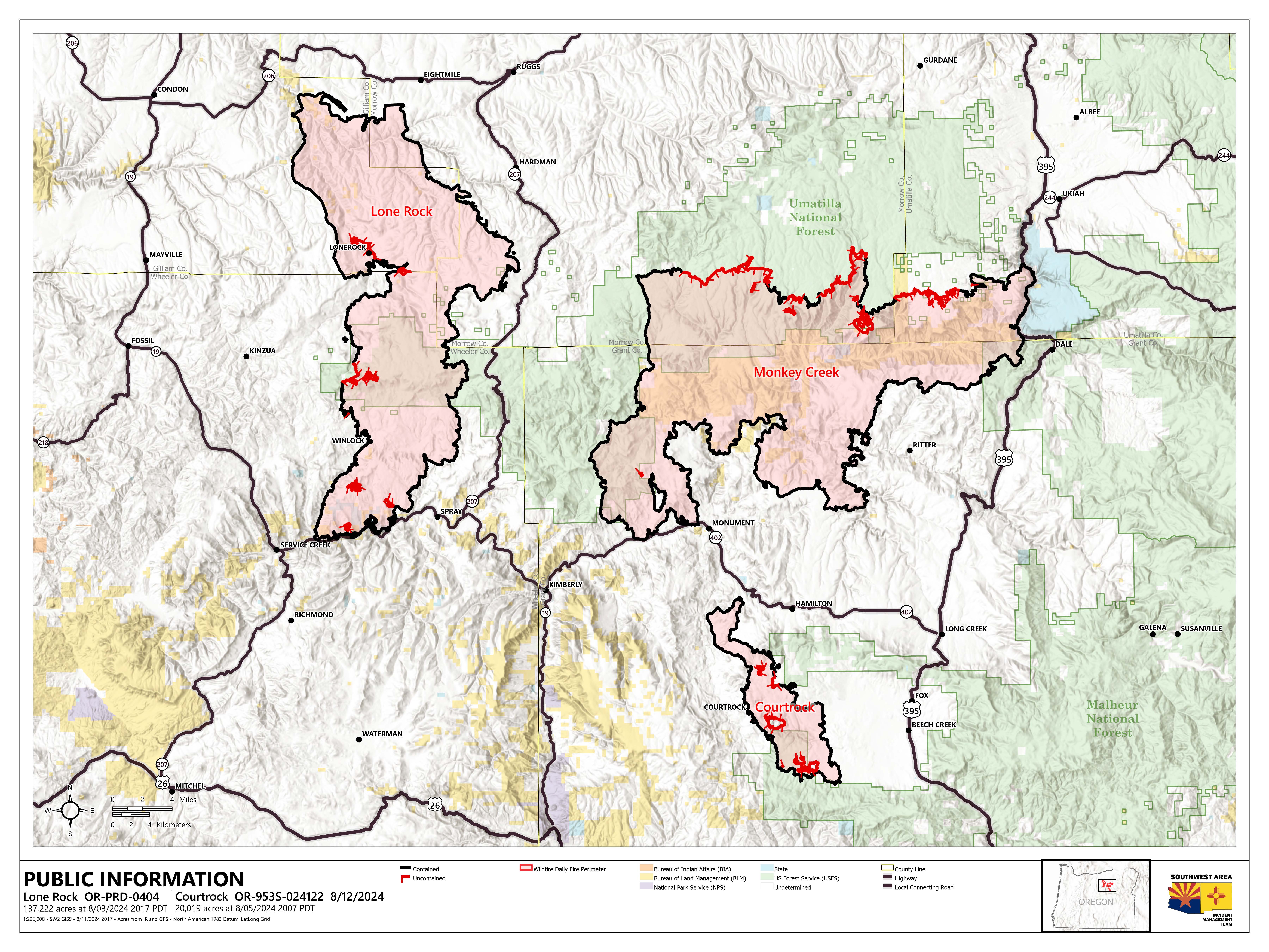
Public information map for the Lone Rock Fire, Monday, August 12, 2024
Size: 137,222
Containment: 98%
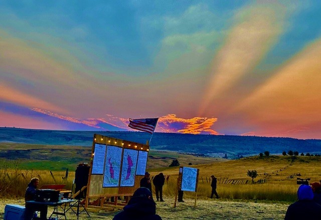
An American flag shining brightly off the glow of a beautiful Oregon sunrise. Taken at the Lone Rock and Courtrock fires operation briefing at 6 AM Friday, August 9th.
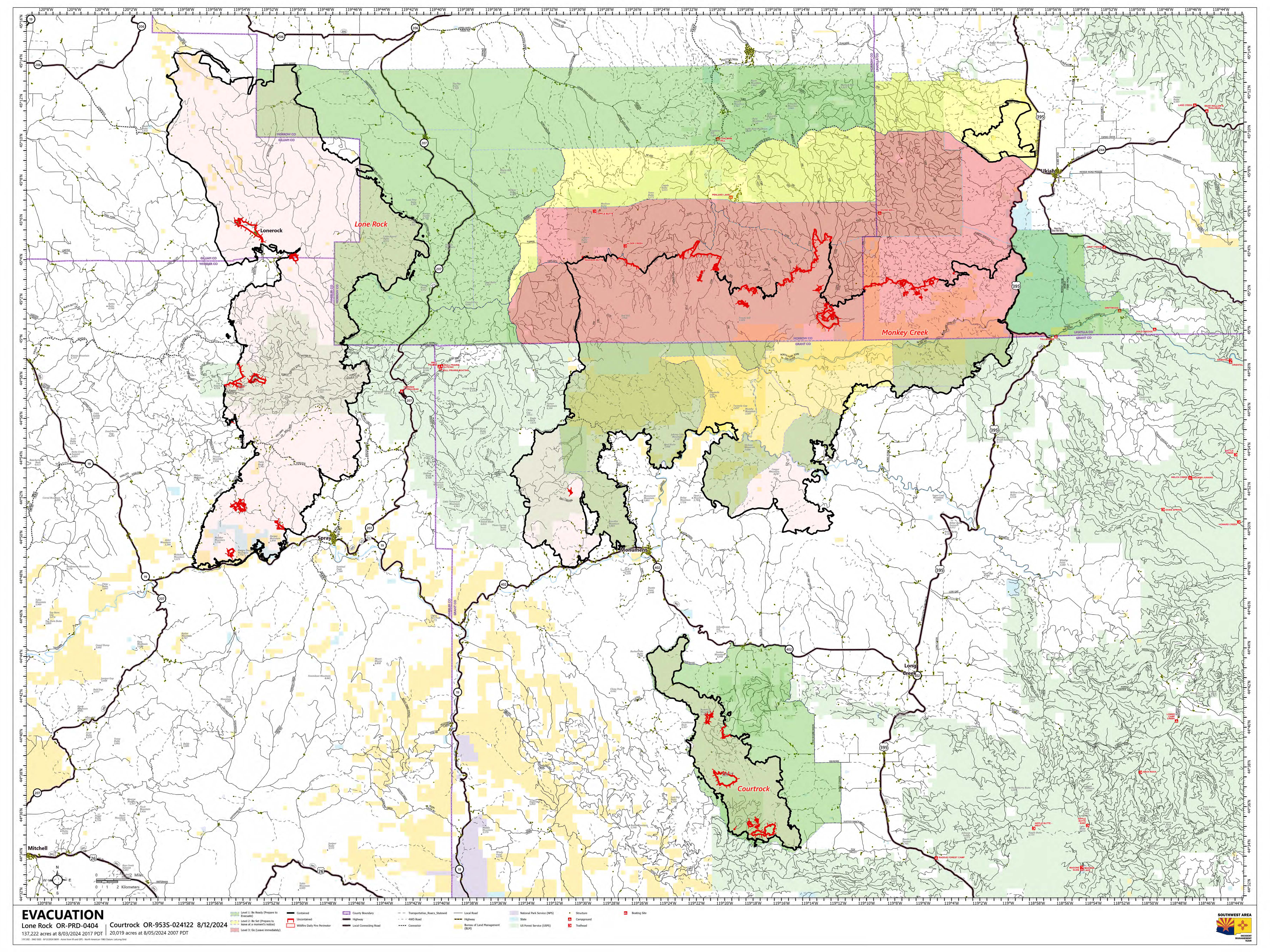
Evacuation Map for the areas surrounding and including the Lone Rock and Courtrock Fires. Most of the Lone Rock Fire has been downgraded out of evacuation. The remaining areas are at a Level 1 (Ready) as of this publication on Monday, August 12, 2024
The Lone Rock Fire began July 13, 2024, and is currently being managed under a full suppression strategy. Local ranchers and landowners along with local Rural Fire Protection Districts initially responded to the wildfire protecting structures and private property. Multiple Incident Management Teams have been working to contain the fire, protect structures, and other values at risk.
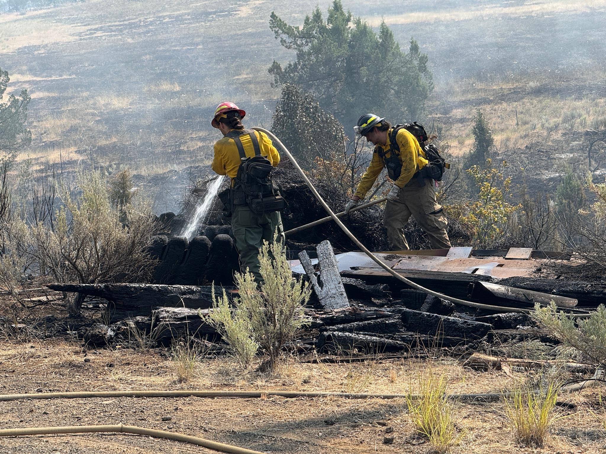
Firefighters continue to work on building containment lines and have begun mop-up operations in some locations of the fire. The fire footprint is within the following counties: Gilliam, Wheeler, Morrow and Grant. Hot, dry and windy weather initially hampered firefighter's ability to contain and control this wildfire as it grew to more than 130,000 acres. Wetter conditions allowed firefighters to gain containment and secured the northern end of the fire. Many structures were saved during this wildfire, though unfortunately some were lost.
Evacuation Information:
Only some Level 1 (ready) evacuations remain. Visit the interactive evacuation map for up-to-date changes to evacuation levels: Interactive Evacuation Map
Or visit local county websites for more information:
- For information on evacuations in Gilliam County, visit Gilliam County Sheriff's Office Facebook page.
- For information on evacuations in Wheeler County, visit Wheeler County Sheriff’s Office Facebook page.
- For information on evacuations in Morrow County, visit Morrow County Sheriff's Office Facebook page.
Shelters:
An evacuation center has been set up at the Wheeler High School (600 E B Street, Fossil, Ore.). A large animal shelter is available at the County Fairgrounds (720 E 3rd Street in Fossil, OR.).
Closures:
- road closure information,
- Umatilla National Forest Order Number 06-14-02-24-02 includes prohibitions within the Heppner Ranger District on the Umatilla National Forest.
- Bureau of Land Management Prineville District Office issued an Emergency Public Land Closure on BLM-managed lands along the main stem John Day River from Kimberly, Ore. to Dale, Ore., and along the North Fork John Day River from Kimberly, OR. to Dale, OR.
Prepare for Wildfires - a guide to prepare for fire season in Oregon and across the Western United States.
Air Quality
The Lone Rock Fire continues to emit smoke and impact air quality. Airnow.gov provides air quality information and an interactive map.
Please be responsible and help prevent wildfires firefighters by adhering to Oregon Department of Forestry Public Fire Restrictions and Umatilla National Forest Phase B Public Use Restrictions. Additional fire prevention tips are available at keeporegongreen.org
The Lone Rock Fire began July 13, 2024, and is currently being managed under a full suppression strategy. Local ranchers and landowners along with local Rural Fire Protection Districts initially responded to the wildfire protecting structures and private property. Multiple Incident Management Teams have been working to contain the fire, protect structures, and other values at risk.
Firefighters continue to work on building containment lines and have begun mop-up operations in some locations of the fire. The fire footprint is within the following counties: Gilliam, Wheeler, Morrow and Grant. Hot, dry and windy weather initially hampered firefighter's ability to contain and control this wildfire as it grew to more than 130,000 acres. Wetter conditions allowed firefighters to gain containment and secured the northern end of the fire. Many structures were saved during this wildfire, though unfortunately some were lost.
Evacuation Information:
Only some Level 1 (ready) evacuations remain. Visit the interactive evacuation map for up-to-date changes to evacuation levels: Interactive Evacuation Map
Or visit local county websites for more information:
- For information on evacuations in Gilliam County, visit Gilliam County Sheriff's Office Facebook page.
- For information on evacuations in Wheeler County, visit Wheeler County Sheriff’s Office Facebook page.
- For information on evacuations in Morrow County, visit Morrow County Sheriff's Office Facebook page.
Shelters:
An evacuation center has been set up at the Wheeler High School (600 E B Street, Fossil, Ore.). A large animal shelter is available at the County Fairgrounds (720 E 3rd Street in Fossil, OR.).
Closures:
- road closure information,
- Umatilla National Forest Order Number 06-14-02-24-02 includes prohibitions within the Heppner Ranger District on the Umatilla National Forest.
- Bureau of Land Management Prineville District Office issued an Emergency Public Land Closure on BLM-managed lands along the main stem John Day River from Kimberly, Ore. to Dale, Ore., and along the North Fork John Day River from Kimberly, OR. to Dale, OR.
Prepare for Wildfires - a guide to prepare for fire season in Oregon and across the Western United States.
Air Quality
The Lone Rock Fire continues to emit smoke and impact air quality. Airnow.gov provides air quality information and an interactive map.
Please be responsible and help prevent wildfires firefighters by adhering to Oregon Department of Forestry Public Fire Restrictions and Umatilla National Forest Phase B Public Use Restrictions. Additional fire prevention tips are available at keeporegongreen.org
| Current as of | Mon, 08/26/2024 - 19:30 |
|---|---|
| Incident Time Zone | America/Los_Angeles |
| Incident Type | Wildfire |
| Cause | Undetermined |
| Date of Origin | |
| Location | Lonerock stretching to west of HWY 207 and south to HWY 19 |
| Incident Commander | Southwest Area Incident Management Team 2, John Truett IC & Todd Abel Deputy IC |
| Incident Description | Lone Rock |
| Coordinates |
45° 10' 19.5'' Latitude
-119° 57' 41.4
'' Longitude
|
| Total Personnel: | 178 |
|---|---|
| Size | 137,222 Acres |
| Percent of Perimeter Contained | 98% |
| Estimated Containment Date | 08/15/2024 |
| Fuels Involved | Above average grass fuels exist at the northern and southern perimeters of the fire area. The continuous grass crop is cured and readily available for rapid ignition and elevated rates of spread with an ignition source and even moderate wind. Moving up in elevation towards the central area of the fire, grass fuels transition to grass with shrub juniper, shrublands, ponderosa pine on eastern/northern aspects, pine/grass savannas, and finally, at the highest elevations within the Umatilla National Forest, pine with mixed conifer.
|
| Significant Events | Isolated heat sources continue to slowly burn out on the interior of the fire. As these heat sources are surrounded by previously burned fuels, they are very unlikely to contribute to torching or ember production and are several hundred feet from any control lines, they do not constitute a hazard to containment.
|
| Planned Actions |
All lines are contained. The fire will be patrolled and if smoke is visible and the heat source will threaten the lines it will be mopped up. District READ is directing suppression repair. |
|---|---|
| Projected Incident Activity |
12 hours: Minimal smoldering in isolated hot spots well interior of control lines. 24 hours: A few isolated remaining individual hot spots well interior of control lines. Future growth is unlikely. 48 hours: Minimal detectable heat remaining and what isolated heat sources remain are interior and are very improbable of creating growing fire activity. 72 hours: Smoldering only. Anticipated after 72 hours: It is likely the majority of remaining isolated heat sources and scattered heat will have consumed all available fuel within further ignition proximity and self-extinguished. |
| Remarks |
Local landowners continue to actively participate in the suppression actions. Fire liaison officers continue to work directly with ranchers and include them in the operational planning process to obtain local knowledge and coordination. Evacuation levels have reduced. Mixed ownership creates some barriers for operations but the agencies of BLM, USFS & ODF continue to be in alignment and messaging. Additional information can be found on the Lone Rock Facebook page. Southwest Area Complex Incident Management Team 2 will transfer control of the Lone Rock Fire to a local agency Type 4 Organization as of 6 PM August 12th. |
| Weather Concerns | A weak series of disturbances are passing through the atmosphere in the vicinity of the fire area this weekend bringing a slight decrease in temperature and a marginal increased potential for isolated storms. The primary threat of the current weather pattern is the possibility of dry lightning and the continued dry receptive fuel bed throughout the area. |
|---|