
Incident Publication
Morning Update Frog Fire Friday 09 27 2024
Related Incident: Frog
Publication Type: News
Frog Fire Statistics
- Size: 3,112 acres
- Containment: 42%
- Total Personnel: 143
- Location: east of Clayton, ID
- Reported: September 7, 2024
- Cause: Lightning
For More Information
InciWeb: https://inciweb.wildfire.gov/incident-information/idstf-frog
Facebook: https://www.facebook.com/sawtoothnationalforest
Current Situation: On the Frog Fire, fire spread is limited by the discontinuous timber stands, which are broken up by rocky features and aspen stands. Rock screes are being used as natural barriers to contain the fire which has only grown 10 acres since September 13. The fire area is sheltered from the westerly winds by the high mountain ridges of the White Cloud Mountains.
Helicopters dropped buckets of water on the fire throughout the day yesterday, supporting fire crews working on the western edge of the fire perimeter. Some of the fire engines and equipment that have been patrolling the East Fork and Big Boulder Roads will be reassigned to the Wapiti due to the decreased potential for the Frog Fire to continue spreading to the north.
Evacuations: There are currently no evacuations related to the Frog Fire.
Closures: The area closure in place around the Frog Fire includes FS 667 (Big Boulder Creek Road) and Trail 047 where adjacent to the closure boundary. The closure excludes FS Roads 669 and 670 and Trail 682. Hunters and recreationalists should familiarize themselves with this closure information prior to entering the vicinity. Please reference the map and read the full closure description at https://inciweb.wildfire.gov/incident-closures/idstf-frog.
Morning Update Wapiti Fire Friday 09 27 2024
Related Incident:
Publication Type: News
Wapiti Fire Statistics
- Size: 125,508 acres
- Completion: 72%
- Total Personnel: 312
- Location: near Grandjean, ID
- Reported: July 24, 2024
- Cause: Lightning
For More Information
- InciWeb: https://inciweb.wildfire.gov/incident-information/idbof-wapiti-fire
- Facebook: https://www.facebook.com/wapitifireinfo2024
- Linktree: https://linktr.ee/WapitiFireInfo2024
- Interactive Map: https://tinyurl.com/WapitiFireInfoMap
Special Emphasis: As you head out for the weekend, check the status of roads, trails, and campgrounds for closures and potential traffic restrictions. Please respect all posted signage and obey any traffic control measures in place. Fire crews and heavy equipment will also be traveling the roads and highways. Fire managers and local forest officials are constantly evaluating the closures and will reduce and/or lift them only when conditions are safe enough to allow for public entry. The links below direct you to maps and information to help plan hunting and recreational activities. Collection of firewood within closure areas is also prohibited; any firewood collection in open areas must be done with a valid firewood permit. For questions on firewood collection on the Sawtooth National Forest, please contact the Stanley Ranger Station at 208.774.3000. The Burned Area Emergency Response (BAER) Team has arrived on the Wapiti Fire to begin assessments of the fire area and develop a plan for emergency stabilization to limit threats and damage from the effects of fire, such as erosion control.
Weather: Yesterday began with near-record high temperatures. And although it was breezy through the afternoon, fire behavior remained moderate on both the Wapiti and Frog Fires thanks to slightly higher humidity from the cloud cover. Beginning today, temperatures will climb again. The weekend will be unseasonably warm with clear skies expected. The pattern repeats Sunday when higher winds are again predicted, followed by warm and dry conditions.
Current Situation: Fire activity yesterday on the Wapiti Fire increased earlier in the day due to the warm morning temperatures. The activity was most prominent along the fire perimeter near Bull Trout Lake and Copper Mountain near Cape Horn. Helicopters dropped buckets of water on the flames to support fire crews working on the ground to dig fireline. The fire activity was not of significant concern for substantial growth; it was estimated at up to 5 acres last evening. Fire crews will continue to focus their suppression efforts in these locations through the weekend. Additional fire resources are arriving to support the fire suppression efforts and equipment is being reassigned from the Frog Fire to the Wapiti Fire to support the repair efforts.
The work to open the road to Grandjean is continuing at a good pace. Fire managers should soon have access to the valley then will evaluate the suppression repair needs and hazards. Fire-weakened trees that could fall on the road, buildings, or other infrastructure may be removed, and more equipment and supplies may be necessary to complete the repair work. Part of the work will also include developing a process and timeline for landowners to safely access their property.
Evacuations: Evacuation status for Stanley Zone 1 is currently at READY. Stanley Zones 2 – 5 and Kasino are no longer in an evacuation status. Sign up for Custer County CodeRED emergency notifications: text CUSTER to 99411 or enroll at https://public.coderedweb.com/CNE/BF28E45537FF.
All Boise County evacuation levels have been lifted; residents should remain alert for any change in conditions which could reinitiate an evacuation status. Sign up for Boise County Alert Sense emergency notifications at https://public.alertsense.com/SignUp/publicUser.aspx?regionid=1163.
For evacuation information on the Wapiti Fire, please see the Custer County Sheriff’s Facebook page, https://www.facebook.com/p/Custer-County-Sheriff-Idaho-61558947312289/, and the Boise County Sheriff’s Facebook page, https://www.facebook.com/boisecountysheriff/.
Closures: The Wapiti Fire area closure covers portions of the Sawtooth, Boise, and Salmon National Forests. Please reference the map and description at https://inciweb.wildfire.gov/incident-closures/idbof-wapiti-fire. Recreationalists and hunters should reference this map and obey all posted signage regarding the closure area and any related road, trail, and campground closures.
An interactive map for all closures on the Boise National Forest is found at https://experience.arcgis.com/experience/642380b0eb124c8cab6bd9ad3d7146ad/page/Overview/#data_s=id%3AdataSource_5-1888bd00a2c-layer-13-1888bd00b53-layer-16%3A82.
Firefighters at West Dolores Rim successfully completed 634 acres of prescribed burning09 26 2024
Related Incident:
Publication Type: Announcement
Great weather conditions today made it possible for firefighters to treat 634 acres on the West Dolores Rim Prescribed Burn project located 3 miles east of Egnar, Colorado. If conditions allow, firefighters will continue to burn the remaining 124 acres tomorrow in Unit 20A, located approx. 7.4 miles northeast of Dove Creek, CO.
Smoke might be visible on parts of Highway 141 and could settle in the Disappointment Valley overnight. While smoke may be visible in the burn area at times, most of the smoke will lift and dissipate during the warmest parts of the day. Expect visible smoke in the area for several days after each burn is completed as vegetation in the interior continues to smolder.
The BLM obtained smoke permits from the Colorado State Air Pollution Control Division, which identify atmospheric conditions under which the burns can be implemented. Prescribed fire smoke may affect your health. For more information, visit https://www.colorado.gov/pacific/cdphe/wood-smoke-and-health.
View the map and full announcement on the BLM website: https://www.blm.gov/.../sept-26-28-blm-conduct-prescribed....
For information on prescribed burns, visit the Southwest District BLM Prescribed Fire InciWeb page https://inciweb.nwcg.gov/incident/7852/ and follow us on Twitter https://twitter.com/SWD_Fire and Facebook http://www.facebook.com/BLMMontroseFireUnit.
_1727391375892.jpg?VersionId=heSTE03CjyMnR69JTzXz0NmrfAFMExVP)
Red Fire Daily Update for Thursday 09 26 2024
Related Incident: Red Fire
Publication Type: News
Willamette Complex South & Red Fire Update
Red, 208, Moss Mountain, Coffee Pot, Tire Mountain, McKinley Creek and Chalk Fires
Date: Thursday, September 26, 2024
Fire Causes: Lightning
Email: 2024.willamettecomplex@firenet.gov
Information Phone Line: 541-208-1742
Willamette Complex South: Total Personnel:495| Total Willamette Complex South Acres: 23,480
InciWeb: https://inciweb.wildfire.gov/incident-information/orwif-willamette-complex-fires-south
Facebook: https://www.facebook.com/WillametteComplexFires/
Red Fire: Total Personnel: 77 | Total Red Fire Acres: 1,916
InciWeb: https://inciweb.wildfire.gov/incident-information/ordef-red-fire
Facebook: https://www.facebook.com/2024RedFireOR/
Summary
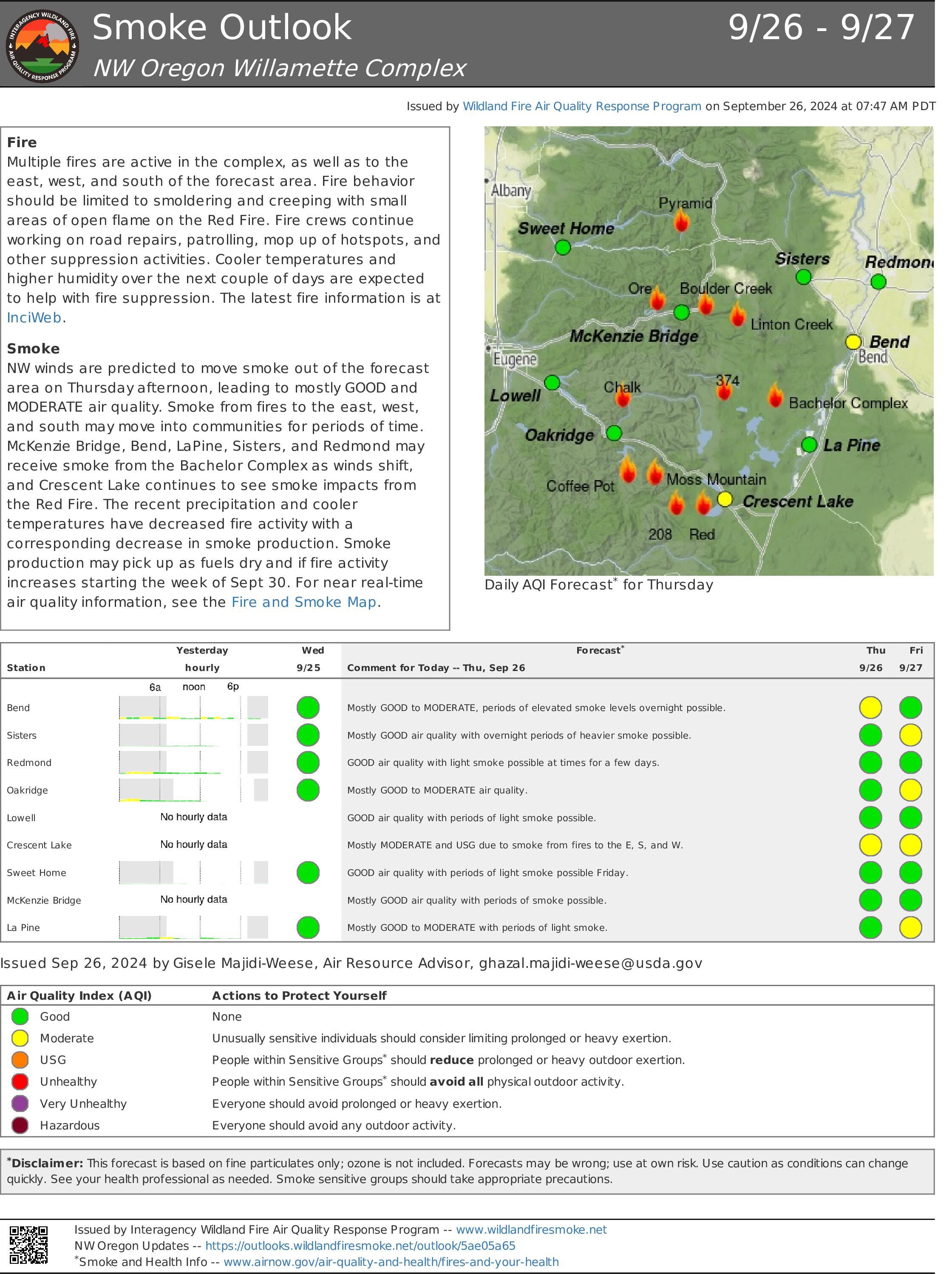
Personnel and equipment have shifted around the complex recently as conditions have continued to change. Over the last two days, firefighters focused on monitoring and suppression efforts, given the warmer, drier weather. The cold front that passed through the region yesterday brought cooler, moister weather, including light afternoon showers over much of the region. With that change, primary efforts have reverted to repairing forest roads and finalizing removal of woody debris from indirect firelines. Monitoring, road rehabilitation, and suppression repair continue on the Chalk, Coffee Pot, McKinley Creek and Tire Mountain fires, all still 100% contained. Road repair crews throughout the complex are emphasizing ditch and culvert clearing prior to final grading of the road surfaces. Some workers assigned to the Chalk and Coffee Pot fires may shift to the Roads Group for more efficient use of personnel. Overall, the Incident Management Team has focused recently on decreasing staff numbers to “right-size” operations.
Red Fire (1,916 acres, 11% containment)
Fire acreage grew 85 acres in the past two days because of warmer, drier weather. Firefighters anticipated this growth as the fire continues to slowly move down-slope toward Crescent Lake. Monitoring of fire activity remains a priority, particularly in the Whitefish Creek drainage and along Forest Service Road 60. A drone will aid in monitoring fire activity today.
208 Fire (9,045 acres, 4% containment)
Chipping operations continue on indirect lines surrounding the fire as crews near completion of this work. Firefighters continue frequent monitoring of the recently active northwest corner of the fire in the Swift Creek area.
Moss Mountain Fire (2,186 acres, 10% containment)
Fuel reduction around the Wolf Mountain Communications site paused yesterday because of stormy weather, and firefighters shifted to road repair work in safer locations. With milder weather expected, they will resume work around the communications infrastructure for the next few days. Road repair crews will soon put the finishing touches on the 23 Road. A drone may assist with monitoring of fire activity today.
Weather and Fire Behavior
Precipitation yesterday was more widespread than anticipated, but the most rain recorded on the complex amounted to only two-tenths of an inch. With the passage of the front, milder fall-like conditions resume. Clouds will linger this morning with a 5% chance of additional precipitation. High pressure settling in today should usher in clear skies with highs in the upper 60s to low 70s and lower relative humidity.
Closures, Fire Restrictions, and Evacuation
- For closure information, visit: https://tinyurl.com/RedFireClosures2024 & https://tinyurl.com/WillFireClosures2024.
- For fire restrictions, visit: https://tinyurl.com/DesFireRestrictions2024 & https://tinyurl.com/WillFireRestrictions2024.
- The Level 1 – BE READY to Evacuate notice remains in effect for the Red Fire. For more information or to sign up for alerts, visit: www.klamathcounty.org/300/emergency-management.
_0.jpg?VersionId=0PhugLQTLI4x9BA9owf2SzGEJbQkQZBn)
Willamette Complex South Daily Update for Thursday 09 26 2024
Related Incident: Willamette Complex Fires - South
Publication Type: News
Willamette Complex South & Red Fire Update
Red, 208, Moss Mountain, Coffee Pot, Tire Mountain, McKinley Creek and Chalk Fires
Date: Thursday, September 26, 2024
Fire Causes: Lightning
Email: 2024.willamettecomplex@firenet.gov
Information Phone Line: 541-208-1742
Willamette Complex South: Total Personnel:495| Total Willamette Complex South Acres: 23,480
InciWeb: https://inciweb.wildfire.gov/incident-information/orwif-willamette-complex-fires-south
Facebook: https://www.facebook.com/WillametteComplexFires/
Red Fire: Total Personnel: 77 | Total Red Fire Acres: 1,916
InciWeb: https://inciweb.wildfire.gov/incident-information/ordef-red-fire
Facebook: https://www.facebook.com/2024RedFireOR/
Summary
Personnel and equipment have shifted around the complex recently as conditions have continued to change. Over the last two days, firefighters focused on monitoring and suppression efforts, given the warmer, drier weather. The cold front that passed through the region yesterday brought cooler, moister weather, including light afternoon showers over much of the region. With that change, primary efforts have reverted to repairing forest roads and finalizing removal of woody debris from indirect firelines. Monitoring, road rehabilitation, and suppression repair continue on the Chalk, Coffee Pot, McKinley Creek and Tire Mountain fires, all still 100% contained. Road repair crews throughout the complex are emphasizing ditch and culvert clearing prior to final grading of the road surfaces. Some workers assigned to the Chalk and Coffee Pot fires may shift to the Roads Group for more efficient use of personnel. Overall, the Incident Management Team has focused recently on decreasing staff numbers to “right-size” operations.
Red Fire (1,916 acres, 11% containment)
Fire acreage grew 85 acres in the past two days because of warmer, drier weather. Firefighters anticipated this growth as the fire continues to slowly move down-slope toward Crescent Lake. Monitoring of fire activity remains a priority, particularly in the Whitefish Creek drainage and along Forest Service Road 60. A drone will aid in monitoring fire activity today.
208 Fire (9,045 acres, 4% containment)
Chipping operations continue on indirect lines surrounding the fire as crews near completion of this work. Firefighters continue frequent monitoring of the recently active northwest corner of the fire in the Swift Creek area.
Moss Mountain Fire (2,186 acres, 10% containment)
Fuel reduction around the Wolf Mountain Communications site paused yesterday because of stormy weather, and firefighters shifted to road repair work in safer locations. With milder weather expected, they will resume work around the communications infrastructure for the next few days. Road repair crews will soon put the finishing touches on the 23 Road. A drone may assist with monitoring of fire activity today.
Weather and Fire Behavior
Precipitation yesterday was more widespread than anticipated, but the most rain recorded on the complex amounted to only two-tenths of an inch. With the passage of the front, milder fall-like conditions resume. Clouds will linger this morning with a 5% chance of additional precipitation. High pressure settling in today should usher in clear skies with highs in the upper 60s to low 70s and lower relative humidity.
Closures, Fire Restrictions, and Evacuation
- For closure information, visit: https://tinyurl.com/RedFireClosures2024 & https://tinyurl.com/WillFireClosures2024.
- For fire restrictions, visit: https://tinyurl.com/DesFireRestrictions2024 & https://tinyurl.com/WillFireRestrictions2024.
- The Level 1 – BE READY to Evacuate notice remains in effect for the Red Fire. For more information or to sign up for alerts, visit: www.klamathcounty.org/300/emergency-management.
.jpg?VersionId=j_TUPL9A4PloeqAoVyx3EZi.zmx13g0d)
Airport Fire Incident Update 09 26 2024
Related Incident:
Publication Type: News
Location: Trabuco Canyon, CA
Personnel: 265
Start date: 09/09/24 1:00 p.m.
Cause: Human
Size: 23,519
Percent contained: 95%
Progress continues on the Airport Fire. Handcrews engaged on the northern end of the fire. This is the area with the most deep-seated heat and difficult terrain to access. Hotshot crews were able to continue mitigating heat signatures from this section and reinforced existing firelines and fuelbreaks. They are also patrolling and monitoring all divisions of the fire, making sure no additional heat remains. Air resources are also flying missions, backhauling equipment, and providing aerial reconnaissance to crews on the ground. They are also employing UAS drones outfitted with infrared sensors to identify any points of heat that could threaten the containment lines. These drones will be active in these same areas over the next few days.
Additional resources are engaged along the fire’s perimeter, working with the Burned Area Emergency Response (BAER) team, assessing the potential for watershed emergencies that could develop during the rainy season, such as flooding or mudslides. Fire suppression repair is also ongoing, with crews working hard to minimize the impacts on the land from the recent activity.
Over the next several days, additional crews will be working in Trabuco Canyon, felling hazardous trees that have been identified. These are trees that were too heavily damaged by the fire to continue standing, or pose a serious threat of falling near roads, structures, or people.
Hikers and mountain bikers have been observed on some of the trails within the fire’s footprint. We would like to remind everyone that a closure order is in effect for the Trabuco Ranger District of the Cleveland National Forest. Please do not enter the closure area or recreate on any of the firelines constructed for the incident. https://www.fs.usda.gov/alerts/cleveland/alerts-notices/?aid=90727
Southern California Edison Electric Utility Company continues to replace damaged power poles and lines in the Lake Elsinore area and will be using helicopters to transport and place these poles. Operations will be scheduled during times of minimal highway use. However, all motorists should be aware that traffic delays can occasionally occur for extended periods. Please plan accordingly.
AIR QUALITY:
Visit AirNow.gov for information and actions you can take to protect yourself and loved ones.
ROAD CLOSURES:
Hard road closures are as follows:
- Trabuco Creek Road
- Maple Springs Road
- North Main Divide Road at Ortega Highway
- Long Canyon Road at Ortega Highway
EVACUATIONS:
All Evacuation orders have been lifted.
CLOSURES:
The Cleveland National Forest has a temporary closure of the Trabuco Ranger District. This closure prohibits going into or, being upon any National Forest System lands, roads, and trails within the boundaries of the Trabuco Ranger District. The closure will be in effect from September 18, 2024 until September 17, 2025, to provide for public health and safety concerns related to the Airport Fire. To view the Forest Orders and Maps, visit our website at: https://www.fs.usda.gov/alerts/cleveland/alerts-notices/?aid=90727 .
FIRE RESTRICTIONS:
There is a Temporary Flight Restriction in effect. Updates on the locations and status of this TFR can be accessed at https://tfr.faa.gov/tfr2/list.html.
Black Eagle Daily Update 9262024 09 26 2024
Related Incident:
Publication Type: News
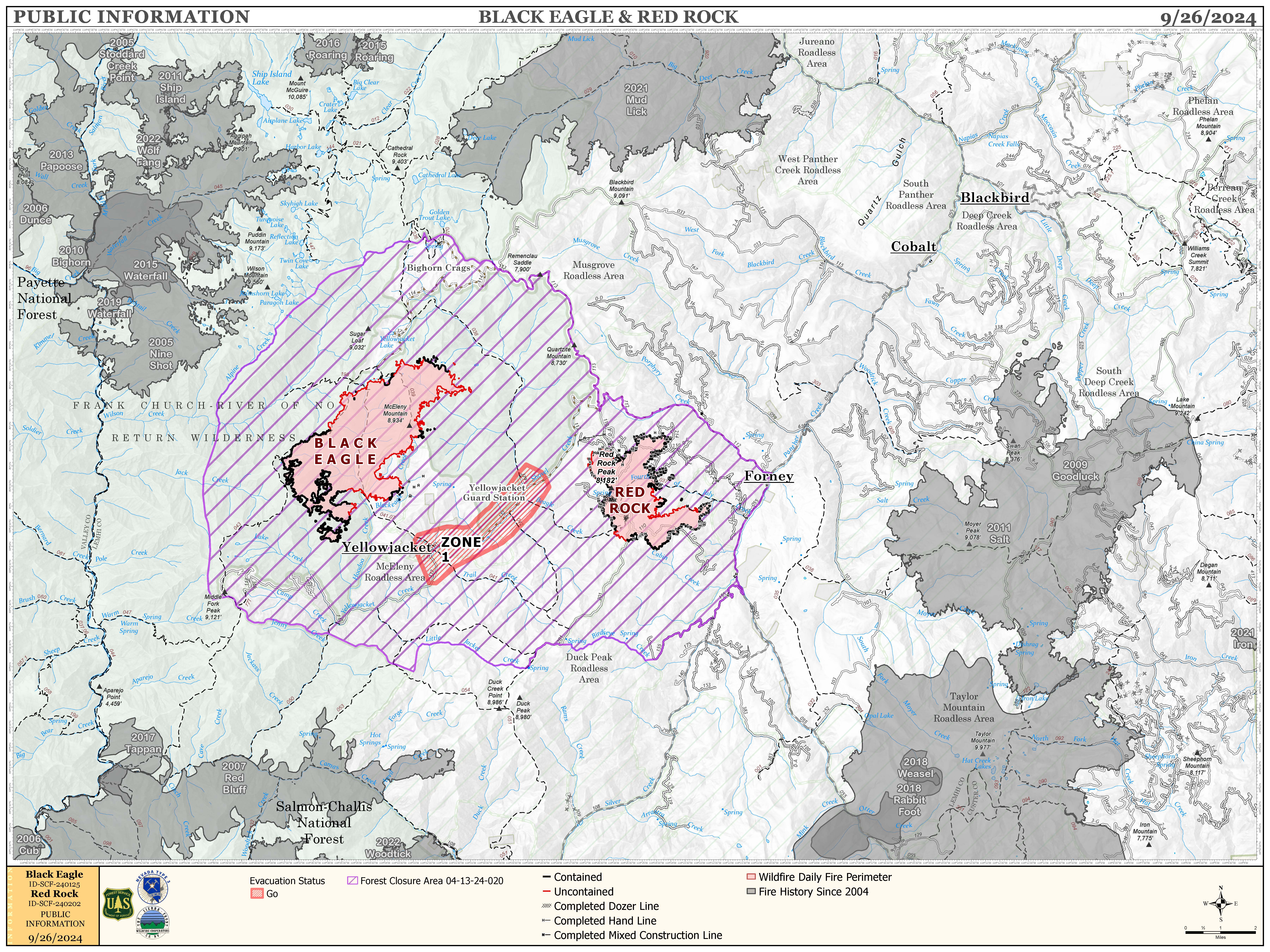
CA Team 4 has transitioned command to Sierra Front / Nevada Team 5.
FIRE ACTIVITY:
The Red Rock Fire is at 3,141 acres and 73% containment.
Yesterday, the area around Red Rock Peak experienced increased fire activity as southern winds pushed the fire northeast. With support from air support, firefighters made significant progress in constructing containment lines around the northwest corner of the fire. In other areas, crews continued to establish handlines along the remaining uncontained sections of the perimeter, including some relatively inactive parts on the southern and eastern flanks.
Today, firefighting units will focus on mopping up, reinforcing, and extending existing handlines, particularly in the active northwest corner. They will also begin laying hoselines in this area to address any hot spots. Throughout the day, air support will continue to provide crucial assistance to ground crews.
The Black Eagle Fire is at 6,494 acres and 8% containment.
Yesterday, the northeast section of the Black Eagle Fire showed increased activity within the wilderness and the fire area. However, progress is being made in containing the southeast corner of the fire. Teams, supported by aircraft, are constructing direct lines and mopping up on both sides of Black Eagle Creek.
Today, crews will keep focusing on the Black Eagle Creek area, and aircraft will be deployed to assist with the northeast section of the fire.
WEATHER:
Yesterday was warmer and drier than expected, and today is likely to follow that trend with predicted temperatures in the low 70’s and relative humidity possibly dropping to 18%. Although winds coming from the southwest will be around 10mph during the day, we may see gusts of up to 25 mph in the afternoon.
FIRE BEHAVIOR:
Today’s weather is expected to bring some of the most challenging fire behavior we’ve encountered in a while. Although the handlines established by firefighters should help control the situation, there will still be pockets of the fire area filled with heavy dead and down fuels that may flare up. As usual, the northeast section of the Black Eagle Fire and the northwest section of the Red Rock Fire will likely see particularly intense activity. In the afternoon, this heightened fire behavior may restrict firefighters’ ability to directly engage the fire’s edge, increasing our reliance on air support for containment efforts.
FOREST CLOSURES: For forest closure information please go to: https://www.fs.usda.gov/alerts/scnf/alerts-notices
EVACUATIONS: For evacuation information in Lemhi County regarding these fires please go to: Emergency Management Department | Lemhi County, ID (lemhicountyidaho.org).
Red Rock Daily Update 9262024 09 26 2024
Related Incident:
Publication Type: News
CA Team 4 has transitioned command to Sierra Front / Nevada Team 5.
FIRE ACTIVITY:
The Red Rock Fire is at 3,141 acres and 73% containment.
Yesterday, the area around Red Rock Peak experienced increased fire activity as southern winds pushed the fire northeast. With support from air support, firefighters made significant progress in constructing containment lines around the northwest corner of the fire. In other areas, crews continued to establish handlines along the remaining uncontained sections of the perimeter, including some relatively inactive parts on the southern and eastern flanks.
Today, firefighting units will focus on mopping up, reinforcing, and extending existing handlines, particularly in the active northwest corner. They will also begin laying hoselines in this area to address any hot spots. Throughout the day, air support will continue to provide crucial assistance to ground crews.
The Black Eagle Fire is at 6,494 acres and 8% containment.
Yesterday, the northeast section of the Black Eagle Fire showed increased activity within the wilderness and the fire area. However, progress is being made in containing the southeast corner of the fire. Teams, supported by aircraft, are constructing direct lines and mopping up on both sides of Black Eagle Creek.
Today, crews will keep focusing on the Black Eagle Creek area, and aircraft will be deployed to assist with the northeast section of the fire.
WEATHER:
Yesterday was warmer and drier than expected, and today is likely to follow that trend with predicted temperatures in the low 70’s and relative humidity possibly dropping to 18%. Although winds coming from the southwest will be around 10mph during the day, we may see gusts of up to 25 mph in the afternoon.
FIRE BEHAVIOR:
Today’s weather is expected to bring some of the most challenging fire behavior we’ve encountered in a while. Although the handlines established by firefighters should help control the situation, there will still be pockets of the fire area filled with heavy dead and down fuels that may flare up. As usual, the northeast section of the Black Eagle Fire and the northwest section of the Red Rock Fire will likely see particularly intense activity. In the afternoon, this heightened fire behavior may restrict firefighters’ ability to directly engage the fire’s edge, increasing our reliance on air support for containment efforts.
FOREST CLOSURES: For forest closure information please go to: https://www.fs.usda.gov/alerts/scnf/alerts-notices
EVACUATIONS: For evacuation information in Lemhi County regarding these fires please go to: Emergency Management Department | Lemhi County, ID (lemhicountyidaho.org).
West Fire Daily Update 09 26 2024
Related Incident: 2024 - West Fire - TNF
Publication Type: News
UPDATE: West Fire, Payson Ranger District
September 26, 2024
Size: 15,058 acres Start Date: August 28, 2024
Cause: Lightning Location: Payson Ranger District, Arizona
Containment: 51% Fuels: Ponderosa pine, mixed conifer, chaparral
Total personnel: 153
Operations: Yesterday fire crews successfully hand-ignited a twenty-acre section on the southern edge of the fire to secure fire line in that area. In the interior, fire consumed dead and down fuel in a natural way clearing the forest floor from buildups of vegetation that can contribute to catastrophic future fires, helping to protect the communities of Pine and Geronimo Estates. Today, crews will burn and monitor brush piles east of the Pine Trailhead to further secure the line as opportunity allows. More containment is expected near Geronimo Estates in the next day or two. The fire team plans to assess current evacuation levels today for affected communities of Pine and Geronimo Estates.
Weather: Today, sunny warm and dry conditions continue with a high temper of 92 degrees. 0% chance of precipitation with humidity in the 18% range. Winds E around 9 mph, switching S in the pm. Tonight: Clear with a low around 65, winds W around 7 mph, NE in late evening.
Safety: The health and safety of firefighters and the public are always a priority. Members of the public are asked to avoid the fire area and use caution around fire equipment on the roads.
Smoke: Smoke from the West fire may be visible as interior fuel continues to dry and burn, decreasing as the week wears on. Expect concentrations in low lying areas near the fire perimeter in the mornings, which will clear out as air warms during the day. Smoke-sensitive individuals and people with respiratory problems or heart disease are encouraged to take precautionary measures. Learn more about smoke impacts on the Arizona Department of Environmental Quality website.
Closures: The Tonto National Forest has issued a closure for land surrounding the West fire. This includes the Pine Trailhead. https://inciweb.wildfire.gov/incident-publication/aztnf-2024-west-fire-tnf/us-forest-service-closure-order-for-west-fire-09-04-2024
Evacuations: Pine residents on the east side of SR 87 and east of North Pine Creek Canyon Road are in SET status. Geronimo Estates residents near the West Fire are in SET status. For information on evacuation status, visit https://nifc.maps.arcgis.com/apps/instant/sidebar/index.html?appid=9bf2ca222ee74f8697bc670ae9c2531a To receive emergency notifications from Gila County, visit https://gilacountyaz.genasys.com/portal/en
For the latest news and information about the Tonto National Forest, follow along on Facebook @TontoNationalForest, ‘X’ (formerly Twitter) @TontoForest or Instagram @tontonationalforest and on the Tonto National Forest website: https://www.fs.usda.gov/tonto
Lava Fire Daily Update 92524 09 25 2024
Related Incident:
Publication Type: News
Rocky Mountain Area Complex Incident Management Team Two assumed command of the Lava Fire at 6 a.m. today.
Current Situation:
- The Lava Fire is 67% contained at 97,773 acres, with 660 personnel assigned.
- Suppression repair is and continues to be planned around the fire to mitigate future erosion and repair damage caused by firefighting efforts.
- Divisions Kilo and November remain in mop-up and patrol status. Unmanned Aircraft System (UAS), also known as drones, continue to monitor the area to identify hot spots.
- In Division Uniform, crews continue to mop-up around the slop that extended over the 653 road.
- In Division Foxtrot in the Anderson Creek Drainage, the Sawtooth Hotshots are putting in fire line to secure the uncontained fire edge and reduce the risk of the fire making a run to the northeast.
Weather: While yesterday was sunny, with minimal wind, and relatively humidity around 30%; today, it is anticipated to be hotter, dryer, windier. Today will likely be the hottest, dryest, and windiest day since the percipiation last week. Temperatures are expected to be in the 70s with 20 mph winds and relative humidity decreasing to around 23%. There are no anticipated thunderstorms or irratic weather for today into tomorrow.
Evacuations: A Level 1 “READY” notice remains for residents south of South Grays Creek, along Little Weiser River Road in Indian Valley, North of South Grays Creek Road to Highway 95, and the Mesa Area. Valley County Sheriff’s Office has removed Zones 2 & 3 from LEVEL 1 “READY” status. Zones 4 – 6 remain in a LEVEL 1 “READY” Evacuation notice.
Closures: The Boise and Payette National Forests implemented a joint Lava Fire Area, Road, and Trail Closure for public and firefighter safety. The southern portion of this closure area follows roads 601 (which remains closed) and 644 (which remains open). The northern boundary follows a portion of the Payette National Forest’s Road 186 (open) and crosses over to the Boise National Forest just south of trail 116. Snowbank Road (446) and Sage Hen Reservoir area remain closed, French Creek Campground remains open. This closure adjustment remains in effect since September 19, 2024.
Gem County Road and Bridge issued the following road closures: Third Fork Road at Nesbitt Lane, Second Fork Road at Nesbitt Lane, and Nesbitt Lane. The Sweet-Ola Highway is closed at the High Valley intersection in Ola. Please be advised that the Gem County Sheriff’s Office is staffing the road closure check points.
Temporary Flight Restrictions: A temporary flight restriction (TFR) has been updated. View a map of the TFR and details at https://tfr.faa.gov/save_pages/detail_4_8199.html. Fire aviation response is halted or delayed if an unauthorized aircraft enters the TFR. Temporary flight restrictions also apply to unmanned aircraft systems or drones. If you fly, we can’t! Learn more about how to use drones safely and responsibly at Home - Know BeforeYou Fly.
Fire Info Phone: 208-708-5003 Hours: 7:00 a.m. to 7:00 p.m. Email: 2024.Lava@firenet.gov .
Facebook:@LavaFire Inciweb: inciweb.wildfire.gov/incident-information/idbof-lava-fire