
Incident Publication
Red Rock Daily Update 9262024 09 26 2024
Related Incident:
Publication Type: News
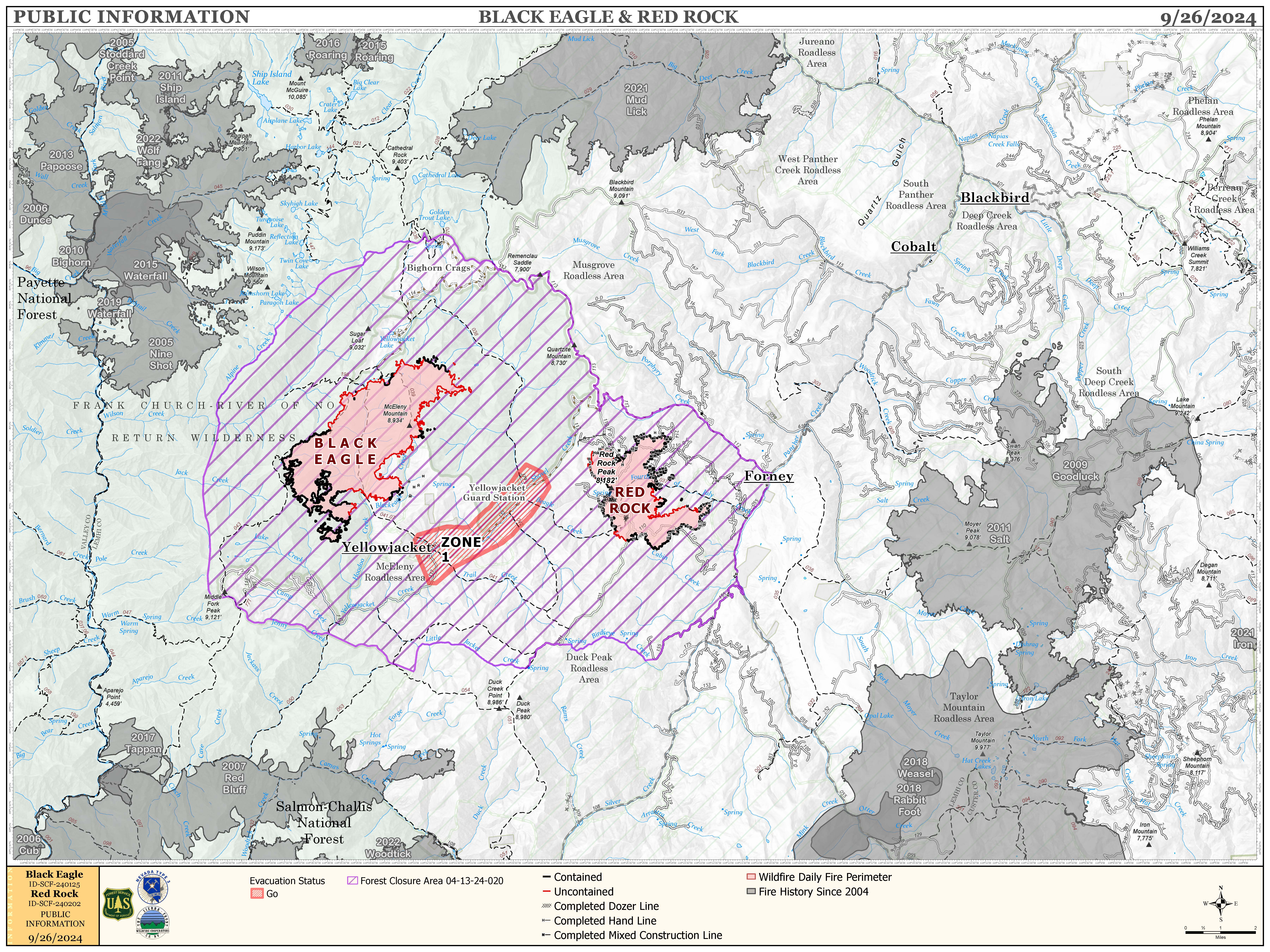
CA Team 4 has transitioned command to Sierra Front / Nevada Team 5.
FIRE ACTIVITY:
The Red Rock Fire is at 3,141 acres and 73% containment.
Yesterday, the area around Red Rock Peak experienced increased fire activity as southern winds pushed the fire northeast. With support from air support, firefighters made significant progress in constructing containment lines around the northwest corner of the fire. In other areas, crews continued to establish handlines along the remaining uncontained sections of the perimeter, including some relatively inactive parts on the southern and eastern flanks.
Today, firefighting units will focus on mopping up, reinforcing, and extending existing handlines, particularly in the active northwest corner. They will also begin laying hoselines in this area to address any hot spots. Throughout the day, air support will continue to provide crucial assistance to ground crews.
The Black Eagle Fire is at 6,494 acres and 8% containment.
Yesterday, the northeast section of the Black Eagle Fire showed increased activity within the wilderness and the fire area. However, progress is being made in containing the southeast corner of the fire. Teams, supported by aircraft, are constructing direct lines and mopping up on both sides of Black Eagle Creek.
Today, crews will keep focusing on the Black Eagle Creek area, and aircraft will be deployed to assist with the northeast section of the fire.
WEATHER:
Yesterday was warmer and drier than expected, and today is likely to follow that trend with predicted temperatures in the low 70’s and relative humidity possibly dropping to 18%. Although winds coming from the southwest will be around 10mph during the day, we may see gusts of up to 25 mph in the afternoon.
FIRE BEHAVIOR:
Today’s weather is expected to bring some of the most challenging fire behavior we’ve encountered in a while. Although the handlines established by firefighters should help control the situation, there will still be pockets of the fire area filled with heavy dead and down fuels that may flare up. As usual, the northeast section of the Black Eagle Fire and the northwest section of the Red Rock Fire will likely see particularly intense activity. In the afternoon, this heightened fire behavior may restrict firefighters’ ability to directly engage the fire’s edge, increasing our reliance on air support for containment efforts.
FOREST CLOSURES: For forest closure information please go to: https://www.fs.usda.gov/alerts/scnf/alerts-notices
EVACUATIONS: For evacuation information in Lemhi County regarding these fires please go to: Emergency Management Department | Lemhi County, ID (lemhicountyidaho.org).
West Fire Daily Update 09 26 2024
Related Incident: 2024 - West Fire - TNF
Publication Type: News
UPDATE: West Fire, Payson Ranger District
September 26, 2024
Size: 15,058 acres Start Date: August 28, 2024
Cause: Lightning Location: Payson Ranger District, Arizona
Containment: 51% Fuels: Ponderosa pine, mixed conifer, chaparral
Total personnel: 153
Operations: Yesterday fire crews successfully hand-ignited a twenty-acre section on the southern edge of the fire to secure fire line in that area. In the interior, fire consumed dead and down fuel in a natural way clearing the forest floor from buildups of vegetation that can contribute to catastrophic future fires, helping to protect the communities of Pine and Geronimo Estates. Today, crews will burn and monitor brush piles east of the Pine Trailhead to further secure the line as opportunity allows. More containment is expected near Geronimo Estates in the next day or two. The fire team plans to assess current evacuation levels today for affected communities of Pine and Geronimo Estates.
Weather: Today, sunny warm and dry conditions continue with a high temper of 92 degrees. 0% chance of precipitation with humidity in the 18% range. Winds E around 9 mph, switching S in the pm. Tonight: Clear with a low around 65, winds W around 7 mph, NE in late evening.
Safety: The health and safety of firefighters and the public are always a priority. Members of the public are asked to avoid the fire area and use caution around fire equipment on the roads.
Smoke: Smoke from the West fire may be visible as interior fuel continues to dry and burn, decreasing as the week wears on. Expect concentrations in low lying areas near the fire perimeter in the mornings, which will clear out as air warms during the day. Smoke-sensitive individuals and people with respiratory problems or heart disease are encouraged to take precautionary measures. Learn more about smoke impacts on the Arizona Department of Environmental Quality website.
Closures: The Tonto National Forest has issued a closure for land surrounding the West fire. This includes the Pine Trailhead. https://inciweb.wildfire.gov/incident-publication/aztnf-2024-west-fire-tnf/us-forest-service-closure-order-for-west-fire-09-04-2024
Evacuations: Pine residents on the east side of SR 87 and east of North Pine Creek Canyon Road are in SET status. Geronimo Estates residents near the West Fire are in SET status. For information on evacuation status, visit https://nifc.maps.arcgis.com/apps/instant/sidebar/index.html?appid=9bf2ca222ee74f8697bc670ae9c2531a To receive emergency notifications from Gila County, visit https://gilacountyaz.genasys.com/portal/en
For the latest news and information about the Tonto National Forest, follow along on Facebook @TontoNationalForest, ‘X’ (formerly Twitter) @TontoForest or Instagram @tontonationalforest and on the Tonto National Forest website: https://www.fs.usda.gov/tonto
Lava Fire Daily Update 92524 09 25 2024
Related Incident:
Publication Type: News
Rocky Mountain Area Complex Incident Management Team Two assumed command of the Lava Fire at 6 a.m. today.
Current Situation:
- The Lava Fire is 67% contained at 97,773 acres, with 660 personnel assigned.
- Suppression repair is and continues to be planned around the fire to mitigate future erosion and repair damage caused by firefighting efforts.
- Divisions Kilo and November remain in mop-up and patrol status. Unmanned Aircraft System (UAS), also known as drones, continue to monitor the area to identify hot spots.
- In Division Uniform, crews continue to mop-up around the slop that extended over the 653 road.
- In Division Foxtrot in the Anderson Creek Drainage, the Sawtooth Hotshots are putting in fire line to secure the uncontained fire edge and reduce the risk of the fire making a run to the northeast.
Weather: While yesterday was sunny, with minimal wind, and relatively humidity around 30%; today, it is anticipated to be hotter, dryer, windier. Today will likely be the hottest, dryest, and windiest day since the percipiation last week. Temperatures are expected to be in the 70s with 20 mph winds and relative humidity decreasing to around 23%. There are no anticipated thunderstorms or irratic weather for today into tomorrow.
Evacuations: A Level 1 “READY” notice remains for residents south of South Grays Creek, along Little Weiser River Road in Indian Valley, North of South Grays Creek Road to Highway 95, and the Mesa Area. Valley County Sheriff’s Office has removed Zones 2 & 3 from LEVEL 1 “READY” status. Zones 4 – 6 remain in a LEVEL 1 “READY” Evacuation notice.
Closures: The Boise and Payette National Forests implemented a joint Lava Fire Area, Road, and Trail Closure for public and firefighter safety. The southern portion of this closure area follows roads 601 (which remains closed) and 644 (which remains open). The northern boundary follows a portion of the Payette National Forest’s Road 186 (open) and crosses over to the Boise National Forest just south of trail 116. Snowbank Road (446) and Sage Hen Reservoir area remain closed, French Creek Campground remains open. This closure adjustment remains in effect since September 19, 2024.
Gem County Road and Bridge issued the following road closures: Third Fork Road at Nesbitt Lane, Second Fork Road at Nesbitt Lane, and Nesbitt Lane. The Sweet-Ola Highway is closed at the High Valley intersection in Ola. Please be advised that the Gem County Sheriff’s Office is staffing the road closure check points.
Temporary Flight Restrictions: A temporary flight restriction (TFR) has been updated. View a map of the TFR and details at https://tfr.faa.gov/save_pages/detail_4_8199.html. Fire aviation response is halted or delayed if an unauthorized aircraft enters the TFR. Temporary flight restrictions also apply to unmanned aircraft systems or drones. If you fly, we can’t! Learn more about how to use drones safely and responsibly at Home - Know BeforeYou Fly.
Fire Info Phone: 208-708-5003 Hours: 7:00 a.m. to 7:00 p.m. Email: 2024.Lava@firenet.gov .
Facebook:@LavaFire Inciweb: inciweb.wildfire.gov/incident-information/idbof-lava-fire
Bridge Fire Daily Update 09 26 2024
Related Incident: Bridge Fire
Publication Type: News
Start Date: September 8, 2024, at 2:12 p.m.
Location: Sheep Mountain Wilderness, San Gabriel Mountains National Monument
Fire Size: 54,878 acres
Percent Contained: 93 %
Cause: Under investigation
Personnel: 377
Injuries: 8
Structures Damaged: 17
Structures Destroyed: 81
CURRENT SITUATION:
**THIS WILL BE THE FINAL DAILY UPDATE FOR THE BRIDGE FIRE**
CURRENT SITUATION: Hot, dry weather continues today and will likely cause some unburned pockets of fuel to flare up. When this happens, smoke may be visible in the fire interior. Firefighters will continue mopping up, investigating smoke, and extinguishing isolated heat sources. Hazardous trees will also be removed to improve public and crew safety.
A Forest Closure Order is in effect for portions of the Angeles National Forest. Some recreation areas are closed to public use. The Bridge Fire area forest closure order is available at Angeles National Forest offices and online at: https://www.fs.usda.gov/angeles
Damage inspection teams completed their inspections. Residents affected by the Bridge Fire can find information on the following websites:
For San Bernardino County: prepare.sbcounty.gov/bridge-fire/
For Los Angeles County: recovery.lacounty.gov/bridgefire/
For emergency alerts, please register here:
- Los Angeles County: https://ready.lacounty.gov/emergency-notifications/
- San Bernardino County: https://wp.sbcounty.gov/sheriff/alerts/
ROAD CLOSURES:
- Eastbound Big Pines Highway at Largo Vista Road (residents only)
- SR-2 at Flume Canyon Road westbound
- Mescal Creek Road at Mescal Canyon Road
- Glendora Mountain Road north of Big Dalton Canyon Road
- Glendora Ridge Road from Mt. Baldy to Glendora Mountain Road
Most major roads in the Angeles National Forest are not managed or maintained by the Forest Service. We recommend also checking Caltrans (https://roads.dot.ca.gov/), the Los Angeles County Road Closures list (https://dpw.lacounty.gov/roadclosures/) and the San Bernardino County Road Conditions (https://dpw.sbcounty.gov/operations/road-closures/) list for updates.
Lava Fire Daily update 92624 09 26 2024
Related Incident:
Publication Type: News
Current Situation:
- The Lava Fire is 67% contained at 97,773 acres, with 543 personnel assigned.
- Gusty winds affected fire behavior yesterday with isolated torching observed.
- Helicopters dropped buckets of water on the fire to cool flare-ups in DIV C along the fire’s northeastern flank.
- Cooler weather is forecast for the next two days.
- Suppression repair is ongoing in many areas, including DIVs K and N along the west flank to mitigate future erosion and repair damage caused by firefighting efforts.
- Firefighters scouted the northeast corner of the fire to identify opportunities to increase containment near Willow Creek subdivision
- The Sawtooth Hotshots worked in the Anderson Creek drainage on the north side of the fire completing direct hand line to further secure the fire line. Crews will lay hose in this area for added protection.
- The Idaho City Hotshots worked above Forest Road 653 in DIV U along the southern flank of the fire.
- Firefighters used unmanned aerial systems to identify areas of heat to assist ground-based crews.
Weather: Wednesday saw higher temperatures and lower humidity over the fire along with gusty winds. Cloud cover increased yesterday evening. Humidity is expected to be somewhat higher which will help mitigate the fire behavior.
Evacuations: A Level 1 “READY” notice remains for residents south of South Grays Creek, along Little Weiser River Road in Indian Valley, North of South Grays Creek Road to Highway 95, and the Mesa Area. Valley County Sheriff’s Office has removed Zones 2 & 3 from LEVEL 1 “READY” status. Zones 4 – 6 remain in a LEVEL 1 “READY” Evacuation notice.
Closures: The Boise and Payette National Forests implemented a joint Lava Fire Area, Road, and Trail Closure for public and firefighter safety. For more information see Payette National Forest closures or Boise National Forest closures.
Gem County Road and Bridge has issued the following road closures: Third Fork Road at Nesbitt Lane, Second Fork Road at Nesbitt Lane, and Nesbitt Lane. The Sweet-Ola Highway is closed at the High Valley intersection in Ola. Please be advised that the Gem County Sheriff’s Office is staffing the road closure check points.
Temporary Flight Restrictions: A temporary flight restriction (TFR) has been updated. View a map of the TFR and details at https://tfr.faa.gov/save_pages/detail_4_8199.html. Fire aviation response is halted or delayed if an unauthorized aircraft enters the TFR. Temporary flight restrictions also apply to unmanned aircraft systems or drones. If you fly, we can’t! Learn more about how to use drones safely and responsibly at Home - Know Before You Fly.
Fire Info Phone: 208-708-5003 Hours: 7:00 a.m. to 7:00 p.m. Email: 2024.Lava@firenet.gov .
Facebook:@LavaFire Inciweb: inciweb.wildfire.gov/incident-information/idbof-lava-fire
Forest Service Teams Begin PostFire Assessments of Southern California Wildfires 09 26 2024
Related Incident: Southern California Post-Fire BAER 2024
Publication Type: News
Forest Service Teams Begin Post-Fire Assessments of Southern California Wildfires
Three Forest Service Burned Area Emergency Response (BAER) teams have been established by the San Bernardino, Cleveland, and Angeles national forests (NFs) to begin post-fire burned area assessments of the Line, Airport, and Bridge fires that recently burned on National Forest System, state, and private lands. Forest Service BAER team assessments typically take approximately two weeks to complete.
BAER teams coordinate with the Natural Resources Conservation Service (NRCS), National Weather Service (NWS), U.S. Geological Survey (USGS), Bureau of Land Management (BLM), and other federal, state, counties, and other local agencies as they assess potential post-fire impacts to the burned watersheds. For these three Southern California wildfires, the NFs also coordinated with CAL FIRE, San Bernardino, Riverside, Orange, and Los Angeles counties, Tribal governments, and San Bernardino Valley Municipal Water District.
Emergency Stabilization-BAER surveys are rapid assessments to identify imminent post-wildfire threats to human life and safety, property, and critical natural or cultural resources on National Forest System lands. The BAER team evaluates the burned area to identify watersheds having increased potential for post-fire flooding, sediment delivery, and rockslides, and assists land managers in preparing for seasonal thunder cell storms or winter rainstorms. They also model hydrologic response throughout the burned area and share the team’s findings with the affected downstream agencies.
BAER teams may consist of scientists and specialists including hydrologists, geologists, soil scientists, road engineers, botanists, biologists, archeologists, and geographic information specialists. BAER teams collect field data during their burned area surveys to analyze through GIS and computer models and present their findings along with recommended BAER emergency stabilization treatments in a BAER assessment report.
The development of the soil burn severity maps for the Line, Airport, and Bridge fires is an interagency collaboration between the California State Watershed Emergency Response Team (WERT) and the Forest Service BAER teams. The teams utilize satellite imagery and specialist data to analyze fire effects, produce erosion potential and debris-flow maps, and model post-fire flows. This is the first step in assessing potential watershed impacts from wildfires to any federal values that may be at-risk from potential increased flooding, sedimentation, debris flows, mudflows, and rockslides. BAER teams produce a report that describes potential threats associated with the burned area’s post-fire conditions and sometimes include recommended emergency stabilization measures and actions. BAER emergency response efforts are focused on the protection of human life, safety, and property, as well as critical cultural and natural resource values such as the water quality of streams and wetlands on federal lands.
BAER reports are shared with interagency cooperators such as California Office of Emergency Services (CalOES), NRCS, California-WERT, and the affected counties who work with downstream private homeowners and landowners to prepare for potential post-fire flooding and debris flow impacts. California-WERT and Forest Service BAER teams coordinate with each other during the assessment of the burned area to ensure post-fire threats are identified.
Homes or businesses that could be impacted by flooding from federal land that result from wildfires may be eligible for flood insurance coverage from the National Flood Insurance Program (NFIP). Information about NFIP is available through FEMA at www.fema.gov/national-flood-insurance-program, or www.floodsmart.gov/wildfires. Other flood preparedness information is available at www.ready.gov/floods at www.floodsmart.gov/.
Additional information on understanding the BAER program, process and other post-fire information is posted on the “SoCal Post-Fire BAER 2024” InciWeb page found at: Cabdf Southern California Postfire Baer 2024 Information | InciWeb (wildfire.gov).
BAER SAFETY MESSAGE: Everyone near and downstream from the burned areas should remain alert and stay updated on weather conditions that may result in heavy rains and increased water runoff. Flash flooding may occur quickly during heavy rain events--be prepared to act. Current weather and emergency notifications can be found at the National Weather Service website: www.weather.gov/lox/.
###
Final Fossil Complex Daily Update 9262024 09 26 2024
Related Incident: Fossil Complex
Publication Type: News
Final Update from the Fossil Complex
FOSSIL, Ore. – Because the Fossil Complex is at 100% containment and the focus will be on suppression repair, this will be the final update.
The Service Fire repair on the north side is nearing completion. Work is expected to be done after today. The south side is also nearing completion, including the interior island. Work on the Two Cabin Fire should be completed today. As work is completed, crews will move to the Lonerock Fire and Battle Mountain Complex completing scouting and repair.
Work on the Lonerock Fire will be on the northwestern edge as it nears completion, and crews will be moving to the southwest area. The aerial survey was able to identify several areas where there are suppression lines in the interior of the fire and will be added to the work to be repaired.
On the Battle Mountain Complex focus will be on the Cupper Creek area for scouting and fence repair. Crews will also focus on the Portuguese Canyon area to complete work in the next couple of days. On the east side crews will be scouting outside of Ritter for additional dozer lines needing repair.
For further information on the Fossil Complex after today, please contact the following:
Jessica Neujahr - Oregon Department of Forestry
Cell: 503-983-3367
email: Jessica.NEUJAHR@odf.oregon.gov
Web: https://www ODFfire.com
Web: https://www.facebook.com/ODFCentralOregon/
Expect to see ongoing smoke from the fire interior until seasonal wetting rains arrive over the fire.
Thank you to the local communities that endured a very active fire season and supported the ongoing firefighting efforts.
Buck Creek Fire Final Update 09 26 2026
Related Incident: Buck Creek Fire
Publication Type: News
This will be the final daily update for the Buck Creek Fire.
After 6 p.m. today, the incident’s email and telephone will no longer be monitored. For information, see the Buck Creek Fire Inciweb page or call the Silver Lake and Paisley Ranger District for fire information at (541) 576-2107.
Size: 5,758 acres | Reported Date: September 7 | Cause: Lightning | Personnel: 256 | Containment: 98%
(Silver Lake, Ore.) – The Buck Creek Fire started in heavy timber within the Yamsay Mountain Semi-Primitive Area on the Fremont-Winema National Forest, 13 miles southwest of Silver Lake, Ore. The fire spread north and east into managed timber stands on National Forest lands with brush/grass understory and remains about 11 miles from the community of Silver Lake. The fire is now 98% contained. Smoke from burning fuels well inside the secure containment lines will be visible from surrounding areas, but fire managers remain confident fire will not reach secured containment lines at this time. An aerial reconnaissance flew several laps over the fire yesterday afternoon and no smoke or burning debris was seen outside of the containment lines.
Significant work has now been completed on the Buck Creek Fire and as the overall workload is reduced, fire managers have combined divisions for a more manageable strategic plan once the team demobilizes. Much of the repair work has accelerated using an all-wheel drive heavy machine with the capability to quickly chip and break down large wood debris. Containment lines around the perimeter of the fire are now in patrol status. Some woody debris interior to the containment lines will continue to smolder and smoke may be visible to the public. This type of fire behavior is expected to continue until a season-ending event, such as increased precipitation or snowfall, extinguishes the flames.
On Friday at 6:00 a.m., command of the incident will transition to the local unit from the Fremont-Winema National Forest. A dedicated group of fire managers will continue to monitor and patrol the fire area once the incident management team demobilizes. Commander Steve North and the rest of NW Team 10 extend their gratitude to the local community, business owners and visitors for their unwavering support during this incident. Special thanks to the Silver Lake and Paisley Ranger District for their partnership and guidance during NW Team 10’s time on the Buck Creek Fire.
Weather: Expect warm sunny days, clear cool nights and light winds through the end of the month.
Closures and Restrictions: To ensure the safety of the community, Forest Closure Order No. 06-02-04-24-01 relating to the Buck Creek Fire area remains in place. Local fire managers appreciate your continued cooperation with these closures. You can find updates and maps on Forest Closure Orders at the Fremont-Winema National Forest website at: https://www.fs.usda.gov/fremont-winema. The Temporary Flight Restriction (TFR) over the Buck Creek Fire will be lifted at close of business today.
Smoke: For information on conditions and air quality go to: www.oregonsmoke.org or www.AirNow.gov.
Homestead Complex and Lane 1 Fire Daily Update 09 26 2024
Related Incident: Lane 1 Fire
Publication Type: News
Email: 2024.homesteadcomplex@firenet.gov
Fire Information Line: 541-208-7100 (Staffed 8 a.m. to 8 p.m.)
Facebook: https://t.ly/mSLvP
Inciweb: https://t.ly/syeHa
September 26, 2024
There are five fires under active management within the Lane 1 and Homestead Complex, totaling approximately 35,860 acres, with 623 people assigned. The Lane 1 fire is 99% contained, and the Homestead Complex is 35% contained.
Firefighters are improving containment lines across the fire area by reducing fuels through mastication, chipping wood, and hauling fuels to landings away from the fire. There are still many miles of uncontained fire edge. Crews have been systematically searching fire perimeters and extinguishing all detected hot spots, with mop up and patrol as needed.
Crews are clearing and repairing roads impacted by the fires and by fire suppression activities. 101 miles of roadside have been chipped with 27 miles remaining, and 70 miles of road have been repaired with 58 miles remaining. For the Lane 1 Fire, 80 miles of roadside have been chipped with 5 miles remaining, and 58 miles of road has been repaired with 35 miles remaining.
Rain fell over the fire area yesterday, in amounts ranging from two tenths of an inch in the north to a trace in the south. This rain and cooler weather have reduced fire behavior, and the effects will last for several days. Warmer, drier weather is expected for the next few days, which will dry out fuels and return the potential for fire spread.
On the Horse Heaven Fire, Containment is progressing well on the north end. Crews are patrolling in the south. Chipping and grading continue on the 3839 Road to the east of the fire area. Work on the 010 Road is nearly complete.
The Fuller Lake Fire will continue to back, creep, and smolder in the Boulder Creek Wilderness area. Fuel break work continues in the southeast portion with 4 masticators, 2 crews, and 2 chippers.
On the northern part of the Bullpup Fire, crews are chipping, repairing roads and cleaning culverts. Grading is underway on the 3850 Road which is a major access road for fire crews.
On the No Man Fire, no heat has been detected. Crews will maintain patrols.
On the Lane 1 Fire, Chipping is completed on the east side of the Lane 1 Fire along Pudding Road, and the Umpqua Forest Road Crew has begun road rehabilitation work which is expected to take about a week. Chipping has been completed on the 2241. The rest of Lane 1 is in patrol status.
Closures and fire restrictions: The Umpqua National Forest and the Bureau of Land Management (BLM) have issued revised closure orders. Two closure orders impact the Umpqua National Forest https://t.ly/Mvn6G. A Bureau of Land Management (BLM) Roseburg District closure order is in effect for BLM road(s) 24-1-25 and 24-1-25.1, from the junction with BLM road 24-1-26 (Francis Creek) East to the Roseburg District Boundary in Township 24 South, Range 1, West Section 25. This area will remain closed. https://t.ly/uWX6l. A BLM Northwest Oregon District closure west of the Lane 1 fire has been lifted. https://t.ly/oW1lG.
Weather and fire behavior: Following the passage of yesterday’s cold front and rain, weather will settle into a more seasonable pattern with mostly sunny skies, temperatures ranging from the 60s to 70s, and lower humidity.