
Incident Publication
Lane County Sheriffs Office cancels remaining evacuation areas near Boulder Creek Fire 09 25 2024
Related Incident: North Willamette Complex
Publication Type: Announcement
Cooler, wetter weather and hard work by fire personnel are allowing Lane County Sheriff’s Office to cancel the remaining evacuation levels near the Boulder Creek Fire, including Scott Creek Road and the North Belknap Springs Road areas.
Forest closures remain in effect in several areas across eastern Lane County and people should continue to respect those closures. Updated forest closure information can be found on the Willamette National Forest website: https://www.fs.usda.gov/detail/willamette/fire/?cid=fseprd552029
Residents are still encouraged to sign up for emergency alerts at www.LaneAlerts.org.
Airport Fire Incident Update 09 25 2024
Related Incident:
Publication Type: News
Location: Trabuco Canyon, CA
Personnel: 461
Start date: 09/09/24 1:00 p.m.
Cause: Human
Size: 23,519
Percent contained: 95%
For a printable version of today's complete update for the Airport Fire, please see the related link below.
A Type 3 Incident Management Team is now in command of the Airport fire, and will begin its first full day of operations after shadowing the outgoing team yesterday. The incident command post will be located in Lake Elsinore, beginning Wednesday.
The fire has remained within current containment lines. Some fireline work remains in order to achieve the 100% containment goal and it is progressing. Most of this fireline work is being focused in the North side of the fire. However, resources are patroling all sections constantly, watching for any unusual activity. Simutleneously, other resources are coordinating with Burn Area Emergency Response (BAER) teams and with suppression repair groups in preparation for future rain events.
Air attack and drones with infrared technology, to detect hot spots, will remain with the Type 3 team. Vegetation is very dry right now with a high potential for ignition. Smoke may be observed, and unburned fuels within the fire perimeter continue to burn. Shifting winds in late afternoon may be produced by the Lake Elsinore effect.
Hikers and mountain bikers bikers have been observed on some of the trails within the fire’s footprint. We would like to remind everyone that a closure order is in effect for the Trabuco Ranger District of the Cleveland National Forest. Please do not enter the closure area or recreate on any of the firelines constructed for the incident. https://www.fs.usda.gov/alerts/cleveland/alerts-notices/?aid=90727
Southern California Edison Electric Utility Company continues to replace damaged power poles and lines in the Lake Elsinore area and will be using helicopters to transport and place these poles. Operations will be scheduled during times of minimal highway use. However, all motorists should be aware that traffic delays can occasionally occur for extended periods. Please plan accordingly
Prescribed burn planned on Sept 2628 2024 for the West Dolores Rim Area 09 25 2024
Related Incident:
Publication Type: Announcement
If conditions are favorable, BLM Southwest District Fire plans to conduct prescribed burns on West Dolores Rim in the Tres Rios Field Office to reduce hazardous fuels and improve public land health. The treatments will be implemented as follows:
• Thurs. Sept. 26: Crews will conduct hand and aerial (helicopter) ignitions of about 634 acres of mixed mountain shrub and pinon-juniper in Unit 42A, located approx. 3 miles east of Egnar, CO.
• Fri. Sept. 27 or Sat. Sept. 28: If resources are available, crews will conduct ground ignitions of about 124 acres of ponderosa pine in Unit 20A, located approx. 7.4 miles northeast of Dove Creek, CO.
View the map and full announcement on the BLM website: https://www.blm.gov/.../sept-26-28-blm-conduct-prescribed....
More information on Southwest District prescribed fuel treatments at InciWeb_Southwest District BLM Prescribed Fire and follow our Facebook-BLM Southwest District or Twitter-@SWD_Fire pages.
Carpenter Ridge prescribed burning is going well 09 25 2024
Related Incident:
Publication Type: Announcement
Carpenter Ridge prescribed burning on BLM land is going well. Firefighters are over halfway done. Smoke can be seen in the surrounding areas. Project area is located at the west end of Paradox Valley about 5 miles north of Paradox in Montrose County, Colorado.
More information on Southwest District prescribed fuel treatments at InciWeb_Southwest District BLM Prescribed Fire and follow our Facebook-BLM Southwest District or Twitter-@SWD_Fire pages.
Prescribed Fire Operations to Potentially Begin Oct 1 09 25 2024
Related Incident: American Creek Prescribed Fire
Publication Type: News
Taking advantage of fall weather, Carson National Forest fire managers are planning to begin prescribed fire ignitions to improve forest health and resilience as early as Oct. 1. Crews plan to start with the American Creek Prescribed Fire to the west of Tres Piedras, N.M.
The exact timing of ignitions will depend on wind, weather and fuel moisture conditions.
Crews will apply fire to the understory of forested areas, targeting fuels on the forest floor, such as leaf litter, downed branches and brush. The fire may fully burn occasional single trees or stands, which will help create an open canopy.
The 1,009-acre prescribed fire is part of the Rio Tusas-Lower San Antonio Landscape Restoration Project, which aims to restore forest health throughout half of the Tres Piedras Ranger District.
The project fits into a larger initiative called the Rio Chama Collaborative Forest Landscape Restoration Project, which seeks to protect forest communities and increase the health of the watershed, which serves millions of people downstream. It covers 3.8 million acres across in New Mexico and Colorado in and around four national forests.
Over the last century, forested areas have departed from conditions suitable for a healthy and vibrant ecosystem. This is especially true in frequent fire forest types, such as ponderosa and dry mixed conifer, where stands are unnaturally dense and lacking recent fire history. Upland forest health is inextricably connected to riparian areas that, in this case, ultimately feed the Rio Chama and Rio Grande.
The public can keep updated with the prescribed fire on InciWeb, where a map can be viewed. General notifications are also available by email, social media and the web.
A new Carson National Forest website section includes more information about prescribed fires, including smoke readiness, fire ecology and new approaches for safer operations.
A limited number of portable air filters, donated by the Forest Stewards Guild, are available for loan. Call the Tres Piedras Ranger Station at (575) 758-8678 for availability.
Coffee Pot Fire Evacuation Update 09 25 2024
Related Incident: Coffee Pot Fire
Publication Type: Announcement
Tulare County Fire Department lifts Coffee Pot Fire evacuation warnings for the following area effective Wednesday, Sept. 25, 2024.
Zone TLC-E095. The area includes Mineral King Road, East of the National Park Boundary, to include all communities east of that point, Cabin Cove, Silver City and Mineral King.
Please refer to the Genesys website for a more detailed area description: protect.genasys.com.
West Fire Daily Update Spanish 09 25 2024
Related Incident: 2024 - West Fire - TNF
Publication Type: News
Actualización de Información sobre Incendios
del Servicio Forestal
Contacto: Heather McLean
928-291-7354 (7am- 7pm)
2024.west@firenet.gov
ACTUALIZACIÓN: West Fire, Distrito de Payson
Septiembre 25, 2024
Tamaño: 15,053 acres Fecha de inicio: Agosto 28, 2024
Causa: Lightning Ubicación: Distrito de Payson, Arizona
Contención: 51% Combustibles:Pino ponderosa, coníferas mixtas, chaparral
Personal total: 165
Operaciones: Un equipo local de Tipo 3 asumió el mando del incendio ayer por la tarde y continuará asegurando la línea de fuego y reparando las líneas de bulldozer y manuales. Ayer, combustibles no quemados fueron encendidos por ignición aérea dentro del perímetro del incendio, contribuyendo al humo y cenizas en las comunidades vecinas. Las cuadrillas también están retirando equipos y suministros de incendio que ya no se necesitan. Excavadoras están trabajando a lo largo del borde este del incendio cerca de la carretera 646 para reparar daños, tenga precaución en esta área. El fuego y las llamas pueden ser visibles durante las horas nocturnas lejos de los bordes del incendio. El equipo de incendios está consciente del estado de evacuación de los residentes de Pine y Geronimo Estates, y está trabajando para reducirlo.
Clima: Hoy, soleado, cálido y seco con una temperatura máxima de 89 grados. 0% de probabilidad de precipitación con humedades en el rango del 20%. Vientos del este de 7 mph.
Seguridad: La salud y seguridad de los bomberos y del público siempre son la primera prioridad. Se pide al público que evite el área del incendio y tenga precaución alrededor del equipo de incendios en las carreteras.
Humo: El humo del Incendio West puede ser visible en las áreas circundantes durante muchos días. El humo se mantendrá en las áreas bajas por la mañana y se elevará a medida que aumenten las temperaturas durante el día y más tarde en la semana. Se recomienda a las personas sensibles al humo y a las personas con problemas respiratorios o enfermedades cardíacas que tomen medidas de precaución. Obtenga más información sobre los impactos del humo en el sitio web del Departamento de Calidad Ambiental de Arizona.
Cierres: El Bosque Nacional Tonto ha emitido un cierre para las tierras que rodean el Incendio West. Esto incluye el inicio del sendero Pine. https://inciweb.wildfire.gov/incident-publications/aztnf-2024-west-fire-tnf/us-forest-service-closure-order-for-west-fire-09-04-2024
Evacuaciones: Los residentes de Pine en el lado este de la SR 87 y al este de North Pine Creek Canyon Road están en estado de PREPARACIÓN. Los residentes de Geronimo Estates cerca del Incendio West están en estado de PREPARACIÓN. Para obtener información sobre el mapa interactivo del estado de evacuación, visite este enlace. https://nifc.maps.arcgis.com/apps/instant/sidebar/index.html?appic+9bf2ca222ss74f8697bc670ae9c2531a
Para las últimas noticias e información sobre el Bosque Nacional Tonto, síganos en Facebook @TontoNationalForest, en ‘X’ (anteriormente Twitter) @TontoForest o en Instagram @tontonationalforest y en el sitio web del Bosque Nacional Tonto: https://www.fs.usda.gov/tonto.
West Fire Daily Update English 09 25 2024
Related Incident: 2024 - West Fire - TNF
Publication Type: News
UPDATE: West Fire, Payson Ranger District
September25, 2024
Size: 15,053 acres Start Date: August 28, 2024
Cause: Lightning Location: Payson Ranger District, Arizona
Containment: 51% Fuels: Ponderosa pine, mixed conifer, chaparral
Total personnel: 165
Operations: A local Type 3 Team assumed command of the fire yesterday afternoon and will continue to secure fireline and repair dozer and hand line. Yesterday, unburned fuels were ignited by aerial ignition inside the perimeter of the fire, contributing to smoke and ash in neighboring communities. Crews are also backhauling equipment and fire supplies longer needed. Excavators are working along the east edge of the fire near 646 Road to repair damage, use caution in this area. Fire and flames may be visible during nighttime hours away from the edges of the fire. The fire team is mindful of the evacuation status of Pine and Geronimo Estates residents, and is working to lower it.
Weather: Today, sunny, warm and dry with a high temperature of 89 degrees. 0% chance of precipitation with humidities in the 20% range. East winds of 7 mph.
Safety: The health and safety of firefighters and the public are always the first priority. Members of the public are asked to avoid the fire area and use caution around fire equipment on the roads
Smoke: Smoke from the West Fire may be visible in the surrounding areas for many days. Smoke will linger in lower areas in the morning and rise as temperatures increase during the day and later in the week. Smoke-sensitive individuals and people with respiratory problems or heart disease are encouraged to take precautionary measures. Learn more about smoke impacts on the Arizona Department of Environmental Quality website.
Closures: The Tonto National Forest has issued a closure for land surrounding the West Fire. This includes the Pine Trailhead. https://inciweb.wildfire.gov/incident-publications/aztnf-2024-west-fire-tnf/us-forest-service-closure-order-for-west-fire-09-04-2024
Evacuations: Pine residents on the east side of SR 87 and east of North Pine Creek Canyon Road are in SET status. Geronimo Estates residents near the West Fire are in SET status. For information on the interactive map of evacuation status, visit https://nifc.maps.arcgis.com/apps/instant/sidebar/index.html?appic+9bf2ca222ss74f8697bc670ae9c2531a
For the latest news and information about the Tonto National Forest, follow along on Facebook @TontoNationalForest, ‘X’ (formerly Twitter) @TontoForest or Instagram @tontonationalforest and on the Tonto National Forest website: https://www.fs.usda.gov/tonto
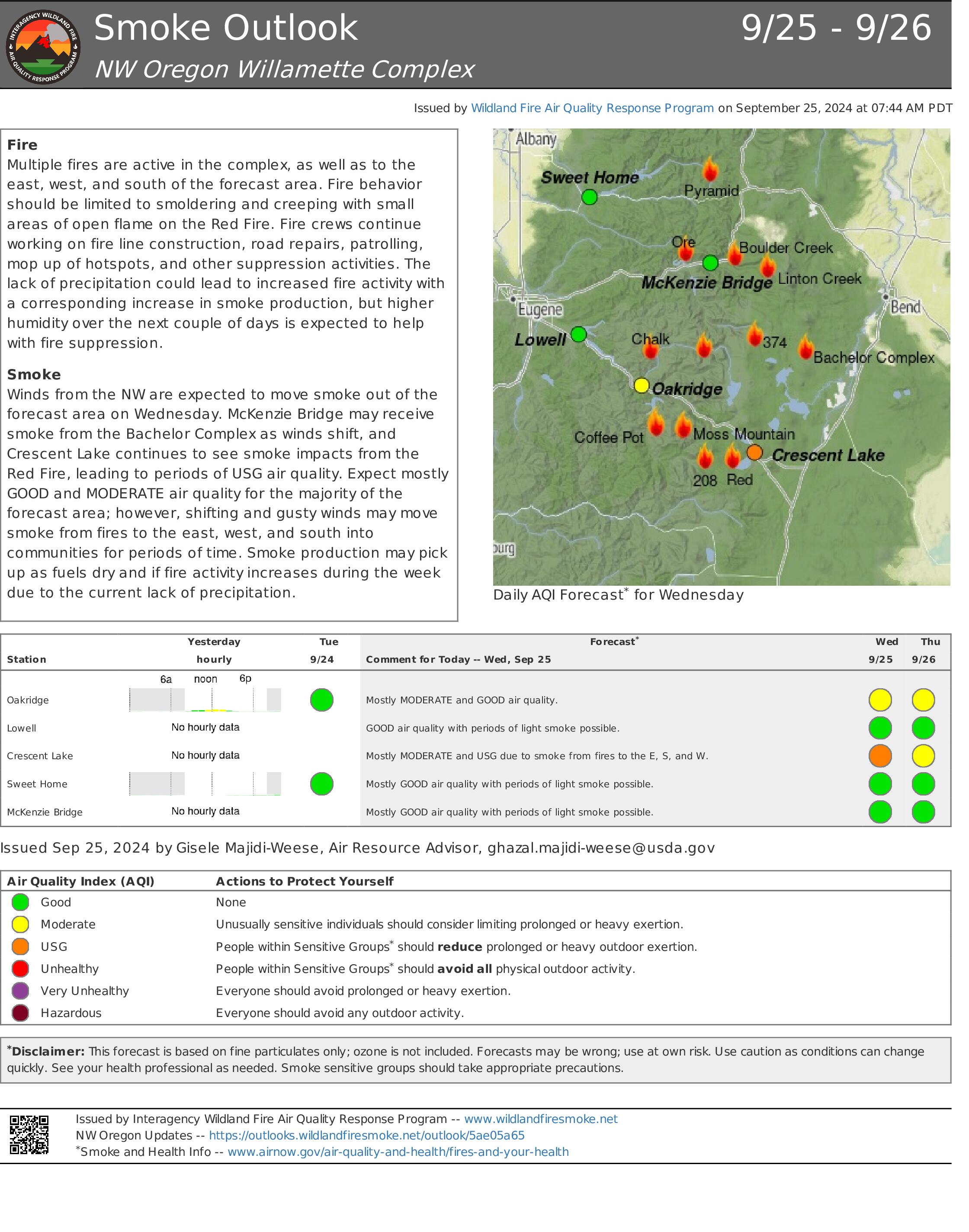
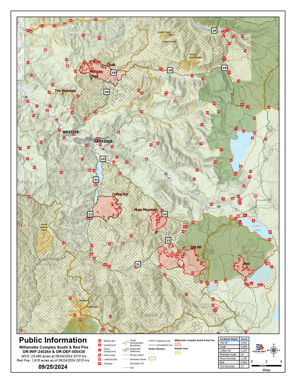
Red Fire Daily Update for Wednesday 09 25 2024
Related Incident: Red Fire
Publication Type: News
Willamette Complex South & Red Fire Update
Red, 208, Moss Mountain, Coffee Pot, Tire Mountain, McKinley Creek and Chalk Fires
Date: Wednesday, September 25, 2024
Fire Causes: Lightning
Email: 2024.willamettecomplex@firenet.gov
Information Phone Line: 541-208-1742
Willamette Complex South: Total Personnel:495| Total Willamette Complex South Acres: 23,444
InciWeb: https://inciweb.wildfire.gov/incident-information/orwif-willamette-complex-fires-south
Facebook: https://www.facebook.com/WillametteComplexFires/
Red Fire: Total Personnel: 50 | Total Red Fire Acres: 1,831
InciWeb: https://inciweb.wildfire.gov/incident-information/ordef-red-fire
Facebook: https://www.facebook.com/2024RedFireOR/
Summary
Monday’s overnight winds of 10 mph created warmer, dryer conditions which reduced fuel moistures within the perimeters of the fires. Tuesday, firefighters prepared to suppress fire activity due to unseasonably high temperatures. Fortunately, there was minimal increase in fire intensity. Low to moderate fire behavior is predicted for today. Smoldering, creeping and small flareups are expected. Crews continue working to firm up indirect control lines and repair resources in places impacted by suppression operations. The Chalk, Coffee Pot, McKinley Creek, and Tire Mountain fires retain their status as 100% contained and are in monitor-and-patrol phase. Crews still work the Coffee Pot, 208 and Red fires to clean ditches, repair roads and tighten up control lines. Members of the public are asked to continue respecting area closures and restrictions.
Red Fire (1,831 acres, 11% containment)
Air support in the form of two “Fire Boss” scoopers dumped 80,000 gallons of water to cool down hot spots yesterday. Currently, the fire is slowly creeping down the slope.
208 Fire (9,013acres, 4% containment)
The 208 Fire continues to move towards the 23 Road on the NW and the 21/2154 roads on the South. Crews are continuing to strengthen those lines along the 23 road to the 423 road and eventually tie in with the existing lines for the Moss Mountain Fire. Crews observed spotty smoke near the northwest corner and will continue to monitor and control the fire. Expect heavy equipment traffic in the area.
Moss Mountain Fire (2,182 acres, 10% containment)
The fire is being kept north of private timber lands by improving and holding forest system road features. Indirect primary lines are implemented to protect values at risk, limit northward spread, and to protect Highway 58, Union Pacific Railroad corridors, the Wolf Mountain Communications site to the north, and infrastructure and cultural sites throughout the fire area. Fire line repair and chipping operations continue. The fire is being kept north of private timber lands by improving and holding forest system road features.
Weather and Fire Behavior
Today will be the polar opposite of Tuesday as a cold front moves through this afternoon. There’s not much moisture left in the cold front, but there is chance of scattered showers. We will experience cool, westerly onshore winds of 5 to 8 mph and temperatures down to around 75 degrees in the lower valley. Afternoon humidity will also be double what it was yesterday. This cold front is followed by potential for general warming and drying for the remainder of the week.
Closures, Fire Restrictions, and Evacuation
- For closure information, visit: https://tinyurl.com/RedFireClosures2024 & https://tinyurl.com/WillFireClosures2024.
- For fire restrictions, visit: https://tinyurl.com/DesFireRestrictions2024 & https://tinyurl.com/WillFireRestrictions2024.
- The Level 1 – BE READY to Evacuate notice remains in effect for the Red Fire. For more information or to sign up for alerts, visit: www.klamathcounty.org/300/emergency-management.
Willamette Complex South Daily Update for Wednesday 09 25 2024
Related Incident: Willamette Complex Fires - South
Publication Type: News
Willamette Complex South & Red Fire Update
Red, 208, Moss Mountain, Coffee Pot, Tire Mountain, McKinley Creek and Chalk Fires
Date: Wednesday, September 25, 2024
Fire Causes: Lightning
Email: 2024.willamettecomplex@firenet.gov
Information Phone Line: 541-208-1742
Willamette Complex South: Total Personnel:495| Total Willamette Complex South Acres: 23,444
InciWeb: https://inciweb.wildfire.gov/incident-information/orwif-willamette-complex-fires-south
Facebook: https://www.facebook.com/WillametteComplexFires/
Red Fire: Total Personnel: 50 | Total Red Fire Acres: 1,831
InciWeb: https://inciweb.wildfire.gov/incident-information/ordef-red-fire
Facebook: https://www.facebook.com/2024RedFireOR/
Summary
Monday’s overnight winds of 10 mph created warmer, dryer conditions which reduced fuel moistures within the perimeters of the fires. Tuesday, firefighters prepared to suppress fire activity due to unseasonably high temperatures. Fortunately, there was minimal increase in fire intensity. Low to moderate fire behavior is predicted for today. Smoldering, creeping and small flareups are expected. Crews continue working to firm up indirect control lines and repair resources in places impacted by suppression operations. The Chalk, Coffee Pot, McKinley Creek, and Tire Mountain fires retain their status as 100% contained and are in monitor-and-patrol phase. Crews still work the Coffee Pot, 208 and Red fires to clean ditches, repair roads and tighten up control lines. Members of the public are asked to continue respecting area closures and restrictions.
Red Fire (1,831 acres, 11% containment)
Air support in the form of two “Fire Boss” scoopers dumped 80,000 gallons of water to cool down hot spots yesterday. Currently, the fire is slowly creeping down the slope.
208 Fire (9,013acres, 4% containment)
The 208 Fire continues to move towards the 23 Road on the NW and the 21/2154 roads on the South. Crews are continuing to strengthen those lines along the 23 road to the 423 road and eventually tie in with the existing lines for the Moss Mountain Fire. Crews observed spotty smoke near the northwest corner and will continue to monitor and control the fire. Expect heavy equipment traffic in the area.
Moss Mountain Fire (2,182 acres, 10% containment)
The fire is being kept north of private timber lands by improving and holding forest system road features. Indirect primary lines are implemented to protect values at risk, limit northward spread, and to protect Highway 58, Union Pacific Railroad corridors, the Wolf Mountain Communications site to the north, and infrastructure and cultural sites throughout the fire area. Fire line repair and chipping operations continue. The fire is being kept north of private timber lands by improving and holding forest system road features.
Weather and Fire Behavior
Today will be the polar opposite of Tuesday as a cold front moves through this afternoon. There’s not much moisture left in the cold front, but there is chance of scattered showers. We will experience cool, westerly onshore winds of 5 to 8 mph and temperatures down to around 75 degrees in the lower valley. Afternoon humidity will also be double what it was yesterday. This cold front is followed by potential for general warming and drying for the remainder of the week.
Closures, Fire Restrictions, and Evacuation
- For closure information, visit: https://tinyurl.com/RedFireClosures2024 & https://tinyurl.com/WillFireClosures2024.
- For fire restrictions, visit: https://tinyurl.com/DesFireRestrictions2024 & https://tinyurl.com/WillFireRestrictions2024.
- The Level 1 – BE READY to Evacuate notice remains in effect for the Red Fire. For more information or to sign up for alerts, visit: www.klamathcounty.org/300/emergency-management.