
Incident Publication
BAER INFORMATION BRIEF Key Elements of a BAER Assessment 09 26 2024
Related Incident: Southern California Post-Fire BAER 2024
Publication Type: News
BAER INFORMATION BRIEF: Key Elements of a BAER Assessment
Forest Service BAER assessment teams are established by Forest Supervisors before wildfires are fully contained. The teams coordinate and work with the USDA Natural Resources Conservation Service (NRCS), Bureau of Land Management (BLM), Fish & Wildlife Service (FWS), National Weather Service (NWS), local counties, State Department of Transportation, and other federal, state, and local agencies to strategically assess potential post-fire impacts to the watersheds burned from wildland fires.
The BAER assessment teams are evaluating watershed conditions to determine the level of potential risks to human life, safety, property, critical natural and cultural-heritage resources, and determine if there are appropriate and effective emergency stabilization measures that can be implemented on federal lands in a timely manner to reduce unacceptable risks from potential flooding and debris flow threats.
The BAER assessment team conducts field surveys and uses science-based models to rapidly evaluate and assess the burned area.
BAER assessment teams are staffed by specially trained professionals that may include: hydrologists, soil scientists, engineers, geologists, biologists, botanists, archeologists, geographic information system mapping specialists, recreation and trails specialists, and others who evaluate the burned area and prescribe emergency response actions to protect the land quickly and effectively.
BAER assessments usually begin before a wildfire has been fully contained.
The BAER assessment team generates a “Soil Burn Severity” map by using satellite imagery which is then validated and adjusted by BAER team field surveys to assess watershed conditions and watershed response to the wildfire. The map identifies areas of soil burn severity by categories of low/unburned, moderate, and high which corresponds to a projected increase in watershed response.
The BAER team presents these findings and treatment recommendations to the Forest Supervisor in an assessment report that identifies immediate and emergency stabilization actions needed to address potential post-fire risks to human life and safety, property, cultural-heritage and critical natural resources on National Forest System lands.
The BAER report describes watershed pre- and post-fire response information, areas of concern for human life, safety and property, and recommended short-term emergency stabilization actions for federal lands that burned.
In most cases, only a portion of the burned area is actually treated.
If the BAER assessment team determines there may be potential emergency situations, the short-term goal is to have flood and erosion control protection measures completed before the first large, damaging rain events occur.
Timely implementation is critical if BAER emergency response actions are to be effective.
The BAER assessment team coordinates with other federal and local agencies, and counties that assist private landowners in preparing for increased run-off and potential flooding.
Federal assistance to private landowners regarding post-fire potential impacts is the primary responsibility of the NRCS through the Emergency Watershed Protection (EWP) program (www.nrcs.usda.gov/wps/portal/nrcs/main/national/programs/landscape/ewpp/)
NRCS in coordination with additional state, local and federal agencies conduct damage survey reports for the private land adjacent to and downstream from the burned areas. NRCS uses these reports, along with the BAER team’s assessment report, to develop recommended emergency measures for businesses and private home and landowners to reduce the impacts to their property from potential increased water and debris flows.
BAER SAFETY MESSAGE: Everyone near and downstream from the burned areas should remain alert and stay updated on weather conditions that may result in heavy rains and increased water runoff. Flash flooding may occur quickly during heavy rain events--be prepared to act. Current weather and emergency notifications can be found at the National Weather Service website: www.weather.gov/lox/.
BAER INFORMATION BRIEF Forest Service BAER Program Overview 09 26 2024
Related Incident: Southern California Post-Fire BAER 2024
Publication Type: News
BAER INFORMATION BRIEF: Forest Service BAER Program Overview
The Burned Area Emergency Response (BAER) program is designed to identify and manage potential risks to resources on National Forest System lands and reduce these threats through appropriate emergency measures to protect human life and safety, property, and critical natural or cultural resources. BAER is an emergency program for stabilization work that involves time-critical activities to be completed before the first damaging event to meet program objectives:
BAER Objectives:
- Determine whether imminent post-wildfire threats to human life and safety, property, and critical natural or cultural resources on National Forest System lands exist and take immediate actions, as appropriate, to manage the unacceptable risks.
- If emergency conditions are identified, mitigate significant threats to health, safety, human life, property, and critical cultural and natural resources.
- Prescribe emergency response actions to stabilize and prevent unacceptable degradation to natural and cultural resources, to minimize threats to critical values resulting from the effects of a fire, or to repair/replace/construct physical improvements necessary to prevent degradation of land or resources.
- Implement emergency response actions to help stabilize soil; control water, sediment and debris movement and potentially reduce threats to the BAER critical values identified above when an analysis shows that planned actions are likely to reduce risks substantially within the first year following containment of the fire.
- Monitor the implementation and effectiveness of emergency treatments that were applied on National Forest System lands.
While many wildfires cause minimal damage to the land and pose few threats to the land or people downstream, some fires result in damage that requires special efforts to reduce impacts afterwards. Loss of vegetation exposes soil to erosion; water run-off may increase, and cause flooding, soil and rock may move downstream and damage property or fill reservoirs putting community water supplies and endangered species at-risk.
The BAER team presents these findings in an assessment report that identifies immediate and emergency actions needed to address post-fire risks to human life and safety, property, cultural and critical natural resources. This includes early detection and rapid response (EDRR) treatments to prevent the spread of noxious weeds into native plant communities. The BAER report describes watershed pre- and post-fire watershed response information, areas of concern for life and property, and recommended short-term emergency stabilization measures for Forest Service lands that burned.
In most cases, only a portion of the burned area is actually treated. Severely burned areas steep slopes, and places where water run-off will be excessive and may impact important resources, are focus areas and described in the BAER assessment report if they affect critical values. Time is critical if the emergency stabilization measures are to be effective.
A BAER assessment team conducts field surveys and uses science-based models to rapidly evaluate and assess the burned area and prescribe emergency stabilization measures. The team generates a “Soil Burn Severity” map by using satellite imagery which is then validated and adjusted by BAER team field surveys to assess watershed conditions and model potential watershed response from the wildfire. The map identifies areas of soil burn severity by categories of very low/unburned, low, moderate, and high which may correspond to a projected increase in watershed response. The higher the burn severity, the less the soil will be able to absorb water when it rains. Without absorption, there will be increased run-off with the potential of flooding.
BAER Funding:
Special Emergency Wildfire Suppression funds are authorized for BAER activities and the amount of these expenses varies with the severity of the fire season. Some years see little BAER activity while other years are extremely busy.
Because of the emergency nature of BAER, initial requests for funding of proposed BAER treatments are supposed to be submitted by the Forest Supervisor to the Regional Office within 7 days of total containment of the fire. The Regional Forester’s approval authority for individual BAER projects is limited. Approval for BAER projects exceeding this limit is to the Washington Office.
BAER SAFETY MESSAGE: Everyone near and downstream from the burned areas should remain alert and stay updated on weather conditions that may result in heavy rains and increased water runoff. Flash flooding may occur quickly during heavy rain events--be prepared to act. Current weather and emergency notifications can be found at the National Weather Service website: www.weather.gov/lox/.
Forest Service BAER Soil Scientist Explains How Wildfire Affects Burned Watersheds 10 03 2024
Related Incident: Southern California Post-Fire BAER 2024
Publication Type: News
Forest Service BAER Soil Scientist Explains How Wildfire Affects Burned Watersheds
After the fire is contained, the emergency continues. While a forest fire can have a huge impact on trees and shrubs, the fire also affects the soil.
To understand how the Airport Fire influenced soils and how these effects contribute to post-fire watershed response and watershed health over time, BAER team soil scientist Eric Nicita from the Eldorado National Forest collects soil burn severity data across the burned area within the fire perimeter. This data will later be used in erosion, stream flow, and debris flow models that help managers make forest-wide predictions and determine if treatments are necessary and feasible.
Soil burn severity (SBS) is categorized from unburned through low, moderate, and high severity. Unburned soils are areas that were not touched by the fire, and high severity soils sustained more intense effects. The main indicators that soil scientists use to determine SBS impacts to soil structure and soil cover.
Unburned soil sticks together in clumps due to the roots, and mycelium, the fine, root-like fungi that hold the soil together. After a fire, the structure changes. The more soil structure is altered, the more prone the soil is to erosion and depending on the severity of the burn, the roots could be entirely burned slowing recovery.
A fire also alters soil cover. The duff layer, which is composed of organic material like twigs, leaves and decomposing material, burns and becomes ash. Ash is a fine layer that sits on the top of the soil. Because ash is so light, it is easily blown around or moved by water. During a flooding event, the ash then becomes an input to the watershed. Soil cover also protects soil from erosion. The less soil cover, the more erosion and runoff the burned hillslopes experience.
One technique that Nicita uses in the field is a water repellency test to examine potential runoff across the burn zone. Soils are naturally waxy due to the presence of mycelium, meaning water will pool on top before seeping into the soil. A fire exacerbates that characteristic, and moderate to high severity burned soils have increased post-fire water repellency. Explains Nicita, because burned soils have a looser structure, they are likely to erode faster during a flooding event, adding debris and mud to the watershed. This impacts water flow and quality and can cause downstream effects such as impacts to human infrastructure and aquatic organism health.
The data that Nicita collects is used to develop the Soil Burn Severity (SBS) map for the Airport Fire on the Cleveland National Forest. This map is used by other scientists, like geologists and hydrologists, during BAER work. After the fire, this map will continue to be used by scientists, particularly hydrologists, to monitor post-fire impacts to watersheds and determine if treatments are needed.
It is important for the Forest to have these maps and data to best prepare for the future – knowing this enables them to ensure they can prepare for flooding events and help protect critical forest values, like watershed health and human safety.
NOTE: See related photos to this article under the “Photos” Tab on this Southern CA Post-Fire BAER InciWeb page: Cabdf Southern California Postfire Baer 2024 Incident Photographs | InciWeb (wildfire.gov). Also see “Related Information” PDF article document containing related article photos below.
BAER SAFETY MESSAGE: Everyone near and downstream from the burned areas should remain alert and stay updated on weather conditions that may result in heavy rains and increased water runoff. Flash flooding may occur quickly during heavy rain events--be prepared to act. Current weather and emergency notifications can be found at the National Weather Service website: www.weather.gov/lox/.
###
Morning Update Wapiti Fire Thursday 09 26 2024
Related Incident:
Publication Type: News
Wapiti Fire Statistics
- Size: 125,508 acres
- Completion: 72%
- Total Personnel: 302
- Location: near Grandjean, ID
- Reported: July 24, 2024
- Cause: Lightning
For More Information
- InciWeb: https://inciweb.wildfire.gov/incident-information/idbof-wapiti-fire
- Facebook: https://www.facebook.com/wapitifireinfo2024
- Linktree: https://linktr.ee/WapitiFireInfo2024
- Interactive Map: https://tinyurl.com/WapitiFireInfoMap
Special Updates: As the weekend approaches, please verify your recreation and hunting plans against the existing closures throughout the area. Both the Wapiti and Frog Fires have area closures in place, affecting roads, trails, and campgrounds. Check the links throughout the update to find the information most applicable to your travel plans. And please remember to travel slowly and cautiously through any ongoing fire area.
Weather: Yesterday’s winds were higher than forecast, with gusts between 40 and 50 mph recorded at the highest elevations. Today will be breezy again but gusts should only reach into the 20 to 25 mph speed. Temperatures will cool today before beginning to rise again by the weekend. The outlook is showing no signs of precipitation soon, meaning September will close with warm and dry conditions that could lead to continued moderate fire behavior on both Wapiti and Frog Fires.
Current Situation: Despite yesterday’s strong winds, the Wapiti Fire showed just 29 acres of growth. The fire was most active near Copper Mountain. Helicopters dropped buckets of water on the flames until all aviation resources were forced to land because of gusts reaching over 40 mph. Fire engines and personnel did continue to work on the fire and were able to limit the fire’s spread. Resources remain spread out around the fire to quickly respond to any increase in fire behavior.
While several other areas did pick up in activity, they were all interior to the existing fire perimeter and not near existing containment lines. Increased smoke from similar hot areas is expected to continue until significant moisture – rain or snow – covers the fire area. The fire has burned in a mosaic pattern over the landscape, meaning there are places where the fire burned very intensely and consumed nearly all vegetation while other areas saw less intense fire activity that burned through brush and small trees but left mature trees standing.
Suppression repair work also continues in several locations. Equipment and personnel are making great progress towards opening the Grandjean Road. Once they can safely access Grandjean, additional evaluation of fire damage and suppression repair needs will commence. At that time, a timeline for safe access by homeowners will be evaluated as well. Near Stanley Lake, fire crews are cutting down trees that could pose a hazard to roadways, trails, and infrastructure. (See the Wapiti Fire InciWeb and Facebook page for images of the Stanley Lake area and campground.)
Evacuations: Evacuation status for Stanley Zone 1 is currently at READY. Stanley Zones 2 – 5 and Kasino are no longer in an evacuation status. Sign up for Custer County CodeRED emergency notifications: text CUSTER to 99411 or enroll at https://public.coderedweb.com/CNE/BF28E45537FF.
All Boise County evacuation levels have been lifted; residents should remain alert for any change in conditions which could reinitiate an evacuation status. Sign up for Boise County Alert Sense emergency notifications at https://public.alertsense.com/SignUp/publicUser.aspx?regionid=1163.
For evacuation information on the Wapiti Fire, please see the Custer County Sheriff’s Facebook page, https://www.facebook.com/p/Custer-County-Sheriff-Idaho-61558947312289/, and the Boise County Sheriff’s Facebook page, https://www.facebook.com/boisecountysheriff/.
Closures: The Wapiti Fire area closure covers portions of the Sawtooth, Boise, and Salmon National Forests. Please reference the map and description at https://inciweb.wildfire.gov/incident-closures/idbof-wapiti-fire. Recreationalists and hunters should reference this map and obey all posted signage regarding the closure area and any related road, trail, and campground closures.
An interactive map for all closures on the Boise National Forest is found at https://experience.arcgis.com/experience/642380b0eb124c8cab6bd9ad3d7146ad/page/Overview/#data_s=id%3AdataSource_5-1888bd00a2c-layer-13-1888bd00b53-layer-16%3A82.
Morning Update Frog Fire Thursday 09 26 2024
Related Incident: Frog
Publication Type: News
Frog Fire Statistics
- Size: 3,112 acres
- Containment: 42%
- Total Personnel: 141
- Location: east of Clayton, ID
- Reported: September 7, 2024
- Cause: Lightning
For More Information
InciWeb: https://inciweb.wildfire.gov/incident-information/idstf-frog
Facebook: https://www.facebook.com/sawtoothnationalforest
Current Situation: The high elevation ridges west of the Frog Fire sheltered it from the strongest of yesterday’s winds. Gusts up to 15 were reported immediately on the fire; however, gusts at the ridges above the fire were well above 40 mph. Although there was an increase in fire activity, it was not as much as fire managers had anticipated and no measurable growth was recorded on the fire.
Firefighters were able to continue working directly along the fire’s active edge and make progress towards additional containment. Helicopters supported the ground crews by dropping buckets of water on the flames until peak wind gusts forced them to land. Crews are staying overnight in the fire area to enable them to start work early in the morning which aids suppression efforts by maximizing work time, without the added time hiking in and out or being flown via helicopter. A remote fire camp is still located in the Yankee Fork to support those crews and the other resources working in lower areas of the Frog Fire, including throughout Big Boulder Creek.
Evacuations: There are currently no evacuations related to the Frog Fire.
Closures: The area closure in place around the Frog Fire includes FS 667 (Big Boulder Creek Road) and Trail 047 where adjacent to the closure boundary. The closure excludes FS Roads 669 and 670 and Trail 682. Hunters and recreationalists should familiarize themselves with this closure information prior to entering the vicinity. Please reference the map and read the full closure description at https://inciweb.wildfire.gov/incident-closures/idstf-frog.
Firefighters successfully completed 192 acres of prescribed burning on Carpenter Ridge 09 26 2024
Related Incident:
Publication Type: Announcement
On Wednesday, Sept. 25, BLM Southwest District Fire successfully treated about 192 acres on Carpenter Ridge in the Uncompahgre Field Office, CO.
For more information on prescribed fire treatments in the Southwest District, visit the Southwest District BLM Prescribed Fire Information InciWeb page: https://inciweb.wildfire.gov/incident-information/cosjd-southwest-district-blm-prescribed-fire. Follow us on Facebook https://www.facebook.com/BLMMontroseFireUnit and Twitter https://twitter.com/SWD_Fire.
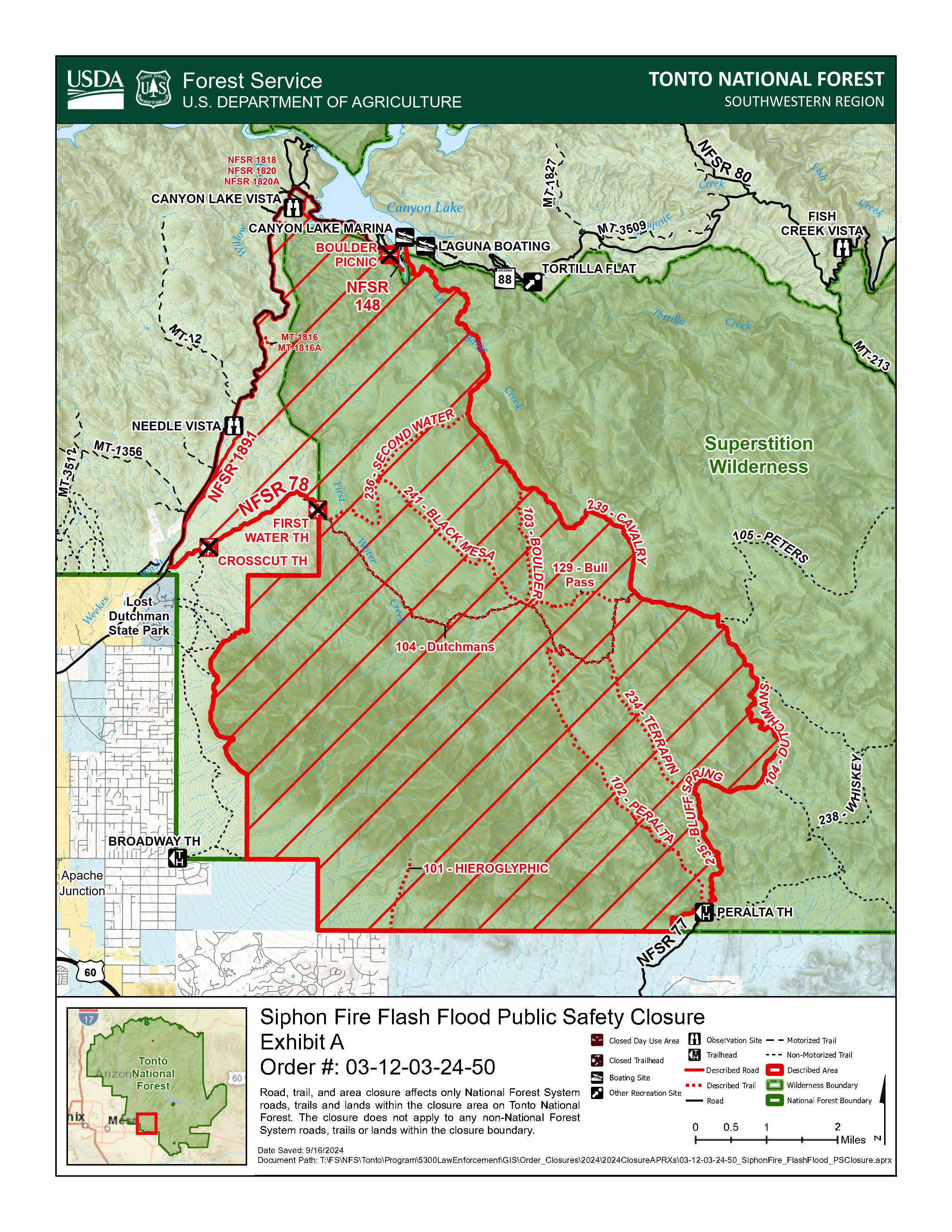
Siphon Fire Trails Closure Order 09 25 2024
Related Incident: Siphon Fire
Publication Type: Closures
Please be advised that Mesa Ranger District has issued a revised Siphon Fire Post Fire Recovery and Flash Flood Public Safety Closure to provide for public health and safety due to increased flash flood potential, and to allow for natural resource protection and burn area recovery within the Siphon Fire area on #TontoNF.
This order shall be in effect from Sept. 19, 2024, at 6 a.m. through Oct. 20, 2024, at 6 p.m., unless rescinded. For a copy of this order, visit: https://www.fs.usda.gov/alerts/tonto/alerts-notices.
Lane County Sheriffs Office cancels remaining evacuation areas near Boulder Creek Fire 09 25 2024
Related Incident: North Willamette Complex
Publication Type: Announcement
Cooler, wetter weather and hard work by fire personnel are allowing Lane County Sheriff’s Office to cancel the remaining evacuation levels near the Boulder Creek Fire, including Scott Creek Road and the North Belknap Springs Road areas.
Forest closures remain in effect in several areas across eastern Lane County and people should continue to respect those closures. Updated forest closure information can be found on the Willamette National Forest website: https://www.fs.usda.gov/detail/willamette/fire/?cid=fseprd552029
Residents are still encouraged to sign up for emergency alerts at www.LaneAlerts.org.
Airport Fire Incident Update 09 25 2024
Related Incident:
Publication Type: News
Location: Trabuco Canyon, CA
Personnel: 461
Start date: 09/09/24 1:00 p.m.
Cause: Human
Size: 23,519
Percent contained: 95%
For a printable version of today's complete update for the Airport Fire, please see the related link below.
A Type 3 Incident Management Team is now in command of the Airport fire, and will begin its first full day of operations after shadowing the outgoing team yesterday. The incident command post will be located in Lake Elsinore, beginning Wednesday.
The fire has remained within current containment lines. Some fireline work remains in order to achieve the 100% containment goal and it is progressing. Most of this fireline work is being focused in the North side of the fire. However, resources are patroling all sections constantly, watching for any unusual activity. Simutleneously, other resources are coordinating with Burn Area Emergency Response (BAER) teams and with suppression repair groups in preparation for future rain events.
Air attack and drones with infrared technology, to detect hot spots, will remain with the Type 3 team. Vegetation is very dry right now with a high potential for ignition. Smoke may be observed, and unburned fuels within the fire perimeter continue to burn. Shifting winds in late afternoon may be produced by the Lake Elsinore effect.
Hikers and mountain bikers bikers have been observed on some of the trails within the fire’s footprint. We would like to remind everyone that a closure order is in effect for the Trabuco Ranger District of the Cleveland National Forest. Please do not enter the closure area or recreate on any of the firelines constructed for the incident. https://www.fs.usda.gov/alerts/cleveland/alerts-notices/?aid=90727
Southern California Edison Electric Utility Company continues to replace damaged power poles and lines in the Lake Elsinore area and will be using helicopters to transport and place these poles. Operations will be scheduled during times of minimal highway use. However, all motorists should be aware that traffic delays can occasionally occur for extended periods. Please plan accordingly
Prescribed burn planned on Sept 2628 2024 for the West Dolores Rim Area 09 25 2024
Related Incident:
Publication Type: Announcement
If conditions are favorable, BLM Southwest District Fire plans to conduct prescribed burns on West Dolores Rim in the Tres Rios Field Office to reduce hazardous fuels and improve public land health. The treatments will be implemented as follows:
• Thurs. Sept. 26: Crews will conduct hand and aerial (helicopter) ignitions of about 634 acres of mixed mountain shrub and pinon-juniper in Unit 42A, located approx. 3 miles east of Egnar, CO.
• Fri. Sept. 27 or Sat. Sept. 28: If resources are available, crews will conduct ground ignitions of about 124 acres of ponderosa pine in Unit 20A, located approx. 7.4 miles northeast of Dove Creek, CO.
View the map and full announcement on the BLM website: https://www.blm.gov/.../sept-26-28-blm-conduct-prescribed....
More information on Southwest District prescribed fuel treatments at InciWeb_Southwest District BLM Prescribed Fire and follow our Facebook-BLM Southwest District or Twitter-@SWD_Fire pages.