
Incident Publication
FIRE SUMMARY SEPTEMBER 16 2024 09 16 2024
Related Incident:
Publication Type: News
There have been nine (9) new fires reported on the Salmon-Challis National Forest since the last update on Monday, September 9, 2024. To date, there have been 59 wildfires reported on the Salmon-Challis National Forest. 40 of the fires have been declared out.
Ebenezer (September 15): is approximately 27 miles west of North Fork on the North Fork Ranger District. The fire is approximately 0.10 acres burning in a down log.
Colson (September 14): is approximately 30 miles southwest of North Fork on the North Fork Ranger District. The fire is approximately 0.10 acres burning in a snag.
Napias (September 13): is located approximately 11 miles west of Salmon on the Salmon-Cobalt Ranger District. The fire is approximately 0.25 acres burning in spruce and fir is out.
Nugget (September 13): is located approximately 40 miles west of Salmon on the North Fork Ranger District in the Frank Church River of No Return Wilderness. The 0.10 acre fire is burning in fir.
Coral (September 11): is located approximately 26 miles of Mackay on the Lost River Ranger District. The 0.10 acre fire burning in subalpine fir is 100% contained.
Twin Bridges (September 11): is located approximately 32 miles northwest of Mackay on the Lost River Ranger District in the Jim McClure-Jerry Peak Wilderness. The 0.10 acre fire is burning in grass and shrubs.
Lightning (September 11): is located approximately 13 miles northwest of Sunbeam on the Challis-Yankee Fork Ranger District. The fire is estimated at five (5) acres burning in spruce and fir.
Cougar (September 11): s located approximately three (3) miles south of the Garden Fire on the North Fork Ranger District in the Frank Church River of No Return Wilderness. The fire is estimated at five (5) acres in size burning in grass and brush.
Garden (September 8): is located approximately two (2) miles southwest of the confluence of Panther Creek and the Main Salmon River on the North Fork Ranger District in the Frank Church River of No Return Wilderness. The fire is approximately 230 acres burning in grass, brush, and timber.
Shell (September 3): is located approximately 28 miles northwest of Challis on the Middle Fork Ranger District in the Frank Church River of No Return Wilderness. The fire remains at 0.10 acre and is burning in fir.
Vanity (September 3): is located approximately 42 miles west of Challis on the Middle Fork Ranger District. The approximately 600 acre fire is burning in subalpine fir and is surrounded by the 2012 Halstead Fire. Fire managers are using a point protection strategy (a wildfire response strategy, which protects specific assets or highly valued resources from the wildfire without directly halting the continued spread of the wildfire) to minimize exposure to fire personnel while protecting identified values. Specific values potentially threatened with this fire include Forest Service infrastructure. 23 firefighters are assigned to the fire. The fire can be found on InciWeb at https://inciweb.wildfire.gov/incident-information/idscf-vanity. The Beaver Creek Road #008 is closed for public safety due to the Vanity Fire. The closure can be found at: https://www.fs.usda.gov/Internet/FSE_DOCUMENTS/fseprd1203351.pdf.
Silver (September 2): is located approximately 35 miles southwest of Salmon on the Salmon-Cobalt Ranger District. Two (2) firefighters are on scene working to suppress the 0.25 acre fire which is 100% contained and controlled.
Red Rock (September 2): is located approximately two (2) miles east of Yellowjacket Guard Station on the Salmon-Cobalt Ranger District. A Complex Incident Management Team is managing the fire and information is being reported separately. The fire can be found on InciWeb at https://inciweb.wildfire.gov/incident-information/idscf-red-rock-fire.
Reynolds (August 22): is located approximately 21 miles northwest of Indianola, approximately 5.5 miles northwest of Horse Creek Hot Springs Campground on the Idaho/Montana border. Fire is estimated to be approximately 2,671 acres burning in spruce and fir. The Bitterroot National Forest is lead on this fire.
Birch (August 17): is located on the west side of the Middle Fork of the Salmon River on Norton Ridge on the Middle Fork Ranger District in the Frank Church River of No Return Wilderness. The 1,049 acre fire is burning in subalpine fir. The fire is surrounded by the 2022 Norton Fire and fire scars from the fires of 2000.
Greyhound (August 11): is located approximately 46 miles northwest of Challis on the Middle Fork Ranger District. The 97 acre fire is burning in subalpine fir and lodgepole pine on the edge of the 2021 Boundary Creek Fire. Firefighter and public safety is the number one priority for the Greyhound Fire. During initial size up for the fire, several safety concerns were identified including: the remote location of the fire, steep and inaccessible terrain, heavy dead and down fuels with a substantial snag component, private property and associated mining infrastructure, and lack of safe ingress and egress for firefighters. Fire managers will be monitoring the fire with reconnaissance flights and lookouts. NFS Road #011 is a one way in, one way out roadway and is closed for public safety, closure can be found at https://www.fs.usda.gov/Internet/FSE_DOCUMENTS/fseprd1201939.pdf.
Black Eagle (August 5): is located approximately 12 miles west of Forney on the North Fork Ranger District in the Frank Church River of No Return Wilderness. The fire is burning in lodgepole and subalpine fir. A Complex Incident Management Team is managing the fire and information is being reported separately. The fire can be found on InciWeb at https://inciweb.wildfire.gov/incident-information/idscf-black-eagle-fire.
Wapiti (July 24): started on the Boise National Forest, burned onto the Sawtooth National, and around August 24th burned onto the Salmon-Challis National Forest. A Complex Incident Management Team is managing the fire. Information can be found on InciWeb at https://inciweb.wildfire.gov/incident-information/idbof-wapiti-fire.
Deer (July 25): The lightning fire is located approximately 33 miles northwest of Challis, southeast of Pinyon Peak on the Middle Fork Ranger District in the Frank Church River of No Return Wilderness. Loon Creek Guard Station is east of the fire. The fire, burning in grass and conifers is estimated at approximately 54 acres. The fire is burning on both side of Rabbit Creek, in the 2006 Trail Creek Fire. Fire managers are using a point protection strategy (a wildfire response strategy, which protects specific assets or highly valued resources from the wildfire without directly halting the continued spread of the wildfire) to minimize exposure to fire personnel while protecting identified values. The strategy takes into account exposure to firefighters, values at risk, and wilderness values. Specific values potentially threatened with this fire include private land and Forest Service infrastructure.
Thunder (July 24): The lightning fire is located approximately two (2) miles northwest of Williams Lake and approximately 12 miles southwest of Salmon. The fire is 100% contained and controlled, fire size is estimated to be 2,474 acres and is burning in timber, sagebrush, and grass.
Weather: Thunderstorms return to the region this afternoon, with gust potential over 50 mph and threat for locally heavy rainfall. Rain becomes more widespread and heavier through the night and then continues into Tuesday. Another system arrives Wednesday with additional rainfall forecast. Temperatures are expected to remain cool through the week.
The forest is asking visitors to be aware of the fire danger for the Salmon-Challis National Forest. Ensure your campfire is dead out. If it is too hot to touch, it is too hot to leave! One Less Spark Means One Less Wildfire. Since June 1, Forest employees have found and extinguished at least 13 abandoned campfires.
Nationally, there are 55 uncontained large fires being managed under a full suppression strategy and 39 large fires managed under a strategy other than full suppression.
Visit our website at: www.fs.usda.gov/scnf/, ‘Like Us’ on Facebook @salmonchallisnf, and ‘Follow Us’ on X @salmonchallisnf.
####
FIRE SUMMARY SEPTEMBER 23 2024 09 23 2024
Related Incident:
Publication Type: News
There have been three (3) new fires reported on the Salmon-Challis National Forest since the last update on Monday, September 16, 2024. To date, there have been 62 wildfires reported on the Salmon-Challis National Forest. 48 of the fires have been declared out.
Endoah (September 19): is approximately 40 miles northwest of Stanley on the Middle Fork Ranger District in the Frank Church River of No Return Wilderness. The 0.10 acre fire burning in brush, spruce, and fir is 100% contained and controlled.
Diamond (September 19): is approximately 12 miles northwest of Salmon on the Salmon-Cobalt Ranger District. The 0.10 acre fire burning in spruce and fir is out.
Colson 2 (September 16): is approximately 30 miles southwest of North Fork on the North Fork Ranger District. The 11 acre fire burning in grass and brush is out.
Ebenezer (September 15): is approximately 27 miles west of North Fork on the North Fork Ranger District. The fire is approximately 0.10 acres burning in a down log.
Colson (September 14): is approximately 30 miles southwest of North Fork on the North Fork Ranger District. The fire is approximately 0.10 acres burning in a snag is out.
Nugget (September 13): is located approximately 40 miles west of Salmon on the North Fork Ranger District in the Frank Church River of No Return Wilderness. The 15 acre fire is burning in fir.
Coral (September 11): is located approximately 26 miles of Mackay on the Lost River Ranger District. The 0.10 acre fire burning in subalpine fir is out.
Twin Bridges (September 11): is located approximately 32 miles northwest of Mackay on the Lost River Ranger District in the Jim McClure-Jerry Peak Wilderness. The 0.10 acre fire is burning in grass and shrubs is out.
Lightning (September 11): is located approximately 13 miles northwest of Sunbeam on the Challis-Yankee Fork Ranger District. The fire estimated at five (5) acres burning in spruce and fir is out.
Cougar (September 11): s located approximately three (3) miles south of the Garden Fire on the North Fork Ranger District in the Frank Church River of No Return Wilderness. The fire is estimated at 12 acres in size burning in grass and brush.
Garden (September 8): is located approximately two (2) miles southwest of the confluence of Panther Creek and the Main Salmon River on the North Fork Ranger District in the Frank Church River of No Return Wilderness. The fire is approximately 250 acres burning in grass, brush, and timber.
Shell (September 3): is located approximately 28 miles northwest of Challis on the Middle Fork Ranger District in the Frank Church River of No Return Wilderness. The 0.10 acre fire burning in fir is out.
Vanity (September 3): is located approximately 42 miles west of Challis on the Middle Fork Ranger District. The approximately 600 acre fire is burning in subalpine fir and is surrounded by the 2012 Halstead Fire. Fire managers are using a point protection strategy (a wildfire response strategy, which protects specific assets or highly valued resources from the wildfire without directly halting the continued spread of the wildfire) to minimize exposure to fire personnel while protecting identified values. Specific values potentially threatened with this fire include Forest Service infrastructure. The fire can be found on InciWeb at https://inciweb.wildfire.gov/incident-information/idscf-vanity.
Silver (September 2): is located approximately 35 miles southwest of Salmon on the Salmon-Cobalt Ranger District. Two (2) firefighters are on scene working to suppress the 0.25 acre fire is out.
Red Rock (September 2): is located approximately two (2) miles east of Yellowjacket Guard Station on the Salmon-Cobalt Ranger District. A Complex Incident Management Team is managing the fire and information is being reported separately. The fire can be found on InciWeb at https://inciweb.wildfire.gov/incident-information/idscf-red-rock-fire.
Reynolds (August 22): is located approximately 21 miles northwest of Indianola, approximately 5.5 miles northwest of Horse Creek Hot Springs Campground on the Idaho/Montana border. Fire is estimated to be approximately 2,671 acres burning in spruce and fir. The Bitterroot National Forest is lead on this fire.
Birch (August 17): is located on the west side of the Middle Fork of the Salmon River on Norton Ridge on the Middle Fork Ranger District in the Frank Church River of No Return Wilderness. The 1,049 acre fire is burning in subalpine fir. The fire is surrounded by the 2022 Norton Fire and fire scars from the fires of 2000.
Greyhound (August 11): is located approximately 46 miles northwest of Challis on the Middle Fork Ranger District. The 97 acre fire is burning in subalpine fir and lodgepole pine on the edge of the 2021 Boundary Creek Fire. Firefighter and public safety is the number one priority for the Greyhound Fire. During initial size up for the fire, several safety concerns were identified including: the remote location of the fire, steep and inaccessible terrain, heavy dead and down fuels with a substantial snag component, private property and associated mining infrastructure, and lack of safe ingress and egress for firefighters. Fire managers will be monitoring the fire with reconnaissance flights and lookouts.
Black Eagle (August 5): is located approximately 12 miles west of Forney on the North Fork Ranger District in the Frank Church River of No Return Wilderness. The fire is burning in lodgepole and subalpine fir. A Complex Incident Management Team is managing the fire and information is being reported separately. The fire can be found on InciWeb at https://inciweb.wildfire.gov/incident-information/idscf-black-eagle-fire.
Wapiti (July 24): started on the Boise National Forest, burned onto the Sawtooth National, and around August 24th burned onto the Salmon-Challis National Forest. A Complex Incident Management Team is managing the fire. Information can be found on InciWeb at https://inciweb.wildfire.gov/incident-information/idbof-wapiti-fire.
Deer (July 25): The lightning fire is located approximately 33 miles northwest of Challis, southeast of Pinyon Peak on the Middle Fork Ranger District in the Frank Church River of No Return Wilderness. Loon Creek Guard Station is east of the fire. The fire, burning in grass and conifers is estimated at approximately 54 acres. The fire is burning on both side of Rabbit Creek, in the 2006 Trail Creek Fire. Fire managers are using a point protection strategy (a wildfire response strategy, which protects specific assets or highly valued resources from the wildfire without directly halting the continued spread of the wildfire) to minimize exposure to fire personnel while protecting identified values. The strategy takes into account exposure to firefighters, values at risk, and wilderness values. Specific values potentially threatened with this fire include private land and Forest Service infrastructure.
Thunder (July 24): The lightning fire is located approximately two (2) miles northwest of Williams Lake and approximately 12 miles southwest of Salmon. The fire is 100% contained and controlled, fire size is estimated to be 2,474 acres and is burning in timber, sagebrush, and grass.
Weather: Strong high pressure will develop over the northern Great Basin and will start to have an effect tomorrow as temperatures warm and humidity decreases slightly. This will continue until Wednesday afternoon, when a trough moves through southern Canada and Montana. There is a slight chance of showers over the very northern end of the Salmon-Challis National Forest on Wednesday night/Thursday morning. Elsewhere, just expect wind to increase, but humidity is expected to stay high.
The forest is asking visitors to be aware of the HIGH fire danger for the Salmon-Challis National Forest. Ensure your campfire is dead out. If it is too hot to touch, it is too hot to leave! One Less Spark Means One Less Wildfire. Since June 1, Forest employees have found and extinguished at least 13 abandoned campfires.
Nationally, there are 42 uncontained large fires being managed under a full suppression strategy and 17 large fires managed under a strategy other than full suppression.
Visit our website at: www.fs.usda.gov/scnf/, ‘Like Us’ on Facebook @salmonchallisnf, and ‘Follow Us’ on X @salmonchallisnf.
####
KXGV Radio Show Sept 23 2024 09 23 2024
Related Incident:
Publication Type: Announcement
KXGV Radio Host Uncle Doug interviews Resource Advisor Jason Nez from Great Basin Team 2 on the Middle Fork Complex on Sept. 23 2024.
https://youtu.be/4qmjcRPPvBQ?si=Y-whRfcsKrp1JkE0
Red Fire Daily Update for Monday 09 23 2024
Related Incident: Red Fire
Publication Type: News
Willamette Complex South & Red Fire Update
Red, 208, Moss Mountain, Coffee Pot, Tire Mountain, McKinley Creek and Chalk Fires
Date: Monday, September 23 2024
Fire Causes: Lightning
Email: 2024.willamettecomplex@firenet.gov
Information Phone Line: 541-208-1742
Willamette Complex South: Total Personnel:473| Total Willamette Complex South Acres: 23,410
InciWeb: https://inciweb.wildfire.gov/incident-information/orwif-willamette-complex-fires-south
Facebook: https://www.facebook.com/WillametteComplexFires/
Red Fire: Total Personnel: 50 | Total Red Fire Acres: 1,822
InciWeb: https://inciweb.wildfire.gov/incident-information/ordef-red-fire
Facebook: https://www.facebook.com/2024RedFireOR/
Summary
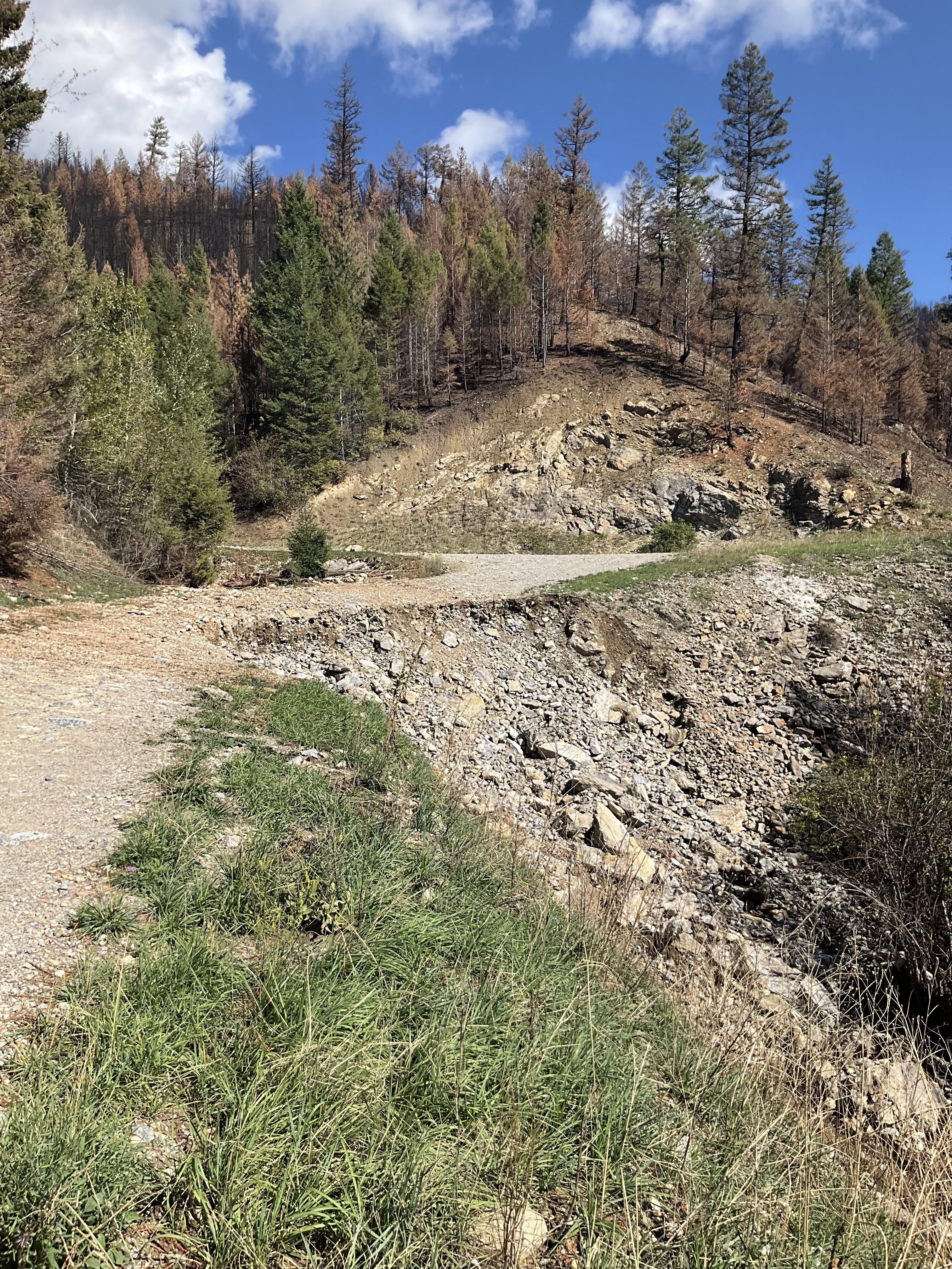
Fire growth continues to be minimal and remains within the established perimeters. Sunday’s warmer and drier air created some light smoke during the morning hours. Creeping and smoldering fire behavior may be witnessed in the fine fuels, grasses and needles present in the fire area. Crews are working to firm up indirect control lines and repair resources in places impacted by suppression operations. The Chalk Fire, Coffee Pot Fire, McKinley Creek Fire, and Tire Mountain Fire retain their status as 100% contained and are in monitor-and-patrol phase. Crews are chipping, clearing brush and woody debris, and repairing roads impacted by fire suppression activities. Tasks are prioritized under the advisement of resource specialists. Scientifically and fiscally responsible forest practices are being utilized to reduce impacts on sensitive terrain and vegetation as much as possible. Members of the public are asked to continue respecting area closures and restrictions.
Red Fire (1,822 acres, 11% containment)
The Red Fire is now 11% contained. Some areas of flame with a small amount of fire growth have been observed on the Red Fire. Identified suppression repair work was completed yesterday. Roadbed improvements are progressing on the 6010 road. Firefighters are bolstering structure protection for recreational residences.
208 Fire (8,986acres, 4% containment)
Crews observed spotty smoke near the northwest corner and will continue improving holding lines from Lighthouse Rock to Summit Lake. Road repair and material chipping operations are ongoing from Campers Flat to Emigrant Butte along FSR 21. Expect heavy equipment traffic in the area.
Moss Mountain Fire (2,177 acres, 10% containment)
Slash and excess vegetation removal along primary lines northeast of Groundhog Mountain is nearing completion. Crews are making progress south of Beach Mountain near FSR 2316 and expect to connect to the existing fire-line along FSR 23 from the 208 Fire. Crews are identifying critical values at risk near the top of the mountain.
Weather and Fire Behavior
Yesterday began the warming trend that will usher in higher temperatures and bring reduction in humidity levels until another front arrives mid- to late week. Temperatures will return to seasonal averages, with lows in the 40s and highs in the mid-60s but may spike this Tuesday or Wednesday. Expect light northwest winds and drop minimum relative humidity levels to 20 – 30%. Heavy fuels continue to smolder and creep continue.
Closures, Fire Restrictions, and Evacuations
- For closure information, visit: https://tinyurl.com/RedFireClosures2024 & https://tinyurl.com/WillFireClosures2024.
- For fire restrictions, visit: https://tinyurl.com/DesFireRestrictions2024 & https://tinyurl.com/WillFireRestrictions2024.
- The Level 1 – BE READY to Evacuate notice remains in effect for the Red Fire. For more information or to sign up for alerts, visit: www.klamathcounty.org/300/emergency-management.
Willamette Complex South Daily Update for Monday 09 23 2024
Related Incident: Willamette Complex Fires - South
Publication Type: News
Willamette Complex South & Red Fire Update
Red, 208, Moss Mountain, Coffee Pot, Tire Mountain, McKinley Creek and Chalk Fires
Date: Monday, September 23 2024
Fire Causes: Lightning
Email: 2024.willamettecomplex@firenet.gov
Information Phone Line: 541-208-1742
Willamette Complex South: Total Personnel:473| Total Willamette Complex South Acres: 23,410
InciWeb: https://inciweb.wildfire.gov/incident-information/orwif-willamette-complex-fires-south
Facebook: https://www.facebook.com/WillametteComplexFires/
Red Fire: Total Personnel: 50 | Total Red Fire Acres: 1,822
InciWeb: https://inciweb.wildfire.gov/incident-information/ordef-red-fire
Facebook: https://www.facebook.com/2024RedFireOR/
Summary
Fire growth continues to be minimal and remains within the established perimeters. Sunday’s warmer and drier air created some light smoke during the morning hours. Creeping and smoldering fire behavior may be witnessed in the fine fuels, grasses and needles present in the fire area. Crews are working to firm up indirect control lines and repair resources in places impacted by suppression operations. The Chalk Fire, Coffee Pot Fire, McKinley Creek Fire, and Tire Mountain Fire retain their status as 100% contained and are in monitor-and-patrol phase. Crews are chipping, clearing brush and woody debris, and repairing roads impacted by fire suppression activities. Tasks are prioritized under the advisement of resource specialists. Scientifically and fiscally responsible forest practices are being utilized to reduce impacts on sensitive terrain and vegetation as much as possible. Members of the public are asked to continue respecting area closures and restrictions.
Red Fire (1,822 acres, 11% containment)
The Red Fire is now 11% contained. Some areas of flame with a small amount of fire growth have been observed on the Red Fire. Identified suppression repair work was completed yesterday. Roadbed improvements are progressing on the 6010 road. Firefighters are bolstering structure protection for recreational residences.
208 Fire (8,986acres, 4% containment)
Crews observed spotty smoke near the northwest corner and will continue improving holding lines from Lighthouse Rock to Summit Lake. Road repair and material chipping operations are ongoing from Campers Flat to Emigrant Butte along FSR 21. Expect heavy equipment traffic in the area.
Moss Mountain Fire (2,177 acres, 10% containment)
Slash and excess vegetation removal along primary lines northeast of Groundhog Mountain is nearing completion. Crews are making progress south of Beach Mountain near FSR 2316 and expect to connect to the existing fire-line along FSR 23 from the 208 Fire. Crews are identifying critical values at risk near the top of the mountain.
Weather and Fire Behavior
Yesterday began the warming trend that will usher in higher temperatures and bring reduction in humidity levels until another front arrives mid- to late week. Temperatures will return to seasonal averages, with lows in the 40s and highs in the mid-60s but may spike this Tuesday or Wednesday. Expect light northwest winds and drop minimum relative humidity levels to 20 – 30%. Heavy fuels continue to smolder and creep continue.
Closures, Fire Restrictions, and Evacuations
- For closure information, visit: https://tinyurl.com/RedFireClosures2024 & https://tinyurl.com/WillFireClosures2024.
- For fire restrictions, visit: https://tinyurl.com/DesFireRestrictions2024 & https://tinyurl.com/WillFireRestrictions2024.
- The Level 1 – BE READY to Evacuate notice remains in effect for the Red Fire. For more information or to sign up for alerts, visit: www.klamathcounty.org/300/emergency-management.
Miller Peak Fire Area Closure Lifted Plant Creek Road Remains Closed 09 23 2024
Related Incident:
Publication Type: News
Missoula, Mont., September 23, 2024—Fire suppression repair efforts on the Miller Peak Fire are complete and Forest officials are reopening most of the fire area to the public. A portion of Forest Service Road (FSR) 2132, also known as Plant Creek Road, received significant erosion damage stemming from a large rain event after the high severity fire. The section of road between mile marker 1.25 and mile marker 4.1 is impassable and will remain closed for public safety.
A gate is in place on the lower portion of Plant Creek Road at mile marker 1.25 and a barricade is placed on the north side at mile marker 4.1. The public will need to plan accordingly, as access to Miller Peak from the south will only be available through Holloman Saddle on FSR 4245, also known as North Fork Schwartz Creek Road.
Forest Service engineers are aware of the damage and are working on a design for the repairs. This extensive road project will include essential maintenance and road reconstruction so that access to and through the fire-burned area can be safely restored. Disaster recovery work and road reconstruction is expected to occur next summer.
Crews repaired and restored 47 miles of fireline and 62 different site locations during fire suppression repair efforts. The Burned Area Emergency Response (BAER) work is continuing, and the public may see employees working in the area.
Visitors should be aware of increased risks in burned areas, such as falling trees and limbs, falling rocks, uneven and unstable ground full of holes from burned root systems, and possible landslides. Dead and fire-damaged trees will continue to fall, and washouts and debris flows may occur after heavy rains. Please avoid visiting fire affected areas when there is significant wind, rain, or other stormy weather.
For more information about the Lolo National Forest, please visit the website at https://www.fs.usda.gov/lolo or follow updates on Facebook and X.
USDA is an equal opportunity provider, employer and lender.

Bachelor Complex Update 09 23 2024
Related Incident: Bachelor Complex Fires
Publication Type: News
Central Oregon Interagency Type 3 IMT
Bob Sjolund - Incident Commander
September 23, 2024
Quick Facts: Bachelor Complex
Size: 11,742 acres Start Date: Sept 8, 2024 Location: 20 miles SW Bend, OR
Personnel: 190 Containment: 39%
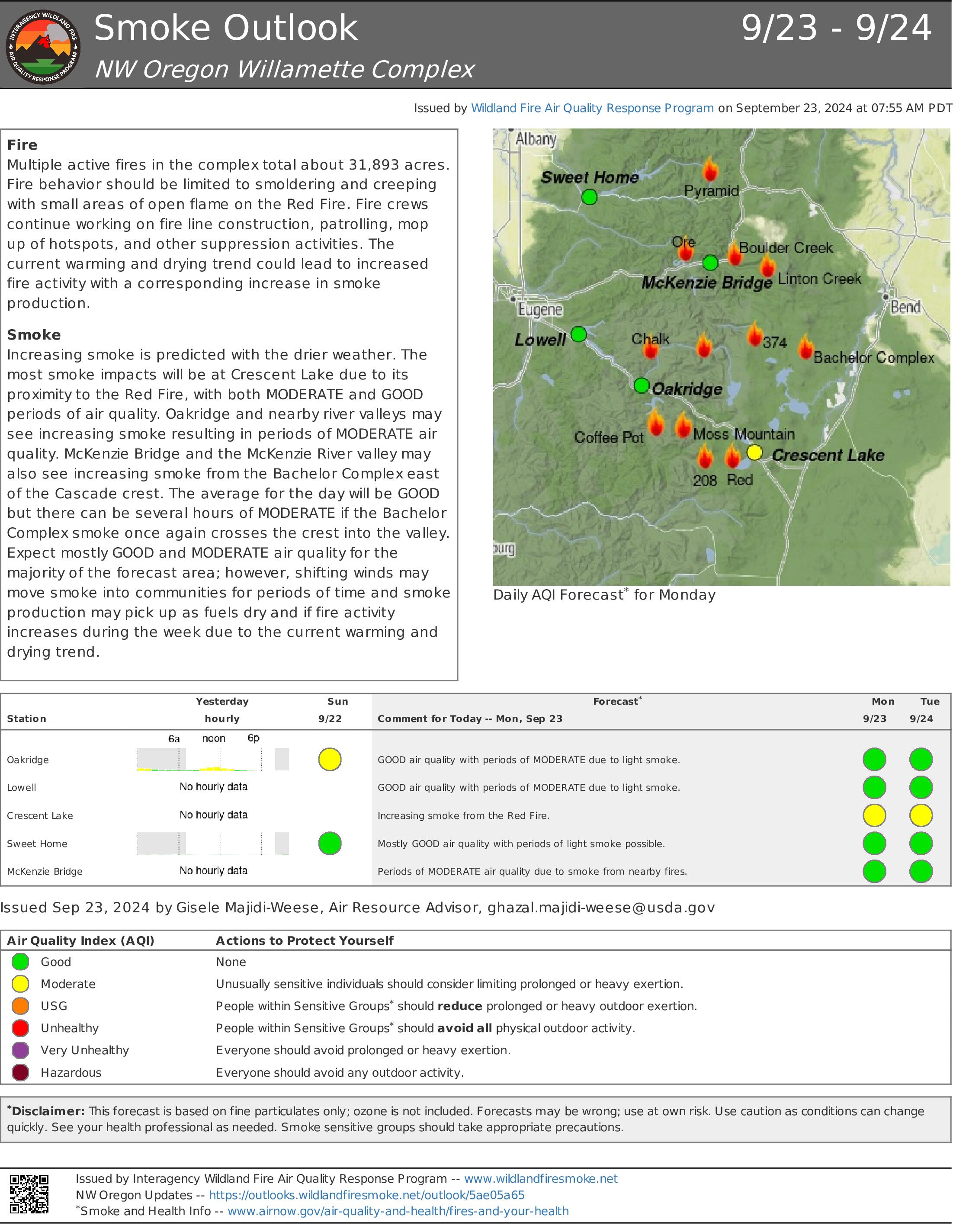
Weather conditions today through Thursday are expected to bring warmer temperatures and lower relative humidity to the fire area. Mixed with the critical fuel conditions there will be an increase in fire activity and smoke coming from the Bachelor Complex fires.
Yesterday at 6 p.m. Northwest Team 3 turned over management of the Bachelor Complex to the Central Oregon Type 3 Incident Management Team, Incident Commander Bob Sjolund. The management of the Flat Top and Firestone Fires returned to the Deschutes National Forest and will be managed by a Type 4 incident commanders.
Bachelor Complex: Critical fuel conditions, warmer temperatures and continued dry conditions contributed to an increase in fire activity and heat on the Little Lava Fire especially in the uncontained fire perimeter on the northern edge near Sheridan Mountain which is in steep and inaccessible terrain. Currently advantageous winds are keeping the northern perimeter in check, and the fire has a low rate of spread as the fire backed north, against the wind and topography. The heavy fuels, such as downed logs, found interior and adjacent to the perimeter of the fire, continue to consume themselves. Isolated torching with some spotting has the potential to grow into short crown runs in the days ahead as more adverse wind conditions are predicted for Tuesday and Wednesday. Along the south side and northeast portion of Little Lava Fire patrol and mop-up efforts are ongoing as crews address areas of heat found near the line. On the east side of Little Lava Fire, in the area of Forest Service Road 45 , firefighters will be patrolling the line looking for any signs of residual heat and mopping up any spots found. On the westside of the fire crews will continue with suppression repair efforts. Elsewhere in the complex the Backside and 911 Fires will be patrolled by air. On incident#846, which is in the Kwohl Butte area and is about three acres, firefighters will complete mop up and patrol today and expect to hike out at the end of shift.
Weather and Fire Behavior: There will be a stronger high-pressure system setting up over the region which will bring warmer and drier conditions to the fire area. On Monday the high temperature will be in the mid-70s with minimum relative humidity around 32% - 37%. Winds will be out of the north-northeast in the afternoon, around 6-9 mph with gusts 15-17 mph. Temperatures continue to rise on Tuesday, with highs in the upper 70s to low 80s, and relative humidity lowering to around 24-28%. Southeast winds on Tuesday morning are expected to shift to the southwest in the afternoon, around 6-10 mph with gusts 15-19 mph. The approaching front has the potential to bring gusty and adverse winds to the fire area ahead of the weather system. This may lead to increased fire activity and short crown runs are possible.
Closures: While evacuations have been lifted, there are two temporary emergency fire closure areas on the Deschutes National Forest. To view the updated closure orders and maps, visit: https://www.fs.usda.gov/alerts/deschutes/alerts-notices.
InciWeb: https://inciweb.wildfire.gov/incident-information/ordef-bachelor-complex-fires
YouTube: https://www.youtube.com/@CentralOregonFireInfo?app=desktop
Fire Information Line: (541) 249-9829, 8:00 a.m. to 8:00 p.m.
Smoke & Air Quality Information: fire.airnow.gov
Final Message for Devils Knob Fire 09 23 2024
Related Incident:
Publication Type: Announcement
While the Type 3 team will continue monitoring and suppression repair work on the Devil's Knob fire, no further perimeter growth is expected, fire activity remains minimal, and there are no further significant daily updates anticipated at this time. For more information on the Devil's Knob fire after today (Monday 9/23), please contact the following:
Tiller Ranger District (also for Forest Closure questions):
Tel: 531-825-3100
Web: https://www.fs.usda.gov/umpqua
Douglas Forest Protective Association:
Tel: 541-672-6507
Web: https://www.dfpa.net/
Williams Mine Fire Area and Road Closure Revised09 18 2024
Related Incident: Williams Mine Fire-GPNF
Publication Type: Closures
Williams Mine Fire: Area and Road Closure
Closure
Date(s): Sep 18, 2024
Forest Order: 06-03-03-24-04 Williams Mine Area and Road Closure
GIFFORD PINCHOT NATIONAL FOREST
Mount Adams Ranger District Trout Lake, Washington
WILLIAMS MINE AREA AND ROAD CLOSURE
Exhibit A: Map of Closure
Pursuant to 16 U.S.C. § 551 and 36 CFR 261.50(a) and (b), the following acts are prohibited on the area described in this order and depicted on Exhibit A, within and/or administered by the Gifford Pinchot National Forest, Mount Adams Ranger District, from September 18, 2024 through December 31, 2024 or until rescinded, whichever is sooner:
1. Going into or being upon the area affected by the Williams Mine Fire (36 CFR 261.52(e))
2. Being on a road. [36 CFR § 261.54(e)].
PURPOSE:
The purpose of this order is to protect public health and safety due to the Williams Mine fire, as well as to allow for safe and efficient firefighting operations.
AREA CLOSURE:
The following description serves as the exterior boundary and closes all lands and roads encompassed within it as depicted in attached Exhibit A:
From a point of beginning on National Forest System (NFS) Road 2300 (posted 23), approximately 3 miles north of Trout Lake, in the southeast corner of Section 33, T7N, R10E; the closure boundary then goes North along 23 to the intersection of Pacific Crest Trail #2000 in the NW Corner of Section PB37, T8N, R9E, and then along the eastern edge of the trail North to the junction of the Pacific Crest Trail #2000 and NFS Road 5603 in the northwest corner of Section 25 T10N R10E; then east on NFS 5603 approximately ½ mile to the eastern boundary of the Gifford Pinchot National Forest (GPNF) in the northwest corner of Section PB47, T10N, R11E; then south along the GPNF eastern boundary approximately 20 miles to the SW corner of Section 33, T7N, R11E; then west along the southern GPNF boundary to NFS Road 2300, to the point of beginning, in the southeast corner of Section 33, T7N, R10E.
The following road surfaces along the Area Closure are open to public traffic, but only to the extent of the graded or surfaced area of the roadway:
- NFS Road 2300 north from its junction with NFS Road 90 south to origin at the southern boundary of the Gifford Pinchot National Forest in the southeast corner of Section 33, T7N, R10E
- NFS Road 5603 from its junction with Pacific Crest Trail #2000 in the northwest corner of Section PB37, T10N, R10E to the eastern boundary of the GPNF in the northwest corner of Section PB47, T10N, R11E.
The following trails surfaces along the Area Closure are open to public traffic:
- The Pacific Crest Trail from Forest Road 8810 to Forest Road 5603.
EXEMPTIONS:
1. Any Federal, State, or County officer, or member of an organized rescue or firefighting force in the performance of an official duty.
2. Persons with Forest Service Permit No. FS-7700-48 (Permit for Use of Roads, Trails, or Areas Restricted by Regulation Order), specifically exempting them from this order.
3. Persons traveling for evacuation purposes.
These prohibitions are in addition to the general prohibitions in 36 CFR Part 261, Subpart A.
Violations of this prohibition are punishable by a fine of not more than $5,000 for an individual or $10,000 for an organization, or imprisonment for not more than 6 months, or both (16 U.S.C. § 551; 18 U.S.C. §§ 3551, 3559, 3571, and 3581).
Executed in Vancouver, Washington, this 18th day of September 2024.
Buck Creek Fire Update 09 23 2024
Related Incident: Buck Creek Fire
Publication Type: News
(Silver Lake, Ore.) – The Buck Creek Fire started in heavy timber within the Yamsay Mountain Semi-Primitive Area on the Fremont-Winema National Forest, about 13 miles southwest of Silver Lake, Ore. The fire spread north and east into managed timber stands on National Forest lands with brush and grass understory and remains about 11 miles from the community of Silver Lake. Warmer, drier conditions have resulted in continued consumption of available fuels well inside the secure containment lines. Increased smoke is expected to continue for several days. Fire managers have planned for this, knowing that allowing these fuels to burn within the fire’s interior will increase their confidence that containment lines will remain secure during forecast wind events and beyond.
Yesterday, firefighters used both aerial and hand-held infrared devices to detect a few areas of heat near the northwest fire line and extinguished these hot spots. Firefighters also used a technique known as gridding to methodically walk an area in a predetermined pattern to locate any lingering heat in the vegetation and mop it up. Chipping operations were conducted along roads used as secondary line northwest of the fire. Mop up efforts in dense pockets of unburned fuels along the southern fire edge continued. Road grading was ongoing on the Forest Road 2804. Backhaul of water handling equipment continued. Overnight, a crew patrolled the perimeter to ensure fire did not cross constructed fire lines.
Today, most activities will continue from the previous day. Using aerial and hand-held infrared heat detection equipment, firefighters will search for hot spots near the established fire line; crews will mop up near established lines and patrol to ensure the lines remain secure. Equipment operators will work on restoring roads, completing suppression repair (pulling in berms and installing water bars) on dozer lines not serving as containment and chipping along roads used as secondary fire line. Firefighters will continue backhauling. Helicopters are available to assist on-the-ground crews as needed.
Weather: Dry and warm weather is expected through Wednesday with high temperatures in the 70s and humidity in the 20s. Light winds will be terrain driven with ridgetop gusts up to 15 mph.
Safety: Firefighting equipment and personnel are present on local roads. For the safety of firefighters and the public, fire managers ask the public to drive carefully and remain clear of the fire areas. The public also plays an important role in preventing the next wildfire by using caution with all ignition sources. For fire prevention tips, visit: https://keeporegongreen.org.
Closures and Restrictions: Fire danger remains high. Campfire and other restrictions are in place within the Fremont-Winema National Forest. A forest closure order is in effect for the area around the Buck Creek Fire. For the complete order and map as well as more detail on fire restrictions, go to: https://www.fs.usda.gov/fremont-winema. Christmas Valley Airport is being used as the helibase for fire operations and is temporarily closed to general aviation. A temporary flight restriction is in place over the Buck Creek Fire.
Smoke: Smoke from fires around the region may affect air quality. For more information on conditions and strategies on limiting exposure, go to: www.oregonsmoke.org or www.AirNow.gov.