
Incident Publication
Rail Ridge and Wiley Flat Fire Daily Update 09 23 2024
Related Incident:
Publication Type: News
Rail Ridge and Wiley Flat Fire Daily Update
9-23-24
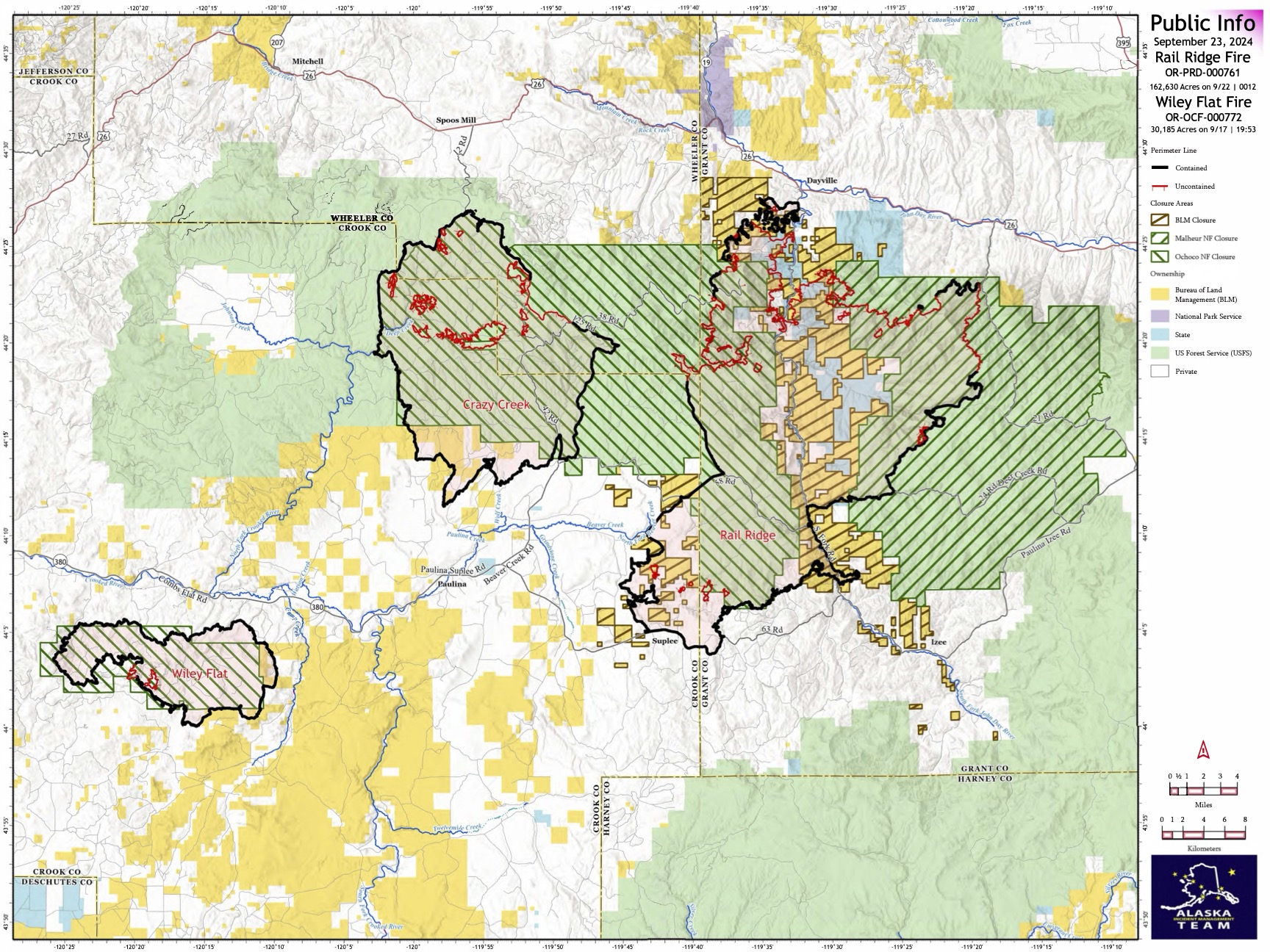
Rail Ridge Fire
Acres: 162,994 - Containment: 56% - Detection Date: Sept 2, 2024 - Cause: Lightning – Total resources: 1,343 - Crews: 41 - Engines: 50 - Dozers: 17
Operational Update
Firefighters are working to increase and strengthen containment lines ahead of elevated temperatures and an increase in winds this week. Crews are focused on confirming the reliability of existing lines and creating depth to increase confidence that these lines will hold with upcoming weather changes. Hotshot crews are engaged in particularly rough terrain around the northern perimeter, working to identify and execute containment line placement that has a high probability of holding in the event of fire growth with weather changes this week.
Wiley Flat Fire
Acres: 30,186 - Containment: 94% - Detection Date: Sept 2, 2024 - Cause: Lightning - Total resources: 138 Crews: 2 - Engines: 3 - Dozers: 2
Operational Update
Nearly 80% of suppression repair work has been accomplished on the Wiley Flat Fire. Firefighters work to establish the last bit of containment and eliminate remaining heat around the perimeter. Crews will remain engaged over the next several days as temperatures go up and winds increase in the fire area, testing containment lines. A Burned Area Emergency Response (BAER) Team will arrive on the Wiley Flat Fire today to assist in suppression repair efforts.
Closures and Evacuations
Rail Ridge Evacuations: All level 1 and 2 evacuation zones have been lifted for Grant County, and level 3 zones have been downgraded to level 2 “set” status.
Wiley Flat Evacuations: All areas inside the fire perimeter are designated Level 3 Evacuation zones. The area encompassing approximately one-half mile from the fire perimeter is designated Level 2 evacuation zone.
For Current Evacuation Levels in Wheeler, Crook and Grant counties, please visit: https://linktr.ee/RailRidgeFire
Closures: The U.S. Forest Service and Bureau of Land Management have implemented closures for the Rail Ridge and Wiley Flat Fires. For more details and closure maps, visit https://linktr.ee/RailRidgeFire
#railridgefire2024 #wileyflatfire2024 #fireyear2024

Homestead Complex and Lane 1 Fire Daily Update 09 23 2024
Related Incident: Lane 1 Fire
Publication Type: News
Email: 2024.homesteadcomplex@firenet.gov
Fire Information Line: 541-208-7100 (Staffed 8 a.m. to 8 p.m.)
Facebook: https://t.ly/mSLvP
Inciweb: https://t.ly/syeHa
September 23, 2024
Firefighters are using direct and indirect tactics to suppress eight fires, totaling approximately 35,735 acres. The Lane 1 fire is 99% contained. The Homestead Complex of fires is 35% contained overall. 730 people are assigned to the Homestead Complex and Lane 1 fires. The goal of these fire suppression and repair efforts is to protect the values at risk: communities and infrastructure; private timber lands; and public resources, including recreation opportunities and fish spawning habitat.
On the Homestead Complex, crews are clearing and repairing roads impacted by the fires and by fire suppression activities. 100 miles of roadside have been chipped with 28 miles remaining, and 68 miles of road have been repaired with 59 miles remaining. For the Lane 1 Fire, 77 miles of roadside have been chipped with 8 miles remaining, and 55 miles of road has been repaired with 38 miles remaining.
Crews are improving containment lines across the fire area by reducing fuels through mastication, chipping wood, and hauling fuels to landings away from the fire. There are still many miles of uncontained fire edge. Firefighters detected additional hot spots and mopped up several areas on the Homestead Complex. Crews have been systematically searching areas and will continue to monitor and mop up as needed.
On the Horse Heaven Fire, firefighter patrols discovered some hot spots in the northwest and northeast sides of the fire which they were able to extinguish. Along the south end of the fire, crews completed hand line work. Road work continues on the 5850 road, on the east side of the Horse Heaven Fire area. On the east flank, crews are grading roads and masticating and chipping fuels. Firefighters used helicopter water drops on some new hot spots.
On the Fuller Lake and Bullpup Fires, a chipper and excavator are working on the 200 and 300 roads on the north flank. On the west flank of the fire, crews are chipping fuels and installing water bars on dozer lines. On the east flank, firefighters are mopping up along the fire edge. Firefighters used helicopter water drops to suppress emerging hot spots.
On the No Man Fire, firefighters are finding and extinguishing a few scattered hotspots. Today, crews are repairing dozer line on the south flank.
On the Lane 1 Fire, crews are digging up and mopping hot spots along dozer fire lines in the north. On the south flank, crews are placing water bars on the Canton Creek Road to improve future drainage. On the 2241 and the 2263 roads, chipping and road repairs are nearly complete, and road grading is underway. About three miles of grading remain in this area. Firefighters are patrolling to identify any emerging hot spots as the weather warms and dries.
Closures and fire restrictions: Two closure orders impact every District of the Umpqua National Forest https://t.ly/Mvn6G. The forest is in Moderate Fire Danger with no Public Use Restrictions https://t.ly/LI4cd. A Bureau of Land Management (BLM) Roseburg District closure order is in effect for portions of BLM land bordering the Umpqua National Forest closure north of Steamboat https://t.ly/uWX6l. A BLM Northwest Oregon District closure is also in place for an area west of the Lane 1 fire https://t.ly/oW1lG.
Weather: Expect warm and dry days in the 70s and 80s with light winds from the east accompanied by a drying trend. Fire behavior is expected to slowly increase as the warm dry weather continues.
Bridge Fire Daily Update 09 23 2024
Related Incident: Bridge Fire
Publication Type: News
Fire Information: (626) 662-0120
Hours: 8:00 a.m. to 6:00 p.m.
Email: 2024.Bridge@firenet.gov
Start Date: September 8, 2024, at 2:12 p.m.
Fire Size: 54,877 acres
Percent Contained: 71%
Personnel: 1,056
Injuries: 5
Structures Damaged: 17
Structures Destroyed: 81
Cause: Under investigation
Location: Sheep Mountain Wilderness, San Gabriel Mountains National Monument
CURRENT SITUATION: Yesterday, additional gains were made in containment as crews completed securing direct and indirect control lines. Today, firefighters will continue mop-up efforts across the fire and strengthen both primary and secondary containment lines. Removal of hazardous trees will also continue, especially in Wrightwood, Grassy Hollow, and near Big Pines Highway. With the increased heat and drier weather, smoke may be visible within interior areas of the fire; crews will investigate the smoke reports and extinguish any isolated heat sources. Work on the southern flank in the Sunset Peak area will focus on further securing fire lines, while crews on the west side of the fire will be completing direct and indirect fire control lines in the Shoemaker Road area, securing the fire edge.
Members of the public returning to fire-impacted areas in and around Wrightwood are asked to return any fire equipment found on their properties to San Bernardino County Fire Station 14 at 5980 Elm St., Wrightwood, Calif., 92397. Please do not take items to Wrightwood Elementary School.
A Forest Order closed portions of the Angeles National Forest on Sept. 21, 2024. The order closing the Bridge Fire area is available in local U.S. Forest Service offices and online at: https://www.fs.usda.gov/angeles.
Damage inspection teams have completed their inspections. Residents affected by the Bridge Fire can find information on the following websites:
For San Bernardino County: prepare.sbcounty.gov/bridge-fire/
For Los Angeles County: recovery.lacounty.gov/bridgefire/
For interactive maps on evacuation zones and status, visit the following websites:
- Los Angeles County: Genasys Protect website or download the app. https://protect.genasys.com
- San Bernardino: https://sbcounty.maps.arcgis.com
For emergency alerts, please register here:
- Los Angeles County: https://ready.lacounty.gov/emergency-notifications/
- San Bernardino County: https://wp.sbcounty.gov/sheriff/alerts/
ROAD CLOSURES:
- Eastbound Big Pines Highway at Largo Vista Road (residents only)
- Big Rock Creek Road at Forest Service Rd. 4N55
- Mescal Creek Road at Mescal Canyon Road
- SR-39 at the base of San Gabriel Canyon (residents only)
- Glendora Mountain Road north of Big Dalton Canyon Road
- Glendora Ridge Road from Mt. Baldy to Glendora Mountain Road
- SR-2 at SR-39
- SR-2 at Flume Canyon Road westbound
Additional closures may still be in place on roads managed and maintained by other agencies inside the forest. Most major roads in the Angeles National Forest are not managed or maintained by the Forest Service. We recommend also checking Caltrans (https://roads.dot.ca.gov/), the Los Angeles County Road Closures list (https://dpw.lacounty.gov/roadclosures/) and the San Bernardino County Road Conditions (https://dpw.sbcounty.gov/operations/road-closures/) list for updates.
WEATHER:
High pressure will build across Southern California through the end of the week, driving the ongoing warming and drying trend, dropping relative humidities, and contributing to elevated fire danger. Daily high temperatures are likely to be 7 to 10 degrees above normal. The warmer, drier weather will likely last through the month's end.
Fossil Complex Daily Update 9232024 09 23 2024
Related Incident: Fossil Complex
Publication Type: News
Suppression Repair is the Main Focus for Crews
FOSSIL, Ore. – On the Fossil Complex, crews are doing final gridding on the Service Fire. This fire has been consolidated into a single division. The fire perimeter will be patrolled throughout the day. Crews are available for initial attack of any new fire starts and responded to a smoke report yesterday.
Suppression repair crews will continue work on all three fire areas - the Fossil Complex, the Lonerock Fire and the Battle Mountain Complex.
Fossil Complex suppression repair is mainly focused on the Service Fire. Crews and equipment will work on the north and south sides of the fire installing water bars and knocking down berms left from dozer lines.
Suppression repair on the Lonerock Fire will be on the east and west sides where there are dozer lines and berms needing repair. Crews are still identifying dozer lines and berms.
The Battle Mountain Complex fires still have a lot of suppression repair work ahead. Crews today will be working in the Monument, Wall Creek, Deer Creek and Middle Fork of the John Day River areas installing water bars, pulling back berms onto the dozer lines, and repairing of cut fence. They will also be identifying additional areas needing repair.
Today’s weather will be in the lower 70s. Winds will continue to be light out of the west and relative humidity in the mid 30s.
Videos: Recordings of the Daily Operations Updates and other stories are available at: https://www.youtube.com/@FossilComplex.
Morning Update Frog Fire Monday 09 23 2024
Related Incident: Frog
Publication Type: News
Frog Fire Statistics
- Size: 3,112 acres
- Containment: 42%
- Total Personnel: 85
- Location: east of Clayton, ID
- Reported: September 7, 2024
- Cause: Lightning
For More Information
- InciWeb: https://inciweb.wildfire.gov/incident-information/idstf-frog
- Facebook: https://www.facebook.com/sawtoothnationalforest
Current Situation: Increase in fire activity occurred on the Frog Fire yesterday, and helicopters were again used to drop water in areas difficult for fire crews to successfully work in the steep terrain. A crew has begun working from the existing containment line on the east side of the fire towards the west. While additional containment has not yet been verified yet, the crews are successfully limiting fire spread. Additional crews have been ordered with in the intent of have them work along the northwest edge of the fire, above Big Boulder Creek to prevent the fire from spreading further north.
Fire personnel continue to work in the East Fork drainage. They are evaluating the fire situation and are prepared to respond as needed to any sudden change in fire activity or intensity. Aerial surveillance of the incident has included drones capable of infrared readings to evaluate areas with the most potential for fire activity. These operators are also working from the roadways near the fire.
Evacuations: There are currently no evacuations related to the Frog Fire.
Closures: The area closure in place around the Frog Fire has been amended and now excludes FS Roads 669 and 670 and Trail 682. FS Road 667 remains closed as does Trail 047 adjacent to the closure boundary. Hunters and recreationalists should familiarize themselves with this closure information prior to entering the vicinity. Please reference the map and read the full closure description at https://inciweb.wildfire.gov/incident-closures/idstf-frog.
Airport Fire Incident Update 09 23 2024
Related Incident:
Publication Type: News
Location: Trabuco Canyon, CA
Personnel: 1118
Start date: 09/09/24 1:00 p.m.
Cause: Human
Size: 23,519
Percent contained: 81%
For a printable version of today's complete update for the Airport Fire, please see the related link below.
Containment percentage continues to rise on the Airport Fire. Fire managers are confident 81 percent of the fire perimeter is secure. Drones with infrared technology will be used today to check for heat in drainage areas with heavy vegetative debris that may be holding heat. Ground crews or air resources will then be deployed to confirm and address any areas of concern.
Back hauling of equipment and other items is a priority as unified command prepares to transition the Airport Fire to a Type 3 Incident Management Team that will be based out of the Cleveland National Forest tomorrow.
Suppression repair crews continue to tidy up dozer lines and other areas disturbed by fire suppression activities. A Burned Area Response (BAER) Team has also arrived to begin assessing watersheds that may have been impacted by fire activity. The team will study potential changes in water runoff and how it may affect waterways, communities, aquatic wildlife and any other identified areas of concern. As the study continues, mitigation processes will begin.
A closure order is in effect for the Trabuco Ranger District of the Cleveland National Forest. Firefighters have observed hikers and mountain bikers in the area. Please do not enter the closure area or recreate on any of the firelines constructed for the incident. https://www.fs.usda.gov/alerts/cleveland/alerts-notices/?aid=90727
Notice: Southern California Edison Electric Utility Company has announced plans to replace damaged power poles and lines beginning Tuesday along Ortega Highway. Helicopters will be used to transport and place poles. Operations will be scheduled during times of minimal highway use. However, all motorists should be aware that traffic delays can occasionally occur for extended periods. Please plan accordingly.
Diamond Complex Update 09 23 2024
Related Incident:
Publication Type: News
Current Situation: The Diamond Complex includes 33 fires in the Umpqua National Forest, 31 of which are 100% contained. Favorable weather conditions have allowed personnel to nearly complete fire-suppression repair tasks across the Diamond Complex. While fire-suppression repair remains the incident priority, personnel and equipment are also poised to ensure all fires stay within containment lines and are ready to respond to any new fires on Umpqua National Forest lands within the vicinity of the complex.
The Pine Bench Fire has increased to 74% containment. The remaining uncontrolled portion of the fire is in the Boulder Creek Wilderness. Because the fire has not grown outside its current footprint in several weeks and future growth is not anticipated, firefighters are monitoring it by reconnaissance flights. All suppression repair has been completed around the Pine Bench Fire, and resources have been relocated to other portions of the complex.
The Potter Fire has increased to 98% containment with most of the suppression-repair efforts completed. Crews have been working diligently to repair dozer- and hand-constructed control lines, grade roads, and repair creek crossings. Chippers continue to process large amount of slash generated during hazard tree removal. A contingent of equipment has been repairing roads and culverts that have been damaged by fire equipment throughout the tenure of the incident.
The suppression repair process is a vital piece of bringing the forest back to a condition that will be safe for visitors and residents while also preventing soil erosion and damage to streams and waterways. Personnel continue to work together with forest resource advisors to ensure that this rehabilitation is completed appropriately with long-term benefits to the forest.
Over the past week, the incident has slowly started releasing crews and equipment as projects are completed and the threat of fire growth has subsided. Over the coming days, incident management personnel will continue this trend of downsizing as a majority of the fires within the Diamond Complex are fully contained with suppression repair operations completed.
Forest Closure: Umpqua National Forest lands, roads, and trails around the Diamond Complex fires are temporarily closed (with several exemptions) under Forest Order 06-15-24-07. You are responsible for knowing where you are in relation to the closed areas, so be prepared and view the order and map prior to recreating on your public lands.
Fire Restrictions: The Umpqua National Forest has terminated Public Use Restrictions (PURs) and has decreased to Moderate Fire Danger across all districts. As of 12:01 a.m. today, September 23, 2024, the forest has moved to Industrial Fire Precaution Level (IFPL) 1.
Size: 11,141 acres
Containment: 90%
Personnel: 276
Resources: 5 crews | 1 helicopter | 10 engines | 3 dozers | 10 water tenders | 2 masticators | 5 excavators
###
Next update to be released 9-25-2024
West and Preacher Fires Update 09 23 2024
Related Incident: 2024 - West Fire - TNF2024 - Preacher Fire - TNF
Publication Type: News
Ignitions on West Fire near completion, Preacher Fire 100% contained
Highlights/Operations: Firefighters near the end of ignition work around the southwest corner of the West Fire. After several days of mop up, the area around Camp Geronimo was considered contained.
Yesterday, aerial ignitions continued interior to the perimeter and west of the 218 road with the goal of improving some unburned islands. Elevated winds reduce aerial ignition effectiveness, but crews made progress with hand ignitions east of Pine and along the Control Road towards State Route 87. Initially plans were to hold fire along the fuels treatment block just east of the dozer line, but weather and fire behavior aligned and have allowed crews the ability to capitalize on igniting down to the dozer line, we are taking advantage of an opportunity now to create defensible space that will help keep homes, businesses and private property safer from future wildfires.
Today firefighters will continue any remaining ignitions needed from Shannon Gulch to the west and on the upper side of the thinned forest area east of Pine. Crews working on the east side of Pine and just north of the Control Road connect their fire in the southwest corner of the perimeter along the hiking trail system. Firefighters with chainsaws are also removing dead trees along the Webber Road that could be a future hazard to the public. Across the rest of the fire, engines are patrolling, extinguishing heat from the ignitions last night and backhauling equipment. As Southwest Incident Management Team 3 nears day 21, the team has begun to transition to a new fire management organization that will assume command of the fire in the coming days.
The Preacher Fire is now 100 percent contained. The area is still being patrolled to check for any remaining smoke.
Weather: Temperatures are predicted to be warm and dry Monday and Tuesday. Highs in the upper 70s to upper 80s both days. Minimum relative humidity levels will average 20 to 30%. Winds are light from the north and northwest.
Safety: A Temporary Flight Restriction (TFR) is in place over the West fire area, which includes uncrewed aircraft systems or drones. Reminder that if you fly we can’t, unauthorized drone flights pose serious risks to firefighter and public safety and the effectiveness of wildfire suppression operations.
Closure: The Tonto National Forest has issued a closure for land surrounding the West Fire, this includes Pine Trailhead.
Evacuations: Pine residents on the east side of SR 87 and east of North Pine Creek Canyon road are in SET status. Geronimo Estates residents near the West Fire are in SET status. An interactive map is available to stay up to date with evacuation levels related to both the West and Preacher Fires:
Receive emergency notifications from Gila County.
Smoke: During ignitions, smoke may settle in low-lying areas overnight. Residents are encouraged to close windows at night to avoid smoke impacts. Talk with your doctor and plan for how to manage your health conditions when it is smoky. Additional resources for how to prepare for wildfire smoke.
For the latest news and information about the Tonto National Forest, follow along on Facebook @TontoNationalForest, ‘X’ (formerly Twitter) @TontoForest or Instagram @tontonationalforest and on the Tonto National Forest website.
Wapiti Fire Update Monday 09 23 2024
Related Incident:
Publication Type: News
Wapiti Fire Statistics
- Size: 125,478 acres
- Completion: 72%
- Total Personnel: 311
- Location: near Grandjean, ID
- Reported: July 24, 2024
- Cause: Lightning
For More Information
- InciWeb: https://inciweb.wildfire.gov/incident-information/idbof-wapiti-fire
- Facebook: https://www.facebook.com/wapitifireinfo2024
- Linktree: https://linktr.ee/WapitiFireInfo2024
- Interactive Map: https://tinyurl.com/WapitiFireInfoMap
Special Updates: As a result of fire suppression efforts and vegetation removal, numerous trees have been cut into lengths suitable for firewood. Entering the fire closure to collect firewood is prohibited. The public may collect any firewood available outside of the closure with a valid firewood permit. Please direct questions on firewood collection to the Stanley Ranger Station at 208.774.3000.
Weather: Yesterday’s fall weather was reminiscent of what will continue for the early part of the week. Wednesday, a chance of storms will enter the area. The chances for measurable precipitation are marginal. Fire managers will be particularly attentive to increases in wind speed which could lead to not only increased fire behavior but also cause burned and fire-weakened trees to fall.
Current Situation: Continued warm and dry weather is drying out grass and brush within the Wapiti Fire and allowing smolder embers to grow into more active fire. This has not led to any concerns of additional fire spread, as most of the activity is occurring within the existing fire perimeter. However, firefighters are continuously patrolling the fire area, including via aerial reconnaissance, and will quickly respond to any areas that may require direct suppression actions. Most of yesterday’s visible smoke and flames were near Warm Springs and Cape Horn Ridge.
The Incident Management Team has updated mapping to show all areas where the fire is contained or suppression actions have been completed. Fire perimeter is only called contained or completed when there is strong assurance that the fire will not continue to grow beyond its current location. Among the areas now reflected as contained on the map are the portions north of Highway 21 within the Stanley Basin.
Removal of hazard trees continues near Stanley Lake, with larger logs being set aside for later firewood collection and smaller trees and limbs being processed with a chipper and distributed through the area. Large equipment is almost done repairing the dozer line constructed near Homestead Creek. Once that work is completed, the equipment will be transferred to work in other areas of the fire, including the Grandjean road repair.
Travelers along Highway 21 should drive cautiously, with lights on, and be prepared for periodic closures or pilot car usage. Along with firefighters, Idaho Transportation Department (ITD) continues to work along the roadway. The speed limit has been lowered to 45 mph between mile marker 92 and Banner Summit.
Evacuations: Evacuation status for Stanley Zone 1 is currently at READY. Stanley Zones 2 – 5 and Kasino are no longer in an evacuation status. Sign up for Custer County CodeRED emergency notifications: text CUSTER to 99411 or enroll at https://public.coderedweb.com/CNE/BF28E45537FF.
All Boise County evacuation levels have been lifted; residents should remain alert for any change in conditions which could reinitiate an evacuation status. Sign up for Boise County Alert Sense emergency notifications at https://public.alertsense.com/SignUp/publicUser.aspx?regionid=1163.
For evacuation information on the Wapiti Fire, please see the Custer County Sheriff’s Facebook page, https://www.facebook.com/p/Custer-County-Sheriff-Idaho-61558947312289/, and the Boise County Sheriff’s Facebook page, https://www.facebook.com/boisecountysheriff/.
Closures: The Wapiti Fire area closure covers portions of the Sawtooth, Boise, and Salmon National Forests. Please reference the map and description at https://inciweb.wildfire.gov/incident-closures/idbof-wapiti-fire. Recreationalists and hunters should reference this map and obey all posted signage regarding the closure area and any related road, trail, and campground closures.
An interactive map for all closures on the Boise National Forest is found at https://experience.arcgis.com/experience/642380b0eb124c8cab6bd9ad3d7146ad/page/Overview/#data_s=id%3AdataSource_5-1888bd00a2c-layer-13-1888bd00b53-layer-16%3A82.
Lava Fire Daily Update September 23 2024 09 23 2024
Related Incident:
Publication Type: News
A Community Meeting will be held in Indian Valley on Tuesday, September 24th at 7:00 p.m. at the Indian Valley Community Hall, 803 Indian Valley Road, Indian Valley, Idaho.
As a reminder, on the Boise National Forest, Snowbank Road and the Sage Hen Reservoir area remain closed. In Gem County, the following roads are closed: Third Fork Road at Nesbitt Lane, Second Fork Road at Nesbitt Lane, and Nesbitt Lane. The Sweet-Ola Highway is closed at the High Valley intersection in Ola. Please be advised that the Gem County Sheriff’s Office is staffing the road closure check points.
The Rocky Mountain Complex Incident Management Team 2 is arriving to transition with the Southern Area Read Team. The Rocky Mountain Team will join command of the fire on Wednesday, September 25th.
Overview: The Lava Fire is on the Boise and Payette National Forests and lands administered by the Bureau of Land Management and the Idaho Department of Lands. The fire is located north of Emmett and west of Lake Cascade and started by lightning on Monday, September 2. It is burning in tall grass, brush, and timber.
The Lava Fire is currently 97,844 acres with 65 percent of the perimeter contained. 658 personnel are assigned, including 13 crews, 1 large helicopter, 1 small helicopter, 25 engines, 9 bulldozers, 13 water tenders, 7 excavators, 1 skidder, 8 masticators, 4 graders, and 7 ambulances.
Property remaining in an area that is evacuated or impacted by Forest Service closures must remain until fire managers, Sheriff’s departments, and emergency management departments deem the area is safe for reentry.
Operations: Yesterday, a new fire start was identified south of the West Mountain Complex Incident Command Post located south of Cascade, Idaho. Lava Fire air and ground resources assisted with initial attack, in collaboration with Idaho Department of Lands, Southern Idaho Timber Protective Association, and the Boise and Payette National forests.
On the eastern flank, repair of handline and dozer line continued. Crews repaired most of the dozer line in the southeastern portion the fire and conducted mop of heat within 150 feet of containment lines.
Hand crewscontinued building containment line directly along the fire edge in the northern flank from Little Weiser River working east and to Anderson Creek and working west from Forest Service Roads 835 to 766. Mop up continued around homes near Grays Creek and within 50 feet of containment lines.
On the western flank, mop up and suppression repair of interior dozer lines continued. Firefighters removed 10,000 feet of hoseline.
Firefighters continued constructing direct and indirect line along Forest Service Road 653 on the southern flank. Near the Gross community, crews continued mop and patrol 150 feet from containment lines.
Today, firefighters will continue to extinguish isolated pockets of heat, focusing on a depth of 150 feet from containment lines. Suppression repair work on containment lines as well as interior bulldozer lines will continue.
On the eastern flank, chipping will reduce thick, burnable vegetation on Forest Service Roads 446E and Gopher Road. Crews will patrol Forest Service Road 404 and extinguish any heat sources they find, focusing on a depth of 150 feet from the line. Firefighters will repair handlines and bulldozer lines, remove equipment, and assess equipment needs such as road repair graders.
On the northern flank, crews continue to build direct handline southwest along the fire edge towards Anderson Creek and mop up will continue as needed. On Forest Service Road 206, crews will remove hazard trees.
On the western flank, crews will extinguish heat along containment lines from Forest Service Road 208 to road 214. Firefighters will continue to repair containment line and interior bulldozer lines.
On the southern flank, firefighters will continue to patrol and mop up any fire activity near the Gross community. Chipping will occur on National Forest Road 625 and at the Third Fork Cabin. Hand crews will continue identifying heat and improving hand line along Forest Service Road 653.
Weather/Fire Behavior: Fair conditions continue. Cloud cover from the weak weather system that came into the area on Sunday is expected to clear throughout the day. As cloud cover reduces, temperatures are expected to increase to the upper 60s or low 70s. As the system departs, winds may pick up to 5 to 9 mph with gusts up to 18 mph. In the next several days, temperatures are expected to rise and with it the potential for fire spread including single tree torching.
Evacuations: Adams County Sheriff’s Office downgraded to a Level 1 “READY” for residents south of South Grays Creek, along Little Weiser River Road in Indian Valley, North of South Grays Creek Road to Highway 95, and the Mesa Area.
Valley County Sheriff’s Office removed Zones 2 & 3 from LEVEL 1 “READY” status. Zones 4 – 6 remain in a LEVEL 1 “READY” Evacuation notice.
Closures and Restrictions: The Boise and Payette National Forests implemented a joint Lava Fire Area, Road, and Trail Closure for public and firefighter safety. The southern portion of this closure area follows roads 601 (which remains closed) and 644 (which remains open). The northern boundary follows a portion of the Payette National Forest’s road 186 (open) and crosses over to the Boise National Forest just south of trail 116. Snowbank Road (446) and Sage Hen Reservoir area remain closed, French Creek Campground remains open. This closure adjustment became effective on September 19, 2024, at 10:00 a.m.
Gem County Road and Bridge issued the following road closures: Third Fork Road at Nesbitt Lane, Second Fork Road at Nesbitt Lane, and Nesbitt Lane. The Sweet-Ola Highway is closed at the High Valley intersection in Ola. Please be advised that the Gem County Sheriff’s Office is staffing the road closure check points.
A temporary flight restriction is in effect in and around the fire area. This includes the use of personal drones. If you fly, we cannot fly.