
Incident Publication
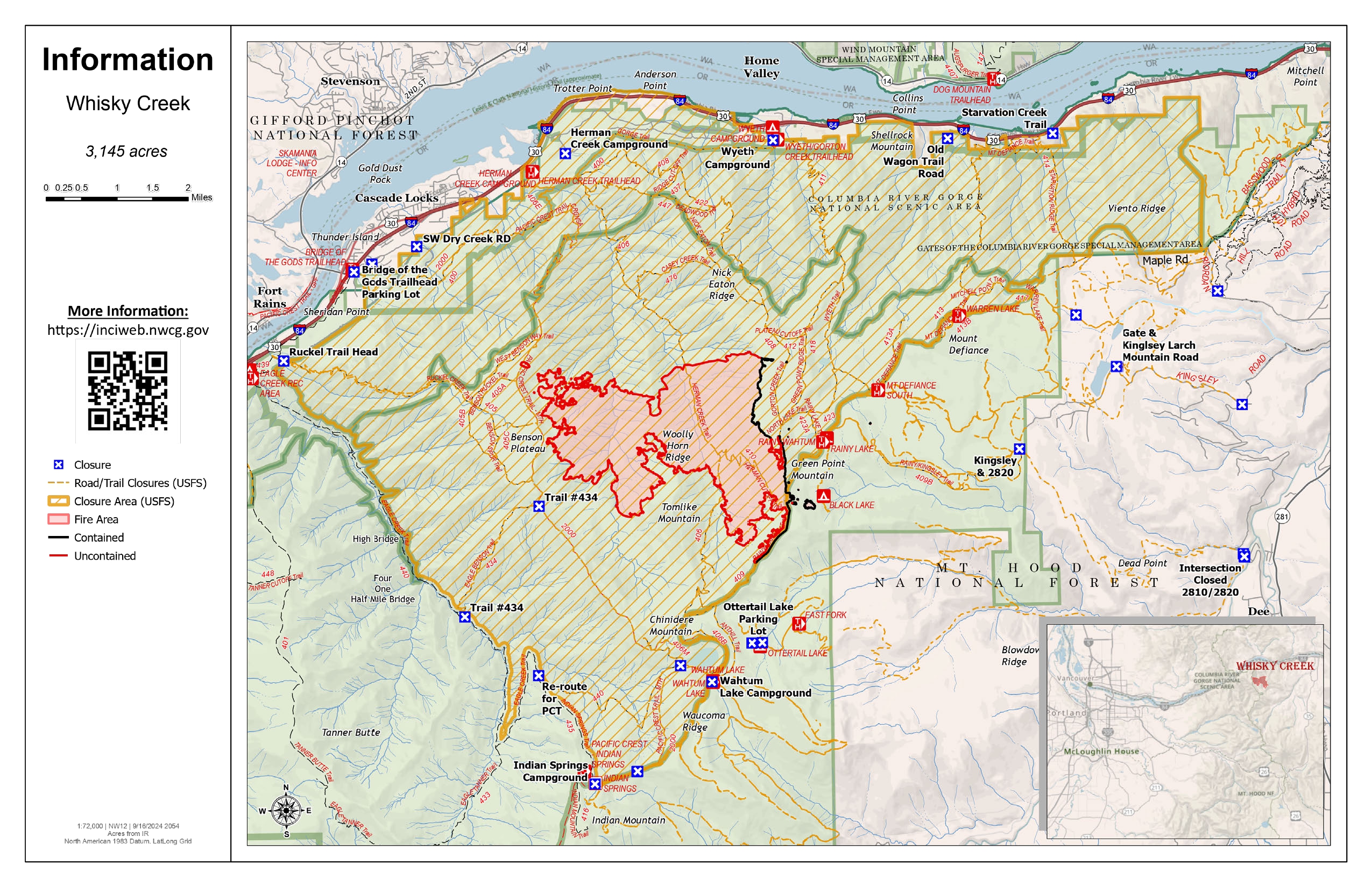
Whisky Creek Fire update 09 22 2024
Related Incident: Whisky Creek Fire
Publication Type: News
Whisky Creek Size: 3,169 acres | Start Date: July 20 | Cause: Human | Containment: 25%
Total Resources: 72 | Hand Crews: 2 | Engines: 2 | Water Tenders: 2 | Heavy Equipment:2
The Whisky Creek Fire is in steep and rugged terrain within the Mark O. Hatfield Wilderness in the Mt. Hood National Forest. The fire remains within the control lines along the southern and eastern edge. The Eagle Creek Fire scar continues to be a barrier along the western and northern edges of the fire.
The fire continues smoldering in needle-cast and heavy logs. Yesterday’s weather provided higher temperatures and light easterly winds, but firefighters did not see a significant increase in fire activity. Today and tomorrow are also predicted to be warm and sunny, but fire activity is anticipated to remain minimal with little growth. Smoke will continue to be seen from Hood River Valley and the Columbia Gorge.
Yesterday, crews finished grading Forest Road 2820 and made significant progress grading Forest Road 2810. Repair work on Forest Trail 409B has been completed. With guidance from Resource Advisors, firefighters will start repair work on the helispot that was created in the wilderness above Rainy Lake during fire suppression efforts.
This will be the last daily update for the Whisky Creek Fire. Updates will be released in the future as needed to advise the public of changes in fire activity and closures. Fire personnel will continue to patrol and monitor the fire, extinguish hot areas threatening the control lines where they can safely engage, and repair damage from suppression work.
Closures: Area closures remain in the Mt. Hood National Forest, Columbia River Gorge National Scenic Area, and Hood River County. As repair work is completed on the roads and trails affected by the fire, Agency Administrators will work with fire personnel to reassess the fire closure area. Closures are put into place for the safety of the public and fire crews; intrusion into a closure area can disrupt fire suppression and repair activities, endanger lives and property, and can result in fines. Closure information is at: https://linktr.ee/whisky_creek.2024.
Smoke: With the incoming warmer weather and light east winds over the next few days, we expect the fire will continue to produce light to moderate smoke. Based on minimal fire activity over the last two weeks, there is no expectation that the fire will move outside it’s current footprint. For smoke forecasts and safety, visit: oregonsmoke.org.
Safety: The public plays an important role in preventing the next wildfire; please use caution with all potential ignition sources. For prevention tips see: https://keeporegongreen.org.
Willamette Complex South Daily Update for Sunday 09 22 2024
Related Incident: Willamette Complex Fires - South
Publication Type: News
Willamette Complex South & Red Fire Update
Red, 208, Moss Mountain, Coffee Pot, Tire Mountain, McKinley Creek and Chalk Fires
Date: Sunday, September 22, 2024
Fire Causes: Lightning
Email: 2024.willamettecomplex@firenet.gov
Information Phone Line: 541-208-1742
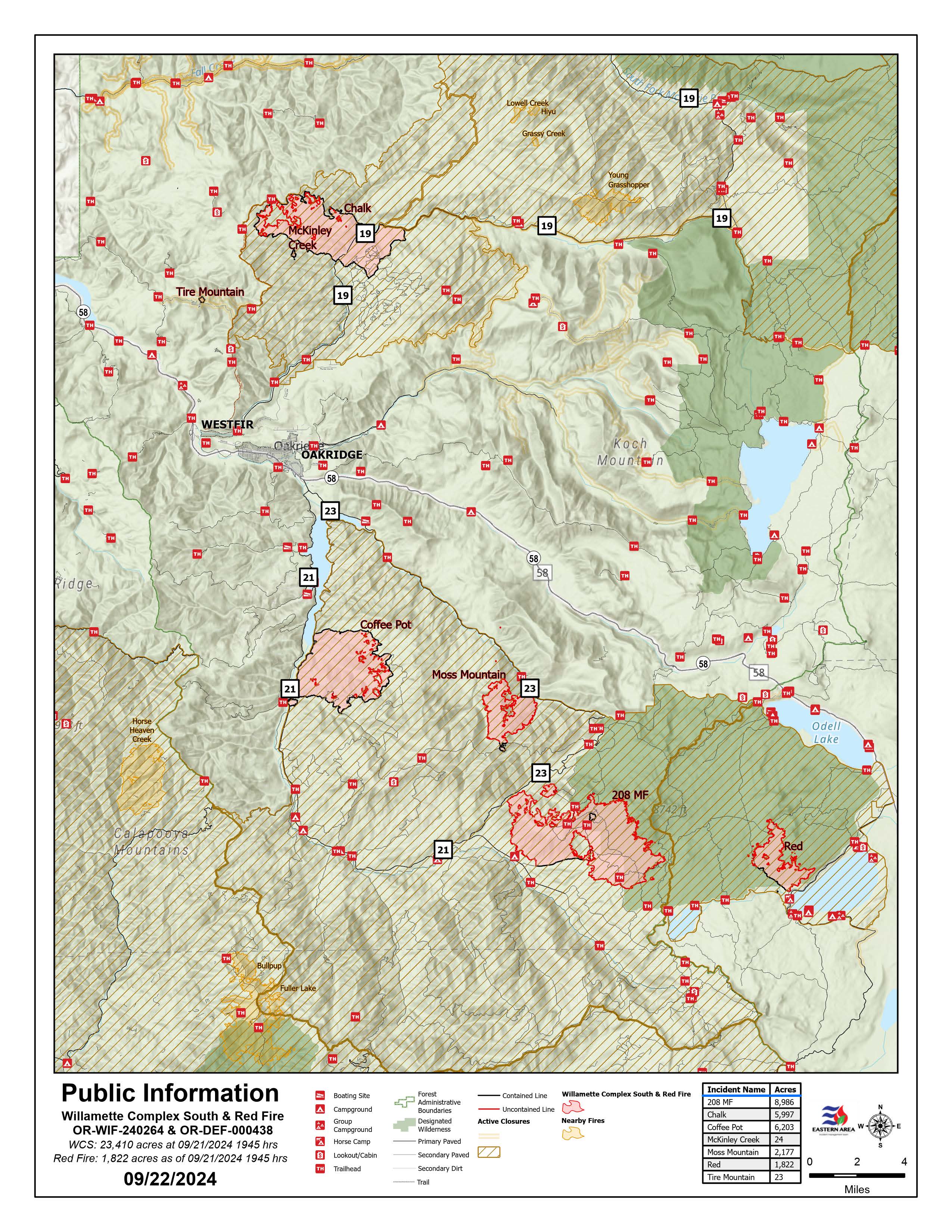
Willamette Complex South: Total Personnel: 414 | Total Willamette Complex South Acres: 23,400
InciWeb: https://inciweb.wildfire.gov/incident-information/orwif-willamette-complex-fires-south
Facebook: https://www.facebook.com/WillametteComplexFires/
Red Fire: Total Personnel: 50 | Total Red Fire Acres: 1,805
InciWeb: https://inciweb.wildfire.gov/incident-information/ordef-red-fire
Facebook: https://www.facebook.com/2024RedFireOR/
Summary
The Incident Management Team is assessing long-term strategies for the seven-fire complex. Much of that involves chipping, slash removal, road repair and bolstering containment lines. Fire growth has been minimal of late, but conditions are changing and that may affect fire behavior. Crews have been successful at keeping fire within established containment perimeters. Crews continue working to firm up indirect control lines and repair resources in places impacted by suppression operations. The situation at each fire will be closely monitored as we head into next week.
The Chalk Fire, Coffee Pot Fire, McKinley Creek Fire, and Tire Mountain Fire remain 100% contained and in monitor-and-patrol phase. There has been limited open flame and torching on the Chalk Fire. Crews are clearing brush and repairing roads used by fire crew vehicles and heavy equipment. Operations are designed to be scientifically sound and protect sensitive terrain and vegetation as much as possible. Resource specialists are assisting in plan development. Members of the public are asked to continue respecting area closures and restrictions which may change due to weather conditions and fire behavior. Forest leadership continue to evaluate and will adjust closures when it is safe to do so.
Red Fire (1,805 acres, 11% containment)
The Red Fire is 11% contained. Hauling and removal of slash from Forest Service Road (FSR) 6010 from Summit Lake to the southwestern corner of Crescent Lake remains a priority. Road repairs and clean-up of the shaded fuel break from Whitefish Horse Camp to Crescent Lake Sno-Park continues. Structure protection measures will remain in place, given the shift to warmer, drier weather. Fire growth remains minimal, moderately paced, and concentrated on the southeast perimeter of the fire. Additional fire crews are moving into the area with the anticipated warmer and drier air forecast for the next few days.
208 Fire (8,979 acres, 4% containment)
There were some puffs of smoke observed near the northwest corner. Crews will continue improving holding lines from Lighthouse Rock to Summit Lake. Road repair and material chipping operations are ongoing from Campers Flat to Emigrant Butte along FSR 21.
Moss Mountain Fire (2,175 acres, 10% containment)
Slash and excess vegetation removal along primary lines northeast of Groundhog Mountain is nearing completion, and some heavy equipment operations are being conducted there. Crews are making progress south of Beach Mountain near FSR 2316 and expect to connect to the existing fire-line along FSR 23 from the 208 Fire.
Weather and Fire Behavior
The passing cold front has run its course, so the brief boost in relative humidity is giving way to higher temperatures and a reduction in relative humidity levels. Temperatures are returning to seasonal averages, with lows in the 40s and highs in the mid-60s. Those temperatures may warm into the low 80s Tuesday or Wednesday with the arrival of another front. Expect light northwest winds and a drop in minimum relative humidity levels to 20 – 30%. Heavy fuels have been burning out, but smoldering and creeping continue.
Closures, Fire Restrictions, and Evacuations
- For closure information, visit: https://tinyurl.com/RedFireClosures2024 & https://tinyurl.com/WillFireClosures2024.
- For fire restrictions, visit: https://tinyurl.com/DesFireRestrictions2024 & https://tinyurl.com/WillFireRestrictions2024.
- The Level 1 – BE READY to Evacuate notice remains in effect for the Red Fire. For more information or to sign up for alerts, visit: www.klamathcounty.org/300/emergency-management.
Homestead Complex and Lane 1 Fire Daily Update 09 22 2024
Related Incident: Lane 1 Fire
Publication Type: News
Email: 2024.homesteadcomplex@firenet.gov
Fire Information Line: 541-208-7100 (Staffed 8 a.m. to 8 p.m.)
Facebook: https://t.ly/mSLvP
Inciweb: https://t.ly/syeHa
September 22, 2024
Firefighters are using direct and indirect tactics to suppress eight fires, totaling approximately 35,721 acres. The Lane 1 fire is 99% contained. The Homestead Complex of fires is 35% contained overall. 766 people are assigned to the Homestead Complex and Lane 1 fires.
Crews are improving containment lines across the fire area by reducing fuels through mastication, chipping wood, and hauling fuels to landings away from the fire. There are still many miles of uncontained fire edge. Aerial infrared detection yesterday located additional hot spots that crews will address today. Firefighters are mopping up: widening and strengthening fire lines by extinguishing hot spots and removing fuels. Crews are also clearing and repairing roads impacted by the fires and by fire suppression activities. The goal of these fire suppression and repair efforts is to protect the values at risk: communities and infrastructure; private timber lands; and public resources, including recreation opportunities and fish spawning habitat.
On the Horse Heaven Fire, a masticator is working north on the 3829 road, with a crew chipping and removing brush behind. A crew hiked in from the southwest to evaluate hoses and pumps and determine how to remove any unneeded equipment. On the north flank, firefighters continue checking on hot spots. Infrared mapping shows no additional hot spots in that area. On the east flank, crews are grading roads and masticating and chipping fuels.
On the Fuller Lake and Bullpup Fires, a chipper and excavator are working on the 200 and 300 roads on the north flank. On the west flank of the fire, crews are chipping fuels and installing water bars on dozer lines. On the east flank, firefighters are mopping up along the fire edge. There was debris from a slide blocking the 3810 road that a dozer removed yesterday to restore access. A type 1 helicopter dropped water at the southeast fire edge yesterday to keep the fire in check.
On the No Man Fire, infrared detection showed heat near the finger on the west flank within 100 yards of the fire line. Firefighters yesterday took care of it. Today, crews are repairing dozer line on the south flank. They are using an excavator to scatter vegetation and close fire lines and old road beds near Chilcoot Mountain.
On the Lane 1 Fire, an engine and crew addressed a pocket of heat yesterday near the northeast edge. At the south flank, crews are placing water bars on the Canton Creek Road to improve future drainage. On the 2328 road, chipping and road repairs are nearly complete and road grading will start today. Firefighters removed unneeded structure protection equipment from the Bohemia Mine District yesterday.
Closures and fire restrictions: Two closure orders impact every District of the Umpqua National Forest https://t.ly/Mvn6G. The forest is in Moderate Fire Danger with no Public Use Restrictions https://t.ly/LI4cd. A Bureau of Land Management (BLM) Roseburg District closure order is in effect for portions of BLM land bordering the Umpqua National Forest closure north of Steamboat https://t.ly/uWX6l. A BLM Northwest Oregon District closure is also in place for an area west of the Lane 1 fire https://t.ly/oW1lG.
Weather: Today’s predicted forecast at 3,500 feet is a high of 72 degrees with 31 percent relative humidity. Tomorrow’s high temperature is predicted to be 75 degrees, and it will reach 83 degrees on Tuesday. As fuels dry out, there is increased potential for some fire spread and additional smoke. Wednesday starts a cooling trend, with higher humidity, but there is no rain in the forecast.
Airport Fire Incident Update 09 22 2024
Related Incident:
Publication Type: News

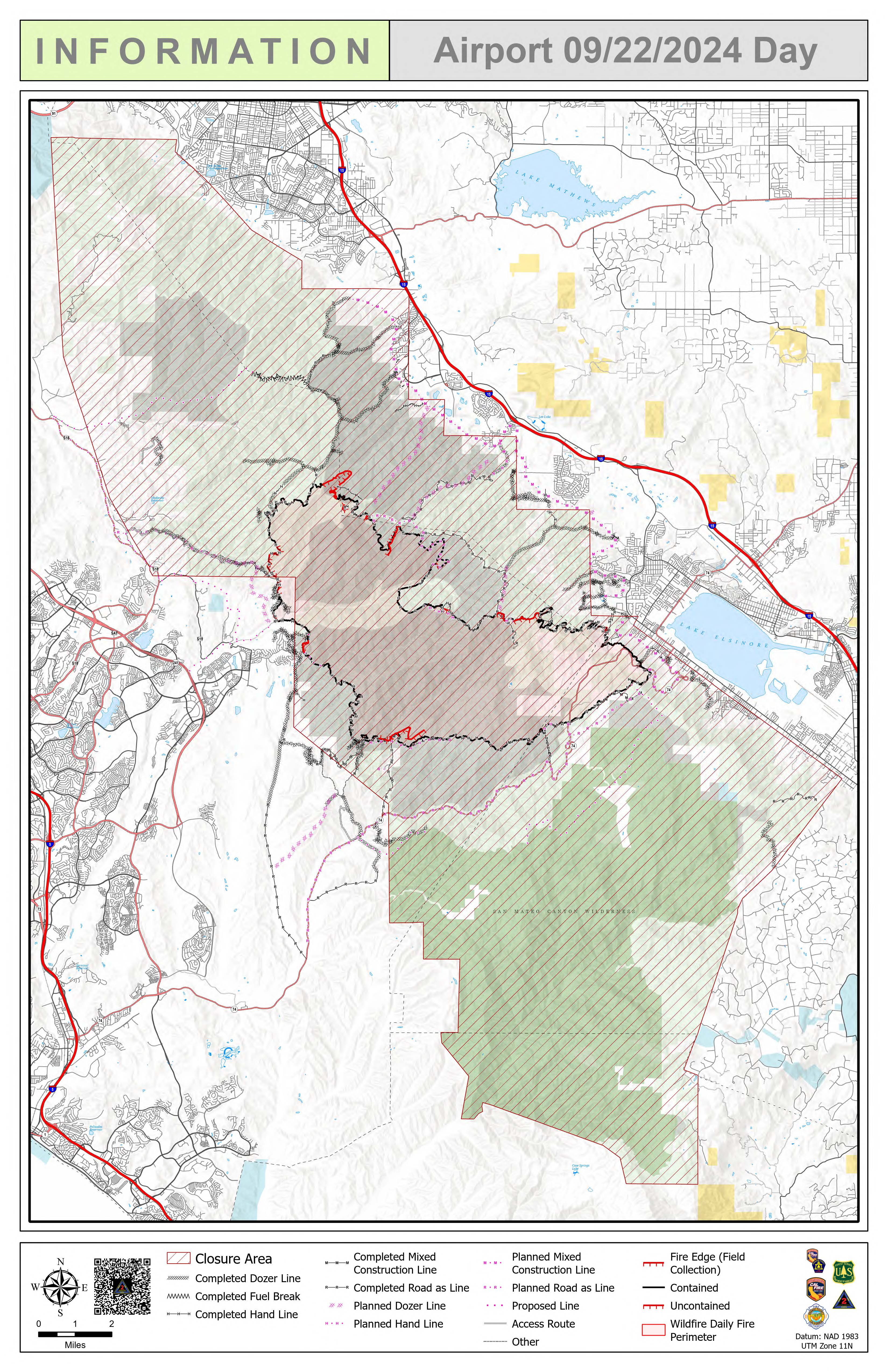
Location: Trabuco Canyon, CA
Personnel: 1189
Start date: 09/09/24 1:00 p.m.
Cause: Human
Size: 23,519
Percent contained: 74%
For a printable version of today's complete update for the Airport Fire, please see the related link below.
Firefighters are working diligently to complete fireline tasks amidst warmer temperatures, drying
vegetation and anticipated shifting winds this afternoon from the Lake Elsinore Effect.
Heat sources are scarce around the fire perimeter but, pockets of heat in duff and leaf litter remain in some
areas. Drones equipped with infrared technology are being used to assist crews in locating hot spots in
unforgiving terrain.
Suppression repair is occurring simultaneously with mop up and backhaul of equipment. Firefighters are
removing fire hose, pumps, other equipment and trash left in the fire area. Waterbars are being
constructed along the lines to divert water into drainages in an effort to prevent erosion.
The overall strategy is for firefighters to prepare the area for both the potential of Santa Ana Winds and
future rain events.
A closure order is in effect for the Trabuco Ranger District of the Cleveland National Forest. Firefighters
have observed hikers and mountain bikers in the area. Please do not enter the closure area or recreate on
any of the firelines constructed for the incident. https://www.fs.usda.gov/alerts/cleveland/alertsnotices/?
aid=90727
Notice: Southern California Edison Electric Utility Company has announced plans to replace damaged
power poles and lines beginning Tuesday along Ortega Highway. Helicopters will be used to transport and
place poles. Operations will be scheduled during times of minimal highway use. However, all motorists
should be aware that traffic delays can occasionally occur for extended periods. We ask that you plan
accordingly.
Bridge Fire Daily Update 09 22 2024
Related Incident: Bridge Fire
Publication Type: News
Start Date: September 8, 2024, at 2:12 p.m.
Fire Size: 54,877 acres
Percent Contained: 69%
Personnel: 1,799
Injuries: 5
Structures Damaged: 17
Structures Destroyed: 81
Cause: Under investigation
Location: Sheep Mountain Wilderness, San Gabriel Mountains National Monument
Fire Information: (626) 662-0120
Media Line: (626) 470-1395
Hours: 7:00 a.m. to 9:00 p.m.
Email: 2024.Bridge@firenet.gov
CURRENT SITUATION: Today, firefighters will continue mop-up efforts across the fire, strengthening containment lines and felling hazardous trees to improve public and crew safety. Interior smoke may be visible in areas of the fire; this is expected with the current warming and drying weather trend, and crews will investigate smoke and extinguish isolated heat sources. Crews on the west flank will focus on constructing indirect line from Rattlesnake Peak north and from Mount Baden Powell south – tying in containment lines at Mount Hawkins. On the south flank, aircraft will drop water and fire retardant again today on the remaining open portion of line to get assist chew with containment. An Unmanned Aircraft System with infrared thermal imaging capability will also be used in the south to aid in identifying heat signatures.
Members of the public returning to fire-impacted areas in and around Wrightwood are asked to return any fire equipment found on their properties to San Bernardino County Fire Station 14 at 5980 Elm St., Wrightwood, Calif., 92397. Please do not take items to Wrightwood Elementary School.
A Forest Order closed portions of the Angeles National Forest on Sept. 21, 2024. The order closing the Bridge Fire area is available in local U.S. Forest Service offices and online at: https://www.fs.usda.gov/angeles.
Damage inspection teams have completed their inspections. Residents affected by the Bridge Fire can find information on the following websites:
For San Bernardino County: prepare.sbcounty.gov/bridge-fire/
For Los Angeles County: recovery.lacounty.gov/bridgefire/
Local Assistance Centers:
Los Angeles and San Bernardino counties are working together to provide assistance to residents affected by the recent Bridge and Line fires. The purpose of the LAC is to provide a one-stop center where individuals, family members, and business owners may obtain information on services and assistance needed because of a disaster or damage to personal property.
https://recovery.lacounty.gov/wp-content/uploads/2024/09/Bridge-and-Line-Fire-LAC-Final-Updated.pdf
For interactive maps on evacuations:
- Los Angeles County: Genasys Protect website or download the app. https://protect.genasys.com
- San Bernardino: https://sbcounty.maps.arcgis.com
For emergency alerts, please register here:
- Los Angeles County: https://ready.lacounty.gov/emergency-notifications/
- San Bernardino County: https://wp.sbcounty.gov/sheriff/alerts/
Animals:
- Devore Animal Shelter: 19777 Shelter Way, San Bernardino, CA. (909) 386-9820. After hours: (800) 472-5609
- San Bernardino County Fairgrounds: 14800 Seventh Street, Victorville, CA
- Palmdale Animal Care Center (Small Animals): 38550 Sierra Hwy, Palmdale, CA
- Lancaster Animal Care Center (Small Animals): 5210 W Ave I, Lancaster, CA
ROAD CLOSURES:
- Eastbound Big Pines Highway at Largo Vista Road (residents only)
- Big Rock Creek Road at Fenner Canyon Road
- Mescal Creek Road at Mescal Canyon Road
- SR-39 at the base of San Gabriel Canyon (residents only)
- Glendora Mountain Road north of Big Dalton Canyon Road
- Glendora Ridge Road from Mt. Baldy to Glendora Mountain Road
- SR-2 at SR-39
- SR-2 Flume Canyon Road westbound
Additional closures may still be in place on roads managed and maintained by other agencies inside the forest. Most major roads in the Angeles National Forest are not managed or maintained by the Forest Service. We recommend also checking CALTRANS (https://roads.dot.ca.gov/), the Los Angeles County Road Closures list (https://dpw.lacounty.gov/roadclosures/) and the San Bernardino County Road Conditions (https://dpw.sbcounty.gov/operations/road-closures/) list for updates.
WEATHER:
The warming and drying trend in the area continues; the marine layer is expected to dissipate by early to mid-week, dropping relative humidities and contributing to elevated fire danger. Then warmer, drier weather will likely last through the month's end.
West and Preacher Fires Update 09 22 2024
Related Incident: 2024 - West Fire - TNF2024 - Preacher Fire - TNF
Publication Type: News
Ignitions continue east of Pine
Highlights/Operations: Focus is all on the east side of Pine as firefighters look to add containment while burning fuels built up over many years. Yesterday on the West Fire, crews ignited down a hand line on the northwest corner of the perimeter. A helicopter established additional fire in the tops of the drainages above east Pine to encourage moderate fire behavior. Aerial resources also continued to assist crews igniting along the Control Road west of Geronimo Estates by reaching areas interior to the perimeter. Mop up, removal of dead trees and road repair continued across the rest of the fire area.
Today crews will keep working along the Control Road west of Geronimo Estates, igniting towards State Route 87. East of Pine, the plan is to allow the fire to back down from high on the slopes and then ignite along the upper part of the thinned forest area. Firefighters don’t plan to ignite directly off the dozer line closest to Pine, but to use the previously thinned area as a buffer that is unlikely to carry fire well. Engines will continue to patrol the east side of the fire and mop up around Camp Geronimo.
The Preacher Fire has been placed into a patrol status. Engines are periodically patrolling the perimeter to check for heat and smoke.
Weather: Temperatures are turning warmer and drier on Sunday and Monday. Highs in the upper 70s to upper 80s both days. Relative humidity levels will drop down in the 20 to 28% range on Sunday and then 16 to 24% range on Monday. Winds will be light out of the northwest on Sunday and the west-southwest on Monday.
Safety: A Temporary Flight Restriction (TFR) is in place over the West fire area, which includes uncrewed aircraft systems or drones. Reminder that if you fly we can’t, unauthorized drone flights pose serious risks to firefighter and public safety and the effectiveness of wildfire suppression operations.
Closure: The Tonto National Forest has issued a closure for land surrounding the West Fire, this includes Pine Trailhead.
Evacuations: Pine residents on the east side of SR 87 and east of North Pine Creek Canyon road are in SET status. Geronimo Estates residents near the West Fire are in SET status. An interactive map is available to stay up to date with evacuation levels related to both the West and Preacher Fires.
Receive emergency notifications from Gila County.
Smoke: During ignitions, smoke may settle in low-lying areas overnight. Residents are encouraged to close windows at night to avoid smoke impacts. Talk with your doctor and plan for how to manage your health conditions when it is smoky. Additional resources for how to prepare for wildfire smoke.
For the latest news and information about the Tonto National Forest, follow along on Facebook @TontoNationalForest, ‘X’ (formerly Twitter) @TontoForest or Instagram @tontonationalforest and on the Tonto National Forest website.
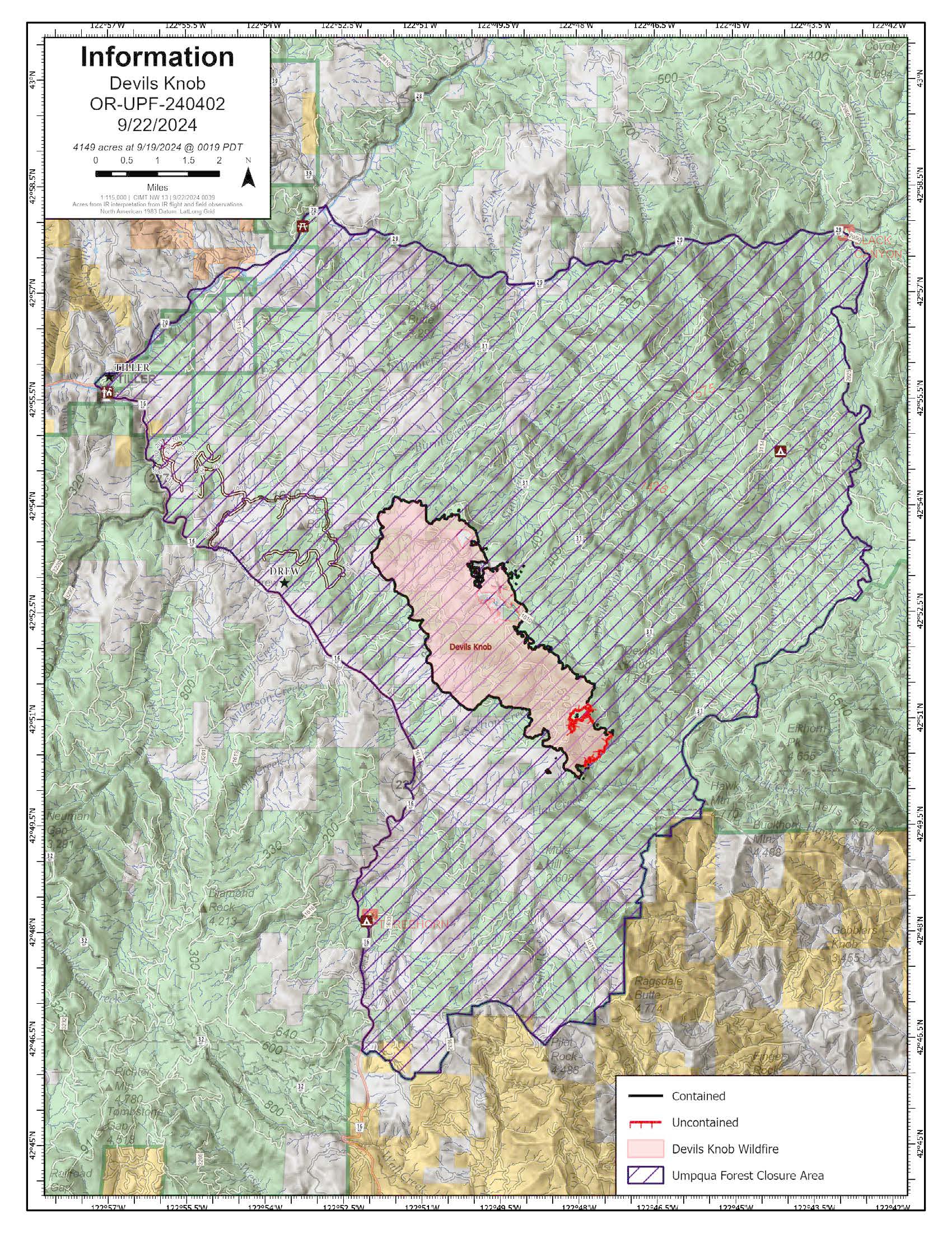
Devils Knob Fire Update 09 22 2024
Related Incident:
Publication Type: News
Devil’s Knob Fire Update for Sunday, September 22, 2024
KEY MESSAGES:
On Saturday, September 21 at 6:00 p.m., Complex Incident Management Team NW 13 transitioned management of the Devil’s Knob fire to a smaller Type 3 team. The new team’s operational objective is to contain the fire to its current footprint and repair resource damages caused by fire suppression efforts before turning the incident over to the local unit.
CURRENT STATUS:
Crews are completing mop-up operations and will continue patrolling, monitoring, and conducting suppression repair where needed. This work is designed to reduce the opportunity for fuels to rekindle, mitigate suppression impacts, and complete repairs to standard.
WEATHER / FIRE BEHAVIOR:
Dry weather is expected to continue through Tuesday, with light winds and afternoon temperatures climbing into the mid-to-upper 70s. A front is anticipated to move into the area on Wednesday afternoon bringing cooler temperatures and possibly a few showers by Wednesday night. While the fire is expected to remain inside the current perimeter, some snags, stumps, and heavy fuels may continue burning within the existing fire footprint, contributing to visible smoke in the area.
SAFETY AND CLOSURES:
Umpqua National Forest closures: https://www.fs.usda.gov/alerts/umpqua/alerts-notices
Umpqua National Forest fire restrictions: https://www.fs.usda.gov/main/umpqua/fire
Bureau of Land Management fire restrictions: Oregon-Washington blm.gov page
Douglas Forest Protective Association fire restrictions: https://www.dfpa.net/public-fire-restrictions
Oregon Dept. of Forestry restrictions: https://www.oregon.gov/odf/fire/pages/restrictions.aspx
Bachelor Complex Flat Top and Firestone Fires Update 09 22 2024
Related Incident: Flat Top and Firestone FiresBachelor Complex Fires
Publication Type: News
Northwest 3 Complex Incident Management Team
Lonnie Click ~ Incident Commander
September 22, 2024
Bachelor Complex, Flat Top and Firestone Fires Update
September 22, 2024
Quick Facts: Bachelor Complex
Size: 11,741 acres
Start Date: Sept 8, 2024
Location: 20 miles SW Bend, OR
Personnel: 292
Containment: 39%
Quick Facts: Firestone & Flat Top Fires
Start Date: Sept 6, 2024
Location: North of Fort Rock, OR
Personnel: 116
Firestone Size: 9,462 acres
Containment: 90%
Flat Top Size: 36,362 acres
Containment: 86%
At 6:00 p.m. today, Northwest Complex Incident Management Team 3 will transition command of the Bachelor Complex to a Central Oregon Type 3 incident management team, while command for Flat Top and Fire Stone Fires will be returned to the Deschutes National Forest and a Type 4 incident commander.
Dry vegetation and very low humidity contributed to an increase in fire activity Saturday, especially in interior pockets of unburned fuel. Fire 846, in the Kwohl Butte area, is about three acres, and firefighters anticipate one or two more shifts of work to secure the fire.
Bachelor Complex: There was increased fire activity within the interior of the Little Lava Fire as heavy fuels, such as downed logs, continued to consume themselves. On the uncontained northern edge, near Sheridan Mountain, terrain and wind direction contributed to a slight increase in acreage as the fire backed north, against the wind and topography. Near Forest Service Road 45, crews will continue disassembling hose lays and hauling out hose that is no longer needed. Patrol and mop-up efforts are ongoing as crews address areas of heat found near the line. Brush chipping operations were completed yesterday along the southern flank and suppression repair is ongoing.
Flat Top Fire: No further updates are planned for Flat Top Fire unless conditions change. An infrared flight early Saturday morning indicated heat outside the line near the northwest corner of Flat Top Fire in the area of the previous day’s burnout operation. Firefighters were able secure the two-acre spot by the end of the day. Today, crews will continue mopping-up, chipping brush and doing suppression repair as needed.
Firestone Fire: No further updates are planned for Firestone Fire unless conditions change. Crews continued to secure and deepen the line on the Firestone Fire along Forest Service Road 100. Today’s plan is to continue mop-up, patrol, brush chipping and suppression repair where needed.
Weather and Fire Behavior: Dry and warmer weather is in the forecast across the fire areas. This warming trend continues into mid-week. Given the predicted wind direction, significant fire perimeter growth is not expected.
Closures: While evacuations have been lifted, there are two temporary emergency fire closure areas on the Deschutes National Forest. To view the updated closure orders and maps, visit: https://www.fs.usda.gov/alerts/deschutes/alerts-notices.
Facebook:https://www.facebook.com/deschutesnationalforest/
InciWeb:
https://inciweb.wildfire.gov/incident-information/ordef-bachelor-complex-fires
https://inciweb.wildfire.gov/incident-information/ordef-flat-top-and-firestone-fires
YouTube: https://www.youtube.com/@CentralOregonFireInfo?app=desktop
Fire Information Line: (541) 249-9829, 8:00 a.m. to 8:00 p.m.
Smoke & Air Quality Information: fire.airnow.gov
Rail Ridge and Wiley Flat Fire Daily Update 09 22 2024
Related Incident:
Publication Type: News
Rail Ridge and Wiley Flat Fire Daily Update
9-22-24
Rail Ridge Fire
Acres: 162,423- Containment: 50% - Detection Date: Sept 2, 2024 - Cause: Lightning - Total resources: 1,376 Crews: 41 - Engines: 50 - Dozers: 17
Operational Update
Hotshot crews and other firefighting resources continue to focus efforts along the northern portion of the fire, working to identify opportunities for direct and indirect line construction along the uncontained fire edge. Crews are working to increase containment while favorable weather conditions persist in anticipation of warmer temperatures and gusting winds that are predicted next week. Mop up and suppression repair is ongoing along the southern half of the fire, where crews work to increase depth along containment lines and repair roads that were damaged during suppression activities.
Wiley Flat Fire
Acres: 30,186 - Containment: 94% - Detection Date: Sept 2, 2024 - Cause: Lightning - Total resources: 141
Crews: 2 - Engines: 3 - Dozers: 2
Operational Update Crews on the Wiley Flat Fire have been focused on establishing containment along the last section of perimeter without control lines in place. Road rehabilitation and suppression repair are ongoing around the fire as firefighters work to restore sensitive areas within the fire footprint to identified standards.
Closures and Evacuations
Rail Ridge Evacuations: All level 1 and 2 evacuation zones have been lifted for Grant County, and level 3 zones have been downgraded to level 2 “set” status. For Crook and Wheeler counties, all evacuation statuses have been lifted.
Wiley Flat Evacuations: All areas inside the fire perimeter are designated Level 3 Evacuation zones. The area encompassing approximately one-half mile from the fire perimeter is designated Level 2 evacuation zone.
For Current Evacuation Levels in all counties, please visit: https://linktr.ee/RailRidgeFire
Closures: The U.S. Forest Service and Bureau of Land Management have implemented closures for the Rail Ridge and Wiley Flat Fires. For more details and closure maps, visit https://linktr.ee/RailRidgeFire
#RailRidgeFire2024 #WileyFlatFire2024 #FireYear2024
Central Oregon Wildfire Information: centraloregonfire.org
Email:2024.railridge@firenet.gov -Phone:541-208-7111
Social Media, Evacuation and Closure Information: https://linktr.ee/RailRidgeFire

Ruby Fire Update for Sunday September 22 2024 09 22 2024
Related Incident: Ruby Fire
Publication Type: News
Ruby Fire Quick Facts
This is the last update unless significant fire activity occurs.
Size: 1336 acres Location: North Cascades National Park, Ruby Mountain, Diablo, Washington
Containment: 0% Cause: Lightning/Natural
Start Date: August 9, 2024 Fire Personnel: Incident Commander Type 4 (ICT4), Type 3 helicopter and crew and local fire personnel
Fire Information: 360-208-8096
Inciweb: https://inciweb.wildfire.gov/incident-information/wancp-ruby-fire
Email: 2024.Ruby@firenet.gov
Current Status: This will be the last update unless significant fire activity occurs. Today the Ruby Fire is transitioning from the current Incident Commander (IC) to the local unit. Yesterday saw an increase in visible smoke. This was not due to an increase in fire activity. Smoke has been settling low in the drainages and valleys due a stable airmass in place. Today brings a chance of showers in the afternoon with Monday and Tuesday experiencing warmer and drier conditions. Most fire activity is near the west side of Panther Creek on the east slope of Ruby Mountain. Fire personnel continue to monitor the fire for concerns or changes. Travelers should use extra caution when traveling on State Route 20 (SR20) near Colonial Creek Campground to avoid inhibiting active firefighting operations. Panther Creek Trail and Thunder Creek Trail north of Junction camps are closed.
Planned Actions: Firefighters will continue to support fire suppression efforts and be ready to protect critical infrastructure such as campgrounds, SR20, trails, and backcountry camps in preparation for possible fire growth. The Ruby Fire is a full suppression fire, and firefighters are using tactics with the highest chance for success, while reducing safety risks to themselves and the public.
Weather: To visit current weather please visit: https://forecast.weather.gov/
Closures: Multiple closures remain in place for public safety. Panther Creek Trail and Thunder Creek Trail north of Junction camps are closed. Go to the park website https://go.nps.gov/fireclosures for a complete list.
Smoke: To view current air quality visit: https://www.airnow.gov.
Burning Restrictions: There are currently no fire restrictions in place: https://go.nps.gov/ban-lifted.
Drone Restrictions: If you fly, we can’t. Drones can jeopardize firefighting efforts, and operating drones within North Cascades National Park is prohibited, except with prior written approval from the superintendent.
Cooperating Agencies & Tribes: National Park Service, Upper Skagit Indian Tribe, Seattle City Light, Whatcom County, Whatcom County Sheriff’s Office, Washington State Dept. of Transportation, Washington DNR.
To sign up for Ruby Fire updates, email: 2024.Ruby@firenet.gov Thank you.